Friday, December 30, 2011

12/30 - 3:30pm - A Good Day to Fly a Kite in Kentucky

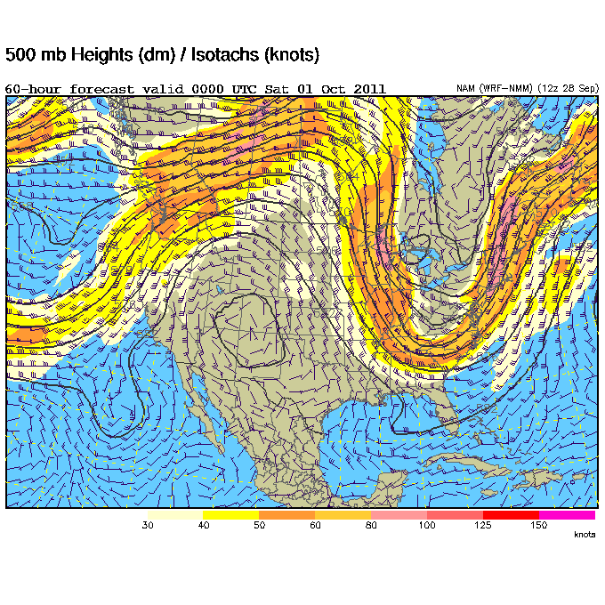
Gusty winds will continue through this afternoon in Louisville and most of Central Kentucky as a storm system in the Midwest creates quite the pressure gradient for strong winds. Winds at 5,000 feet (850 mb in weather geek speak) are high right now, surpassing 50 kts or 60 mph as you'll see in the orange shade on the left image. The peeks of sunshine we're seeing are allowing these winds to mix down to the surface due to heating, and that's why we're having the higher wind gusts.

The National Weather Service has issued a Wind Advisory for areas just south of Louisville since wind gusts have been hitting the criteria for this down that way. Even without the Wind Advisory, Louisville could see gusts surpassing 30 mph this afternoon as a cold front continues to approach from the west.

Check out some of the wind speeds and gusts from around the region as of 3pm. I've highlighted the wind gusts that are close to Wind Advisory criteria in orange and the ones that exceed the criteria (40 mph) in red:

Louisville Airport:   SW 17 mph, gusting to 24 mph
Bowman Field:         SW 18 mph, gusting to 29 mph
SE Louisville:          SW  9 mph,  gusting to 26 mph
Fort Knox:               SW 23 mph, gusting to 33 mph
Lexington:                SW 21 mph, gusting to 39 mph
Frankfort:                 SW 23 mph, gusting to 44 mph
Bowling Green:        SW 17 mph, gusting to 29 mph

More cities and observations are available hourly on the NWS's State Weather Roundup. A few light showers will be possible this evening in Louisville and surrounding areas as this front moves through.

Monday, December 26, 2011

12/26 - 12:30pm - Post-Christmas Snow Chance?

While many did not have a white Christmas yesterday, it certainly was a nice day across much of the East US with warm temperatures. We now turn our attention to a system that will be bringing much of the Southeast rain and possibly some snow as you head northward. This system is brewing in the Gulf Coast states right now and will bring West Tennessee rain this afternoon through tomorrow and the Louisville area rain tonight through tomorrow. While West Tennessee will likely stay all rain throughout the duration of this system due to warmer temperatures, Kentuckiana may have to deal with some snowfall during the afternoon tomorrow. The track of this storm from Tennessee to Eastern Kentucky is usually one that gives us our bigger snow events during the winter, but this time that won't be the case because of the lack of cold air we'll have to work with.

The forecast for snow is a tough one because we'll be dealing with colder air coming in on the backside of this system to give us our snow. This means that the atmosphere will cool from top to bottom and while snow will be falling it will likely not accumulate much, if any, because the air at the surface will still be warm while the upper atmosphere cools down. Nevertheless, a switchover to snow in the Louisville area will likely happen sometime tomorrow during the early to mid afternoon hours as cold air penetrates enough of the atmosphere to keep snow falling all the way to the surface. The NAM (left) seems to be the most aggressive on this switchover right now due to the surge of cold air it brings in early on in the afternoon in Louisville but the forecast sounding, or a vertical snapshot of the atmosphere at a given time, still indicates that we'll have temperatures just above freezing near the surface. This means that snow will be making it to the ground, but will likely melt on contact or accumulate lightly on the grass and elevated areas in heavier snow bands. Speaking of banding, that's another issue we could face. Snow banding is when you get a thin strips of heavy snow falling that look like bands due to winds coming together in these areas. These bands can produce snow accumulations even when temperatures are above freezing, just like in Jackson, Tennessee earlier this month when over an inch of snow accumulated with temperatures just above freezing.

Overall, I think areas in and close to Louisville can expect a dusting and maybe up to an inch of snow on grassy and elevated surfaces at some point tomorrow evening. If cooler air does not come in as quickly as expected this will remain a rain/snow mix or even just plain rain. Areas north and west of the Ohio River have the best shot for a light accumulating snow as they'll be slightly cooler and have an earlier switchover during the late morning hours. Most of the models are agreeing that we'll stay above freezing during most of this event, but we will be dipping down below that mark late Tuesday evening. This may create slick spots if any roads are wet from the snowfall during the afternoon. The 12z NAM (top left) is indeed the most aggressive on snowfall totals around here by looking at the snowfall output map, which you can see a larger view of by clicking. The 0z GFS (bottom left) is less aggressive, which is typical for it lately, and the Euro (which I cannot post here to copyright policies) keeps the snowfall along and north of the Ohio River. There are still a lot of small variables like exactly how fast the precipitation will move out of here and how much cold air will actually work into this process, so little details like these can drastically alter who gets snow and how much.

Saturday, December 17, 2011

12/17 - 11:50pm - A Not So White Christmas

Positive NAO - http://www.ldeo.columbia.edu/NAO
Christmas is just a week away and snow chances for many in the eastern half of the nation look pretty bleak. The next major system to pull through on Tuesday and Wednesday will produce snow in the Plains, but to the east it's expected to be all rain. A second low moving through the Deep South on Friday will bring more rain, but most of that will stay south of Kentucky and the heaviest south of Tennessee. After that point it looks pretty dry right through Christmas. Why so rainy and relatively warm lately? It has to do with the North Atlantic Oscillation, or NAO for short. When the NAO is negative, storms tend to ride up the East Coast or just west of the Appalachian Mountains. This is a recipe for snow for many across the East since these storms have cold air streaming in just to the north of their track. When the NAO is positive, storms begin deflecting northward to Canada before they reach the Mississippi River. This means that the cold air and snow with these storms stays out in the Plains. The NAO is in this positive phase right now and isn't forecast to go neutral or even negative until around the new year (see forecast and history chart to the right). Until we can get the NAO negative, I wouldn't bet on a winter storm for Kentucky, Tennessee, or much of anywhere else in the East.

23% of the United States is covered by snow at the moment, which is quite a bit lower than the 47.3% covered by snow at this time last year. Aside from Lake Effect snowcover in Pennsylvania and New York and snowcover in northern Maine, the East is snow-less.

A big winter storm is forecast to hit New Mexico, the Texas/Oklahoma Panhandles, and Kansas on Monday and Tuesday as an area of low pressure cuts northeastward (because of the positive NAO as explained above) through the Plains. A Blizzard Warning (green color on right image) has been issued for Northeast New Mexico while the other areas are under a Winter Storm Watch. Areas in the core of the snowfall north of Amarillo, TX up through Dodge City, KS could get well over a foot of snow.

Monday, December 12, 2011

12/12 - 7pm - A Few Bits About Snow

While things have since quieted down snow-wise, it has been a very snowy start to the season in West Tennessee. Jackson, TN has had 3.3 inches of snow so far this season, which is an astounding figure given that only about 0.1 inches falls on average by this time of year. This total beats out the season totals in many northern cities, some of which are known for their heavy snowfall including Buffalo, New York and Bismarck, North Dakota. Check out the graphic on the left to see a full list of some of the cities that Jackson is beating out. The rain to snow chance on the 21st isn't showing up on the models right now because they're dissolving the upper-level low before it makes it past NW Arkansas, but it's something to keep an eye on. A few flakes may fly further north near Louisville, but even that's not going to be a big deal according to the models. Another system packing precipitation and cold air may try to roll through a couple days before Christmas too, but that's way to far down the road to make guesses for any location at this point.

Speaking of snow, did you know that the Grand Canyon in Arizona gets more snow than Minneapolis, Minnesota? It's true! You may think of Arizona as a dry and hot state, but the higher elevations in the northern regions near Flagstaff get quite a bit of snow. Grand Canyon Village, AZ at the top of the canyon is expected to get 4 to 10 inches of snow by Wednesday morning while Flagstaff could get 12 to 16 inches. These areas are under a Winter Weather Advisory and Winter Storm Warning respectively.

Saturday, December 10, 2011

12/10 - 2:30pm - A Cool Weekend Before the Rain

The sunshine and drier air moving in helped us get into the lower 40's this afternoon in Jackson. This is a welcome surprise since all indications this morning were pointing to a high only in the upper 30's. Tomorrow will be a day like today again in the 40's with plenty of sunshine. By the middle of next week we'll be talking warmer temperatures in the 50's and 60's, but rain chances will be on the increase. Thursday looks to be the best shot at rain in West Tennessee as a cold front generates a line of thunderstorms that will move though ahead of the front. Some of these could be on the strong side, so this is something we'll have to keep an eye on. Be sure to click on your Hokey Weather Fact of the day on the left, which relates to the movie A Christmas Story, and check out your full forecast from this morning's edition of Good Morning West Tennessee on WBBJ below:

Saturday, December 3, 2011

12/3 - 2:45pm - Batten Down the Hatches, Heavy Rain is Coming!

West Tennessee and North Mississippi are going to be inundated with heavy rainfall starting tomorrow and lasting through Tuesday. The HPC's latest 12z rainfall forecast (right) has over 5 inches of precipitation in portions of Northwest Tennessee by the time this is all said and done, but amounts of 2 inches and over will be quite common across the area. Flooding will no doubt be a concern since this rain will fall on already saturated ground in a relatively short period of time (mostly Sunday and Monday), so the National Weather Service has issued a Flood Watch for the entirety of West Tennessee for Sunday morning through Monday night. The Tennessee and Mississippi Rivers will have to be watched during this, along with those low-lying areas that usually flood during these kinds of heavy rainfall events. After the rain and accompanying cold front move through, cooler temperatures and dry weather will be the rule for Wednesday and the remainder of the week. Check out my complete forecast on WBBJ this morning below for all the details:

Wednesday, November 30, 2011

11/30 - 4pm - Mid-South Winter Storm Wrap-Up

The National Weather Service in Memphis has released a snowfall map that recaps the measured snowfall totals across the Mid-South. Jackson, TN broke an all-time November snowfall record with 2.0", but note that slightly higher totals were recorded elsewhere in Madison County away from where the official observations are taken for the NWS. Look at those snowfall accumulations of over 5" in Northeast Arkansas and the Missouri Bootheel... very impressive! This was quite a rare storm and the method through which the storm produced the snow, a cut-off low that supplied its own cold air from aloft, is something that doesn't happen too often either.


The snow was even apparent on visible satellite this morning, which is amazing because temperatures were above freezing for most of yesterday:


Wintry weather should stay out of the forecast for at least the next week or so, but rain chances will be on the increase in West Tennessee early next week. The GFS computer model is hinting at the possibility of a little bit of snow late next weekend, but it's much too far out to make any predictions at this point. Certainly something to watch!

Monday, November 28, 2011

11/28 - 8pm - Starkville Christmas Parade Weather Report

This evening WOBV-TV 5 in Starkville, MS aired a weather forecast I put together for this year's Starkville Christmas Parade TV broadcast. Check out this video from tonight's program:


Scroll down to see my thoughts about the ongoing winter storm impacting much of the Mid-South right now.

11/28 - 2:45pm - An Early Shot of Winter Weather

A complicated upper-level low is making for some difficult forecasting over the next 24 hours as it brings the first real chance of snow to the South this season. This upper-level low is basically a big bubble of cold air aloft that has been orphaned from a bigger system that has since moved away from the region. Since we still have showers in the area, this cold air will help to turn those into snow by late tonight in areas near Starkville and northward. Since temperatures at the surface here in Starkville won't make it above 34 or so, any brief period of snow we see will not stick to the ground. I do think there could be a complete changeover to snow here in Starkville tomorrow morning around 8 or 9am, but this is highly dependent upon how well the computer models handle this system. Further north near Tupelo, Memphis, and Jackson, TN there will be enough cold air to get the snow on the ground when it falls, but the vast amount of warm rain we've had lately has kept the ground warm and moist, so snow accumulations won't stick around for long. Travel hazards won't be a huge deal since the roads are still warm, but it's a good idea to keep a look out for slick spots where temperatures dip below freezing tonight. Click on the SREF model snow output to the right... I think it has the most reasonable estimate on who will get accumulating snow tonight.

A Winter Storm Watch has been issued for areas from Tupelo to McNairy County, TN until 6am tomorrow since heavier snow could result in accumulations of 3 inches or more. The Winter Weather Advisory around the periphery of the Watch is for wet snow accumulations that could total around 1 to 3 inches. The snow should end by late morning tomorrow as it converts back to rain showers and then the precipitation will clear the area completely by around noon or so.

Check out my video below for a complete look at this week's forecast in Starkville and more details about the snow that's headed our way:


This evening at 6pm is the annual Starkville Christmas Parade. I'll be doing a short weather segment for the parade broadcast on WOBV 5 in Starkville. This event will also be streamed live on the web, so be sure to check out http://parade.wobv5.com/ tonight at 6pm CST to see my forecast and enjoy the parade!

Sunday, November 20, 2011

11/20 - 12:15pm - Active Weather on the Horizon

Heavy rain and storms are going to be sticking around the Southeast for the next couple of days as a stalled front sets up just northwest of Tennessee and Kentucky. Rainfall amounts in West Tennessee through Central Kentucky could exceed two inches by the time this is all said and done on Wednesday morning, leading to some flooding issues in areas (such as Northwest Tennessee) that have seen quite a bit of rainfall already this month. Something that has become more apparent this morning is the risk for severe weather on Tuesday (left image), when upper-level wind support will come in to play. The greatest risk for severe storms will be throughout most of Mississippi and West through Middle Tennessee. This severe weather threat will likely materialize as a line of storms carrying high winds and the risk for a few isolated tornadoes, but there could also be a few storms out ahead of the main line as well. Once we clear the storms out on Wednesday we'll be left with sunny skies and cooler temperatures throughout the region, giving us a very nice Thanksgiving! Check out the video below for my forecast on yesterday morning's edition of Good Morning West Tennessee on WBBJ:

Monday, November 14, 2011

11/14 - 12:45pm - Severe Risk Tomorrow in Mississippi

It's a dreary and humid one out there today but a Slight Risk of severe weather is in place for tomorrow across the western 3/4 of Mississippi as a potent system approaches. Severe storms are also possible around the Golden Triangle tomorrow as heavy rain, high winds, and even some hail moves through the region. This should clear out by Wednesday afternoon and leave us with clearing skies and cooler temperatures for the remainder of the week. Check out your complete forecast in the video below:

Saturday, November 12, 2011

11/12 - 2:30pm - Hold on to Your Hats!

It's going to be a windy and warm weekend across West Tennessee. Winds will likely reach 15 mph today and 20 mph with higher gusts on both days. Temperatures are going to be very nice, getting into the lower 70's by tomorrow afternoon. Rain will move through on Monday night, some of which could be quite heavy and will last until Tuesday morning. After the cold front generating these storms moves through on Tuesday, we'll be seeing temperatures only getting into the upper 50's by Wednesday. Check out the video below for all the details!

Monday, November 7, 2011

11/7 - 2:30pm - Sunny and Warm, Then Storms

If you haven't stepped outside today, you really need to do so. It's 72° in Starkville as of this writing and the mostly clear skies couldn't be any nicer. That will continue into tomorrow when we'll see highs near 80 degrees in some locations across North Mississippi and maybe a few more clouds. Storms will roll through on Tuesday night into Wednesday, but I don't expect any severe weather in the immediate Starkville/MSU area because of a lack of moisture to fuel these storms. On the other had, areas near Lawton, Oklahoma to just north of Abilene, TX are in for a good shot of severe weather with tornadoes possible. This threat will shift eastward to Eastern Oklahoma and Arkansas tomorrow with a few strong storms even making it to the Delta region of Mississippi. After the system bringing these storms passes through on Wednesday morning, we'll be left with much cooler temperatures and quiet weather. Check out my forecast video below for more details:

Saturday, November 5, 2011

11/5 - 2:45pm - A Foggy Start to a Nice Weekend!

It was extremely foggy in West Tennessee this morning as low-level moisture and chilly temperatures set in overnight. This morning on TV I showed a photo (left) from Kelton Halbert of the very low visibility at the Nashville International Airport early this morning. What a sight! The fog has dissipated and we'll be left with a very nice weekend with temperatures in the upper 60's to 70 degrees before our next rain chance on Tuesday night. This rain chance entails some strong storms, but current indications are that most of the severe weather will stay west of the Mississippi River as it rolls through on Tuesday night into Wednesday morning. Expect cooler temperatures for the end of the workweek. Check out the video below for your complete forecast:

Saturday, October 29, 2011

10/29 - 4pm - The Hokey Halloween Cape Returns!

In the spirit of Halloween I wore my famous Hokey Halloween cape on-air this morning during a couple weather segments. It was really cold out there during our show, getting down to 28 degrees at the lowest point. After seeing 60 for a high in Jackson today we should bump up to near 70 by the middle of next week. A weak cold front will pass through on Monday, but that shouldn't really impact conditions much. Storms on Thursday will be our next rain chance before getting much cooler again for next weekend. Check out the video below to see the caped forecaster!


As if the cape weren't enough, a stolen SUV that police were looking for sped into the parking lot at WBBJ-TV around 4am while I was working on my forecast graphics. The suspect driving the vehicle fled on foot after attempting to find a way out. Master control, who monitors the security cameras, immediately called the police and K9 units were on the scene within minutes. All of us inside the studio and newsroom were obviously spooked because the suspect was on the loose for a few minutes as police tried to locate him. How often does breaking news come right to the door of a TV station? Wow! Check out the video below for the full story:

Monday, October 24, 2011

10/24 - 12:45pm - Foggy Start, Warm Day!

Some thick fog developed over portions of Mississippi this morning causing some visibility issues across the region. That has since cleared out and we're left with clear skies and temperatures that will be getting into the middle 70's this afternoon in Starkville. We'll warm it up to around 80 by Tuesday, but thunderstorms are on the way for Thursday and Friday as a cold front passes through on Thursday. Not expecting any severe weather at this point, but drier areas to our north will benefit from the rain greatly. Things should really cool down behind the front this weekend and skies will clear as well. Check out your detailed forecast in the video below:

Saturday, October 22, 2011

10/22 - 12:30pm - Warmer Temperatures in West TN, then Snow?

Jackson, TN bottomed out at 32 degrees this morning, which is two degrees warmer than our low temperature yesterday but still very chilly. We'll warm things up gradually around West Tennessee this weekend with 60's for highs today, 70's for both tomorrow and Monday, and 80's for Tuesday. What a warm-up! A cold front coming through on Wednesday night will generate some thunderstorms for Wednesday and Thursday, possibly into Friday as well. This system has slowed down on the computer models a little bit, but I think we should have all the rain out of here by Friday evening. It will be MUCH colder behind this front and as NWS Memphis points out, there's even a hint of some hypothetical snow on the computer models with this system:
IN FACT...LATEST MODEL GUIDANCE INDICATES AN UNSEASONABLY COLD UPPER LEVEL LOW MOVING
ALONG OR SOUTH OF THE INTERSTATE 40 CORRIDOR NEXT THURSDAY NIGHT INTO FRIDAY WITH 925 MB TEMPERATURES NEAR ZERO AND 1000-500MB THICKNESSES SUB 540 DAM. IF THIS WERE TO OCCUR...THEN IT WOULD BE POSSIBLE THAT SOME WET SNOW COULD MIX WITH THE RAIN IN SOME LOCATIONS THURSDAY NIGHT INTO EARLY FRIDAY MORNING. OBVIOUSLY THIS SYSTEM IS STILL SEVERAL DAYS AWAY AND THIS SCENARIO IS UNLIKELY CONSIDERING THAT WE ARE STILL IN LATE OCTOBER.
Honestly I don't think much if any snow will make it to the ground on Thursday night, but it could be close as some very cold air filters in behind that cold front. Check out some video from this morning's edition of Good Morning West Tennessee on WBBJ below:


I'll be on the 6pm and 10pm shows this evening (which will likely air a few minutes later than their assigned times due to football on TV), so be sure to tune in and check out the latest changes in your forecast!

Monday, October 17, 2011

10/17 - 11:30pm - NWA 2011 Meeting Wrap-Up

Both yesterday and today I attended and volunteered at the 36th Annual National Weather Association Meeting in Birmingham, Alabama. This was the most-attended NWA meeting in history and evidence of that was clear this morning when there were no more seats for attendees! The volunteer portion of my attendance had me taking video of research posters from students and professionals for the agenda on the NWA website. While the meeting runs until Thursday, I had to leave late this afternoon to attend to class-related things back in Starkville. I wish I could've stayed longer because this was one of the best put together functions I've ever attended.

Speaking of attendance, I was able to meet quite a few experienced broadcast meteorologists while I was there. Some of those folks were Jim Cantore (The Weather Channel), Jacqui Jeras (CNN), Christie Dutton (WAVE-TV Louisville), Ryan Vaughan (KAIT-TV Jonesboro), Mary Wasson (YNN Austin), and Dave Freeman (KSNW Wichita). It was also great to see some old friends whom I've met before in Starkville at the Mississippi State Severe Storms Symposium.

The sessions that took place while I was there mostly focused on the historic tornadoes from this past year, and some of these spurred some really great discussion on how we as broadcast and operational meteorology professionals can improve our methods to save lives in severe weather. One of the things that strikes me from multiple presentations is the public's low use of NOAA weather radios. While these are lifesaving devices, it's clear that these things are very difficult to operate if you're not familiar with consumer electronic devices or don't understand how SAME codes work. This is a huge problem because people then depend on less reliable means of receiving warnings like tornado sirens. As I tweeted earlier today, Dave Freeman suggested that weather radios should use ZIP codes instead of SAME codes to separate out warnings. This would be much easier because just about everyone knows their ZIP code, but almost nobody (including me!) knows their county SAME code without consulting the NWS website. It's true that this wouldn't be an easy solution since either the radios or warning system would have to be able to identify ZIP codes based on coordinate polygons and because some ZIP codes are way too big. In the long run though, these would be relatively minor changes to a system that's had years of development behind it.

There's also been talk from a lot of people suggesting the placement of GPS chips in weather radios to determine exact location so that there's even less of a chance of the radio going off for a warning that does not pertain to the user. This is also a great idea that wouldn't require terribly huge changes to radios and how warnings are issued. Overall, I gathered from today's and yesterday's presentations that more needs to be done to make severe weather warnings more accessible and understandable to the public to save lives in events like April 27th. The technology is there and the ideas are in place, and the recent tornadoes that claimed so many lives this year are proof that these changes are necessary.

Saturday, October 15, 2011

10/15 - 3pm - It's Blast Furnace Time in West Tennessee!

Are you ready for a big warm-up? As high pressure shoves eastward we'll be seeing southerly winds bringing in some very warm air this weekend. This will push highs into the middle 80's for Sunday and Monday, which is almost record-breaking for West Tennessee. A cold front will bring an end to the warm temperatures on Monday night and storms appear likely. Some of these could be on the strong side, but we're not expecting a severe weather outbreak at this point. Temperatures behind this front may struggle to reach 60 on Wednesday, but we'll warm into the upper 60's by the end of the workweek. Check out my video below for a full forecast!

Monday, October 10, 2011

10/10 - 1pm - A Few Showers Around Mississippi

Moisture from the area of low pressure over Florida is providing us with a few rain showers across Mississippi today. These will likely continue throughout the day and taper off tomorrow. Not everyone will see rain, but don't be shocked to find a few raindrops falling at your location this afternoon. A cold front will move through on Wednesday evening and increase the potential for a few showers and storms, but after that point we'll see cooler temperatures and sunny skies as we head into the weekend. Check out the video below for more details:

Sunday, October 9, 2011

10/9 - 2pm - Can We Get Some Rain?

It's been over two weeks now since rain has been recorded in Jackson, TN, but luckily there are some rain chances in the forecast. If you look off to the east you'll see a deck of high, thin clouds that will be moving into the area later this evening. These clouds are a general outline of the westward-moving tropical moisture that will power the chance for a few showers across West Tennessee tomorrow. A more appreciable rain chance with some thunderstorms will arrive on Wednesday night as a cold front passes through. After that point we'll be left with clear skies and temperatures only in the 70's.

Check out some clips from my weathercasts on Good Morning West Tennessee and the 6pm news on WBBJ yesterday for more details on this week's weather:


Monday, October 3, 2011

10/3 - 2:30pm - Gradual Warm-Up on the Way!

After having lows in the upper 30's this morning across much of North Mississippi and the Golden Triangle, we're enjoying temperatures in the lower 70's this afternoon. High pressure will gradually move east of us this week, meaning southerly warm winds will return to the region. Warmer temperatures are on tap throughout the week here in Starkville, getting into the mid 80's by the time we cap off the workweek on Friday. The next chance of rain will be sometime early next week, so enjoy this nice stretch of weather! Check out the video below for your detailed forecast:

Saturday, October 1, 2011

10/1 - 3:30pm - October Comes in Cool

Across West Tennessee this morning we saw overnight lows in the upper 40's, but luckily we've warmed up to a slightly chillier-than-average 66 degrees so far. Tonight's lows across the region will be in the mid to upper 30's. Low-lying valleys and other areas prone to cooler temperatures could see patchy frost early tomorrow morning. The rest of the week features warming temperatures and sunny skies. That's a pleasant and easy-to-digest forecast for sure! Check out the video below for some highlights from my weathercasts on this morning's edition of Good Morning West Tennessee on ABC 7:

Wednesday, September 28, 2011

9/28 - 9pm - Big Pattern Change Coming Up

A pretty sizable pattern change is shaping up for the entire Southeast that will result in some very seasonable fall weather. A large upper-level low that's been spinning over the Great Lakes for the past few days will be replaced by another trough that should dig even deeper than the current one. At the surface this will push quite a cold front through the region on Friday, which will bring in much drier air from the northwest and cooler temperatures. We're talking dew points into the 40's (60 is considered humid) over the weekend with overnight lows getting into the 40's in most locations around Mississippi and Tennessee. It will take until the middle of next week to regain some of the humidity as this trough moves east and a ridge builds in. Until then, enjoy the clear, crisp, and cool days ahead!

Be sure and tune in to Good Morning West Tennessee on WBBJ ABC 7 this Saturday at 6 and 8am for my latest West Tennessee forecast. Should be a very nice weekend!

Monday, September 26, 2011

9/26 - 12:30pm - Mississippi State Forecast

Last night there were four reports of tornadoes in Bolivar County, Mississippi. These were probably caused by two distinct tornadoes, one near Benoit and another that caused substantial damage to two department stores and a subdivision in Cleveland. Any severe weather that occurs today as a cold front pushes south will likely stay near the I-20 corridor, so Starkville and the surrounding area should continue to see some pop-up spots of drizzle and mist throughout today and tomorrow. This front will stay stationary tomorrow, but once it pushes out of the region by Wednesday we'll clear out the clouds and drizzle here in Starkville. Check the video below for more details:

Sunday, September 25, 2011

9/25 - 2:45pm - A Full Saturday at WBBJ

Yesterday I did weather on the 6am and 8am Good Morning West Tennessee shows and the 6pm and 10pm newscasts at WBBJ. It's always great to be able to fill-in for other shows, but boy I was bushed after such a full day, especially since I'm still recovering from a bout with bronchitis! The forecast was a bit of a challenge since rain showers unexpectedly formed yesterday well ahead of the cold front that is to pass through early tomorrow morning. Severe storms are still expected this afternoon around West Tennessee and then things should clear out nicely for the workweek. Check out the videos below to see a couple samples of my forecasts from yesterday.


This weekend's shows were a bit different visually because they were produced from our brand new control room (see below) inside our just-completed sales and production building. All the new equipment allows us to now broadcast in-studio camera shots in 16:9 widescreen, so you're getting a much fuller picture compared to what we had before. The studio and newsroom are both under heavy construction right now, so you'll likely see some major changes in those in the coming months too. We're all pretty excited to see what the future has in store for the station!

Monday, September 19, 2011

9/19 - 12:45pm - Rain's Coming Our Way!

After seeing some showers this morning, more rain in on its way to Starkville. Scattered showers and storms will continue through tomorrow with a small break thrown in on Tuesday evening before more storms push through on Wednesday and Thursday. Check out your latest forecast in the video below:

Saturday, September 17, 2011

9/17 - 3:30pm - Spotty Showers in West Tennessee

We saw a few showers across West Tennessee this morning, but as expected they've mostly cleared out of the area for the afternoon. More showers are possible tomorrow, but the big show (relatively speaking) arrives on Monday with some appreciable rain chances as a cold front approaches the region. Check out my forecasts from last night's 10pm show and this morning's Good Morning West Tennessee newscast on WBBJ below:


Monday, September 12, 2011

9/12 - 2:30pm - MSU Forecast Update

Those pop-up showers and storms around North Mississippi yesterday won't see the light of day this afternoon, leaving us with warmer temperatures and sunny skies. Tomorrow will be the same story, but Wednesday will be a transition day of clouds and a small chance for rain as a cold front approaches the region. The end of the workweek, which includes a football game against LSU on Thursday, could be a bit wet as the front pushes through. Check out your latest Mississippi State forecast in the video below:

Saturday, September 10, 2011

9/10 - 2:30pm - Quiet Weather in West Tennessee, GMWT Video

All is quiet in West Tennessee save for some scattered showers and possibly a storm that could form later this afternoon. Tomorrow's forecast looks fairly similar with temperatures running a couple degrees or so warmer. Once Monday rolls around, the upper-level low causing these shower chances should move east out of the area and completely sunny skies will take over. Rain chances will increase yet again during the middle part of next week. Check out the video below for a complete forecast:


I want to give a shout-out to anchor Will Nunley, who is leaving WBBJ today for other opportunities.

The tropics are active this weekend, but not for the United States. Tropical Storm Nate is tracking into Mexico and Tropical Storm Maria is recurving out to sea on what is historically the peak of hurricane season in the Atlantic. The season runs until November 30th.

Sunday, September 4, 2011

9/4 - 12:30pm - Yesterday's GMWT Video, TS Lee Update

Yesterday we began airing Good Morning West Tennessee for an additional hour starting at 8am. This means the Saturday show is now two hours, from 6-7am and again at 8-9am with Good Morning America airing in between. The forecast for West Tennessee still looks very wet today into tomorrow because of Tropical Storm Lee, but I think the rain should clear out as Labor Day rolls along. Check out some video from yesterday's broadcast below:


Lee is just hanging on to tropical storm status and should be downgraded to a depression later today as it moves inland. Just because it's weakening doesn't mean the risks from it will go away. Portions of Central Mississippi (I'm talking to you Starkville), Alabama, and even up through the Appalachian Mountains in North Carolina could see over eight inches of rain between now and Tuesday. Flooding is obviously a concern, so use caution while driving in these areas. Turn around, don't drown!

Tornadoes are also continuing a problem with Lee. There were 10 reports of tornadoes yesterday, some causing damage, along the Gulf Coast from Louisiana to Florida. Two tornado watches are in effect with about a half dozen warnings in them from Mississippi to Florida. The tornado risk from Lee should lessen as it continues to come onshore tonight and tomorrow.

Monday, August 29, 2011

8/29 - 3:15pm - First Day of Broadcast Meteorology Lab

Today was my first day of broadcast meteorology lab here at Mississippi State. Most of you probably realize that I have a bit of a head start in this class, but there is always something to learn and I really enjoy helping others learn in a field that I love so much. Each of us started out the semester with an informal "first forecast" to break the ice and get those first-time jitters out of the way. Check out my forecast below:


It's not bad out there in Starkville today since those dewpoints are staying around 60 degrees and lower. We'll see a gradual return to the high humidity after tomorrow as Gulf moisture begins to filter back into the region. About the most exciting thing that will happen this week, excitement being used relatively here, is an upswing in rain chances toward Friday and the weekend as a cold front approaches from the north.

Thursday, August 25, 2011

8/25 - 4:15pm - Hurricane Irene's Fever Pitch

Hurricane Irene is certainly causing some drama both over the airwaves and along the East Coast where thousands are preparing for what could be that area's first hurricane strike in a while. This will also be the first hurricane to make landfall in the United States since Ike in 2008. States of emergency have been declared by the governors of North Carolina, Virginia, New Jersey, Maryland, and New York as the storm takes aim at the region. Areas from Wilmington, North Carolina to Cape Hatteras to Norfolk, Virginia will likely take the brunt of Irene as it makes landfall as a Category 2 or 3 storm on Saturday. A Hurricane Warning has been issued for the entire North Carolina coast and a Hurricane Watch is in effect from Virginia to New Jersey. On the satellite image to the top left you'll notice that Irene does not have a very apparent eye. This is because the storm has just completed an eyewall replacement cycle, which temporarily limits both the strength of the storm and the appearance of an eye. The eye will likely become much easier to see over the next 24 hours and the intensity of the storm will correspondingly increase.

The National Hurricane Center's 5pm EDT outlook for Hurricane Irene has the storm at Category 3 status with winds of 115 mph. For Tuesday and most of yesterday, it looked like Irene was going to miss much of the East Coast and curve back out to sea, but last night's and today's computer model runs have adjusted the storm's track quite a bit westward. This means hurricane force winds will be felt across a much larger portion of the North Carolina, Virginia coasts and even through to the Northeast and Delmarva Peninsula. To the right is a "spaghetti chart" showing all the computer model forecast tracks for Irene. There's a strong possibility that Irene may still be a Category 1 hurricane packing winds in excess of 75 mph and a storm surge up to 15 feet when it hits the New Jersey Shore, New York City, and Long Island areas on Sunday. While hurricanes that affect the Northeast aren't all that rare, the particular track of Irene and the intensity possible as it hits the area are causing great concern, especially about flooding. Folks from North Carolina to New England really need to pay attention to this storm this weekend and evacuate when instructed.

Saturday, August 20, 2011

8/20 - 2:15pm - My Return to WBBJ!

This morning I did weather on WBBJ-TV ABC 7 for the first time since April. It's great to be back after a long summer break! Showers and storms that sank southward from Missouri stayed together longer than expected, so a few light showers crossed into West Tennessee earlier this afternoon along with stronger storms in the Memphis area. Additional scattered storms are possible throughout the afternoon and evening before more widespread storms cross through the region tonight through tomorrow. The passage of a cold front will mean an end to the rain by Sunday night and give way to a rather nice day on Monday. Daily storm chances are back in the forecast by mid week. Check out my forecast from this morning in the video below:

Monday, August 15, 2011

8/15 - 6pm - Severe Weather Craziness Back Home

Radar image from NWS Louisville
Saturday's severe weather in Louisville put many LG&E customers without power as winds exceeding 60 mph hit the city. At its peak the storm caused over 128,000 customers to lose power in Louisville, but that number has now dwindled down to 23,000. On radar it appears the storm may have bowed outward a bit due to the strong winds pushing ahead of it, and downbursts were likely the cause of much of the heavy damage in central parts of the city. Folks in Southeastern Jefferson County near the Jeffersontown, Middletown, Fisherville, and even down to Bullitt County saw a bit of a scary sight as the leading edge of the storm produced an arcus or shelf cloud. While not dangerous on its own this cloud often marks the leading edge of the gust front in a thunderstorm, which can carry damaging winds. Check out my photo from my back yard below:


With some schools still lacking power, Jefferson County Public Schools has cancelled classes tomorrow after already cancelling the first day of school for the academic year today. I'm not sure if JCPS has ever canceled the first day of school before, but this is certainly not the first time they've had to cancel due to power outages (wind storm of September '08 and major ice storm of January '09 are prime examples). A couple more nice weather days in Louisville will help with power restoration and tree clearing efforts.

Mississippi State Weather

I'm back at Mississippi State University for the semester and classes begin on Wednesday. The humidity been much lower in Starkville today since the passage of a cold front yesterday. Unfortunately reality will gradually return this week as temperatures surge back into the 90's and humidity increases as return flow transports Gulf moisture northward again. Daily small afternoon storm chances will return on Thursday or so.

Return to TV in Jackson, TN

If you're in Jackson, TN or the surrounding West Tennessee region, you'll want to tune into WBBJ ABC 7 this Saturday morning at 6am as I make my return to the Good Morning West Tennessee Saturday newscast. It's been about four months since my last show there due to my month-long storm chasing trip and time back home in Louisville, so I'm itching to get back to what I love doing most. We'll be bringing you weather updates every 10 minutes along with the morning's top news stories and events that you need to know about to get your weekend started!

Thursday, August 11, 2011

8/11 - 10pm - Cooler Weather Comes at a Price

SE Louisville Webcam
How about that cool down going on around the Ohio Valley? Great, isn't it? We topped out at 83 degrees just before 3pm this afternoon in Louisville. The sky was very blue today due to dry air present both aloft and here at the surface. Tomorrow should feature more of the same with slightly warmer temperatures in the upper 80's and pleasant sunshine. That's where the good news ends.

Trough position by Sunday AM
On Saturday a gargantuan trough of low pressure is going to punch its way into the Eastern US. This will disrupt our tranquil weather pattern quite a bit as conditions become favorable for a couple areas of severe storms to form. The first line of storms will likely come through during the early to mid morning hours as the trough begins to dig in and southerly surface winds bring in the initial Gulf moisture. These probably won't be too bad, but frequent lightning, heavy rain, and a few wind gusts appear to be in the cards. Depending on how long these morning storms and their clouds stick around during the later morning and afternoon hours, we could be dealing with a considerable severe weather threat later Saturday afternoon or evening as a the associated surface cold front moves through the region. If dew points do indeed recover into the mid to upper 60's during the day on Saturday and we're able to get a good helping of sunlight, Saturday night will be rough. The storms that could roll through will pack damaging winds and a flash flood risk. I cannot rule out a tornado or two embedded in some of these storms in the evening because of the wind shear that this sharp trough will be ushering in. The biggest risk for severe weather will cover Louisville and points eastward according to the National Weather Service. (Below: Saturday morning storms on the left, Saturday evening severe storms on the right.)


The Storm Prediction Center says the severe risk around the Ohio Valley is conditional at this point due to uncertainty with cloud cover and moisture return to the area (both very valid points), but these factors likely won't be known until Saturday's morning storms clear out. Nevertheless, they've issued a Slight Risk for severe weather for areas just southeast of Louisville and mention that more areas might be added.

After Saturday, I'm off to Mississippi State University for another semester of classes, most of which will be weather-related this time around (yes!). I'm returning to WBBJ-TV in Jackson, TN on August 20th to begin again my Saturday morning weather shift on Good Morning West Tennessee. I've missed my job at ABC 7 like crazy over the summer break, so going back there will be very exciting!