

Showing posts with label cold. Show all posts
Showing posts with label cold. Show all posts
Monday, March 25, 2013
3/25 - 11:35pm - Weather Says January, Calendar Says March
Thursday, February 28, 2013
2/28 - 10pm - Snow Showers Possible in MS This Weekend

Thursday, February 14, 2013
2/14 - 11:55pm - A Curveball Forecast for MSU Baseball

Sunday, January 20, 2013
1/20 - 2:45pm - Bitter Cold Air is Arriving Soon!
 Temperatures in the 30's were common last night in West Tennessee and North Mississippi but temperatures are poised to drop much further than that tonight. A dry and relatively marginal cold front is moving through West Tennessee right now and that cold front is the first of two cold shots for the region. This will put lows down into the mid 20's in West Tennessee and lower to mid 30's in North Mississippi as cold air pours in behind the front. This cold air won't allow temperatures to rise much during the day tomorrow either, with highs in the upper 30's closer to Jackson, TN and closer to 50 down toward the Golden Triangle in Mississippi.
Temperatures will moderate during the week thanks to the return of wind flow from the south. This return flow means more moisture in the air across the region. You might guess that this warmer air and more moisture will eventually lead to rain chances... and you'd be right! A low pressure system and associated upper-level shortwave disturbance will track through near the end of the week, bringing rain chances. There's some disagreement between various models over whether this will start on Thursday or Friday. The GFS model's timeline on this is posted below. My guess at this point is that the timeline you see below will be delayed by about 12 hours, so expect rain chances to creep into the region ahead of this low on Thursday afternoon and continue through the night into Friday.

 It's not out of the realm of possibility that a little bit of wintry precipitation may fall on the backside of this system on Friday. If cold air flows in behind a cold front associated with this system fast enough then some of the last few rain showers could mix with or change over to a brief period of snow. The GFS identifies Kentuckiana as being the prime target for this but we all know that model has been trending too warm lately in all the winter weather events we've dealt with. So in my mind, West Tennessee is in a potential area for this mix or snow switchover to occur. We're too early for specifics on this so the forecast will have to be fine-tuned during the week. Stay warm!
Sunday, December 30, 2012
12/30 - 8pm - Anyone Up for a Third Round of Wintry Weather?
 With two winter weather events within a week's time in the books for Kentuckiana, it's apparently time for a third! Unfortunately the timing for this one is pretty bad. Just as folks are going home from New Year's parties in the early hours of Tuesday morning we could have snow, sleet, or even freezing rain falling in the region. The good news here is that regardless of what falls from the sky, there won't be much of it. Precipitation amounts will remain light since heavy rain and storms in the South will be stealing our moisture here up north in Kentucky and Indiana during the time of the event. As far as timing goes, a few snow showers will move through tomorrow afternoon as this system begins to move toward us. Going into the evening is when things get tricky.
 As a weak area of low pressure continues to approach we'll see some warming aloft out ahead of it. This warming has the potential to turn our falling snow into sleet or even freezing rain. The GFS is leading the charge at the moment on the potential for freezing rain in Louisville as it has a layer above freezing from 4,000 to 7,000 feet at 4am on Tuesday morning that would support freezing rain. The NAM model keeps us all snow with the entire atmosphere being below freezing. Given that the models have overestimated temperatures aloft with the past two snowstorms we've seen lately, I'm inclined to think that Louisville will stay mostly or all snow. Another thing to focus on will be surface temperatures. Should they be just below freezing this snow, sleet, or freezing rain will stick to the roads and make for tricky travel on late Monday night. If they're just above freezing then only expect to see accumulation on the grass and elevated surfaces. We do have a bit of snowcover in Louisville now, so that might lean us more in the direction of below freezing instead of above for this event overnight Monday into Tuesday. We're going to be awfully close to freezing for much of the night regardless. Areas north of the city will likely stay all snow and below freezing while those areas to the south will see a wintry mix and temperatures just above freezing until the early morning hours. National Weather Service offices across the Plains have issued Winter Weather Advisories due to this system, in purple on the image to the left, but uncertainty about precipitation type and amounts in the Ohio Valley has NWS Louisville waiting for more agreement before they issue any advisories.
 Like I said before, accumulations are going to be light for this event. The NAM (right) has up to an inch of snow in many areas and the GFS model has been a little more optimistic at times today with 1-3" across the area. Like the last two snow events, I'm thinking that the amount of precipitation being put out on the models will adjust upward a bit as we get closer to time (tonight and tomorrow morning). Given the trends I'm seeing right now I think we'll see 1-2" of snow in portions of Louisville and points northward with up to an inch of snow and mixed precipitation to the south. Once again... grumble grumble grumble... Louisville is right on the line between feast and famine with the snow. Southern Indiana has been the big winner with snow over the past week while folks south of the Ohio River are raising their hands in favor of more. That is, if you're a snow lover of course. So, we'll be looking to see over the next few hours how the models handle the amount of precipitation forecast, and temperatures both aloft and at the surface. Shifts in these could mean some significant changes to the forecast for many areas!
Friday, December 28, 2012
12/28 - 1:30am EST - Kentuckiana Winter Storm Number 2
 Wednesday's winter storm didn't give much snow to folks in the Louisville area and instead confined heavy snow to areas of Southern Indiana. While differences in the models did exist over whether Louisville would get any accumulating snow or not, the overall situation was handled pretty well from a forecast standpoint. The highest snow report in NWS Louisville's coverage area was 7.2 inches in Washington County, IN while Louisville received a trace to a half inch.


 Also worth noting is that the Hyrdrometeorological Prediction Center (HPC) has us in a Slight Risk of a 4" snowfall (think of this like the Slight, Moderate, and High severe weather risks) while areas closer to Cincinnati are in a Moderate Risk. Expect to see Winter Weather Advisories being issued tomorrow for portions of Kentuckiana. There may also be a few Winter Storm Watches issued as well depending on if forecast amounts of 4" or more look to be more widespread. You can keep up with the latest on this storm tomorrow by following me on Twitter and Facebook. Good luck, snow lovers!
Tuesday, December 11, 2012
12/11 - 10:30pm - Be Careful When Wishing for Snow... You Might Get it!
 With all the warmth much of the eastern portion of the nation has been experiencing lately some folks are beginning to get antsy over whether we'll be able to fall into a more winter-like pattern in time for the holidays. The cold front that rolled through earlier this week has helped to assuage some of those fears as it brought much cooler temperatures and even some light snow/sleet to parts of Kentucky and Indiana.
 So... What's next?
First up is a system that will move through the region this weekend as a warm one. A low will travel from the Plains to Lake Michigan and keep the eastern half of the nation warm as it spreads rain from the Great Lakes to the South. This makes sense because the North Atlantic Oscillation (NAO) will be going neutral during this time, which generally means that cold air won't be able to spill down into the Eastern US from Canada. The Arctic Oscillation will be negative to support cold air coming out of the north, but that doesn't matter too much for us when the NAO isn't negative as well.
So... What's next?
First up is a system that will move through the region this weekend as a warm one. A low will travel from the Plains to Lake Michigan and keep the eastern half of the nation warm as it spreads rain from the Great Lakes to the South. This makes sense because the North Atlantic Oscillation (NAO) will be going neutral during this time, which generally means that cold air won't be able to spill down into the Eastern US from Canada. The Arctic Oscillation will be negative to support cold air coming out of the north, but that doesn't matter too much for us when the NAO isn't negative as well.
 The system behind this weekend's is the one that is drawing some concern. A low will be moving across the South during the day on Tuesday and potentially spread some snow to areas that are north of it. At this point anywhere from West Tennessee to the Louisville area is in a potential corridor for snow. This all depends on the exact track of the low and how much cold air it will be able to bring down from the north. This scenario is supported by the NAO and AO both going negative during this time. The GFS model takes the storm along the southern border of Tennessee right to the Carolinas. The ECMWF (European) model starts out with the low a little further south along the Mississippi River but has it exit off the coast in about the same location as the GFS. The low would then become a storm that would ride up to the Northeast just off the coast. With the previous system pulling up toward the Chicago area, this low will likely stay suppressed to the south. So... the broad, general nature of this low's track isn't in too much question. My preliminary (read: subject to change!) thinking is that this will be a rain to light snow situation for portions of Tennessee and Kentucky since cold air would plunge in as the system is exiting to the east. Accumulations would be very light to none.
Monday, November 12, 2012
11/12 - 2pm - A Frigid Fall Return in Progress!

Monday, October 29, 2012
10/29 - 3:30pm - Superstorm Sandy Coming in, Cool Week in Mississippi
 Hurricane Sandy is a monster storm. That goes without saying. It's about two hours from landfall as of this writing but that won't matter much due to just how incredibly large the wind field is. Tropical storm winds extend for hundreds of miles from the center of the storm making this the largest hurricane ever recorded in the Atlantic Ocean at over 1,000 miles wide. This is big by area, not by wind speed. While the winds extend for an incredible area the winds in general are at Category 1 speeds near 90 mph. For areas in the tropics this may not sound so bad but for the Northeast this is a disaster since winds rarely get up to that strength with storms up there.
 Something that also may be unprecedented here is the extreme snow threat from Sandy for the mountainous regions of West Virginia, Virginia, North Carolina, Tennessee, and Kentucky. Snow totals could be 1 to 2 feet in places when this storm is said and done. The other thing to consider with the size and scope of this storm is the storm surge that continues to roll in. Places like New York City and along the Jersey shore could be dealing with storm surge totals in excess of 11 feet thanks to the pure mass of water that will be coming in with the storm. This will create coastal flooding whereas the high rain totals will contribute to inland flooding. You'll hear about this storm for years to come... 765,000 customers are without power across the Northeast already and this storm is just cranking up.
Saturday, February 11, 2012
2/11 - 5pm - A Wintry West Tennessee Forecast
 A front that passed through West Tennessee last night brought rain showers during the overnight hours and snow showers this morning across the region. These have since moved out of the area, but the snow came down in some heavy bursts at times even though there was really no accumulation. High pressure will provide the setup for a very cold couple of days with highs in the 30's and overnight lows in the teens. Yikes! Tonight could be the coldest night of 2012 so far, which really isn't saying much since we've been pretty mild as of late.
 Monday's forecast is flat-out complicated. Warm air overriding the retreating arctic air mass in place from this weekend will set the stage for a storm that could put down snow, sleet, and even freezing rain. Most indications are that this will start off as snow across most of West Tennessee on Monday afternoon as the lower layers of the atmosphere moisten up, but this snow could switch over to a period of wintry mix later on in the evening as the atmosphere warms up more (notice the warm "push" at 850 mb - 5000 ft on the left). Once we reach a certain threshold of warming on Monday night into the wee hours of Tuesday morning, all the snow, sleet, and freezing rain should transition to plain rain and the wintry weather headaches will be no more. Before everything switches over to rain an inch or so of snow could be on the ground around the I-40 corridor, including Jackson,
  according to the latest forecast models. Areas in Northwest Tennessee will switchover to rain a little later on than I-40, so there may be up to two inches on the ground. This is nowhere near set in stone yet and I'm willing to bet we'll see a few small changes in this forecast before the weekend is over.
 The models agree that snow will fall across West Tennessee on Monday, but there are differences in when exactly this warm layer aloft will come in enough to switch the snow and wintry mix over to rain. The 18z NAM seems the most conservative on snow amounts at this point, with only a half inch in Jackson on Monday night. It also suggests that we might avoid a wintry mix and switch immediately over to rain. There's even a brief shot of rain just before the snow starts on that model. The GFS is bullish on snow amounts with over an inch in Jackson with the aforementioned wintry mix period (depicted as freezing rain on the BUFKIT output to the right) before the switchover to rain. The main issues seem are the timing of the warm air intrusion aloft and how strong it will be. So while this won't be a huge winter weather event by any stretch of the imagination, a few travel issues may crop up on Monday evening as the snow and wintry mix is falling.
 Check out the video below from this morning's newscast on WBBJ for more details on your forecast!
Thursday, January 12, 2012
1/12 - 6pm - Another Cold/Warm Roller Coaster
 Cold air is filtering into West Tennessee and North Mississippi as a cold front that came through earlier this morning continues to move east. Snow showers fell as far south as portions of North Mississippi this afternoon, but the bigger snows from this system were confined further north into Missouri, Illinois, Kentucky, Indiana and the Great Lakes. Check out this picture below that my sister sent me of the scene this afternoon at my house in Louisville, KY:
Even though only an inch or so will be on the ground by later tonight, the gusty winds of 20 mph+ could create blowing snow conditions with low visibility.


Saturday, December 10, 2011
12/10 - 2:30pm - A Cool Weekend Before the Rain

Saturday, October 22, 2011
10/22 - 12:30pm - Warmer Temperatures in West TN, then Snow?
Jackson, TN bottomed out at 32 degrees this morning, which is two degrees warmer than our low temperature yesterday but still very chilly. We'll warm things up gradually around West Tennessee this weekend with 60's for highs today, 70's for both tomorrow and Monday, and 80's for Tuesday. What a warm-up! A cold front coming through on Wednesday night will generate some thunderstorms for Wednesday and Thursday, possibly into Friday as well. This system has slowed down on the computer models a little bit, but I think we should have all the rain out of here by Friday evening. It will be MUCH colder behind this front and as NWS Memphis points out, there's even a hint of some hypothetical snow on the computer models with this system:
I'll be on the 6pm and 10pm shows this evening (which will likely air a few minutes later than their assigned times due to football on TV), so be sure to tune in and check out the latest changes in your forecast!
IN FACT...LATEST MODEL GUIDANCE INDICATES AN UNSEASONABLY COLD UPPER LEVEL LOW MOVINGHonestly I don't think much if any snow will make it to the ground on Thursday night, but it could be close as some very cold air filters in behind that cold front. Check out some video from this morning's edition of Good Morning West Tennessee on WBBJ below:
ALONG OR SOUTH OF THE INTERSTATE 40 CORRIDOR NEXT THURSDAY NIGHT INTO FRIDAY WITH 925 MB TEMPERATURES NEAR ZERO AND 1000-500MB THICKNESSES SUB 540 DAM. IF THIS WERE TO OCCUR...THEN IT WOULD BE POSSIBLE THAT SOME WET SNOW COULD MIX WITH THE RAIN IN SOME LOCATIONS THURSDAY NIGHT INTO EARLY FRIDAY MORNING. OBVIOUSLY THIS SYSTEM IS STILL SEVERAL DAYS AWAY AND THIS SCENARIO IS UNLIKELY CONSIDERING THAT WE ARE STILL IN LATE OCTOBER.
I'll be on the 6pm and 10pm shows this evening (which will likely air a few minutes later than their assigned times due to football on TV), so be sure to tune in and check out the latest changes in your forecast!
Saturday, October 15, 2011
10/15 - 3pm - It's Blast Furnace Time in West Tennessee!
Are you ready for a big warm-up? As high pressure shoves eastward we'll be seeing southerly winds bringing in some very warm air this weekend. This will push highs into the middle 80's for Sunday and Monday, which is almost record-breaking for West Tennessee. A cold front will bring an end to the warm temperatures on Monday night and storms appear likely. Some of these could be on the strong side, but we're not expecting a severe weather outbreak at this point. Temperatures behind this front may struggle to reach 60 on Wednesday, but we'll warm into the upper 60's by the end of the workweek. Check out my video below for a full forecast!
Monday, October 3, 2011
10/3 - 2:30pm - Gradual Warm-Up on the Way!
After having lows in the upper 30's this morning across much of North Mississippi and the Golden Triangle, we're enjoying temperatures in the lower 70's this afternoon. High pressure will gradually move east of us this week, meaning southerly warm winds will return to the region. Warmer temperatures are on tap throughout the week here in Starkville, getting into the mid 80's by the time we cap off the workweek on Friday. The next chance of rain will be sometime early next week, so enjoy this nice stretch of weather! Check out the video below for your detailed forecast:
Sunday, January 16, 2011
1/16 - 10:30am - WBBJ Video
Quite a bit of variation in temperature will happen this week in West Tennessee with multiple cold fronts bringing in precipitation. Monday and Tuesday should be the big rain days this week, but there's also a chance on Thursday associated with one of the aforementioned cold fronts. Temperatures after the passage of this front on Friday and Saturday will dip into the 30's for highs, so be ready for some more cold weather! Check out the video below for more details:
Monday, December 13, 2010
12/14 - 12am - Cold is Here and Another Louisville Storm Looms
 My apologies for posting so late today. I didn't expect the recovery time from my wisdom teeth removal procedure this morning to last so long, but I think I'm about 95% back to normal now. Cold temperatures are the big story tonight as clouds continue to clear out of the area and cooler air filters in from the northwest. Low temperatures will hover around 8 degrees early tomorrow morning and we're already well into the teens at the eleven o'clock hour here in Louisville. Check out some of the surface observations on the image to the right. Indianapolis and Evansville, IN are coming in at 9 degrees at the moment with temperatures getting even closer to 0 as you make your way toward Peoria, IL. Wind chill values will get a few degrees below zero tonight, especially in the suburbs of Jefferson and surrounding counties.
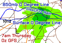
It's a real sticky situation as you can gather from my comments above. Since just a few miles will make a difference during this Wednesday/Thursday event, snow, sleet, and freezing rain amounts will vary wildly across Kentuckiana. I'll have an update tomorrow with more specifics and hopefully the computer models will have a better handle on this storm by then.
Check out some video that I shot of today's snow accumulations in Louisville below:
Be sure to select either 720p or 1080p and play at fullscreen for a high-definition experience.
Friday, December 10, 2010
12/10 - 12:30pm - Crazy Weather on the Way in Louisville!

The Latest
 The computer forecast models have had a very difficult time trying to forecast this weekend's storm across the Upper Midwest and Ohio Valley. Earlier this week there were vast differences in where the low pressure center of this storm would track. Some models had the low moving into central Tennessee or central Kentucky before cutting northward to Ohio/West Virginia, and others had it moving into Wisconsin, Illinois, and Indiana before cutting north to the Great Lakes. The Tennessee/Kentucky track is the one that would give Louisville a snowstorm, but it appears a more northerly track will take place. The HPC's (Hydrometeorological Prediction Center) depiction of the northern track is on the right image. Luckily, for you snowlovers out there, this is not the end of our snow chances for this storm here in Kentuckiana!
Here's what the National Weather Service in Louisville says about all of this:
THE COLD FRONT LOOKS TO PUSH THROUGH THE AREA SATURDAY EVENING BEFORE MIDNIGHT OVER MOST LOCATIONS. DEPENDING ON HOW FAST THE COLD AIR CAN CATCH UP TO THE PRECIP...THERE MAY BE A BRIEF CHANGE OVER TO SNOW ESPECIALLY IN THE BLUEGRASS BEFORE WE GET INTO A BRIEF DRY SLOT EARLY SUNDAY MORNING. WRAP AROUND LIGHT SNOW WILL THEN PUSH THROUGH THE AREA ON SUNDAY. LAKE ENHANCED LIGHT SNOW WILL CONTINUE SUNDAY NIGHT THROUGH MONDAY BECOMING MORE CONFINED TO OUR SOUTHEAST INDIANA COUNTIES AND THE BLUEGRASS BY MONDAY AS MOISTURE SLOWLY PULLS AWAY FROM THE REGION. TOTAL SNOW ACCUMS LOOK TO BE BETWEEN 1-3 INCHES FROM SAT NIGHT THROUGH MONDAY WITH THE HIGHEST ACCUMS EXPECTED OVER SOUTHEAST INDIANA AND THE BLUEGRASS REGION.
Even though we have a general track somewhat ironed out now, there are a couple of details that could increase our snow totals. While the GFS/ECMWF (European)/NAM/CMC models all generally agree on a northern track to this storm, the UKMET model is still taking a more southerly track near the Ohio Valley. At this point I think it's an outlier solution, but nevertheless there is a sliver of a chance that the low could take a little jog southward and impact our snow totals. There's also a chance that a secondary low could form well to the south of the primary storm and the implications of that are pretty substantial on our snow totals. Chances for that look slim as well as most computer models either don't have it or get rid of it before it exits Texas. Again, these are just a couple little things to watch that could affect us if they come to fruition by some outside chance.

I'll be posting updates on my Facebook and Twitter accounts today if there are any updates.
Saturday, November 6, 2010
11/6 - 5:30pm - Chilly Morning in Jackson!
It was downright cold this morning in Jackson, TN as temperatures bottomed out at 24 degrees during our newscast. High pressure will keep skies clear and conditions dry for about the next week or so, but stormy changes are on the way as we head toward next weekend. Check out some of my weather clips from this morning's episode of Good Morning West Tennessee on ABC 7:
Friday, September 10, 2010
9/10 - 3:30pm - Here Comes a Cold Front! / WBBJ-TV
 It may have been hot and muggy, but the weather for yesterday's MSU/Auburn game was perfect by most counts. It became clear very early in the day that the small chance of rain in the forecast for the game was gone, which was very good news considering the crazy rainfall we had on Wednesday that was on everybody's mind. Showers and storms have developed to our north this afternoon where a warm front is pulling eastward and we may see some of those develop down here in Starkville as the afternoon progresses. Rain chances will be higher tomorrow compared to today with the approach of a cold front that should pass through on Sunday. I think the best chance for rain tomorrow will happen in the late afternoon hours as the heating of the day coupled with the lift from the approaching front come together over North Mississippi. Temperatures next week should only hit around 90 degrees with lower 60's for lows due to the decreased humidity behind this cold front.
Subscribe to:
Posts (Atom)