

Showing posts with label wind. Show all posts
Showing posts with label wind. Show all posts
Wednesday, April 17, 2013
4/17 - 6:35pm - Severe Weather Tomorrow in Mississippi
Monday, March 25, 2013
3/25 - 11:35pm - Weather Says January, Calendar Says March

Tuesday, January 29, 2013
1/29 - 5:45pm - Serious Severe Weather Concerns Tonight
Latest Severe Weather Updates
 A severe weather setup that we see normally in the springtime is about to unfold on this late January night across a large expanse of the Southeast. While not "unprecedented" or "once-in-a-lifetime", this outbreak is going to impact quite a few people and it's important that everyone have what they need to be prepared and safe. This post is mainly for folks in North Mississippi and West Tennessee, but you can figure out pretty well how you'll be affected if you're not in these areas by some of the maps and information below. Everyone needs to be aware of what's going on because this will be happening at a very bad time of night when even the night owls are asleep.
Fast Facts
 A MODERATE Risk of severe weather has been issued by the Storm Prediction Center for the overnight hours in West Tennessee and most of North Mississippi. Tornadoes, damaging winds, and hail are all on the table for these areas as storms move through. Even though places like the Golden Triangle in Mississippi are just outside of the Moderate Risk area I would treat this as if you were in it because these storms are going to be very, very strong still as they move through this region. Please, please, please have a weather radio or smartphone app that's armed and ready to alert you if a Tornado Warning is issued for your location tonight. This will be hitting when most people are asleep so it's a very dangerous situation.
Timing - North MS and West TN
8pm - Midnight - Small chance for some isolated storms. These would carry a tornado, wind, and hail threat.
Midnight - 2am - Slightly better chance for isolated storms, small line of storms may try to form ahead of main line.
2am - 7am - Main line of severe thunderstorms moves through. This will affect everyone. Tornadoes, severe damaging winds, and hail are a good bet during this time.
Discussion
 A line of storms stretches from the Great Lakes to Texas right now and will continue to move eastward through the evening. A few reports of severe weather have come in already from this but the main show will be overnight as this line of storms encounters a more rich environment for severe weather.
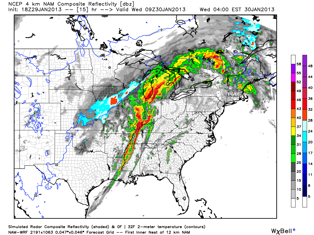 The main storm mode for tonight will be a squall line of storms with embedded rotation in portions of it (AKA what's termed a QLCS). Supercell storms will be possible ahead of the main line of storms too and could easily produce tornadoes if they develop. Tornadoes in QLCS lines of storms like the one we'll have tonight are more difficult to identify on radar since they're embedded within the line. While not as strong as supercell tornadoes, QLCS tornadoes can be strong and cause massive damage in the right environment.
 Also, since winds at 850 mb (about 5,000 feet) will be howling it will not take much for any part of this line of storms to pull these winds down to the surface and create straight-line wind damage. I wouldn't be surprised if folks affected by the worst of these winds thought they were hit by a tornado. I'm hearing the word Derecho being thrown around a bit with regard to how this system will develop tonight. That's certainly a possibility with this system but I think it's a relatively small chance.
Follow me on Twitter and my Facebook page for the latest updates tonight!
Monday, October 29, 2012
10/29 - 3:30pm - Superstorm Sandy Coming in, Cool Week in Mississippi
 Hurricane Sandy is a monster storm. That goes without saying. It's about two hours from landfall as of this writing but that won't matter much due to just how incredibly large the wind field is. Tropical storm winds extend for hundreds of miles from the center of the storm making this the largest hurricane ever recorded in the Atlantic Ocean at over 1,000 miles wide. This is big by area, not by wind speed. While the winds extend for an incredible area the winds in general are at Category 1 speeds near 90 mph. For areas in the tropics this may not sound so bad but for the Northeast this is a disaster since winds rarely get up to that strength with storms up there.
 Something that also may be unprecedented here is the extreme snow threat from Sandy for the mountainous regions of West Virginia, Virginia, North Carolina, Tennessee, and Kentucky. Snow totals could be 1 to 2 feet in places when this storm is said and done. The other thing to consider with the size and scope of this storm is the storm surge that continues to roll in. Places like New York City and along the Jersey shore could be dealing with storm surge totals in excess of 11 feet thanks to the pure mass of water that will be coming in with the storm. This will create coastal flooding whereas the high rain totals will contribute to inland flooding. You'll hear about this storm for years to come... 765,000 customers are without power across the Northeast already and this storm is just cranking up.
Saturday, October 27, 2012
10/27 - 5pm - Quiet in West Tennessee, Sandy Takes Aim


In the video below you'll get a full dose of information on Hurricane Sandy and your latest West Tennessee forecast.
Sunday, August 19, 2012
8/19 - 6pm - Tranquil Weather for the Workweek
 |
| Mississippi State University |


 |
| Click image to see a larger view |
Thursday, August 9, 2012
8/9 - 2:15pm - Severe Storm Threat Tonight


Saturday, August 4, 2012
8/4 - 2:30pm - Waking Up to Storms Tomorrow


After the front moves through on Sunday temperatures will be in the upper 80's to near 90 for the start of the workweek in Kentuckiana and storm chances will be nonexistent until Thursday.
Thursday, July 26, 2012
7/26 - 1:55pm - Kentuckiana Severe Weather Update


Thursday, June 28, 2012
6/28 - 11:30am MDT - Waking Up in Nebraska


Follow me on Twitter and Facebook for constant updates during our chase!
Monday, June 25, 2012
6/25 - 10:30am MDT - Great Faces. Great Places.


Follow me on Twitter and Facebook for the latest updates this afternoon!
Sunday, June 24, 2012
6/24 - 10:35am MDT - The Chase Begins!


Follow my continuous chase updates on my Twitter and Facebook accounts today!
Thursday, May 24, 2012
5/24 - 12:35am CDT - We're in... Iowa?


 Tomorrow will likely be a travel day back to Kansas or Southern Nebraska as we await Friday's potential chase setup. Storms tomorrow will be up near the Great Lakes in Wisconsin and Michigan and we just don't chase there due to the distance from the Plains and lack of good chase environment up there. Strong capping should keep storms from going up in the central and southern Plains, but we'll keep an eye on that in case that changes. Friday's setup may be decent if capping aloft doesn't ruin it. A deepening trough out in California and hopefully some better moisture return from the Gulf of Mexico should create potential for severe weather. A strengthening low in Southeast Colorado/Southwest Kansas should provide ample surface wind support for rotating storms should this pan out as forecast. The Storm Prediction Center already has a 5% risk area for this in their 3-day severe weather outlook. I'm crossing my fingers that this setup will yield some good storms because Friday is my last day chasing in the Plains until late June!
Follow me on Twitter and Facebook for updates this week.
Tuesday, May 22, 2012
5/21 - 11:55pm MDT - Nice LP Supercell Today
 Today didn't turn out to be the best chase, but we made the best of it with the sighting of a nice low-precipitation (LP) supercell near Grande, New Mexico. This formed within a line of discrete storm cells that stretched from Southeast Colorado to Central New Mexico. The formation of these cells in a line among an environment characterized by northwest wind flow at 18,000 feet (500 mb) didn't make for the best conditions for severe storms, but a few of them did reach severe limits. Besides this low-profile supercell and possibly a couple others in the same line, an "out of the blue" classic supercell formed ahead of an eastward-advancing MCS (mesoscale convective system - line of storms) just west of Amarillo before being ingested by the actual MCS. It didn't form in the expected environment for this, so we were not in position to see this short-lived storm. More photos of the LP supercell we saw today are available on my Flickr and Facebook albums.
Follow me on Twitter and Facebook for updates on our chase!
Sunday, May 20, 2012
5/20 - 11:45am CDT - Texas Panhandle Today


The latest updates on our chase are available on Twitter and Facebook.
Saturday, May 19, 2012
5/19 - 11:30pm CDT - New Tour Group, Chase Tomorrow

 A rash of tornadoes southwest of Wichita, Kansas near Harper has us a little down this evening since they happened during our day to switch up tour groups in Oklahoma City. Unfortunately there was damage reported with these tornadoes, which seemed to be all rope-like based on the photos being posted via social media. The rope structure of these makes sense given the low moisture in the area which means that cloud bases were high. For tomorrow the setup does not look as favorable for tornadoes given the still marginal amount of moisture in the region and weaker upper-level winds, but our sights are set on Western Oklahoma and the Panhandle region of Texas as the cold front that triggered today's madness continues southward.
 The Storm Prediction Center has a general thunderstorm risk with a 5% severe probability for the area in question tomorrow. They're not real optimistic about severe storms based on the weak upper-level and surface winds, but we'll see how that develops tomorrow. The one thing we have going is that the direction of the winds at the surface (mostly easterly) will contrast well with the mostly westerly winds at 500 mb (18,000 ft) for some directional wind shear. Good storms may be hard to come by on Monday, but as the trough that I mentioned in the previous blog post begins to move in I think our prospects will improve during the week.
Follow me on Twitter and Facebook for the latest on our chase!
Friday, May 18, 2012
5/18 - 2:45pm CDT - Regarding Next Week's Chase


Follow my storm chasing updates on Twitter and Facebook!
Subscribe to:
Posts (Atom)