Showing posts with label hurricane. Show all posts

Monday, November 5, 2012

11/5 - 2:15pm - Quick Shot of Rain on the Way in Mississippi

Showers and a few storms are moving eastward through the I-55 corridor of Central Mississippi right now. The eastern extent of these showers and storms are just about to enter Oktibbeha County and we'll keep them around until we get to midnight or so this evening. Temperatures overnight will get only into the mid 40's thanks to the rain and cloud cover, but get ready for cooler temperatures for election day tomorrow with highs near 60.

An interesting aspect of tonight's rain is that the area of low pressure associated with it will be the same one that will exit off the east coast of Florida and blow up to be a significant Nor'easter by Wednesday. This comes on the heels of Hurricane Sandy causing devastation in the Northeast so folks up there are not looking forward to the one-two punch. This Nor'easter will certainly hamper clean-up efforts but the good news is that it will not be as strong or as long-lived as Sandy.

Full sunshine will return to Mississippi by Wednesday and temperatures will recover well into the 60's to 70 or better by the weekend. We'll be watching a storm system make its way through the middle of the country next weekend that has the potential to impact us on Monday of next week. It's not entirely clear how severe the storms we'll have will be but just keep in the back of your mind that we could be off to a stormy start next week. Check out the video below for your complete forecast for the Golden Triangle area.

Monday, October 29, 2012

10/29 - 3:30pm - Superstorm Sandy Coming in, Cool Week in Mississippi

Hurricane Sandy is a monster storm. That goes without saying. It's about two hours from landfall as of this writing but that won't matter much due to just how incredibly large the wind field is. Tropical storm winds extend for hundreds of miles from the center of the storm making this the largest hurricane ever recorded in the Atlantic Ocean at over 1,000 miles wide. This is big by area, not by wind speed. While the winds extend for an incredible area the winds in general are at Category 1 speeds near 90 mph. For areas in the tropics this may not sound so bad but for the Northeast this is a disaster since winds rarely get up to that strength with storms up there.

Something that also may be unprecedented here is the extreme snow threat from Sandy for the mountainous regions of West Virginia, Virginia, North Carolina, Tennessee, and Kentucky. Snow totals could be 1 to 2 feet in places when this storm is said and done. The other thing to consider with the size and scope of this storm is the storm surge that continues to roll in. Places like New York City and along the Jersey shore could be dealing with storm surge totals in excess of 11 feet thanks to the pure mass of water that will be coming in with the storm. This will create coastal flooding whereas the high rain totals will contribute to inland flooding. You'll hear about this storm for years to come... 765,000 customers are without power across the Northeast already and this storm is just cranking up.

How is this storm affecting us here in North Mississippi? We're just seeing cooler weather thanks to the large trough of cold air that's in place. This trough is the same one that's ingesting Sandy making it a very unique storm and pulling it into the Northeast. This cooler air is going to be sticking around for the foreseeable future but with some moderation. Highs won't get out of the lower 60's tomorrow and we'll finally break into the upper 60's on Wednesday for Halloween. Overnight lows tonight will be of concern since they'll be getting close to freezing, which will create a chance for some frost. Your complete Starkville forecast with these details and more are available in the video below!

Saturday, October 27, 2012

10/27 - 5pm - Quiet in West Tennessee, Sandy Takes Aim

Ready for a REAL taste of fall? It's here.... and It's going to stick around for quite awhile. A large mass of cool air continues to work its way into West Tennessee this morning behind yesterday's cold front. That means temperatures today will be getting into the upper 50's across the region. By the time we get to late tonight and early tomorrow morning we'll be talking about mid to upper 30's for lows. Bundle up! High pressure will keep this cooler air locked in place through the week and sunshine will be plentiful as it has been in most places today. We'll need to watch for some frost in areas during the mornings starting on Monday as temperatures fall to near freezing overnight. High temperatures will slowly work their way to near 70 degrees by the end of the workweek.

Let's talk about Hurricane Sandy. It's a weak hurricane right now but the setup is more complicated than just that. As it moves toward the Northeast it will merge with a trough moving across the eastern half of the nation. This will transition the storm from a hurricane to what's called an extratropical storm. Basically this means that the storm won't feed off of warm water like a tropical system would. This will turn Sandy into the very, very large storm that its already beginning to become. Threats for wind damage, storm surge, and flooding will be possible for a broad swath of the Delmarva Peninsula through New England. New York City, Philadelphia, and Washington DC are included in this among many other locations. The storm surge issues will be amplified by the size of the storm, which moves more mass of water, and by the fact that this will be happening during a full moon, which maximizes tide. Check out the tropical storm force wind probabilities to the right... this is pretty significant when you consider there's a 60-70% of sustained tropical storm winds from Delaware to Long Island.

Another threat this storm poses is snow. West Virginia with its higher elevations will bear the brunt of the snow with 1 to 2 feet expected in areas. The latest run of the GFS model paints a very large area of 18"+ snowfall amounts through Tuesday evening. This could be crippling because there are still leaves on the trees that this heavy, wet snow will weigh down on snap limbs. Mass power outages are very likely whether you're in the wind/rain area in the Northeast or in the snow area in West Virginia.

In the video below you'll get a full dose of information on Hurricane Sandy and your latest West Tennessee forecast.

Monday, August 27, 2012

8/27 - 9:30pm - Update on Isaac's Expected Gulf Coast Landfall

Tropical Storm Isaac is teetering on the edge of becoming a hurricane this evening with winds of 70 mph as of this writing. The threshold for a Category 1 hurricane is 74 mph. The storm motion has slowed down over the past few hours, now moving northwest at only 10 mph. Issac continues to run into issues that prevent it from rapid intensification, which is certainly good news. The latest issue is a batch of dry air that is currently being pulled into the center of the storm. Without an uninhibited source of moist air the storm cannot form a defined eye or intensify very well. The dry air is why Isaac is lopsided right now with most of the intense winds on the south side.

How long will it be until this dry air is finished working through the storm? Probably a few more hours, possibly lasting into the early morning hours tomorrow if current model forecasts are correct. Speaking of models, the current track from the National Hurricane Center takes Isaac right into the Eastern Louisiana/Mississippi Coast areas late tomorrow night into early Wednesday morning as a weak Category 2 storm with 100 mph winds. With the lack of organization we're seeing right now it may only be a Category 1 at landfall. The latest computer model tracks, the spaghetti plots as you've probably heard about and seen over the past few days, have tightened up on a landfall location somewhere around New Orleans. It's worth noting that some of these models are now trending eastward after a massive amount of successive westward jogs in recent days. It doesn't appear that this landfall will take place further east than Biloxi, Mississippi given the current motion of the storm and model data, but the exact landfall location won't be the big story with this storm.


Storm surge exceedance probabilities
The big story here is how big and how slow this storm is. Sure, there will be some wind damage along the coast as the storm makes landfall, but the large area that Isaac covers means that quite an expansive area along the Gulf Coast will experience other effects from it. Storm surge at or above ten feet is possible in locations from New Orleans to Pascagoula, MS and rainfall amounts over a foot are forecast over much of Central and Southern Mississippi and Eastern Louisiana. Isaac will slow down even more than its current speed once it gets over land so heavy rain will be a good bet across much of the Gulf Coast states until we get into the weekend. Inland flooding will be a problem with the deluge that Isaac with unleash on the region as it crawls northward.

Rainfall through 7pm CDT Saturday
As far as local effects in North Mississippi and West Tennessee, Isaac will bring very heavy rain and winds with gusts in some cases near 40 mph. Starkville, MS may be looking at a six or more inch rainfall scenario through Saturday evening and areas in West Tennessee like Jackson will likely see more than three inches of rain. This highly depends on Isaac's exact track so some areas will see much more rain than others.

With just about any landfalling hurricane you can expect the threat of isolated tornadoes, and Isaac will be no different. The turning of winds with height in a hurricane or tropical storm create favorable wind shear for tornadoes to form in stronger parts of it. Due to this potential threat, the Storm Prediction Center has issued a Slight Risk for most of Mississippi and parts of Louisiana, Alabama, Georgia, and Florida.


So overall we're not looking at Isaac to be a major hurricane at landfall, but the effects from it will be widespread due to it's large size. It's a good thing that folks in a wide area are preparing for this storm since it could be a long haul given the slow motion that's expected from it.

Thursday, August 23, 2012

8/23 - 5pm - Tropics, Drought, Storms... Anything Else?

Computer model forecast tracks for Isaac
The big shakeup in the world of weather right now is the presence of Tropical Storm Isaac south of Puerto Rico. Much uncertainty still exists with where the storm will go but certainty of it making some sort of US landfall is growing. Current forecast data from multiple computer models has this storm going anywhere from the eastern Florida Peninsula to the Central Gulf over the coming days. The trend has been for these forecast tracks to shift westward over the past couple days and that means that those with interests along the Gulf Coast need to watch this storm extremely carefully. The fact that this storm may miss most of Hispanola and it's rough terrain means that we could have a stronger storm than previously expected by the time it reaches the Gulf. Once we get some better data tonight from a NOAA Gulfstream IV aircraft that is being dispatched to take measurements of the storm the model data and forecasts should improve a bit.

The 5pm EDT National Hurricane Center update on Isaac has again taken a more westerly track than before thanks to the latest model data. Their forecast has Isaac remaining a tropical storm until it clears the north side of Cuba on Monday and becomes a hurricane. This all depends on where the storm tracks because the less of Cuba and Hispanola it goes over, the more time over warm water it will have. Should the storm remain weak like it is now for a longer period, a more westerly track can be expected.


How 'bout the drought? Not much has changed from last week's drought monitor product for West Tennessee and North Mississippi. Much of West Tennessee is still suffering from a severe to exceptional drought, especially in areas near the Mississippi River and Kentucky border. The area of exceptional drought, the highest level possible, has contracted a bit since last week. Areas south of Benton County and east of Bolivar aren't faring as badly as the rest of West Tennessee, but it's worth noting that rain may be hard to come by over the next week. The worst of North Mississippi's drought is still confined to areas near Tunica and areas south of West Point don't have drought conditions at this time.


Speaking of rain, we're looking at just a small chance for some isolated showers and storms on Saturday afternoon in North Mississippi as an upper-level system moves toward us from the west. This will increase our moisture and instability a touch since winds will be turning more southerly at the surface. West Tennessee will be too far north for this storm chance unfortunately. Small storm chances will be in the forecast again as we head into the early part of the workweek, but uncertainly skyrockets after that because our weather will depend on where Isaac, by then likely a hurricane, will go. A more westerly landfall along the Gulf Coast would mean quite a bit of rain for the region while a more easterly landfall in Florida wouldn't affect us too much. This again is something we'll need to watch.

Sunday, August 19, 2012

8/19 - 6pm - Tranquil Weather for the Workweek

Mississippi State University
It's that time of year again when I switch over blog post content to cover Mississippi and West Tennessee in place of the Louisville area. I do this for two reasons: 1) It's difficult to write about the day-to-day goings on of weather back home in Louisville when I'm taking a full college course load at Mississippi State that requires me to keep up with and forecast weather for the Golden Triangle area here in Mississippi and 2) I'm convinced that it is better to forecast for the area which you are currently living in because you're always aware (sometimes painfully) of how accurate your forecast is. If anything significant happens back home in Louisville I'll be sure to include it in my posts here over the next few months, but for now I'll be covering weather down here.

While it was supposed to be a rainy day across the Golden Triangle today we actually saw quite a bit of sunshine and nice weather. A front that has become stationary over Central Mississippi put us in a much drier environment and this has cut off most of the needed moisture for showers and storms to fire up. There's still a chance that a few isolated showers and storms will get going around the region but that's a potential that will be highest during the early morning hours according to the latest short-range guidance.

The trough that's brought us the front and the cooler temperatures this weekend will continue to do so for most of the workweek as it slides slowly eastward. A lack of surface moisture and building surface high pressure will stave off rain chances and even clouds for the most part until we get close to the weekend. Temperatures this week will be gradually rising through the mid 80's for highs until we get to Thursday. By then stronger southerly flow will be bringing in warmer, moister air from the Gulf and get us back to around 90 for highs as we go through the late week and the weekend. Shower and storm chances will be returning by the weekend.

Click image to see a larger view
The tropics have been fairly quiet as of late near the US coastline but there's potential for that to change next week. A disturbed area of weather in the middle of the Atlantic Ocean is on a course that may take it toward the East Coast if the latest computer models are to be believed. It's way too early in the ballgame to discern whether or not this will be a threat to the US since it could curve back out to sea before hitting land or not strengthen into a tropical storm or hurricane. This will be something to keep a close eye on since it could become Tropical Storm Isaac.

Friday, June 1, 2012

6/1 - 9:15am - Going off the Grid

Starting this morning I will be on vacation for the next couple of weeks. I will likely not have internet access during this time so my blog and social media accounts will remain inactive until June 17th. As soon as I get back I'll be gearing up for another week of storm chasing that starts on June 23rd.

Here are a couple of weather tidbits going on today:

This is officially the first day of the Atlantic hurricane season. You wouldn't know it though because there have already been two named tropical storms Alberto and Beryl. No storms are going on in the Atlantic at this time and the forecast is for that to remain the same for at least the next couple of days.


There is a Slight Risk for severe weather over the Mid-Atlantic states today. A 10% tornado risk is in place from North Carolina to Maryland and there could be isolated supercell structures out that way during this afternoon's storms. A few high-based supercells may form in the Texas Panhandle this afternoon as well... hopefully my friends at Storm Chasing Adventure Tours can chase a few of these!

Thursday, August 25, 2011

8/25 - 4:15pm - Hurricane Irene's Fever Pitch

Hurricane Irene is certainly causing some drama both over the airwaves and along the East Coast where thousands are preparing for what could be that area's first hurricane strike in a while. This will also be the first hurricane to make landfall in the United States since Ike in 2008. States of emergency have been declared by the governors of North Carolina, Virginia, New Jersey, Maryland, and New York as the storm takes aim at the region. Areas from Wilmington, North Carolina to Cape Hatteras to Norfolk, Virginia will likely take the brunt of Irene as it makes landfall as a Category 2 or 3 storm on Saturday. A Hurricane Warning has been issued for the entire North Carolina coast and a Hurricane Watch is in effect from Virginia to New Jersey. On the satellite image to the top left you'll notice that Irene does not have a very apparent eye. This is because the storm has just completed an eyewall replacement cycle, which temporarily limits both the strength of the storm and the appearance of an eye. The eye will likely become much easier to see over the next 24 hours and the intensity of the storm will correspondingly increase.

The National Hurricane Center's 5pm EDT outlook for Hurricane Irene has the storm at Category 3 status with winds of 115 mph. For Tuesday and most of yesterday, it looked like Irene was going to miss much of the East Coast and curve back out to sea, but last night's and today's computer model runs have adjusted the storm's track quite a bit westward. This means hurricane force winds will be felt across a much larger portion of the North Carolina, Virginia coasts and even through to the Northeast and Delmarva Peninsula. To the right is a "spaghetti chart" showing all the computer model forecast tracks for Irene. There's a strong possibility that Irene may still be a Category 1 hurricane packing winds in excess of 75 mph and a storm surge up to 15 feet when it hits the New Jersey Shore, New York City, and Long Island areas on Sunday. While hurricanes that affect the Northeast aren't all that rare, the particular track of Irene and the intensity possible as it hits the area are causing great concern, especially about flooding. Folks from North Carolina to New England really need to pay attention to this storm this weekend and evacuate when instructed.

Thursday, August 4, 2011

8/4 - 11:30am - Finally, a Break in Sight!

Ridge breaking at 500mb on Wed.
The weather here in Louisville is about the same as when I left it last week on vacation in California! The good thing is that a cold front that came through yesterday will keep temperatures in the lower 90's today, as opposed to mid 90's for the last few days, and the humidity will be a little less oppressive. That said, daily afternoon storm chances will increase tomorrow and especially Saturday when an area of surface low pressure will pass right over us. That low and the accompanying cold front will finally begin the breakdown of this hot, humid ridge that we've been stuck under for so long, but not before some higher heat and humidity sneaks its way into the region for the weekend. Temperatures will be in the 80's next week as this pattern breaks, which could be temporary at best if some of the long-range models are to be believed.

So far we've had 40 days with highs at 90 or above in Louisville, with 18 consecutive days at 90 or above on our current streak. At this point last year we were counting 46 days in the 90's so far, so it seems this summer is a fairly close repeat of last.

Talk of development in the tropics has come to a fever pitch lately as Tropical Storm Emily seems to be taking a path that will pass very close to the southeast coast of Florida. The forecast path has been flip flopping around a little bit over the last couple of days, but at least right now it appears that Florida will not see a landfall from this storm. Emily has sustained winds at 50 mph, which is still a ways from the 74 mph needed to be declared a hurricane. The National Hurricane Center's forecast includes Emily reaching hurricane status by Monday well off the coast of South Carolina.

Friday, September 17, 2010

9/17 - 8pm - Super Weather Weekend!

Today was certainly fun and informative as I attended the broadcast workshop portion of the Southeast Severe Storms Symposium here at MSU. TV meteorologists James Spann (ABC 33/40 - Birmingham, AL), Mary Wasson (WTVQ - Lexington, KY), and others spoke about a range of issues pertaining to broadcast meteorology and television news. They all had great advice for the up and coming meteorology students in the audience, including yours truly. Tomorrow is the operational workshop of the symposium, which will include presentations on various weather phenomena from National Weather Service meteorologists and professors from MSU. I'll be chairing (emceeing) the symposium for a couple hours tomorrow, so it should be a lot of fun!

As if that weren't enough for tomorrow... Right after I finish chairing the symposium tomorrow afternoon, I get to jump in my car and head to Jackson, TN to begin my broadcast meteorology career at WBBJ ABC 7. My very first show will air tomorrow at 10pm CDT and I'm very, very excited to say the least. I understand that most of my blog viewers do not live close enough to Jackson to see that station, so I hope to have some video from that newscast posted here late tomorrow night or early Sunday morning. I'll also be doing the 5:30pm Sunday newscast, so I'll have a second attempt at getting some video if it doesn't work tomorrow. I do want to mention that WBBJ is available on cable from Murray, KY to Corinth, MS, so if you live within a stone's throw of West Tennessee, you may want to check your channel listings. This is not the start of my normal shift, which will start on October 2nd at 6am. I'm filling in for the weekends leading up to the premiere of the new Saturday morning show on WBBJ to get acquainted with my new position and to get introduced to the viewers. This is going to be a great experience and I know that my years of practice and preparation will pay off tomorrow.

Now that we've addressed this weekend's activities, let's talk weather! Hurricane Igor is on track towards Bermuda and is currently a Category 2 storm with winds of 105mph. Hurricane Julia is positioned to the east of Igor and is barely maintaining hurricane status at the moment. Both storms are not expected to hit the US, but Bermuda is likely to see some problems from Igor. Back closer to home, things are pretty quiet weather-wise. A cold front passed through Mississippi early this morning and brought northerly winds to the area, meaning we'll see humidity levels drop over the next couple days as that drier air filters into the region. It will likely get hot and steamy again by the end of the weekend in North Mississippi as southerly winds return. Aside from that, the rest of the week looks dry and hot as high pressure remains in control. I wouldn't expect any rain until at least next weekend, and even then it doesn't look terribly promising.

Tuesday, September 14, 2010

9/14 - 5pm - MSU Weather Forecast Video

Things are pretty stable around here in Mississippi, but we'll see a southward wind shift tomorrow as high pressure off the east coast begins to influence out weather. This will increase humidity values from Wednesday through Friday and give us some cloud cover as well. By Friday a new high pressure center will form to the northwest of the region and begin to funnel northerly air into the area that should decrease humidity and clouds for the weekend. View the entire forecast in the video below:

Saturday, September 4, 2010

9/4 - 10am - Hello from Louisville!

I'm back home in Louisville for the Labor Day weekend, which is sure to be filled with sunny skies, good food, and college football. The same cold front that came through North Mississippi yesterday came through here the day before, meaning temperatures will stay in the 70's here today with low dewpoints around the region. That front is brought pleasant weather to most of the Southeast, so go out there and enjoy it this weekend!

Hurricane Earl has now weakened into a tropical storm and is moving off toward Nova Scotia. It did not hit Cape Cod as a hurricane, which was very good news for the folks up there. There was some isolated flooding and numerous power outages, but that's about the extent of the damage in New England. North Carolina took a heavier blow from Earl, but the damage was not as significant as once feared. We turn our attention now to the remnant low of once Tropical Storm Gaston. This area of disturbed weather (marked by the red 70% circle in the NHC map) could once redevelop and turn into a storm that could affect the Caribbean and Gulf. We'll keep an eye on it.

Monday, August 30, 2010

8/30 - 7:45pm - Tropics Becoming Very Active / Calm in MS

The tropics have so-called "roared to life" over the past few days as Danielle, Earl, and Fiona have formed in the Atlantic. Danielle is no longer a hurricane and still poses no threat to land, so you can write that storm off. Hurricane Earl is the one making headlines as a Category 4 storm right now with sustained winds of 135mph. There's a chance this storm could become an ominous Category 5 storm over the next 24 hours as it nears the Outer Banks of North Carolina. There's much concern over Earl's effects on the East Coast, especially because the projected path of the storm (seen on left) has shifted closer and closer to the Outer Banks and much of New England over the past couple of days. The consensus among the various computer models (the 'spaghetti plot' to the right) is that Earl's center will stay off-shore, but it's too early to be sure about that because of the model inaccuracies and last-minute corrections that come with any storm. Should Earl track further west than anticipated, the East Coast will have quite a mess to contend with later this week. Rip currents and high waves from the storm passing offshore will be bad enough. A land falling Earl would really take things to the next level. Tropical Storm Fiona has also formed today, but it's way too early to tell if that storm will curve out to sea, hit the East Coast, or travel into the Gulf of Mexico.

Here in Mississippi we've had on and off rain over the past couple of days, but nothing all too heavy. As our air dries out from moist easterly flow from the Atlantic we've had all week, we should see a gradual decrease in clouds over the next couple days with dew points falling below 70 degrees. Our next chance of rain will happen on Friday as another cold front approaches and passes through North Mississippi. Rain chances won't be too high as the front will not have much moisture to work with as aforementioned. Don't forget to check back here tomorrow evening for my weekly MSU video weathercast!

Thursday, August 26, 2010

8/26 - 9pm - Two Words: High Pressure

If you remember anything about the forecast over the next week, remember this: High pressure will continue to keep things sunny and dry. An area of high pressure hovering near the eastern seaboard will meander around the East and Southeast over the next week, providing us with a continuation of the wonderful weather we've had here in North Mississippi over the past few days. The humid, unpleasant air that influenced our weather last week should stay south of a stationary front over the Gulf Coast. A small surface low associated with that front could produce a small chance of showers here on Friday and Saturday night, but I don't expect anything substantial. The increased moisture that will accompany this rain chance during the weekend will also bring back a small taste of humid air to the area on Saturday, but things should dry back up by Sunday and through next week. Highs will stay in the mid 90's for the next week or so, save for Monday when we'll see a brief cool-down into the mid 80's.

It's been a slow start to the Atlantic hurricane season, but things are now in high gear. We now have Hurricane Danielle, Tropical Storm Earl, and a tropical wave off the coast of Africa that will most likely become Fiona in the coming days. Neither Danielle (which is expected to become a major hurricane) nor Earl will directly impact the United States and should stay out at sea. Earl may get within a few hundred miles of the Outer Banks of North Carolina, but I don't see it getting any closer than that given the high pressure that's expected to be in place at that point in the East US. We'll keep an eye on the disturbed weather that could become Fiona to see where that tracks, but for now the US is in the clear.

Sunday, August 22, 2010

8/22 - 2:30pm - Humidity Taking a Dive / MSU Weathercasts

The heat and humidity have been relentless for the past few weeks, which is quite normal for summer here in Mississippi. While we won't be able to do anything about the heat, the humidity will at least give way somewhat over the next couple days. A cool front (you really can't call this a cold front... not one aspect of this is cold!) will drop through the Golden Triangle tonight and lower our dew points for the next week or so. These lower dew points will do two things for us: 1) Decrease the oppressive humidity in the daytime and 2) help temperatures at night drop below 70 degrees. The decrease in humidity during the hottest part of the day is a big deal because heat index values will be considerably lower than last week. Our overnight lows will dip because a decrease in air moisture (A.K.A. lower humidity) means that the air won't be able to retain heat at night and temperatures should fall into the 60's for lows. So even though we won't shake off the mid-90 temperatures with this front, the drop in humidity will do wonders for our overnight temperatures and daytime heat index values. High pressure in place across the Eastern US should keep us dry this week.

Tropical Depression Six has formed in the Atlantic and could become a hurricane by Wednesday. Winds right now are at 35mph and it's moving northwest at around 12mph. I really don't think this storm will hit the US and should curve back out to sea before it gets near to land. It's too early to say that definitively, but I think it's a good bet right now.


My Mississippi State University video forecasts return to this blog on Tuesday evening! Like last year, I'll be posting those videos every Tuesday evening as I continue to improve on my broadcasting skills. The stakes are higher this time around because I'll be putting those skills to good use in a few weeks time for something very special that will be announced soon. Like I said in the last post, this announcement will not disappoint, especially for those of you who have been following this blog for over three and a half years.

Monday, August 2, 2010

8/2 - 9am - One Last Trip to Florida!

I'm off to Orlando, Florida for one last trip this summer before I have to move back to Mississippi State for the fall semester. It may be hot and muggy down there this time of year, but it's definitely a great way to top off a great summer break. After a week there, I'll be back in Louisville for a few days before heading back to college.


There's a possibility we could run into some issues with a developing tropical system this week that's currently positioned east of the Lesser Antilles. The National Hurricane Center says there's a 90% chance of this system becoming a tropical depression and the current computer model tracks (left) are taking it into the Bahamas later this week. Should Tropical Storm or Hurricane Colin form out of this and move near the Florida Peninsula, I'll post updates on Twitter and Facebook right from Orlando. Should be a fun week down there, but hopefully we don't get soaked by a tropical system!

Thursday, July 22, 2010

7/22 - 10pm - Could We Get Another Shot at 100 Degrees?

100 degrees might not be that far off as high pressure has settled into the eastern half of the country. As it draws up warm, moist air from the south over the next couple days, temperatures and heat index values will skyrocket. The National Weather Service in Louisville has issued a Heat Advisory from noon to 7pm for both tomorrow and Saturday in lieu of the heat and humidity. Temperatures both tomorrow and Saturday could get very close to 100 degrees and even hit it in areas influenced by the urban heat island effect (like downtown Louisville and the larger suburbs). As dew points get into the lower to mid 70's, heat index values will surge past 100 or even 105 over the next couple days. In other words, be careful and stay hydrated if you have to go outside anytime soon!

Relief will come in the form of a front on Sunday, which should bring us a chance for thunderstorms until Monday morning. Temperatures will stay in the lower 90's after that with a small daily chance of rain through the remainder of the workweek.

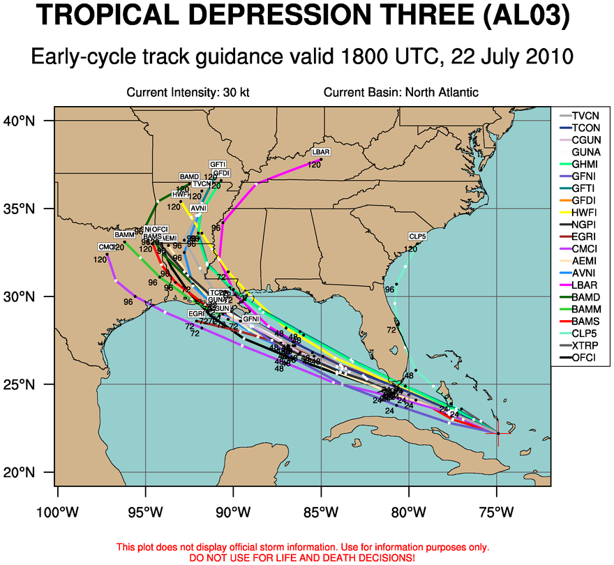
Tropical Storm Bonnie (formerly Tropical Depression Three) has formed off the coast of Florida and is expected to hit the South Florida Coast before heading out to the Gulf of Mexico. It should remain a tropical storm until it makes landfall somewhere near Louisiana according to both the National Hurricane Center and the spaghetti chart (a compilation of various computer model forecast tracks - see right image). We'll have to keep a close eye on any intensification of this storm, especially when it exits the Florida Peninsula and heads into the Gulf.

Thursday, July 1, 2010

7/1 - 5pm - Hurricane Alex Landfall / Where's the Humidity?

Hurricane Alex made landfall in Mexico last night as a category 2 storm, which was the strongest June hurricane since 1966. causing widespread damage and flooding in areas around Monterrey. Rivers that had dried up in the area became active yesterday, sweeping away cars and unfortunately people. Two have died in that area after 16 inches of rain fell from the storm, which is now a weakening tropical storm. On the US side of the border, Alex caused mainly flooding issues for areas in Texas near Brownsville. A tornado watch is in effect for South Texas until 8pm CDT as the storm weakens and moves west. Hit the links below to read more about Alex's impact on Mexico and Texas.
[Yahoo! News / KRGV-TV]

Aside from a hurricane, the other weather story of note is the lack of humidity around the Ohio Valley. In Louisville right now, the dew point is a very comfortable 49 degrees with a temperature at 82. Remember that we had dew points in the upper 60's and 70's last week, which is oppressively humid. When will the typical July heat and humidity return? It looks like July 4th is when we'll see temperatures in the 90's again with rising dew points as an area of high pressure moves to the east of us (see image on right), which will allow humid air from areas near the Gulf of Mexico to surge northward. We won't see any rain here this week as high pressure remains the dominant factor in our weather. It's pretty dry around here, so we definitely need a good soaking. A cold front will attempt to make its way through the area this time next week, so I'd say that would be our next chance of rain in Louisville.