Kentuckiana is right on the edge of what could be a significant severe weather outbreak this evening. Nothing demonstrates this better than the Storm Prediction Center's latest severe weather outlook, which puts us in a Slight Risk but has a 30% severe wind risk running right through the center of Louisville. The reason for this is that faster winds aloft are most prevalent to our north and east so more of a risk area (a Moderate Risk) is needed up there. These winds have the potential to power a large line or cluster of wind-driven storms that could possibly become a derecho just to our north if it sustains itself long enough.
A Severe Thunderstorm WATCH has gone up for areas northeast of Louisville but not including the city. This was needed because severe storms are already affecting areas near Cleveland right now and more will be forming in the near term across Ohio, West Virginia, and Pennsylvania. I suspect a Severe Thunderstorm Watch will be issued for the Louisville area at some point this evening since storms will come through a little later than areas to our north.
Storm timing in Kentuckiana should be after 5pm this evening. The latest High Resolution Rapid Refresh model has storms rolling through the Louisville Metro area at around 7pm but this may vary a bit because this will be highly dependant on where storms fire along outflow boundaries and other surface features. The HRRR suggests that these will be either a broken or continuous line of storms which makes sense given that winds both aloft and near the surface will be from a westerly direction. This also means this could be a wind-driven line of storms so wind damage potential is relatively high here if storms get severe enough. Large hail will be a threat from any of the strongest storms. There may be more than one round of storms this evening in the area through 2 or 3 am since the cold front will not be passing through until that time. This might be a good time to secure your trash cans or any loose articles you have outside your house so that they don't end up in your neighbor's yard...
A stretch of very nice quiet weather is ahead for North Mississippi after a couple days of scattered storms. Cooler temperatures filtering in behind a cold front that came through yesterday will continue to be with us until this weekend and skies will clear out even more too! These clear skies will give us some chilly temperatures tonight in the lower 40's and possibly even upper 30's. The next thing that really will happen with our weather is the approach of a system early next week that could give us clouds and eventually a chance of strong storms by late Monday into Tuesday. This chance is certainly something to keep an eye on. Check out my video at the bottom of this post for more details on this week's forecast.
Speaking of storms, the Plains has a risk of severe weather every day this week through Saturday. Persistent southwest flow aloft coupled with a few shortwave disturbances and eventually a big trough moving through later this week should trigger severe storms in quite a few locations in Tornado Alley. Right now there's a Tornado Watch out for the Texas Panhandle up through Southeast Colorado because of a stalled surface front that is providing a focus for storm development. A supercell that has popped up just north of Amarillo is providing quite a show on radar but has not put down a tornado yet according to the National Weather Service. The risks for severe weather out in that part of the nation will likely become more elevated as the bigger trough moves through later this week. In less than 24 days I'll be traveling the Plains again with Storm Chasing Adventure Tours in my 5th year of being a tour guide with them. I can't wait!
After a rainy start to the day and peeks of sunshine this afternoon, we're tracking a line of storms moving through the northern half of Mississippi. There is a Tornado Warning out for parts of Carroll and Grenada Counties due to some rotation present in that part of the storm. Severe Thunderstorm Warnings are in effect up and down this line right now, mainly for the strong wind threat they pose. The environment is not favorable for these storms to maintain their strength over the eastern half of Mississippi, so they should begin to fall apart soon.
A Severe Thunderstorm Watch is in effect for northeastern parts of Mississippi until 11pm CST:
While I do not have a full Mississippi State weather forecast today, I did record a "weather tease" in my broadcast meteorology class today. This is just a 45 second preview of a forecast that would come later in a newscast. Check it out below:
Another bout of severe weather is affecting the South as a powerful line of storms continues to push through Louisiana. These storms have spawned some tornadoes today across Louisiana and Texas while a Tornado Watch remains in effect for areas from Lake Charles, Louisiana to just south of Greenville, Mississippi. We'll be watching these storms as they track into eastern portions of Mississippi tomorrow morning. There's a chance they could be severe here in Starkville and the Golden Triangle, but the main threat should remain south of the area. Once these storms clear out we'll be left with a fantastic few days heading into the weekend. Find out more in your full forecast below:
A place that's no stranger to tornadoes was hit again early Monday morning as storms dropped ten tornadoes in Alabama. The house on your left was hit by a tornado in Trussville, which is just northeast of Birmingham. These tornadoes caused over 100 injuries and at least two deaths as they moved through the darkness. Be sure to check out NWS Birmingham's updated public information page regarding this event to see the strengths and tracks that these tornadoes took. Arkansas was also hit badly by tornadoes (at least four as damage assessments continue) and you can read a synopsis of the severe weather event in that neck of the woods from this page posted by NWS Little Rock.
West Tennessee managed to escape the brunt of this system, but the National Weather Service in Memphis is investigating an area of damage near Lexington, TN (Henderson County) for a possible tornado. They've already confirmed straight-line wind damage in both Memphis and Middleburg, TN so far. NWS Memphis also has a page where you can see their ongoing assessment of damage in the area. UPDATE 12:10am: NWS Memphis has now confirmed an EF-1 tornado in Henderson County near Lexington, TN:
5 S Lexington [Henderson Co, TN] nws storm survey reports TORNADO of F1 at 22 Jan, 11:58 PM CST -- ef1 tornado with estimated winds of 105 mph touched down 5 miles south of lexington and continued east 8 miles. numerous trees were uprooted or snapped along the path. a roof was blown off a house. a shed in the backyard was also destroyed. the tornado touched down on primarily ridge tops before eventually lifting just northeast of butterscotch road. maximum width 150 yards.
This event again underscores the need for more ways to get the warning out to folks, especially during an overnight event when people are asleep. The best way to do this is have a NOAA Weather Radio in alert mode by your bedside or to have an app on your iPhone like iMapWeather Radio. There are text-based alerting solutions offered by individual TV stations and networks too.
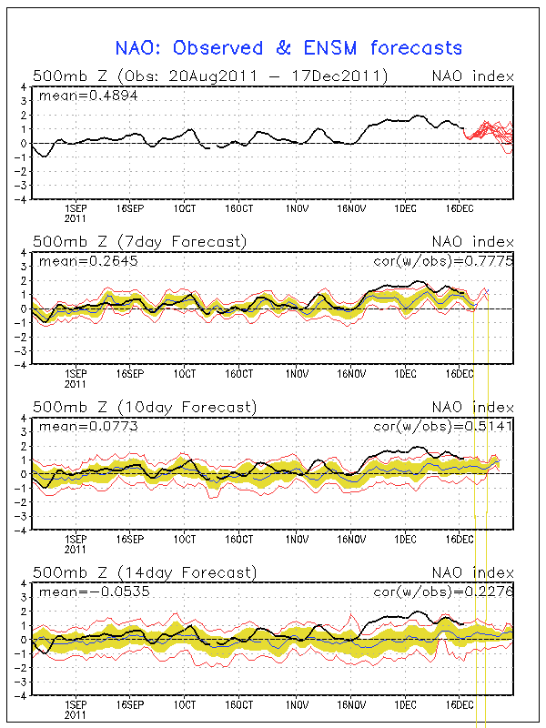
Christmas is just a week away and snow chances for many in the eastern half of the nation look pretty bleak. The next major system to pull through on Tuesday and Wednesday will produce snow in the Plains, but to the east it's expected to be all rain. A second low moving through the Deep South on Friday will bring more rain, but most of that will stay south of Kentucky and the heaviest south of Tennessee. After that point it looks pretty dry right through Christmas. Why so rainy and relatively warm lately? It has to do with the North Atlantic Oscillation, or NAO for short. When the NAO is negative, storms tend to ride up the East Coast or just west of the Appalachian Mountains. This is a recipe for snow for many across the East since these storms have cold air streaming in just to the north of their track. When the NAO is positive, storms begin deflecting northward to Canada before they reach the Mississippi River. This means that the cold air and snow with these storms stays out in the Plains. The NAO is in this positive phase right now and isn't forecast to go neutral or even negative until around the new year (see forecast and history chart to the right). Until we can get the NAO negative, I wouldn't bet on a winter storm for Kentucky, Tennessee, or much of anywhere else in the East.
23% of the United States is covered by snow at the moment, which is quite a bit lower than the 47.3% covered by snow at this time last year. Aside from Lake Effect snowcover in Pennsylvania and New York and snowcover in northern Maine, the East is snow-less.
A big winter storm is forecast to hit New Mexico, the Texas/Oklahoma Panhandles, and Kansas on Monday and Tuesday as an area of low pressure cuts northeastward (because of the positive NAO as explained above) through the Plains. A Blizzard Warning (green color on right image) has been issued for Northeast New Mexico while the other areas are under a Winter Storm Watch. Areas in the core of the snowfall north of Amarillo, TX up through Dodge City, KS could get well over a foot of snow.
West Tennessee and North Mississippi are going to be inundated with heavy rainfall starting tomorrow and lasting through Tuesday. The HPC's latest 12z rainfall forecast (right) has over 5 inches of precipitation in portions of Northwest Tennessee by the time this is all said and done, but amounts of 2 inches and over will be quite common across the area. Flooding will no doubt be a concern since this rain will fall on already saturated ground in a relatively short period of time (mostly Sunday and Monday), so the National Weather Service has issued a Flood Watch for the entirety of West Tennessee for Sunday morning through Monday night. The Tennessee and Mississippi Rivers will have to be watched during this, along with those low-lying areas that usually flood during these kinds of heavy rainfall events. After the rain and accompanying cold front move through, cooler temperatures and dry weather will be the rule for Wednesday and the remainder of the week. Check out my complete forecast on WBBJ this morning below for all the details:
Yesterday we began airing Good Morning West Tennessee for an additional hour starting at 8am. This means the Saturday show is now two hours, from 6-7am and again at 8-9am with Good Morning America airing in between. The forecast for West Tennessee still looks very wet today into tomorrow because of Tropical Storm Lee, but I think the rain should clear out as Labor Day rolls along. Check out some video from yesterday's broadcast below:
Lee is just hanging on to tropical storm status and should be downgraded to a depression later today as it moves inland. Just because it's weakening doesn't mean the risks from it will go away. Portions of Central Mississippi (I'm talking to you Starkville), Alabama, and even up through the Appalachian Mountains in North Carolina could see over eight inches of rain between now and Tuesday. Flooding is obviously a concern, so use caution while driving in these areas. Turn around, don't drown!
Tornadoes are also continuing a problem with Lee. There were 10 reports of tornadoes yesterday, some causing damage, along the Gulf Coast from Louisiana to Florida. Two tornado watches are in effect with about a half dozen warnings in them from Mississippi to Florida. The tornado risk from Lee should lessen as it continues to come onshore tonight and tomorrow.
Hurricane Irene is certainly causing some drama both over the airwaves and along the East Coast where thousands are preparing for what could be that area's first hurricane strike in a while. This will also be the first hurricane to make landfall in the United States since Ike in 2008. States of emergency have been declared by the governors of North Carolina, Virginia, New Jersey, Maryland, and New York as the storm takes aim at the region. Areas from Wilmington, North Carolina to Cape Hatteras to Norfolk, Virginia will likely take the brunt of Irene as it makes landfall as a Category 2 or 3 storm on Saturday. A Hurricane Warning has been issued for the entire North Carolina coast and a Hurricane Watch is in effect from Virginia to New Jersey. On the satellite image to the top left you'll notice that Irene does not have a very apparent eye. This is because the storm has just completed an eyewall replacement cycle, which temporarily limits both the strength of the storm and the appearance of an eye. The eye will likely become much easier to see over the next 24 hours and the intensity of the storm will correspondingly increase.
The National Hurricane Center's 5pm EDT outlook for Hurricane Irene has the storm at Category 3 status with winds of 115 mph. For Tuesday and most of yesterday, it looked like Irene was going to miss much of the East Coast and curve back out to sea, but last night's and today's computer model runs have adjusted the storm's track quite a bit westward. This means hurricane force winds will be felt across a much larger portion of the North Carolina, Virginia coasts and even through to the Northeast and Delmarva Peninsula. To the right is a "spaghetti chart" showing all the computer model forecast tracks for Irene. There's a strong possibility that Irene may still be a Category 1 hurricane packing winds in excess of 75 mph and a storm surge up to 15 feet when it hits the New Jersey Shore, New York City, and Long Island areas on Sunday. While hurricanes that affect the Northeast aren't all that rare, the particular track of Irene and the intensity possible as it hits the area are causing great concern, especially about flooding. Folks from North Carolina to New England really need to pay attention to this storm this weekend and evacuate when instructed.
The city of Louisville is recovering from an outbreak of tornadoes that even the most seasoned weather watchers didn't expect. As of this writing there have been four confirmed tornadoes (two EF-1's and two EF-2's) inside the Jefferson County/Louisville city limit. A fifth tornado in Harrison County, IN has been confirmed of EF-0 strength that started off the event. The iconic Churchill Downs received damage to barns, several power poles near the University of Louisville's Papa John's Cardinal Stadium were brought down, and buildings in Jeffersontown sustained damage along with massive tree damage as a result of three of the four tornado touchdowns in the county. Thankfully there were no reports of injuries or fatalities as these tornadoes ripped through a city containing three quarters of a million people.
Below is a rough map I've put together based on the NWS WFO Louisville storm survey page of the tornado tracks through Louisville . Purple tracks indicate EF-2 rated tornadoes (the indicated tornadoes only reached this strength briefly) and the red tracks indicate EF-1 rated tornadoes. Be sure to click the image for a larger view.
Timeline of Tornadoes
Information used in this section about each tornado can be found on NWS WFO Louisville's storm survey page.
Yesterday started off cloudy and even misting at times across the city as a cloud shield from overnight persisted well into the morning hours. The Storm Prediction Center had a Slight Risk for severe weather out for a good portion of the Mississippi and Ohio Valleys northward to Michigan, but this was a very conditional risk for Kentucky and Indiana because the cloud cover in the morning inhibited destabilization of the atmosphere. A cold front sagging southeastward from Indiana would be the trigger for any afternoon storms should they form as temperatures warmed. The clouds finally moved east of the Louisville area at around 2:30pm yesterday and temperatures topped 80 degrees by 3pm. By 6pm there were showers on the radar to the north of Louisville and a few specks on the radar to the west.
Just after 7:30pm a Tornado Warning was issued for Harrison County, IN and western portions of Jefferson County/Louisville because a tornado was spotted near Elizabeth, IN. The "storm" that triggered this warning was no more than a shower because it had no lightning strikes associated with it. I'll admit that I was skeptical of this tornado report because there was really no significant rotation on radar. I thought the report was an improper identification of moving scud clouds or even a gustnado. The storm seemed to weaken and spotters near the Shively area reported no funnel clouds, so the warning was allowed to expire. About ten minutes later the storm began to strengthen again in West Louisville and another Tornado Warning was issued just after 8pm for Jefferson County. Multiple reports of a tornado and associated damage began coming in from Churchill Downs around that time. This time the storm had lightning and the visual tornadic hook echo with prominent rotation on radar, so it was clear at this point that this thing meant business. To the right is a radar image with the supercell and hook echo near Churchill Downs and below is the velocity data with the green/red couplet signifying where the rotation was at the time. Click either image to see a larger view:
This tornado strengthened briefly into an EF-2 with 120 mph winds near the intersection of Floyd and Central Avenue at the University of Louisville campus where the power poles came down. Here's a video from YouTube user kehdsh that was posted on the WAVE 3 Weather Facebook page this afternoon. It's a little far away, but it clearly shows the funnel cloud above and debris cloud on the ground near Churchill Downs. Note that a tornado does not need to have a visible funnel snaking all the way to the ground. The debris dust-up and tube near the ground verifies that a tornado is there. Watch the center of this video closely:
The next three tornadoes to hit Louisville were actually from the same storm and you could argue that it was the same tornado that lifted and touched down three separate times. From 9:29pm to 9:41pm (a total of twelve minutes with two short breaks in between) these tornadoes pestered the Louisville incorporated city of Jeffersontown, the suburb of over 26,000 people in Jefferson
Tree on dentist office in Jeffersontown
Image: Ryan Hoke
County that I've lived on the southeastern fringe of for nearly ten years. The initial touchdown occurred in the neighborhood just behind (west of) the Meijer store on South Hurstbourne Parkway west of Jeffersontown. This is just due south of the Stonybrook Cinemas. The tornado continued eastward to downtown Jeffersontown and lifted at the St. Edward School and Church, causing EF-1 (95-100 mph winds) damage along the path. It dropped again just east of the school and went on to cause tree damage at Tully Elementary School and structural damage at an apartment complex and the Good Samaritan Center in downtown Jeffersontown. The Good Samaritan Center had EF-2 winds of 115 mph that tossed and flipped cars about 20 yards. The tornado then went on to cause significant damage at the industrial park just east of Jeffersontown before lifting again. It sat down again in the industrial park causing more warehouse damage and continued on toward the Gene Snyder Freeway (I-265) where it lifted just after damaging a bed and breakfast on Tucker Station Road. This storm wasn't as well-defined on radar as the Churchill Downs supercell because of the merger of multiple storms in the county. The embedded supercell structure with rotation was certainly there as you'll see with the red/green boundary of wind velocities north of the Jeffersontown dot in the image below:
Why it Happened
Caution: This section gets a little technical on the meteorology side of things. I explain why I think tornadoes hit Louisville unexpectedly and in such a small area.
Nobody expected this rash of tornadoes in Louisville at all. This includes the National Weather Service, local media, and me. In my blog post yesterday morning I even stated: "The tornado risk for [Southern Indiana, Kentucky, and Tennessee] will be quite low." The Storm Prediction Center issued a Slight Risk with a 2% tornado risk area in the morning with mention of wind-driven linear storms possible across the Lower Ohio Valley. Later on in the day they issued a Mesoscale Discussion that indicated they may issue a Severe Thunderstorm Watch for a broad area from Cincinnati to Memphis if storms developed more, but they never did. Some folks are asking why they didn't issued a Tornado Watch as soon as the storms unexpectedly began producing a spotter-confirmed tornado in Central Louisville, especially when the tornado threat dragged on for roughly an additional two and a half hours. My guess is that the very small lead time they would give with the issued watch and the unknown end time for this already unexpected tornado outbreak led them to scrub any plans of issuing one. Not to mention that the watch would be extremely small given that tornadoes occurred across two counties. The National Weather Service office in Louisville did a very good job of handling all the reports and translating that information into warnings for folks in the path of these storms.
These storms formed in a highly speed-sheared environment meaning winds were very fast aloft, but much slower at the surface. The direction of the winds at the surface were forecast to be from the southwest according to most of the computer forecast models. Aloft at 18,000 ft the winds were forecast to be from about the same direction, but slightly more west. This means that there was little directional shear forecast, meaning the chances of storms rotating were slim. The setup was more favorable for damaging straight-line winds. Here's where things get interesting. At 2:43pm, surface observations showed southwest winds in Louisville as forecast. All is well, but watch that southerly wind vector (down-pointing flag) east of Evansville, IN in the top picture on the left. Just before 5pm this southerly surface wind vector is in Louisville as a south-southeast wind. This increased directional shear between the surface and 18,000 ft quite a bit. The timing also lines up with the development of small showers just to our west and north. The surface winds were from the south in Jefferson County between 5pm and just before 10pm. In between these times we had the tornado pandemonium in Louisville. The timing and location is just too perfect for these southerly winds to not be a contributing factor to this event. Low-level wind shear (the kind that produces tornadoes) would have been much higher in Jefferson County than the surrounding area with the surface wind out of the south given the winds aloft being from the southwest.
It's also interesting to note that the bulk shear output on SPC's mesoscale analysis had a 50 kt maximum right over Central Kentucky and Southern Indiana. I make no claim of being a research meteorologist, but this surface wind reasoning comes from my four years of chasing storms in the Plains and the experience I've gained from books on severe weather.
The RUC and NAM models yesterday morning did pick up on the fact that storms would indeed form in the afternoon near Louisville after the clouds cleared. The 12z RUC yesterday in particular seemed to pick out the linear nature of the storms that were to form less than twelve hours later. It was nowhere near perfect, but the timing and shape of the storms were in the ballpark. Check out the comparison of a live radar capture late last night and the aforementioned RUC reflectivity (simulated radar) output:
Finally, I wanted to point out that this all happened with less than 1500 J/kg of CAPE or instability. Usually you need a little more instability than that to get severe storms going, but I think the directional wind shear compensated for that. None of the other storms outside of the localized southerly winds around Louisville were severe. That plus the fact that we had a tornado touch down in Harrison County, IN (just west of Louisville) with little to no lightning present in the storm makes this a once-in-a-lifetime event that could have been much worse if people did not heed warnings. I'm extremely pleased that there were no reports of injuries or fatalities with these five tornadoes yesterday. Hopefully this event will be the last major population center to be hit by a tornado this year, which has seen tornadoes hit cities including Tuscaloosa, Birmingham, Joplin, MO, Oklahoma City, Springfield, MA, and now Louisville, KY.
Check out NWS WFO Louisville's storm survey page for more information on this tornado event.
Severe weather has fired up across Kentucky, Indiana, and Tennessee this evening. A new Severe Thunderstorm Watch has been issued that includes Louisville and Bowling Green, KY as storms that have fired to the west of these cities have gone severe. Storms north of Evansville, IN could hit the Louisville area this evening, but they will have to fight the loss of heat that they'll encounter once the sun goes down. Severe thunderstorm warnings are being issued for the big complex of storms in Middle and Southwest Tennessee, but nothing greatly impressive is happening down that way.
The Storm Prediction Center has extended today's Slight Risk area northward as the warm sector between the warm front and cold front where these storms are setting up has moved further north. I don't think we'll be dealing with a tornado problem from these storms, but some brief and benign upper-level rotation is possible. Hail, high wind, and heavy rain should be the main threats as they develop and move through Southern Indiana and Kentucky. The storm threat should subside before midnight in these areas.
A warm front positioned over North Mississippi and Alabama is causing quite a bit of severe weather in the central parts of each state. Tornado Warnings are being issued for East Alabama, but nothing has been posted for Mississippi yet as storms haven't developed in this region. The atmosphere over Central Mississippi is very unstable at the moment and all we're waiting for is the cap (warm layer of air above the surface) to break, which will trigger some explosive storm development. There's no telling exactly when that will happen, but a good bet would be before nightfall. In any case, a Tornado Watch is posted for counties from Jackson to Tupelo, MS until 10pm tonight.
West Tennessee Forecast
A few strong storms passed through West Tennessee early this morning, but those dissipated just before the 6am hour. Storms are still ongoing in the region, but none are severe and no severe weather is expected. Storms should taper off tonight and cloudy skies will greet West Tennesseans tomorrow morning with temperatures in the 50's. More storms are possible on Tuesday. Check out my complete ABC 7 forecast in the video below:
A day makes quite a difference when it comes to winter storm forecasting, and boy do we have some changes in the forecast to talk about. The major US-based computer models, the GFS and NAM, have both trended colder and wetter in today's runs compared to yesterday. Instead of talking about ice problems in Starkville and the Golden Triangle, we're now talking heavy snow. Jackson, TN has also seen a bump in snow totals on the models, with 2-4" now possible in the Hub City.
Jackson, TN While no Winter Storm Watch is in effect for the Jackson area, snow totals could reach 2-4" by Monday midday. While this won't be a very heavy snowfall, it'll certainly cause travel problems across West Tennessee. The snow totals will increase as you head toward the Mississippi border, where up to 5 inches is possible. As you'll see in the graphic to the right, Winter Storm Watches begin with the Tennessee counties bordering Mississippi and go all the way south to just north of the Gulf Coast. I saw earlier this evening that brine has been applied to many roads across West Tennessee and that's certainly good news for travelers in the region on Sunday into Monday. I'll have the latest forecast for Jackson and West Tennessee tomorrow morning at 6am on WBBJ ABC 7's Good Morning West Tennessee!
Here's what the National Weather Service in Memphis has to say about this system:
GIVEN ALL OF THIS...IT SEEMS BEST TO CONTINUE WITH AROUND AN INCH NORTH OF JONESBORO TO PARIS...3 TO 4 INCHES ALONG AND SOUTH OF I-40...AND 5 TO 8 INCHES ACROSS MUCH OF NORTHERN MISSISSIPPI. DESPITE SOME HIGHER QPF SOUTH OF OXFORD AND TUPELO...WILL NOT PUSH TOTALS ABOVE 8 INCHES FOR NOW. LATER FORECASTS WILL CONTINUE TO FINE TUNE THESE TOTALS AS HOPEFULLY BETTER MODEL OUTPUT BECOMES AVAILABLE.
Starkville, MS The shift from a couple inches of snow with ice accumulations to heavy snow accumulations of 4-8" in Starkville by Monday morning on the computer models has been remarkable today. Colder temperatures in the mid levels of the atmosphere and increased precipitation totals have really bumped up the snow totals across the Golden Triangle and I think this is a much better solution than an ice storm in the area. Unfortunately, that risk has shifted to Central Mississippi just south of Macon, MS and power outages and tree damage could be an issue down there. The most ambitious computer model today has been the 18z NAM run (on left), which gave Starkville over 9 inches of snow. I don't think we'll get quite that much snow, but the National Weather Service's 4-8" forecast looks on-par with what I'm thinking at this point. This will be the largest snow storm in quite a few years should this pan out, so get ready for some significant travel issues in North and Central Mississippi on Sunday night and Monday. I'll keep watch on the latest model runs and post tomorrow with the latest updates!
Here's what the National Weather Service in Jackson, MS says about Mississippi's winter weather chances:
AS FAR AS PRECIPITATION TYPE...MODEL SOUNDINGS AND SREF OUTPUT GENERALLY SUPPORT PRIMARILY SNOW...PERHAPS MIXED AT TIMES WITH SLEET AND A LITTLE FREEZING RAIN...ALONG AND N OF A BASTROP LA TO MACON LINE. GIVEN THE FORECAST QPF...THIS WOULD RESULT IN ABOUT 4 TO 8 INCHES OF SNOW ACCUMULATION IN THIS AREA. ACROSS THE I-20 CORRIDOR...A FULL WINTRY MIX OF SNOW...SLEET AND FREEZING RAIN LOOKS TO BE POSSIBLE AT THIS POINT. DEPENDING ON WHAT THE DOMINANT PCPN TYPE ENDS UP BEING...THIS COULD RESULT IN SEVERAL INCHES OF SNOW...A COUPLE OF INCHES OF SLEET...OR A SIGNIFICANT LAYER OF GLAZE. ALONG THE HIGHWAY 84 CORRIDOR...PRECIP LOOKS TO POTENTIALLY BEGIN AS SNOW/SLEET THEN TRANSITION TO A MIX OF SLEET...FREEZING RAIN AND RAIN WITH SOME WINTRY ACCUMULATIONS POSSIBLE. ALL OF THESE AREAS WILL BE UNDER A WINTER STORM WATCH FROM 6 AM SUN TO 6 AM MON PER COORDINATION WITH SURROUNDING OFFICES.
Don't forget that you can follow my up-to-the minute weather updates on my Facebook and Twitter accounts.
The onset of Louisville's first major mixed precipitation winter storm of the season is just hours away and the forecast is still very difficult. The National Weather Service has extended tonight's and tomorrow's Winter Storm Warning to counties in Southern Indiana that were previously only in an advisory. The reason for this is the increase in precipitation totals that both the NAM and GFS have been hinting at today. Those areas in Indiana will see all snow and sleet, with accumulations up to six inches in places.
Here in Louisville the snow should start from the southwest near the 10pm hour and possibly mix with sleet before 1am, with accumulations of around 1-2". Based on the model guidance I've seen, I think we'll switch over to a period of sleet with some freezing rain mixed in after 1am. Freezing rain will become dominant in Louisville just a couple hours after that and last until around 7am with ice accumulations ranging from 0.25" to 0.5". The 18z GFS model (pictured top left) and the NAM both keep Louisville just below freezing at the surface during the entirety of the winter storm, but we're going to have to watch that. The snow we have on the ground will influence the surface temperatures across the area, so the computer models may be running too warm at this point. As I've said before, Downtown Louisville could get a degree or two above freezing during the afternoon and that will help road conditions improve tremendously. The 18z NAM BUFKIT output (second image on left) gives Louisville 1.7" of snow/sleet with a half inch of ice accumulation.
Even with all of this data nothing is set in stone. The storm is forming to our west right now and we're already seeing light snow and sleet falling to our west and southwest. Watching the radar trends and surface observations overnight (called nowcasting) will be crucial to see who gets what kind of precipitation. Louisville is historically the battleground between precipitation types and we'll be in that situation for sure tonight. The HPC (Hydrometeorological Prediction Center) has Louisville and areas south in a Moderate Risk for 0.25" of ice accumulation. Louisville and points north have been put under a Moderate Risk for 4"+ of snow accumulation as well, so we may very well end up with quite a bit of both snow and ice here in the city.
Should this system shift south just a few miles, Louisville would end up with mostly snow and accumulations would pile up to nearly half a foot. I've posted the 12z NAM snow accumulation output on the left just so you can see how incredibly close the heavy snow will be to Louisville, at least according to that model run. A shift northward would severely limit snow accumulations and put us in a mostly ice situation. Either way, Kentuckiana is set to get walloped by winter weather tonight. This will not be as bad as the January 2009 ice storm due to lesser ice accumulations and the potential for slightly above freezing temperatures during the daytime hours in Downtown Louisville and areas south of town as well. We'll see how it all plays out!


 Speaking of storms, the Plains has a risk of severe weather every day this week through Saturday. Persistent southwest flow aloft coupled with a few shortwave disturbances and eventually a big trough moving through later this week should trigger severe storms in quite a few locations in Tornado Alley. Right now there's a Tornado Watch out for the Texas Panhandle up through Southeast Colorado because of a stalled surface front that is providing a focus for storm development. A supercell that has popped up just north of Amarillo is providing quite a show on radar but has not put down a tornado yet according to the National Weather Service. The risks for severe weather out in that part of the nation will likely become more elevated as the bigger trough moves through later this week. In less than 24 days I'll be traveling the Plains again with Storm Chasing Adventure Tours in my 5th year of being a tour guide with them. I can't wait!

 Another bout of severe weather is affecting the South as a powerful line of storms continues to push through Louisiana. These storms have spawned some tornadoes today across Louisiana and Texas while a Tornado Watch remains in effect for areas from Lake Charles, Louisiana to just south of Greenville, Mississippi. We'll be watching these storms as they track into eastern portions of Mississippi tomorrow morning. There's a chance they could be severe here in Starkville and the Golden Triangle, but the main threat should remain south of the area. Once these storms clear out we'll be left with a fantastic few days heading into the weekend. Find out more in your full forecast below:


 When the NAO is positive, storms begin deflecting northward to Canada before they reach the Mississippi River. This means that the cold air and snow with these storms stays out in the Plains. The NAO is in this positive phase right now and isn't forecast to go neutral or even negative until around the new year (see forecast and history chart to the right). Until we can get the NAO negative, I wouldn't bet on a winter storm for Kentucky, Tennessee, or much of anywhere else in the East.


 Hurricane Irene is certainly causing some drama both over the airwaves and along the East Coast where thousands are preparing for what could be that area's first hurricane strike in a while. This will also be the first hurricane to make landfall in the United States since Ike in 2008. States of emergency have been declared by the governors of North Carolina, Virginia, New Jersey, Maryland, and New York as the storm takes aim at the region. Areas from Wilmington, North Carolina to Cape Hatteras to Norfolk, Virginia will likely take the brunt of Irene as it makes landfall as a Category 2 or 3 storm on Saturday. A Hurricane Warning has been issued for the entire North Carolina coast and a Hurricane Watch is in effect from Virginia to New Jersey. On the satellite image to the top left you'll notice that Irene does not have a very apparent eye. This is because the storm has just completed an eyewall replacement cycle, which temporarily limits both the strength of the storm and the appearance of an eye. The eye will likely become much easier to see over the next 24 hours and the intensity of the storm will correspondingly increase.


 This time the storm had lightning and the visual tornadic hook echo with prominent rotation on radar, so it was clear at this point that this thing meant business. To the right is a radar image with the supercell and hook echo near Churchill Downs and below is the velocity data with the green/red couplet signifying where the rotation was at the time. Click either image to see a larger view:


 where it lifted just after damaging a bed and breakfast on Tucker Station Road. This storm wasn't as well-defined on radar as the Churchill Downs supercell because of the merger of multiple storms in the county. The embedded supercell structure with rotation was certainly there as you'll see with the red/green boundary of wind velocities north of the Jeffersontown dot in the image below:

 Nobody expected this rash of tornadoes in Louisville at all. This includes the National Weather Service, local media, and me. In my blog post yesterday morning I even stated: "The tornado risk for [Southern Indiana, Kentucky, and Tennessee] will be quite low." The Storm Prediction Center issued a Slight Risk with a 2% tornado risk area in the morning with mention of wind-driven linear storms possible across the Lower Ohio Valley. Later on in the day they issued a Mesoscale Discussion that indicated they may issue a Severe Thunderstorm Watch for a broad area from Cincinnati to Memphis if storms developed more, but they never did. Some folks are asking why they didn't issued a Tornado Watch as soon as the storms unexpectedly began producing a spotter-confirmed tornado in Central Louisville, especially when the tornado threat dragged on for roughly an additional two and a half hours. My guess is that the very small lead time they would give with the issued watch and the unknown end time for this already unexpected tornado outbreak led them to scrub any plans of issuing one. Not to mention that the watch would be extremely small given that tornadoes occurred across two counties. The National Weather Service office in Louisville did a very good job of handling all the reports and translating that information into warnings for folks in the path of these storms.

 These storms formed in a highly speed-sheared environment meaning winds were very fast aloft, but much slower at the surface. The direction of the winds at the surface were forecast to be from the southwest according to most of the computer forecast models. Aloft at 18,000 ft the winds were forecast to be from about the same direction, but slightly more west. This means that there was little directional shear forecast, meaning the chances of storms rotating were slim. The setup was more favorable for damaging straight-line winds. Here's where things get interesting. At 2:43pm, surface observations showed southwest winds in Louisville as forecast. All is well, but watch that southerly wind vector (down-pointing flag) east of Evansville, IN in the top picture on the left. Just before 5pm this southerly surface wind vector is in Louisville as a south-southeast wind. This increased directional shear between the surface and 18,000 ft quite a bit. The timing also lines up with the development of small showers just to our west and north. The surface winds were from the south in Jefferson County between 5pm and just before 10pm. In between these times we had the tornado pandemonium in Louisville. The timing and location is just too perfect for these southerly winds to not be a contributing factor to this event. Low-level wind shear (the kind that produces tornadoes) would have been much higher in Jefferson County than the surrounding area with the surface wind out of the south given the winds aloft being from the southwest.


 Severe weather has fired up across Kentucky, Indiana, and Tennessee this evening. A new Severe Thunderstorm Watch has been issued that includes Louisville and Bowling Green, KY as storms that have fired to the west of these cities have gone severe. Storms north of Evansville, IN could hit the Louisville area this evening, but they will have to fight the loss of heat that they'll encounter once the sun goes down. Severe thunderstorm warnings are being issued for the big complex of storms in Middle and Southwest Tennessee, but nothing greatly impressive is happening down that way.

 While no Winter Storm Watch is in effect for the Jackson area, snow totals could reach 2-4" by Monday midday. While this won't be a very heavy snowfall, it'll certainly cause travel problems across West Tennessee. The snow totals will increase as you head toward the Mississippi border, where up to 5 inches is possible. As you'll see in the graphic to the right, Winter Storm Watches begin with the Tennessee counties bordering Mississippi and go all the way south to just north of the Gulf Coast. I saw earlier this evening that brine has been applied to many roads across West Tennessee and that's certainly good news for travelers in the region on Sunday into Monday. I'll have the latest forecast for Jackson and West Tennessee tomorrow morning at 6am on WBBJ ABC 7's Good Morning West Tennessee!
 The shift from a couple inches of snow with ice accumulations to heavy snow accumulations of 4-8" in Starkville by Monday morning on the computer models has been remarkable today. Colder temperatures in the mid levels of the atmosphere and increased precipitation totals have really bumped up the snow totals across the Golden Triangle and I think this is a much better solution than an ice storm in the area. Unfortunately, that risk has shifted to Central Mississippi just south of Macon, MS and power outages and tree damage could be an issue down there. The most ambitious computer model today has been the 18z NAM run (on left), which gave Starkville over 9 inches of snow. I don't think we'll get quite that much snow, but the National Weather Service's 4-8" forecast looks on-par with what I'm thinking at this point. This will be the largest snow storm in quite a few years should this pan out, so get ready for some significant travel issues in North and Central Mississippi on Sunday night and Monday. I'll keep watch on the latest model runs and post tomorrow with the latest updates!
 The onset of Louisville's first major mixed precipitation winter storm of the season is just hours away and the forecast is still very difficult. The National Weather Service has extended tonight's and tomorrow's Winter Storm Warning to counties in Southern Indiana that were previously only in an advisory. The reason for this is the increase in precipitation totals that both the NAM and GFS have been hinting at today. Those areas in Indiana will see all snow and sleet, with accumulations up to six inches in places.
 Here in Louisville the snow should start from the southwest near the 10pm hour and possibly mix with sleet before 1am, with accumulations of around 1-2". Based on the model guidance I've seen, I think we'll switch over to a period of sleet with some freezing rain mixed in after 1am. Freezing rain will become dominant in Louisville just a couple hours after that and last until around 7am with ice accumulations ranging from 0.25" to 0.5". The 18z GFS model (pictured top left) and the NAM both keep Louisville just below freezing at the surface during the entirety of the winter storm, but we're going to have to watch that. The snow we have on the ground will influence the surface temperatures across the area, so the computer models may be running too warm at this point. As I've said before, Downtown Louisville could get a degree or two above freezing during the afternoon and that will help road conditions improve tremendously. The 18z NAM BUFKIT output (second image on left) gives Louisville 1.7" of snow/sleet with a half inch of ice accumulation.

 Even with all of this data nothing is set in stone. The storm is forming to our west right now and we're already seeing light snow and sleet falling to our west and southwest. Watching the radar trends and surface observations overnight (called nowcasting) will be crucial to see who gets what kind of precipitation. Louisville is historically the battleground between precipitation types and we'll be in that situation for sure tonight. The HPC (Hydrometeorological Prediction Center) has Louisville and areas south in a Moderate Risk for 0.25" of ice accumulation. Louisville and points north have been put under a Moderate Risk for 4"+ of snow accumulation as well, so we may very well end up with quite a bit of both snow and ice here in the city.
 Should this system shift south just a few miles, Louisville would end up with mostly snow and accumulations would pile up to nearly half a foot. I've posted the 12z NAM snow accumulation output on the left just so you can see how incredibly close the heavy snow will be to Louisville, at least according to that model run. A shift northward would severely limit snow accumulations and put us in a mostly ice situation. Either way, Kentuckiana is set to get walloped by winter weather tonight. This will not be as bad as the January 2009 ice storm due to lesser ice accumulations and the potential for slightly above freezing temperatures during the daytime hours in Downtown Louisville and areas south of town as well. We'll see how it all plays out!