

Showing posts with label tennessee. Show all posts
Showing posts with label tennessee. Show all posts
Tuesday, February 5, 2013
2/5 - 10:30pm - Dense Fog Tonight
Tuesday, January 29, 2013
1/29 - 5:45pm - Serious Severe Weather Concerns Tonight
Latest Severe Weather Updates
 A severe weather setup that we see normally in the springtime is about to unfold on this late January night across a large expanse of the Southeast. While not "unprecedented" or "once-in-a-lifetime", this outbreak is going to impact quite a few people and it's important that everyone have what they need to be prepared and safe. This post is mainly for folks in North Mississippi and West Tennessee, but you can figure out pretty well how you'll be affected if you're not in these areas by some of the maps and information below. Everyone needs to be aware of what's going on because this will be happening at a very bad time of night when even the night owls are asleep.
Fast Facts
 A MODERATE Risk of severe weather has been issued by the Storm Prediction Center for the overnight hours in West Tennessee and most of North Mississippi. Tornadoes, damaging winds, and hail are all on the table for these areas as storms move through. Even though places like the Golden Triangle in Mississippi are just outside of the Moderate Risk area I would treat this as if you were in it because these storms are going to be very, very strong still as they move through this region. Please, please, please have a weather radio or smartphone app that's armed and ready to alert you if a Tornado Warning is issued for your location tonight. This will be hitting when most people are asleep so it's a very dangerous situation.
Timing - North MS and West TN
8pm - Midnight - Small chance for some isolated storms. These would carry a tornado, wind, and hail threat.
Midnight - 2am - Slightly better chance for isolated storms, small line of storms may try to form ahead of main line.
2am - 7am - Main line of severe thunderstorms moves through. This will affect everyone. Tornadoes, severe damaging winds, and hail are a good bet during this time.
Discussion
 A line of storms stretches from the Great Lakes to Texas right now and will continue to move eastward through the evening. A few reports of severe weather have come in already from this but the main show will be overnight as this line of storms encounters a more rich environment for severe weather.
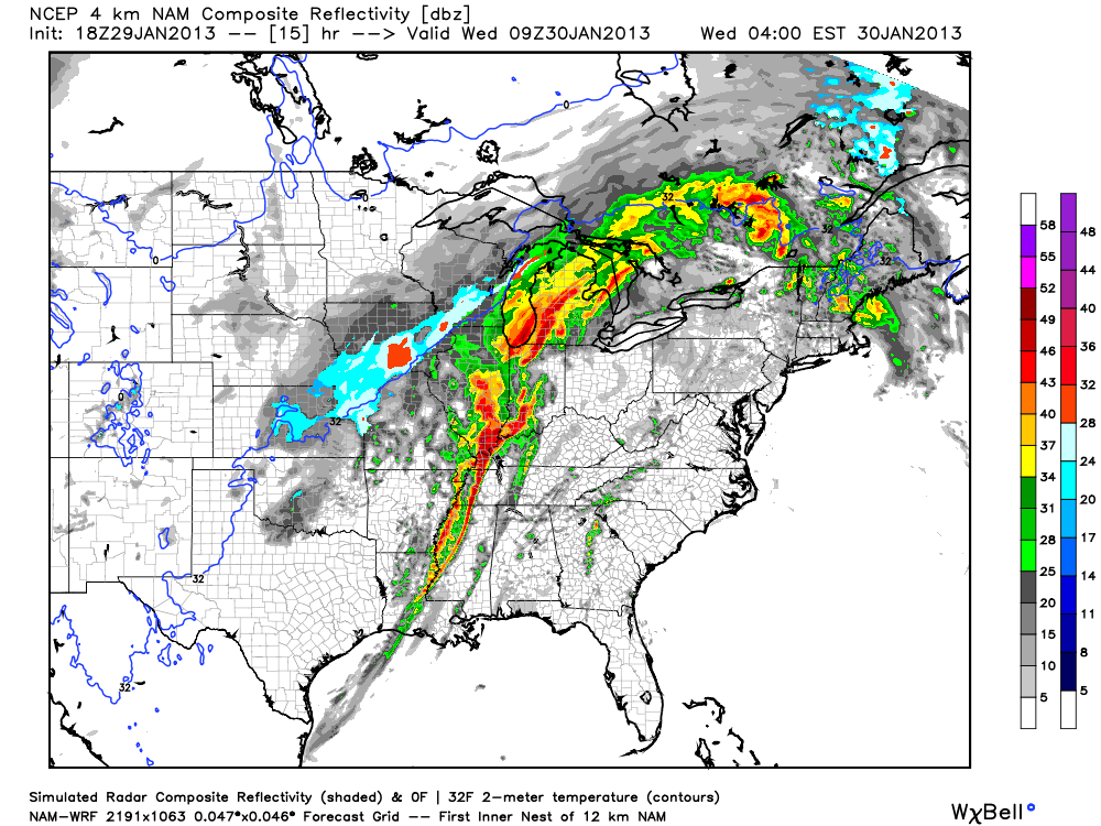 The main storm mode for tonight will be a squall line of storms with embedded rotation in portions of it (AKA what's termed a QLCS). Supercell storms will be possible ahead of the main line of storms too and could easily produce tornadoes if they develop. Tornadoes in QLCS lines of storms like the one we'll have tonight are more difficult to identify on radar since they're embedded within the line. While not as strong as supercell tornadoes, QLCS tornadoes can be strong and cause massive damage in the right environment.
 Also, since winds at 850 mb (about 5,000 feet) will be howling it will not take much for any part of this line of storms to pull these winds down to the surface and create straight-line wind damage. I wouldn't be surprised if folks affected by the worst of these winds thought they were hit by a tornado. I'm hearing the word Derecho being thrown around a bit with regard to how this system will develop tonight. That's certainly a possibility with this system but I think it's a relatively small chance.
Follow me on Twitter and my Facebook page for the latest updates tonight!
Sunday, September 16, 2012
9/16 - 2:40pm - Rainy Start to the Week in West Tennessee

If you watched the video you probably saw some changes from previous ones that I've posted. WBBJ debuted an all-new HD weather graphics system that has full 3D rendering capabilities. It's very slick, easy to use, and most of all, fun! The 3D zooms to Jackson's tonight and tomorrow forecast I built from scratch between shows yesterday and it was pretty amazing what the machine could do with so little time.
This is also my 2nd anniversary with WBBJ. A lot has changed since I started working there in September 2010 but one thing that hasn't changed is how much I enjoy doing shows there! Can't wait to keep going back there on select weekends during this school year.
Wednesday, September 5, 2012
9/5 - 11:35pm - Stormy Week, Cooler Weekend, and TV Tomorrow!


 Looking for something to do tomorrow night? On the Travel Channel at 10 pm/9c tomorrow night a show called Extreme Tours will be airing and the first segment of the show will feature me and my pals at Storm Chasing Adventure Tours! A crew from the show came out to film and interview us as we chased this past spring in New Mexico and their footage along with clips from my library of tornado video will be airing. This program will showcase what we do as a tour group and how we make it happen. Quite a few of our tour guests and tour guides were interviewed for this and the camera crew that came rode along with us for a few hours. I did a sit-down interview with them along with an extensive round of showing off our vehicles and equipment. This should be a good show tomorrow and I'm certainly looking forward to my first appearance on a non-news national TV program! If you can't make it home in time to watch tomorrow be sure to set your DVR.
Monday, August 27, 2012
8/27 - 9:30pm - Update on Isaac's Expected Gulf Coast Landfall


 How long will it be until this dry air is finished working through the
storm? Probably a few more hours, possibly lasting into the early
morning hours tomorrow if current model forecasts are correct. Speaking
of models, the current track from the National Hurricane Center takes
Isaac right into the Eastern Louisiana/Mississippi Coast areas late
tomorrow night into early Wednesday morning as a weak Category 2 storm
with 100 mph winds. With the lack of organization we're seeing right now
it may only be a Category 1 at landfall. The latest computer model
tracks, the spaghetti plots as you've probably heard
about and seen over the past few days, have tightened up on a landfall
location somewhere around New Orleans. It's worth noting that some of
these models are now trending eastward after a massive amount of
successive westward jogs in recent days. It doesn't appear that this
landfall will take place further east than Biloxi, Mississippi given the
current motion of the storm and model data, but the exact landfall
location won't be the big story with this storm.
How long will it be until this dry air is finished working through the
storm? Probably a few more hours, possibly lasting into the early
morning hours tomorrow if current model forecasts are correct. Speaking
of models, the current track from the National Hurricane Center takes
Isaac right into the Eastern Louisiana/Mississippi Coast areas late
tomorrow night into early Wednesday morning as a weak Category 2 storm
with 100 mph winds. With the lack of organization we're seeing right now
it may only be a Category 1 at landfall. The latest computer model
tracks, the spaghetti plots as you've probably heard
about and seen over the past few days, have tightened up on a landfall
location somewhere around New Orleans. It's worth noting that some of
these models are now trending eastward after a massive amount of
successive westward jogs in recent days. It doesn't appear that this
landfall will take place further east than Biloxi, Mississippi given the
current motion of the storm and model data, but the exact landfall
location won't be the big story with this storm. |
| Storm surge exceedance probabilities |
 |
| Rainfall through 7pm CDT Saturday |

So overall we're not looking at Isaac to be a major hurricane at landfall, but the effects from it will be widespread due to it's large size. It's a good thing that folks in a wide area are preparing for this storm since it could be a long haul given the slow motion that's expected from it.
Thursday, August 23, 2012
8/23 - 5pm - Tropics, Drought, Storms... Anything Else?
 |
| Computer model forecast tracks for Isaac |


How 'bout the drought? Not much has changed from last week's drought monitor product for West Tennessee and North Mississippi. Much of West Tennessee is still suffering from a severe to exceptional drought, especially in areas near the Mississippi River and Kentucky border. The area of exceptional drought, the highest level possible, has contracted a bit since last week. Areas south of Benton County and east of Bolivar aren't faring as badly as the rest of West Tennessee, but it's worth noting that rain may be hard to come by over the next week. The worst of North Mississippi's drought is still confined to areas near Tunica and areas south of West Point don't have drought conditions at this time.

Saturday, August 4, 2012
8/4 - 2:30pm - Waking Up to Storms Tomorrow


After the front moves through on Sunday temperatures will be in the upper 80's to near 90 for the start of the workweek in Kentuckiana and storm chances will be nonexistent until Thursday.
Sunday, July 22, 2012
7/22 - 10:30pm CDT - Heat Cranks Up in West Tennessee
 |
| A few showers at 3:25pm today |
My weathercast from last night's 10pm news on WBBJ in Jackson is available to watch below.
Wednesday, July 18, 2012
7/18 - 10:40pm - Storm Spotting in Your Own Front Yard


Sunday, July 15, 2012
7/15 - 7pm CDT - The Heat Returns!


Thursday, July 12, 2012
7/12 - 11:45pm - A Festive Forecast

 Tomorrow is the beginning of the Forecastle Festival at Waterfront Park in Louisville. Unfortunately rainfall could be an issue as a stationary boundary begins to move northward from North Mississippi overnight. This boundary will bring even more moisture into the area and a source of lift, the boundary itself, which should bring in some ongoing showers and storms tomorrow morning. The short-range models right now are suggesting that there may be a break in the action after 2pm, which you'll see in the NAM simulated radar image on the right. Disagreement among the models exists over whether the storms will re-fire and make an impact in the area later on in the afternoon. My thoughts on this are that storms may have trouble getting going again in the late afternoon since the morning's activity will be hanging around well into the early afternoon, but that the presence of the frontal boundary will compensate quite a bit for this. Expect then for storms to possibly re-fire and move into the area sometime after 5pm. The good news here for festival goers is that I don't think storm coverage will be quite as high during this second round, so there's a good chance the Waterfront may be able to dodge storms if they remain scattered.
Daily storm chances will continue on Saturday and Sunday as the moisture from the current system sticks around and a bit of upper-level support kicks in thanks to a trough passing through the Great Lakes region. These storm chances will be a bit lower than tomorrow's though because there won't be much of anything to trigger them, like a front, aside from daytime heating in the afternoon. Long story short, bring a rain jacket or poncho if you're going downtown for Forecastle this weekend. Temperatures will top out near 80 tomorrow as the clouds and rain move through, but it will warm into the mid 80's for the weekend in Louisville.
 Speaking of this weekend, I'm going to be a busy guy! On Saturday I'm heading down to Jackson, Tennessee to do the Saturday and Sunday evening shifts of weather at WBBJ-TV. This means you'll see me on the 6pm and 10pm newscasts this weekend if you're in the viewing area. It's been almost three months since I've done weather on TV, but I'm very excited to be getting back into it this coming weekend and again on Saturday night next weekend. Be sure to tune in!
Tuesday, July 10, 2012
7/10 - 11:55pm - A Tale of Two TV Stations
 Let's start with weather first, shall we? Today was hot in Louisville, much hotter than anticipated because dry air that made its way into the area allowed temperatures to rise quite a bit. We're talking about a high temperature that was 95 degrees today, which even though is very warm, it was still cooler than what we experienced during last week's massive heat wave. Tomorrow should be a little cooler as moister air moves in again from the south.

Saturday, April 28, 2012
4/28 - 4:45pm - Hot Weather, Fun Show at WBBJ!
 Today marks my last show at WBBJ until August when I come back from my college summer break. And boy what a fitting show it was. Of course the weather is going to be hot and muggy through next week with pretty consistent small daily storm chances (each day except Wednesday). A pesky frontal boundary sticking around the region for a few days before eventually lifting northward will be the culprit for these pop-up showers and storms. You can check out the video from this morning's weathercast below. The big show today was an interview by Myles Savage, the lead singer from the Platters, this morning on our show. He gave a fun and spirited performance that none of us in the studio will ever forget! The video of his interview is below my weathercast. Enjoy!
Just ONE WEEK until my first three weeks of storm chasing begins in the Plains!
Saturday, April 21, 2012
4/21 - 9:45pm - Cooler, but Sunny Weather Ahead!

Saturday, April 14, 2012
4/14 - 2:30pm - Nice West TN Weekend, Outbreak in the Plains
 |
| Sunday Night storms on NAM Model |
 A potent severe weather outbreak is just getting started in the Plains right now. Areas from Nebraska to Oklahoma are under a rare High Risk of severe weather from the Storm Prediction Center and violent tornadoes are expected this afternoon and evening. Already we've had quite a few reports of tornadoes touching down and doing damage in Kansas this afternoon, and more of the same can be expected as this system pulls more moisture northward and destabilization continues. On the left you'll see the latest EHI chart from the SPC, which is a measure of helicity (spinning motion in the atmosphere) and instability. This is a decent indicator of where the strongest tornadoes could form. It's really ramping up with values as high as 7 in Oklahoma right now, but those values are expected to increase and possibly move northward this afternoon and evening into Kansas and Nebraska.
Be sure and join me again on WBBJ for 7 Eyewitness News at 6 and 10pm tonight!
Saturday, April 7, 2012
4/7 - 7:15pm - Fantastic Easter Weekend

Saturday, March 31, 2012
3/31 - 3pm - Severe Risk in West Tennessee
 Storms are already popping up in Tennessee as a weak disturbance aloft is allowing the warm, moist air that we have at the surface to rise. A Severe Thunderstorm Watch is in effect for a good deal of West Tennessee until 9pm CDT tonight and the main risks from these storms should they become severe will be large hail and wind. With temperatures aloft being so cold the storms should be able to produce hail easily today. Might want to think about putting your car in a garage or carport if you have one.
 Instability is already building across the region as you'll see on the right image. Storms have not really broken out across West Tennessee yet because a weak warm layer aloft known as the "cap" is prohibiting air from rising. Once we get a degree or so warmer that cap should erode and storms will form. This will not be a tornado day because wind shear is very, very weak.
Check out my forecast from this morning on WBBJ below:
Be sure and catch me on 7 Eyewitness News again this evening at 6 and 10 o'clock!
Saturday, March 24, 2012
3/24 - 3:30pm - Another Very Warm Week Ahead

Subscribe to:
Posts (Atom)