Showing posts with label snowstorm. Show all posts

Friday, December 28, 2012

12/28 - 1:30am EST - Kentuckiana Winter Storm Number 2

Wednesday's winter storm didn't give much snow to folks in the Louisville area and instead confined heavy snow to areas of Southern Indiana. While differences in the models did exist over whether Louisville would get any accumulating snow or not, the overall situation was handled pretty well from a forecast standpoint. The highest snow report in NWS Louisville's coverage area was 7.2 inches in Washington County, IN while Louisville received a trace to a half inch.


The next storm on the heels of the last one is less than 24 hours away as a system arrives from the southwest and stays to our southeast as it moves through the region. This will start as some rain for the Louisville area but as colder air filters in we'll switch over to snow during the later evening hours. This exact time for switchover depends on how warm we get during the day tomorrow (lower 40's versus upper 30's makes a difference!) and how fast the cold air comes in. The 0z NAM that came in earlier tonight has about 3" for the city and after comparing this with other models I'm thinking this may be a number we'll see most commonly reported by Saturday morning in Louisville. Higher totals will be possible just a bit further north from Louisville.

But even as I say this there's a small fly in the ointment. The 3z RPM model is in and it has the possibility of 4-6" of snow just due east of the city and a few very small totals like this scattered throughout areas near the Ohio River. This suggests that totals closer to 4" might be more widespread than previously thought. You can click the RPM output on the left for a larger view. We've seen the trend of increasing snow totals today on the models and this run of the RPM just continues this. We'll need to watch for this trend tomorrow morning to see if other models catch on. Right now this isn't really a factor in my forecast since it's just one model. Below is my snow forecast map for the region. Realize that, like the last storm, a small shift in track or more/less cold air will change things for some folks drastically.


Also worth noting is that the Hyrdrometeorological Prediction Center (HPC) has us in a Slight Risk of a 4" snowfall (think of this like the Slight, Moderate, and High severe weather risks) while areas closer to Cincinnati are in a Moderate Risk. Expect to see Winter Weather Advisories being issued tomorrow for portions of Kentuckiana. There may also be a few Winter Storm Watches issued as well depending on if forecast amounts of 4" or more look to be more widespread. You can keep up with the latest on this storm tomorrow by following me on Twitter and Facebook. Good luck, snow lovers!

Saturday, December 17, 2011

12/17 - 11:50pm - A Not So White Christmas

Positive NAO - http://www.ldeo.columbia.edu/NAO
Christmas is just a week away and snow chances for many in the eastern half of the nation look pretty bleak. The next major system to pull through on Tuesday and Wednesday will produce snow in the Plains, but to the east it's expected to be all rain. A second low moving through the Deep South on Friday will bring more rain, but most of that will stay south of Kentucky and the heaviest south of Tennessee. After that point it looks pretty dry right through Christmas. Why so rainy and relatively warm lately? It has to do with the North Atlantic Oscillation, or NAO for short. When the NAO is negative, storms tend to ride up the East Coast or just west of the Appalachian Mountains. This is a recipe for snow for many across the East since these storms have cold air streaming in just to the north of their track. When the NAO is positive, storms begin deflecting northward to Canada before they reach the Mississippi River. This means that the cold air and snow with these storms stays out in the Plains. The NAO is in this positive phase right now and isn't forecast to go neutral or even negative until around the new year (see forecast and history chart to the right). Until we can get the NAO negative, I wouldn't bet on a winter storm for Kentucky, Tennessee, or much of anywhere else in the East.

23% of the United States is covered by snow at the moment, which is quite a bit lower than the 47.3% covered by snow at this time last year. Aside from Lake Effect snowcover in Pennsylvania and New York and snowcover in northern Maine, the East is snow-less.

A big winter storm is forecast to hit New Mexico, the Texas/Oklahoma Panhandles, and Kansas on Monday and Tuesday as an area of low pressure cuts northeastward (because of the positive NAO as explained above) through the Plains. A Blizzard Warning (green color on right image) has been issued for Northeast New Mexico while the other areas are under a Winter Storm Watch. Areas in the core of the snowfall north of Amarillo, TX up through Dodge City, KS could get well over a foot of snow.

Wednesday, November 30, 2011

11/30 - 4pm - Mid-South Winter Storm Wrap-Up

The National Weather Service in Memphis has released a snowfall map that recaps the measured snowfall totals across the Mid-South. Jackson, TN broke an all-time November snowfall record with 2.0", but note that slightly higher totals were recorded elsewhere in Madison County away from where the official observations are taken for the NWS. Look at those snowfall accumulations of over 5" in Northeast Arkansas and the Missouri Bootheel... very impressive! This was quite a rare storm and the method through which the storm produced the snow, a cut-off low that supplied its own cold air from aloft, is something that doesn't happen too often either.


The snow was even apparent on visible satellite this morning, which is amazing because temperatures were above freezing for most of yesterday:


Wintry weather should stay out of the forecast for at least the next week or so, but rain chances will be on the increase in West Tennessee early next week. The GFS computer model is hinting at the possibility of a little bit of snow late next weekend, but it's much too far out to make any predictions at this point. Certainly something to watch!

Monday, November 28, 2011

11/28 - 2:45pm - An Early Shot of Winter Weather

A complicated upper-level low is making for some difficult forecasting over the next 24 hours as it brings the first real chance of snow to the South this season. This upper-level low is basically a big bubble of cold air aloft that has been orphaned from a bigger system that has since moved away from the region. Since we still have showers in the area, this cold air will help to turn those into snow by late tonight in areas near Starkville and northward. Since temperatures at the surface here in Starkville won't make it above 34 or so, any brief period of snow we see will not stick to the ground. I do think there could be a complete changeover to snow here in Starkville tomorrow morning around 8 or 9am, but this is highly dependent upon how well the computer models handle this system. Further north near Tupelo, Memphis, and Jackson, TN there will be enough cold air to get the snow on the ground when it falls, but the vast amount of warm rain we've had lately has kept the ground warm and moist, so snow accumulations won't stick around for long. Travel hazards won't be a huge deal since the roads are still warm, but it's a good idea to keep a look out for slick spots where temperatures dip below freezing tonight. Click on the SREF model snow output to the right... I think it has the most reasonable estimate on who will get accumulating snow tonight.

A Winter Storm Watch has been issued for areas from Tupelo to McNairy County, TN until 6am tomorrow since heavier snow could result in accumulations of 3 inches or more. The Winter Weather Advisory around the periphery of the Watch is for wet snow accumulations that could total around 1 to 3 inches. The snow should end by late morning tomorrow as it converts back to rain showers and then the precipitation will clear the area completely by around noon or so.

Check out my video below for a complete look at this week's forecast in Starkville and more details about the snow that's headed our way:


This evening at 6pm is the annual Starkville Christmas Parade. I'll be doing a short weather segment for the parade broadcast on WOBV 5 in Starkville. This event will also be streamed live on the web, so be sure to check out http://parade.wobv5.com/ tonight at 6pm CST to see my forecast and enjoy the parade!

Thursday, February 10, 2011

2/10 - 1:30pm - Another Snowstorm in North Mississippi

Snow is not common in Mississippi. Really, I'm telling you it's not. That's a hard thing to believe after receiving our second heavy snowfall of the season last night here in Starkville and across the state. Locally we received 4-5" and areas to our north and west closer to Oxford and the Delta region saw amounts near 6". I'll admit that my forecast for areas east of Greenwood, MS was a bust. I settled on 2-3" a couple days ago and stuck with it based on the computer models. Even then, a lot of computer models coming in were suggesting amounts way below this and it was tough not to lower the forecast. The fact of the matter is that most forecasters, both human and computer, overestimated the amount of weakening in this storm as it moved east and it led to quite a surprise. Something that really helped up the totals locally was a quick drop in temperature to the freezing mark before 4pm. Mississippi State University decided to call off classes at the last minute this morning after previously stating they would open at 11am. Good thing... the roads and sidewalks even at 11:30am this morning weren't good at all and temperatures are still in the upper 20's at this hour. I doubt we'll get above freezing today. Check out my video compilation of the snow on campus below and flip through the slideshow below that (there are some fantastic panoramas in there!):


Tuesday, February 8, 2011

2/8 - 5pm - MSU Video / North Mississippi Snow

Wintry weather is making a comeback in North Mississippi tomorrow, and it appears an accumulating snow will be likely as we head into tomorrow evening. The computer forecast models have had a somewhat difficult time trying to pinpoint accumulations, but right now I'm seeing evidence pointing to a 2-3" snow accumulation in Starkville by early Thursday morning. Areas to our west in the Delta region could see up to 6" of snow, so this system is certainly packing some decent moisture. Thursday onwards looks dry and clear, and we'll slowly warm things up as we head into the weekend. Check out the video below for all the details:

Monday, January 10, 2011

1/10 - 5pm - Winter Storm Wrap-Up

After a few hours of sleet and snow, Starkville, MS finally switched over to all snow just after 8pm last night and around three inches of accumulation occurred. It was less than many expected because of the slow switch-over from sleet/freezing rain to snow, but nevertheless it was a significant storm. Areas near Corinth and Tupelo, MS received the most snow of anyone in the state, with ten inches in some places. Back in Starkville, temperatures have now warmed up to 34 in town, so the roads and sidewalks have melted. With the roads still wet and temperatures going below freezing tonight, there's a pretty good chance that ice could develop out there. Regardless of where you are across North Mississippi, West Tennessee, and Alabama, be very careful when traveling overnight and tomorrow morning.

Check out this video I put together that chronicles the storm at Mississippi State University from beginning to end:

Friday, January 7, 2011

1/7 - 8:15pm - Big Changes to Southern Winter Storm!

A day makes quite a difference when it comes to winter storm forecasting, and boy do we have some changes in the forecast to talk about. The major US-based computer models, the GFS and NAM, have both trended colder and wetter in today's runs compared to yesterday. Instead of talking about ice problems in Starkville and the Golden Triangle, we're now talking heavy snow. Jackson, TN has also seen a bump in snow totals on the models, with 2-4" now possible in the Hub City.

Jackson, TN
While no Winter Storm Watch is in effect for the Jackson area, snow totals could reach 2-4" by Monday midday. While this won't be a very heavy snowfall, it'll certainly cause travel problems across West Tennessee. The snow totals will increase as you head toward the Mississippi border, where up to 5 inches is possible. As you'll see in the graphic to the right, Winter Storm Watches begin with the Tennessee counties bordering Mississippi and go all the way south to just north of the Gulf Coast. I saw earlier this evening that brine has been applied to many roads across West Tennessee and that's certainly good news for travelers in the region on Sunday into Monday. I'll have the latest forecast for Jackson and West Tennessee tomorrow morning at 6am on WBBJ ABC 7's Good Morning West Tennessee!

Here's what the National Weather Service in Memphis has to say about this system:
GIVEN ALL OF THIS...IT SEEMS BEST TO CONTINUE WITH AROUND AN INCH NORTH OF JONESBORO TO PARIS...3 TO 4 INCHES ALONG AND SOUTH OF I-40...AND 5 TO 8 INCHES ACROSS MUCH OF NORTHERN MISSISSIPPI. DESPITE SOME HIGHER QPF SOUTH OF OXFORD AND TUPELO...WILL NOT PUSH TOTALS ABOVE 8 INCHES FOR NOW. LATER FORECASTS WILL CONTINUE TO FINE TUNE THESE TOTALS AS HOPEFULLY BETTER MODEL OUTPUT BECOMES AVAILABLE.

Starkville, MS
The shift from a couple inches of snow with ice accumulations to heavy snow accumulations of 4-8" in Starkville by Monday morning on the computer models has been remarkable today. Colder temperatures in the mid levels of the atmosphere and increased precipitation totals have really bumped up the snow totals across the Golden Triangle and I think this is a much better solution than an ice storm in the area. Unfortunately, that risk has shifted to Central Mississippi just south of Macon, MS and power outages and tree damage could be an issue down there. The most ambitious computer model today has been the 18z NAM run (on left), which gave Starkville over 9 inches of snow. I don't think we'll get quite that much snow, but the National Weather Service's 4-8" forecast looks on-par with what I'm thinking at this point. This will be the largest snow storm in quite a few years should this pan out, so get ready for some significant travel issues in North and Central Mississippi on Sunday night and Monday. I'll keep watch on the latest model runs and post tomorrow with the latest updates!

Here's what the National Weather Service in Jackson, MS says about Mississippi's winter weather chances:
AS FAR AS PRECIPITATION TYPE...MODEL SOUNDINGS AND SREF OUTPUT GENERALLY SUPPORT PRIMARILY SNOW...PERHAPS MIXED AT TIMES WITH SLEET AND A LITTLE FREEZING RAIN...ALONG AND N OF A BASTROP LA TO MACON LINE. GIVEN THE FORECAST QPF...THIS WOULD RESULT IN ABOUT 4 TO 8 INCHES OF SNOW ACCUMULATION IN THIS AREA. ACROSS THE I-20 CORRIDOR...A FULL WINTRY MIX OF SNOW...SLEET AND FREEZING RAIN LOOKS TO BE POSSIBLE AT THIS POINT. DEPENDING ON WHAT THE DOMINANT PCPN TYPE ENDS UP BEING...THIS COULD RESULT IN SEVERAL INCHES OF SNOW...A COUPLE OF INCHES OF SLEET...OR A SIGNIFICANT LAYER OF GLAZE. ALONG THE HIGHWAY 84 CORRIDOR...PRECIP LOOKS TO POTENTIALLY BEGIN AS SNOW/SLEET THEN TRANSITION TO A MIX OF SLEET...FREEZING RAIN AND RAIN WITH SOME WINTRY ACCUMULATIONS POSSIBLE. ALL OF THESE AREAS WILL BE UNDER A WINTER STORM WATCH FROM 6 AM SUN TO 6 AM MON PER COORDINATION WITH SURROUNDING OFFICES.

Don't forget that you can follow my up-to-the minute weather updates on my Facebook and Twitter accounts.

Thursday, January 6, 2011

1/6 - 11pm - Winter Storm in the South This Weekend?

You've probably heard it by now, but it bears stating again: A winter storm is going to impact the South this weekend. Even though we're less than four days away from the event, details are still relatively sketchy because of computer model inconsistencies. In this post I'll focus on Starkville, MS and Jackson, TN, two areas that are less than a couple hundred miles apart but could see wildly different winter weather scenarios.


Jackson, TN
The winter storm this weekend will be an all-snow event for Jackson and all of West Tennessee. The most current runs of the GFS model are indicating around two inches of snow accumulation by Monday afternoon in the region. The NAM model only goes out to 84 hours, so only accumulations through Monday morning were output on the 0z run, which stands now at around two inches as well. Since precipitation amounts will increase as you go southward and the exact track of this storm hasn't been determined, there's definitely room for more snow accumulation than what is on the current batch of computer models.


Starkville, MS/Mississippi State University
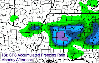
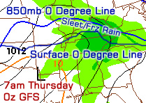
The forecast for Starkville is exponentially more difficult than areas to our north because the Golden Triangle could very well be the battleground between snow, freezing rain, and rain. The 18z GFS model puts a couple inches of snow on the ground here, but the bigger story is the amount of freezing rain that could accumulate. The graphic to the right is the accumulated freezing rain output from the GFS, which shows nearly a half inch of ice accumulation in Starkville by Monday morning. Just a couple counties to our north, snow accumulations could top four inches and ice may not be as much of an issue. Earlier runs of the GFS showed more snow for Starkville with ice becoming more of a problem just to our south. That's just one model though. The NAM, which as I said before does not cover the whole event period yet, seemed to go toward a warmer solution on the 0z run with a bit of snow late Sunday night and plain rain in town on Monday morning (left image). I'd give the NAM a few runs to get things sorted out because lately it seems to have had problems with storms that occur near the very end of it's forecast period. Areas near Tupelo could be the bulls-eye for heavy snow, so I wouldn't be surprised to hear reports of amounts over five inches up there early on Monday.

Bottom line: Significant amounts of snow/sleet and freezing rain are possible in Starkville by Monday morning and we'll need to fine-tune the forecast to figure out which mode of precipitation will be more dominant. Any slight track changes or differences in the strength of the low that will pass to our south will determine what kind of frozen precipitation falls where. The good news is that I think temperatures during the day on Monday will get above freezing, so the mess on the roads during the morning should get better throughout the afternoon.

If you're near Jackson, TN this weekend, be sure to tune in to ABC 7 on Saturday morning at 6am for my latest snow forecast. Should be an interesting few days ahead!

Wednesday, December 15, 2010

12/15 - 5:30pm - Louisville Winter Storm CRUNCH TIME!

The onset of Louisville's first major mixed precipitation winter storm of the season is just hours away and the forecast is still very difficult. The National Weather Service has extended tonight's and tomorrow's Winter Storm Warning to counties in Southern Indiana that were previously only in an advisory. The reason for this is the increase in precipitation totals that both the NAM and GFS have been hinting at today. Those areas in Indiana will see all snow and sleet, with accumulations up to six inches in places.

Here in Louisville the snow should start from the southwest near the 10pm hour and possibly mix with sleet before 1am, with accumulations of around 1-2". Based on the model guidance I've seen, I think we'll switch over to a period of sleet with some freezing rain mixed in after 1am. Freezing rain will become dominant in Louisville just a couple hours after that and last until around 7am with ice accumulations ranging from 0.25" to 0.5". The 18z GFS model (pictured top left) and the NAM both keep Louisville just below freezing at the surface during the entirety of the winter storm, but we're going to have to watch that. The snow we have on the ground will influence the surface temperatures across the area, so the computer models may be running too warm at this point. As I've said before, Downtown Louisville could get a degree or two above freezing during the afternoon and that will help road conditions improve tremendously. The 18z NAM BUFKIT output (second image on left) gives Louisville 1.7" of snow/sleet with a half inch of ice accumulation.

Even with all of this data nothing is set in stone. The storm is forming to our west right now and we're already seeing light snow and sleet falling to our west and southwest. Watching the radar trends and surface observations overnight (called nowcasting) will be crucial to see who gets what kind of precipitation. Louisville is historically the battleground between precipitation types and we'll be in that situation for sure tonight. The HPC (Hydrometeorological Prediction Center) has Louisville and areas south in a Moderate Risk for 0.25" of ice accumulation. Louisville and points north have been put under a Moderate Risk for 4"+ of snow accumulation as well, so we may very well end up with quite a bit of both snow and ice here in the city.


Should this system shift south just a few miles, Louisville would end up with mostly snow and accumulations would pile up to nearly half a foot. I've posted the 12z NAM snow accumulation output on the left just so you can see how incredibly close the heavy snow will be to Louisville, at least according to that model run. A shift northward would severely limit snow accumulations and put us in a mostly ice situation. Either way, Kentuckiana is set to get walloped by winter weather tonight. This will not be as bad as the January 2009 ice storm due to lesser ice accumulations and the potential for slightly above freezing temperatures during the daytime hours in Downtown Louisville and areas south of town as well. We'll see how it all plays out!

Monday, December 13, 2010

12/14 - 12am - Cold is Here and Another Louisville Storm Looms

My apologies for posting so late today. I didn't expect the recovery time from my wisdom teeth removal procedure this morning to last so long, but I think I'm about 95% back to normal now. Cold temperatures are the big story tonight as clouds continue to clear out of the area and cooler air filters in from the northwest. Low temperatures will hover around 8 degrees early tomorrow morning and we're already well into the teens at the eleven o'clock hour here in Louisville. Check out some of the surface observations on the image to the right. Indianapolis and Evansville, IN are coming in at 9 degrees at the moment with temperatures getting even closer to 0 as you make your way toward Peoria, IL. Wind chill values will get a few degrees below zero tonight, especially in the suburbs of Jefferson and surrounding counties.

Our attention turns to yet another storm that should affect the Louisville area as soon as Wednesday evening. If you thought this past storm was a bear to forecast, try figuring this one out! Since temperatures will be hovering near freezing at the surface across the area with upper-air temperatures varying, this is going to be a real mess. The 0z NAM model run keeps Louisville and points northward mostly in the snow, but the 18z GFS had quite a mixed bag of precipitation for us, including freezing rain, sleet, snow, and plain rain. The 0z GFS is just now coming in and it appears that there will be a longer period of snow here in Louisville according to that run, but freezing rain or sleet could take hold on Thursday as warmer temperatures make their way in aloft (still need time for the BUFKIT output to be generated to find out exact precipitation type). If I had to guess right now, I'd say that Louisville and Southern Indiana will start out as snow on Wednesday night before switching over to either sleet or freezing rain sometime early Thursday before gradually changing back to snow as the storm ends. Should temperatures at the surface get just above freezing on Thursday, that period of freezing rain could turn to plain rain at times.

It's a real sticky situation as you can gather from my comments above. Since just a few miles will make a difference during this Wednesday/Thursday event, snow, sleet, and freezing rain amounts will vary wildly across Kentuckiana. I'll have an update tomorrow with more specifics and hopefully the computer models will have a better handle on this storm by then.

Check out some video that I shot of today's snow accumulations in Louisville below:


Be sure to select either 720p or 1080p and play at fullscreen for a high-definition experience.

Sunday, December 12, 2010

12/12 - 9pm - Snow is Making Things Hazardous in Louisville

Hazardous Roads
I just got back from a drive out on the Watterson Expressway, I-64, and the Gene Snyder. All of those interstates had snow on them, but they weren't quite covered. Needless to say, everyone is taking it slow and easy out there tonight. Most side roads and even some major streets have snow cover on them right now around Louisville, so take extra precautions if you're out driving tonight into tomorrow. With temperatures getting below 20 tonight in the city, the salt that Metro road crews have put down will not be as effective and major roadways could be difficult to drive on.

Snow Tonight
Louisville has been getting hit by multiple snow bands throughout the evening and it appears that at least a couple more developing in Indiana right now could hit us later on tonight. Most areas around the city and surrounding counties have seen an inch or two of snow with locally heavier amounts. These snow bands tonight could give us another inch or two in places, so a total snow accumulation of 2-3" in the city looks about right. Many area school systems are already announcing closures tomorrow and I'm inclined to think that schools around Louisville may have delays or closures based on the poor road conditions already present. (EDIT 9:23pm: Jefferson County Public and Catholic Schools have announced they will be closed tomorrow)

Gusty Winds
The winds are really going to pick up tonight on the backside of this storm. Winds just to our west in Paducah, KY and Southern Illinois are topping 25mph and those speeds are certainly headed our way. Winds tonight into tomorrow could get up to 35mph. That kind of wind will put wind chills down to zero and blow this dry, powdery snow around like dust. Visibilities will likely be reduced tonight and tomorrow, so keep an eye out if you're traveling.

Here's some irony for you... I have an appointment to get my wisdom teeth removed tomorrow morning. Not sure if that's still going to happen or not. If the surgeon's office is open tomorrow, I won't be posting on the blog or Facebook/Twitter for about a day or so while I'm recovering. If it's not, I'll have more updates tomorrow!

12/12 - 10am - Louisville Snow Still on Track

It's snowing in Louisville as of this writing and more of the white stuff is on the way. We'll see off and on snow showers today, but they should increase in coverage and intensity as we begin to see snow bands from Illinois cross into the region later this afternoon and evening. I'm still thinking we'll get 1-3" here in Louisville (down a little from yesterday because the cold air did not catch the precipitation fast enough last night) and some areas just to our north could see 4 inches. In contrast, areas around Minneapolis have seen over 20 inches of snow since Friday and the inflatable dome of the Minneapolis Metrodome, home of the Minnesota Vikings, has collapsed.

Winds will be a big issue later on today as they begin to increase and pick up the dry snow on the ground along with what's already falling. Visibilities could fall as this happens, so use caution if you're out and about. Side and back roads could be problematic as well due to snow cover and black ice that could have formed last night. Interstates and major roads look fine based on some of the traffic cameras I've looked at this morning, but use caution.

Saturday, December 11, 2010

12/11 - 10:45am - Louisville Snow Update

More Snow?
It's looking like our snow accumulation totals may be slightly higher here in Louisville than what I was thinking yesterday. The new 12z NAM and 6z GFS computer model runs have shifted the track of the storm slightly southward, which in turn gives us some of the heavier precipitation here in Louisville that Southern Indiana was supposed to receive. Check out the snow accumulation map from the 12z NAM below:


My latest thinking for Louisville is a 2-4" snowfall with possibly 5" just to our north. We'll watch this storm closely... the rain starts this afternoon and changes to snow early tomorrow morning. Watch out for gusty winds tomorrow and Monday!

Friday, March 19, 2010

3/19 - 10:15am - First Day of Spring is Tomorrow!

It's been an enjoyable spring break back home in Louisville and the weather up here is just gorgeous! With fairly strong high pressure in place, I could see it easily getting to 70 degrees or higher today around here.

The next big system to impact the eastern half of the nation is making its way through the Plains as we speak. Winter Storm Watches have been issued from Oklahoma to Missouri and some places could pick up nearly a foot of snow. Below is the highlighted risk for four or more inches of snow tomorrow:

All this talk of snow and the first day of spring is tomorrow? In a period of El Nino (warm sea temperatures just west of South America) like the one we've been experiencing this winter, coupled with a very negative Arctic Oscillation as we've seen, it's quite typical for winter storms to track further south and it seems that El Nino will stick around for the spring as it ever so slowly weakens.

What effect will El Nino have on the spring severe weather season you ask? Based on historical El Nino data, the spring after a fairly strong El Nino winter features more tornadoes and severe weather. This year will be similar to 1995, 1998, 2003, and 2007. We all remember 2007... when a deadly EF5 tornado destroyed Greensburg, Kansas. This is not to say that we're guaranteed to see another EF5 this year, but the potential is higher than last year for sure.

With spring in the air and El Nino sticking around, it's almost time for my annual storm chasing trip in the Great Plains! I'll be out there from May 8th to June 5th and I'm sure it's going to be a great month out there. I'll have blog posts, HD video clips, Twitter/Facebook updates, a live video stream from stormchasertv.com and more as we continue on our quest to find severe weather.

Sunday, February 14, 2010

2/14 - 2:30pm - MSU 7-Day Forecast... More Snow?

Happy Valentine's Day! It looks like we have another shot at some snow overnight tonight and into the early morning hours of tomorrow. All of North Mississippi is under a Winter Weather Advisory tonight and tomorrow as 1 to 2 inches of snow falls across the region after transitioning from a bit of rain. Another hazard with this system is the possibility for ice on the roads tomorrow morning as the wet roads flash freeze in temperatures around the mid 20's. Keep this in mind tomorrow as you're making your morning commute. The rest of the week should be fairly dry with warmer weather by Thursday. Rain is in the forecast for next weekend.


A lengthy winter storm is getting ready to affect Northern Kentucky and Southern Indiana this evening, including the Louisville area. From tonight through Wednesday, the folks back home could pick up over a half a foot of snow. Louisville has already broken their seasonal average snow total, so this storm will only add to an above-average season. Some areas up there could pick up a foot of snow!

Thursday, February 11, 2010

2/11 - 3pm - Southern Snow on the Way!

A major winter storm is on track to affect much of Mississippi this evening and tomorrow. The 12z GFS and NAM models have about 2 inches of snow for Starkville by the time this is all said and done. The 18z NAM that just came out lowered totals quite a bit, but I've noticed at least three times this season when the NAM fluctuated moisture placement just prior to a storm hitting an area. In other words, I'll stick with the 12z suite of models because they were in agreement and made the most sense. Here's a map of the 12z GFS's snow totals:


You'll notice how we're on the north end of the good snow accumulations, so any northward movement of this storm would significantly increase snow totals. We're in the 2-3 inch range on this specific output. Areas south of Jackson could receive up to 9 inches of snow in some spots, with 4-6 inch amounts common near I-20.

This storm is already crossing the border into Mississippi as we speak, so we're getting very close to the time where we throw out the models and start looking at radar trends:


Again, my forecast calls for 1 to 3 inches of snow tonight and tomorrow. Should this change, I'll post here on the blog, on Facebook, and on Twitter as well.

Wednesday, February 10, 2010

2/10 - 3:10pm - New HPC Outlook

The HPC just issued a new snow outlook:

We're just north of the slight risk for 4" of snow in Starkville according to this outlook, but areas near Jackson are in the moderate to high risk areas, meaning they could see heavy snow down that way. Still quite a few details to be hammered out with this storm, so keep up with the latest forecast!

2/10 - 2:15pm - Update on Friday's Snow in Starkville

The computer models today have started trending a little further north with the track of the storm on Friday. This essentially means that we've gone from virtually no snow for Friday to a dusting now. If the models keep pulling the Gulf low with this storm further north, we would certainly see an accumulating snow on Friday, somewhere in the neighborhood of 1-4". This is a wait-and-see kind of game at the moment, but I think a more accurate storm track will be hammered out by tomorrow. An interesting development today has been the HPC's latest 4" snow risk product:


The slight risk for 4" of snow goes all the way up to Tupelo, MS, which you can see above depicted by the blue outline. This doesn't mean we'll see 4" of snow in Starkville, but it does mean that the HPC (Hydrometeorological Prediction Center) is monitoring this northward shift. There are still many model solutions out there for this storm's track, but it does appear that the average track has shifted northward just a bit. We'll see how the next few model runs pan out.

I hope everyone back home in Louisville is enjoying the snow! The NWS's official snowfall total was 6.5", so it was a pretty big storm by Kentucky standards. Jefferson County Public Schools could be making a decision about school tomorrow by 5pm according to the Courier-Journal. With two days of school cancellations in Louisville already this week, a third day would certainly give the all the kids another day to play in the snow!

Thursday, January 28, 2010

1/28 - 9:30pm - Big Ohio/Tennessee Valley Snowstorm

If you live anywhere in between Louisville, KY and Chattanooga, TN, you're in for some snow tomorrow! A very potent storm is on the way and will assuredly cause headaches throughout the region this weekend. Winter Storm Warnings (pink counties on image), Winter Storm Watches and Winter Weather Advisories (blue counties) have been issued for much of the area already ahead of this storm. Here are some sample forecast snow totals for select cities:

Louisville, KY - 4-6"
Bowling Green, KY - 6-8"
Lexington, KY - 5-7"

Nashville, TN - 4-8" with ice
Memphis, TN - 1-3" with ice
Knoxville, TN - 3-6"

Louisville is on the very north end of this system, meaning that a storm track change of only 20 miles could throw off totals quite a bit. In the same fashion, Memphis, Nashville, and Knoxville are on the southern edge of this system and the same rule applies. Anywhere in between these cities is in pretty good shape for seeing snow regardless of micro track changes.