Showing posts with label christmas. Show all posts

Friday, December 21, 2012

12/21 - 2pm - I'm Dreaming of a White (Day After) Christmas

How about that snow last night around Kentuckiana? Most places saw a dusting but areas in Southern Indiana near Orange County picked up about 3 inches since a snow band set up there for a few hours during the overnight. Here at my house in Southeast Louisville we picked up a dusting of snow that blew around a bit in the wind. Temperatures today aren't going to make it out of the mid 30's in Louisville today thanks to the cold air behind the front that passed through yesterday. Seems appropriate given that it's the first day of winter!

Temperatures will moderate for the weekend with southerly flow returning but an area of low pressure moving through will bring rain and even warmer temperatures for Christmas Eve. Booooo! Luckily Christmas Day isn't looking like a washout with just a few clouds and highs in the lower 40's. That's a different story further South in Mississippi, Alabama, and Georgia where rain will be setting up.

Now... onto the fun part. Over the past couple of days the forecast models have been jumping onto the idea of an area of low pressure moving from the Gulf states to the western side of the Appalachian Mountains the day after Christmas. This is concerning because this track favors a snow event for Kentuckiana and even some of West Tennessee. You need to be on the north and west side of these low pressure systems if you want to see some snow since that's where the cold air is confined to. The past few systems we've been on the south and east sides of the lows moving though so that has meant thunderstorms and warm weather lately.

The latest 3 runs of the GFS for this particular post-Christmas storm have been fairly consistent with the low track, which is good! The problem has been that there's been trouble determining how much cold air there will be to work with and how strong/large the low moving through will be. These issues have affected how much snow the Louisville area gets. The graphic on the left is a comparison of the last 3 runs of the GFS for December 26th. For entertainment purposes only, the 0z run had just shy of 8" of snow for Louisville, the 6z had about 3", and the 12z had around 2.5". It is still way, way too far out for specific totals and to worry about the cold air issues yet since things will change likely on the models between now and then. I will say though that the 6 and 12z runs seemed to have difficulty keeping the low as a single, compact system once it matured and instead wanted to go with an elongated large low that tries to interact with another low that develops east of the Appalachians. I've seen this kind of thing happen on the GFS earlier this year with the Nor'easters that we had. Eventually, based on what happened with these Nor'easters, these elongated lows should give way to more concentrated, compact lows on the GFS as we get closer to the actual event. This should help to clear up some of the murkiness with the cold air issues too.

The Euro has been fairly consistent with the track of the low as the GFS has been, but has also experienced a few issues of its own like the GFS. Yesterday's 12z run of the Euro had a blockbuster snow event in the Louisville area while the 0z last night backed off on that prospect thanks to, you guessed it, a more elongated low and trouble with cold air. I can't post the precipitation output from the Euro model since it's behind a paywall and copyrighted, but I can at least show you what the 0z run did with the low after it moved through. Lots and lots of cold air will be behind this system if you couldn't tell by the deep blues and purples on the map!

UPDATE 2:20pm - Today's 12z Euro model run is in and it has a blockbuster storm track for snow for us here in Kentuckiana and West Tennessee. That is quite a strong low in East Tennessee on the left-hand map compared to previous runs. Sheesh.

The CMC and the JMA, which are the Canadian and Japanese models, aren't worth showing here right now. The CMC has the storm running off the east coast and the JMA has a nice low track for some snow in Louisville. It's worth noting that this system might disappear all together on the models or make a radical change. It's still too far out for much certainty.

Also, West Tennessee may see snow from this storm should it take the track that we're seeing. It wouldn't be much snow but certainly more than an inch or so isn't out of the realm of possibility, especially in Northwest Tennessee. Once we get closer to time this will become a bit more clear.

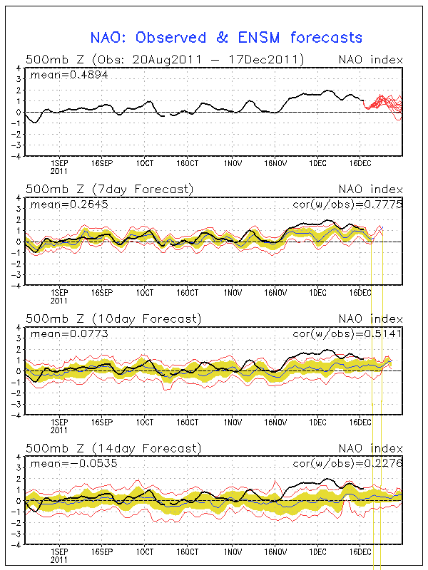
The NAO, which is the North Atlantic Oscillation, frankly isn't agreeing that there will be support for this storm. A negative NAO means blocking near Greenland allows for cold air to flow into the Eastern US and stay locked in place. The current forecast is for a positive NAO during this time, but it has been flipping between negative and positive over the past couple of days. This storm doesn't have to have a negative NAO to happen, but it would help to have it for cold air support and for a storm track that rolls up to the northeast. This will, like the aforementioned models, sort itself out over the next few days.


Finally, NWS Louisville has been on board with this storm since yesterday. They're being cautious like they should be but mentioning at length the potential for this at 5 days out is something that they don't do very often. Here's their latest statement:

A much more significant weather system will arrive on the 26th. Both the 00z GFS/ECM and ensembles track a strong low pressure system just to the west of the Appalachian spine which may set us up for our first significant snow. If the low pressure system takes its current forecast track, precipitation would enter the area Wed morning with the bulk of precip occurring Wed during the day and then exiting late Wed night or Thurs morning.

Although there is still much uncertainty in the track of this weather system 6 days out, the possibility is there for significant snow based on the low track and anticipated thermal profiles. BUFKIT GFS showed 8 inches at SDF with a little more than 0.5 inch of qpf. The soundings denote a classic heavy snow sounding with subzero and deep isothermal layer super saturated. The synoptic features of interest are a 110 kt jet max entering a the base of a deepening trough.

For now will have 60% pops on the 26th with rain in the morning and then snow in the afternoon and Wed night. Bing Crosby`s I`m dreaming of a White Christmas may happen, just 24 hours later.

Stay tuned for upcoming forecast updates as this weather system may put a kink in holiday travel plans.


This will be a fun system to watch over the weekend. Hopefully there's some snow in our future!


Tuesday, December 11, 2012

12/11 - 10:30pm - Be Careful When Wishing for Snow... You Might Get it!

With all the warmth much of the eastern portion of the nation has been experiencing lately some folks are beginning to get antsy over whether we'll be able to fall into a more winter-like pattern in time for the holidays. The cold front that rolled through earlier this week has helped to assuage some of those fears as it brought much cooler temperatures and even some light snow/sleet to parts of Kentucky and Indiana.

So... What's next? First up is a system that will move through the region this weekend as a warm one. A low will travel from the Plains to Lake Michigan and keep the eastern half of the nation warm as it spreads rain from the Great Lakes to the South. This makes sense because the North Atlantic Oscillation (NAO) will be going neutral during this time, which generally means that cold air won't be able to spill down into the Eastern US from Canada. The Arctic Oscillation will be negative to support cold air coming out of the north, but that doesn't matter too much for us when the NAO isn't negative as well.

The system behind this weekend's is the one that is drawing some concern. A low will be moving across the South during the day on Tuesday and potentially spread some snow to areas that are north of it. At this point anywhere from West Tennessee to the Louisville area is in a potential corridor for snow. This all depends on the exact track of the low and how much cold air it will be able to bring down from the north. This scenario is supported by the NAO and AO both going negative during this time. The GFS model takes the storm along the southern border of Tennessee right to the Carolinas. The ECMWF (European) model starts out with the low a little further south along the Mississippi River but has it exit off the coast in about the same location as the GFS. The low would then become a storm that would ride up to the Northeast just off the coast. With the previous system pulling up toward the Chicago area, this low will likely stay suppressed to the south. So... the broad, general nature of this low's track isn't in too much question. My preliminary (read: subject to change!) thinking is that this will be a rain to light snow situation for portions of Tennessee and Kentucky since cold air would plunge in as the system is exiting to the east. Accumulations would be very light to none.

But here's an issue. The snow cover over the Northern Plains and Upper Midwest has expanded tremendously over the past week as a storm pummeled those areas with quite a bit of snow. We're now at 31.4% snow cover over the United States. Air moving from the north over that snow won't warm as quickly as it would over bare land and the computer models generally have a difficult time resolving that. With this snow cover, the air in place over us and the air coming down from the north may be a little cooler than the computer models think it will be at the moment. That could mean more snow from this system. We're still a week away from this event so while details are sketchy, it's now obvious that this is a system to watch. This likely won't be the only storm we'll have to contend with between now and the new year since a pattern is setting up that will allow cold air to sit close by to the Ohio and Tennessee Valleys while lows track through and just to the south of the region. There's hope for a white Christmas in the region but it will depend on whether we can get enough cold air and a storm to move through just before the 25th. It'll be fun to watch!

Saturday, December 17, 2011

12/17 - 11:50pm - A Not So White Christmas

Positive NAO - http://www.ldeo.columbia.edu/NAO
Christmas is just a week away and snow chances for many in the eastern half of the nation look pretty bleak. The next major system to pull through on Tuesday and Wednesday will produce snow in the Plains, but to the east it's expected to be all rain. A second low moving through the Deep South on Friday will bring more rain, but most of that will stay south of Kentucky and the heaviest south of Tennessee. After that point it looks pretty dry right through Christmas. Why so rainy and relatively warm lately? It has to do with the North Atlantic Oscillation, or NAO for short. When the NAO is negative, storms tend to ride up the East Coast or just west of the Appalachian Mountains. This is a recipe for snow for many across the East since these storms have cold air streaming in just to the north of their track. When the NAO is positive, storms begin deflecting northward to Canada before they reach the Mississippi River. This means that the cold air and snow with these storms stays out in the Plains. The NAO is in this positive phase right now and isn't forecast to go neutral or even negative until around the new year (see forecast and history chart to the right). Until we can get the NAO negative, I wouldn't bet on a winter storm for Kentucky, Tennessee, or much of anywhere else in the East.

23% of the United States is covered by snow at the moment, which is quite a bit lower than the 47.3% covered by snow at this time last year. Aside from Lake Effect snowcover in Pennsylvania and New York and snowcover in northern Maine, the East is snow-less.

A big winter storm is forecast to hit New Mexico, the Texas/Oklahoma Panhandles, and Kansas on Monday and Tuesday as an area of low pressure cuts northeastward (because of the positive NAO as explained above) through the Plains. A Blizzard Warning (green color on right image) has been issued for Northeast New Mexico while the other areas are under a Winter Storm Watch. Areas in the core of the snowfall north of Amarillo, TX up through Dodge City, KS could get well over a foot of snow.

Monday, November 28, 2011

11/28 - 8pm - Starkville Christmas Parade Weather Report

This evening WOBV-TV 5 in Starkville, MS aired a weather forecast I put together for this year's Starkville Christmas Parade TV broadcast. Check out this video from tonight's program:


Scroll down to see my thoughts about the ongoing winter storm impacting much of the Mid-South right now.

11/28 - 2:45pm - An Early Shot of Winter Weather

A complicated upper-level low is making for some difficult forecasting over the next 24 hours as it brings the first real chance of snow to the South this season. This upper-level low is basically a big bubble of cold air aloft that has been orphaned from a bigger system that has since moved away from the region. Since we still have showers in the area, this cold air will help to turn those into snow by late tonight in areas near Starkville and northward. Since temperatures at the surface here in Starkville won't make it above 34 or so, any brief period of snow we see will not stick to the ground. I do think there could be a complete changeover to snow here in Starkville tomorrow morning around 8 or 9am, but this is highly dependent upon how well the computer models handle this system. Further north near Tupelo, Memphis, and Jackson, TN there will be enough cold air to get the snow on the ground when it falls, but the vast amount of warm rain we've had lately has kept the ground warm and moist, so snow accumulations won't stick around for long. Travel hazards won't be a huge deal since the roads are still warm, but it's a good idea to keep a look out for slick spots where temperatures dip below freezing tonight. Click on the SREF model snow output to the right... I think it has the most reasonable estimate on who will get accumulating snow tonight.

A Winter Storm Watch has been issued for areas from Tupelo to McNairy County, TN until 6am tomorrow since heavier snow could result in accumulations of 3 inches or more. The Winter Weather Advisory around the periphery of the Watch is for wet snow accumulations that could total around 1 to 3 inches. The snow should end by late morning tomorrow as it converts back to rain showers and then the precipitation will clear the area completely by around noon or so.

Check out my video below for a complete look at this week's forecast in Starkville and more details about the snow that's headed our way:


This evening at 6pm is the annual Starkville Christmas Parade. I'll be doing a short weather segment for the parade broadcast on WOBV 5 in Starkville. This event will also be streamed live on the web, so be sure to check out http://parade.wobv5.com/ tonight at 6pm CST to see my forecast and enjoy the parade!

Monday, December 6, 2010

12/6 - 8pm - Video from the Starkville Christmas Parade

I was able to get my hands on some video of WOBV 5's coverage of the Starkville, MS Christmas Parade that I participated in. I've edited an eleven minute highlight reel of my street reporting that you can view below. You may recognize a few familiar faces in there like meteorologist Jennifer Watson from WTVA-TV in Tupelo, MS and Jason Dunning from WCBI-TV in Columbus, MS. Both graduated from Mississippi State University's award-winning meteorology program and were real troopers for letting me stick a camera in their faces during the parade!

Sunday, December 5, 2010

12/5 - 2pm - WBBJ and Starkville Christmas Parade All in One Day!

The forecast for Jackson was fairly tame yesterday as a cold front was poised to swing through the area and bring cooler temperatures into the region. Highs could get into the 30's and lows into the teens this week, so bundle up! Check out my video from ABC 7 below:


As if waking up and going on-air early in the morning in Jackson wasn't enough yesterday, I drove back to Starkville to participate in WOBV 5's TV production of the Starkville Christmas Parade. Like last year, I interviewed participants on the floats and attendees on the street for the station and had a great time doing it! Since this year's broadcast was not live, I'll have to get a recording of the program and post it here later on in the near future.

It's final exam week here at Mississippi State, so that means I'll be heading back to Louisville for the long winter break coming up on Thursday. I'm watching a potential snowstorm that could happen up in Louisville next week like a hawk and I'll post some updates on that once I knock out these final exams.

Saturday, December 26, 2009

12/26 - 2:15pm - Still Watching for New Year's Snow

I hope that everyone had a wonderful Christmas yesterday and that the lack of snow around here didn't get anyone down in the dumps.

As we shift our focus to the new year, we may also have to shift our focus to a chance of snow in Louisville. Over the past week, the long-range GFS computer model has been showing a storm tracking through the Gulf states. While the moisture and precipitation with this storm has been suppressed to the south on most model runs, I'm starting to see the (this) season-typical northward trend in the track of this storm.

The Euro model has this storm tracking from the Gulf Coast to Virginia, which would be a fairly decent track for us to have snow in Kentuckiana if enough moisture accompanies the storm. My worry is that there may not be enough cold air in place to counter the warm air being brought north by the storm, and this may negatively affect our snow chances. It's still too early to tell if this will indeed be a problem, but at least the storm track is good at this point.

Basically, the graphic from the last post with the potential storm tracks of this system still applies. There are a lot of factors like phasing, the polar vortex, and model-to-model differences that need time to get hammered out. I'd say this is our best chance for snow so far this season, and I think this is certainly a system that bears watching.

Wednesday, December 23, 2009

12/23 - 3pm - Plains Blizzard, Snow in Louisville?

The big storm getting ready to spread rain around Louisville on Christmas Eve will slam into the Plains as a major snowstorm with blizzard conditions possible. Ice will be a big issue out there as well, especially in places nearer to the area of low pressure like Omaha and Lincoln, Nebraska. Some places could end up with more than 20" of snow, especially in areas north of Nebraska. Winter Storm warnings and watches have been issued as the storm cranks up today.

Rain should begin in Louisville early tomorrow and taper off as we go through Christmas Day. I know it's a bummer to have rain around Christmas like this, but at least we won't have any travel problems around the region.

The next chance of snow could come just before the new year. A system on the long-range GFS computer model is still showing some potential for us, even though we are not forecast to get any snow as of now. The storm track at the moment is very far south of us, but the GFS model has been notorious for shifting suppressed storms northward a few days before the actual event. This happened with the current storm. As you may remember, the current Plains storm was supposed to track south of us and give us snow, but the northward trend took over and sent the storm west of the Mississippi River. My only concern with the potential New Year's storm is that we may have a surge of warm air from the south, which could limit our snow chances. It's really far out to be making any sort of detailed prediction at this point, but I think this storm will make a snowy impact on parts of the region.

Saturday, December 19, 2009

12/19 - 12:15pm - Update on Snow Chances

Snow did not fall in the Louisville area this morning as forecast because of warmer than expected temperatures both near the surface and just a couple thousand feet aloft. The short-range RUC model runs have been indicating a slow cool down of temperatures over the next few hours, so rain should change to snow later this afternoon. We may pick up a half inch on the grass tonight with any lingering snow showers.

The Christmas Eve snowstorm is having a very difficult time on the computer models right now. The most current 12z GFS run has mostly rain for us because the low cuts up to Chicago, but the previous few runs had been indicating a track just south of Louisville that would give us rain to snow or all snow. With solutions varying wildly from run to run, I don't think we'll have a track narrowed down until the start of next week. I will say that the pattern favors the southern track with snow for us because of high pressure in Canada suppressing any northward movement of the storm. The storm should be following this rule on the models, but unfortunately this is not happening with many of them. At least we still have a chance for snow! Here are some potential storm tracks that the models have been hinting at for the past couple days:

Thursday, December 17, 2009

12/17 - 12pm - Louisville Snow Chances Increasing!

This weekend's snow has really cranked up on the computer models over the past 24 hours. Moisture on both the NAM and GFS has increased considerably, meaning we could be left with over two inches of snow by Sunday night. The combination of the coastal winter storm giving us some outlying snow and the round of clipper systems from Canada should be beneficial for snow totals, but I'm just a little worried about surface temperatures. I think we'll top out at 33 or 34 on Saturday, which should be when the bulk of the snow is falling. This will melt things a little bit, but I think things will cool down quickly at night and snow will still be falling. A little burst of snow on Sunday should top off our accumulations of 2 or more inches.

The Christmas Eve storm is still up in the air at this point, but I think our chances are getting better for an accumulating snow. The 6z run of the GFS had the storm going to our south (that's good for snow here) and put down over 5 inches of snow. The 12z has a strange solution with mostly snow here, but the low pressure associated with the storm takes an odd path northward to Tennessee then cuts east. We'll see how this track goes, but I think the fact that the storm is still on the computer models and that there is a potential track that favors snow for us is a good thing.

Tuesday, December 15, 2009

12/15 - 11:30am - Clipper Snow, Christmas?

A clipper system (low pressure that dives south from Canada) is forecast to come through the region this weekend, spreading light snow around Louisville. It looks like there will be some accumulations, just enough to whiten the ground by the latest estimates. I'm not terribly sure of the exact amount of snow we'll receive because this system has been bouncing around on the computer models. The main idea is that snow showers will start on Friday night and continue through Saturday.

You may have seen my various hints on Twitter and Facebook about some sort of snowstorm developing next week just in time for Christmas. The GFS long-range model had been advertising a potentially potent storm on December 24th for us, but that has since disappeared in the last few runs of the model (which could be due to the fact that the GFS model had some technical upgrades implemented today). Fear not! That storm has been replaced by several rounds of light snow between the 22nd and the 25th, meaning we still have a chance for a white Christmas if this happens. We're still 10 days away, so the forecast models will be very erratic and our big storm may even come back. On the flip side, there's a good chance that the snow could disappear completely and we'd be left with a cold, dry Christmas. Either way it'll most likely be cold enough to snow. Don't get too excited yet because this is a tricky forecast, but keep in mind that we could be dealing with some snow on or around Christmas.

Saturday, December 12, 2009

12/12 - 11:45pm - Looking for Snow

I know many of us here in Kentuckiana are waiting for the first big snow of the season. While we generally don't see much snow around Louisville in December, the pattern right now in my opinion is very ripe for an early season snowfall. The long range computer models (GFS & Euro) heat things up this weekend and early next week, but temperatures quickly turn downhill again by the middle of next week. We may even see a small bit of snow next weekend with a possible clipper system. The southern storm track, the one that brings most of our snowfall, has been and will continue to be very active throughout the arrival of this new batch of arctic air next week. Receiving snow in Louisville is all about timing, which means we have to have an abundance of cold air in place as a low pressure system tracks to our south and east, preferably along the mountains of Eastern Kentucky. Having one of these components out of place would mean rain or ice for us here in Louisville.

Many have asked: Does it look like we'll have a white Christmas? The answer is maybe. The possibility for light snow between now and the 25th looks pretty good right now, but getting a big storm in here will be tough. The GFS computer model has been hinting at some sort of snow event around Christmas for a couple days now, but accuracy that far out is very low. I'd say our chances for a white Christmas are probably the best since 2004, when we had a crippling snow/sleet system dump over a foot of snow in Louisville and Southern Indiana on the 22nd and 23rd of December. Just keep in mind that the pattern is ripe for snow, but that the specifics are blurry at this point.

If you're desperate to see some snow, head across the Ohio River to Paoli Peaks in Southern Indiana. They've been able to generate enough machine-made snow to open for skiing this weekend and they should be able to keep that snow on the ground through the warm spell we'll see early next week. Guess it's time to hit the slopes!

Wednesday, December 2, 2009

12/2 - 2pm - Reporting from the Starkville Christmas Parade

Here's the big announcement you've been waiting for!

I'm going to be an on-the-street reporter for the Starkville Christmas Parade this weekend. My responsibilities will include interviewing parade spectators and participants live on camera, as well as doing some promotional and weather spots. The parade will be broadcast live on cable channel 5 WOBV here in Starkville starting at 5pm on Saturday. The broadcast will be shown repeatedly throughout the month of December as well. I'll be sure to record it and post it here on the blog for everyone to see.

You may be wondering how I came to get in this position. Through some wonderful connections I have at Mississippi State's IT department, I was asked to fill-in for the person who normally has this position. With this being my first long-form broadcasting gig, I'm really excited and I cannot wait to get out there and meet everyone!

Again, if you're in Starkville, this will air at 5pm Saturday on channel 5 WOBV. See you then!

Wednesday, December 24, 2008

12/24 - 11am - A Wet Christmas Eve

Merry Christmas Eve everyone! Heavier rain is on the way as the tail end of this system approaches the area today. A Wind ADVISORY is in effect until 4pm this afternoon as gusts up to 40mph are expected as this storm passes. As promised, Christmas Day will be dry with a high in the mid 40s.

Beyond Christmas, we could see some troubling weather. The GFS is bringing a line of severe thunderstorms (yes, you read that correctly) through the area ahead of a pretty powerful cold front on Saturday. With good shear, high dewpoints, and a potent source of lift, this could be a pretty widespread severe event. The SPC has outlined an area that will be affected by this event, which does not include us right now. We might be in there in the next outlook based upon what I'm seeing in the models, but let's see what happens.


In the long range, the return of the fabled eastern trough is imminent. We've been warm due to the southeast ridge that has dominated over the past couple weeks. If the models are correct, the return of cold air and chances for snow should arrive mid-way through the first week of January.

Tuesday, December 23, 2008

12/23 - 11:30am - Freezing Rain ADVISORY

If you've been outside this morning, some of you may have noticed a light coating of sleet on your front porch or driveway. More sleet and freezing rain is on the way for this afternoon as moisture comes into the area from the west with warmer temperatures aloft. Accumulations will be light, so the National Weather Service has issued a Freezing Rain ADVISORY. Since we're already holding at around 30 degrees in Louisville, I expect any precipitation to change to plain rain later this afternoon. This should be all said and done before nightfall with few travel problems, if any. Temperatures will be heading higher during the overnight hours, so another changeover to frozen precipitation is not expected tonight.

I hate to say it, but we have nearly 2 inches of rain on the way according to the HPC. This will fall from tonight until tomorrow night, leaving Christmas Day clear and sunny. This scenario verifies on both the GFS and NAM, so I'm confident we won't see any surprise rain on Christmas morning.

Monday, December 22, 2008

12/22 - 8pm - A Little Bit of Ice on the Way

Its 11 degrees at my house now, with 19 at the airport. Other suburban stations are reporting temperatures of 12 to 14 degrees right now. That right there shows the heat island effect in action, with the concrete and buildings near the airport and downtown driving the temperature up a few degrees.

As we warm up tomorrow, we could see some freezing rain in the early afternoon. Latest indications show that this shouldn't be a problem because we will get above freezing by late afternoon, turning any frozen precipitation to rain and melting any light accumulations of ice. Rain will continue for Wednesday and should taper off late that night. Expect sunny skies and a high in the mid 40s for Christmas Day. While we can't get a white Christmas, at least it will stop raining!

Friday, December 19, 2008

12/19 - 5pm - Windy and Wild

We reached a high of 69 this afternoon, which is most certainly rare for this time of year. A Wind Advisory is currently in effect and winds gusted up to 40mph earlier this afternoon. We should see winds die down as and temperatures drop throughout the evening (we're already down over 10 degrees from where we were around 1pm).

Temperatures will top out near 50 tomorrow with a little bit of rain in the afternoon and a bit of light snow in the evening. As we dive below freezing for a high on Sunday, a few flurries are possible. We'll be below freezing for Monday as well, but we'll rise to the mid 30's for Tuesday.

The GFS is really pumping in some warm air for Christmas Eve and it looks like we'll see heavy rain. Oh no! The rain should be out of here by Christmas Day. This is far from being set in stone, but I haven't seen anything to convince me that this area of low pressure will go south and give us a white Christmas. I'll keep watching, but I'm not optimistic for snow at this point.

Meanwhile, a nasty winter storm is causing havoc in the Midwest and Northeast. Cities like Chicago and New York are having problems with cancelled flights and heavy snow... click here to read more.

Thursday, December 18, 2008

12/18 - 6pm - It's 6 Days Away, But I Can Smell Rain Already

First off, rain is on the radar and on the way. We'll see at least a few showers tonight and possibly some heavier rain early tomorrow morning and into the afternoon hours as well. Lighter rain returns for Saturday afternoon, and could end as some snow showers on the backside of the system on Sunday morning. Temperatures near 50 for Friday and Saturday should cease as the cold front comes through, with a high near 30 for Sunday. Frigid temperatures will continue for next week.

On to the elephant in the room, the possibility of snow for Christmas. The latest model runs of the GFS have been utterly disappointing with mostly rain, if not all rain, for the whole Christmas Eve system. This trend started on the 18z run last night, as I alluded to in the last post, and is rearing its ugly head in all runs today. The Louisville NWS office is unsure of what to call for in their forecast discussion in terms of precipitation type, but they do keep temperatures cold and the precipitation type as snow on their 7-day forecast. I admire how they're sticking to their guns on this one, so maybe we still have some hope. We're 6 days out and model accuracy at this point downright stinks for complex low systems like this. I'd give this some time before I lose all hope, but just know that things are on a downswing at the moment for a white Christmas.

Wednesday, December 17, 2008

12/17 - 8pm - White Christmas?

We barely got above freezing today, and that happened in the wee hours of this morning! Things stayed quite cold with dreary cloud cover. Expect some fog tonight and into tomorrow morning. We should top 40 tomorrow and soar to near 60 on Friday!

By Friday, we'll see a storm system come through with a considerable amount of rain. That should exit the area by Friday night. As yet another low pressure system makes its way through north of the area, we'll see more rain for Saturday evening and into Sunday.

That system over the weekend will usher in some very cold air... you know where this is going... and could make way for a snowstorm on Christmas Eve. You may say, "but Ryan you messed up yesterday's snow prediction, how the heck can you expect to forecast snow this far out!?" The answer to that lies in the size of the storm. Yesterday's area of snow was only 20-30 miles wide, and went south of us at the very last minute. This storm will be a monster in comparison, so more areas are likely to get snow, meaning a decrease in forecasting error as well.

The 18z GFS gave us a rain event, but the 12z and the 6z all agreed that this would be a snow-centered storm. The NWS is already calling for snow in their 7-day forecast, so that gives me a little more confidence. The 18z worried me about this being a "Great Lakes Cutter," meaning a storm where the low cuts north to the Great Lakes and keeps snow west of the area. But if I recall correctly, the 18z runs have not been reliable this season, especially for yesterday's storm. So I think we can throw out that model run unless that low track comes up on the oz tonight.

In any case, we haven't had a Christmas with decent snow on the ground since 2004. If we can stay the course with a low pressure track south of us, I think we're in good shape. At this point, I'll call this a chance for snow and nothing else. I don't want to call this one too early... a busted Christmas snowstorm forecast would cause an angry mob (the city of Louisville) to come after me!