|
| Positive NAO - http://www.ldeo.columbia.edu/NAO |
Christmas is just a week away and snow chances for many in the eastern half of the nation look pretty bleak. The next major system to pull through on Tuesday and Wednesday will produce snow in the Plains, but to the east it's expected to be all rain. A second low moving through the Deep South on Friday will bring more rain, but most of that will stay south of Kentucky and the heaviest south of Tennessee. After that point it looks pretty dry right through Christmas. Why so rainy and relatively warm lately? It has to do with the
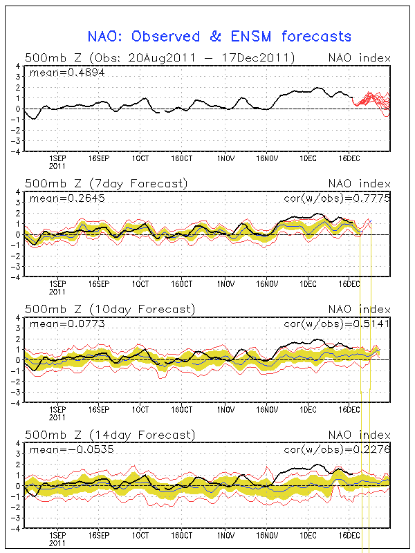
North Atlantic Oscillation, or NAO for short. When the NAO is negative, storms tend to ride up the East Coast or just west of the Appalachian Mountains. This is a recipe for snow for many across the East since these storms have cold air streaming in just to the north of their track.

When the NAO is positive, storms begin deflecting northward to Canada before they reach the Mississippi River. This means that the cold air and snow with these storms stays out in the Plains. The NAO is in this positive phase right now and isn't forecast to go neutral or even negative until around the new year (see forecast and history chart to the right). Until we can get the NAO negative, I wouldn't bet on a winter storm for Kentucky, Tennessee, or much of anywhere else in the East.
23% of the United States is covered by snow at the moment, which is quite a bit lower than the 47.3% covered by snow at this time last year. Aside from Lake Effect snowcover in Pennsylvania and New York and snowcover in northern Maine, the East is snow-less.
A big winter storm is forecast to hit New Mexico, the Texas/Oklahoma Panhandles, and Kansas on Monday and Tuesday as an area of low pressure cuts northeastward (because of the positive NAO as explained above) through the Plains. A Blizzard Warning (green color on right image) has been issued for Northeast New Mexico while the other areas are under a Winter Storm Watch. Areas in the core of the snowfall north of Amarillo, TX up through Dodge City, KS could get well over a foot of snow.

 With all the warmth much of the eastern portion of the nation has been experiencing lately some folks are beginning to get antsy over whether we'll be able to fall into a more winter-like pattern in time for the holidays. The cold front that rolled through earlier this week has helped to assuage some of those fears as it brought much cooler temperatures and even some light snow/sleet to parts of Kentucky and Indiana.
 So... What's next?
First up is a system that will move through the region this weekend as a warm one. A low will travel from the Plains to Lake Michigan and keep the eastern half of the nation warm as it spreads rain from the Great Lakes to the South. This makes sense because the North Atlantic Oscillation (NAO) will be going neutral during this time, which generally means that cold air won't be able to spill down into the Eastern US from Canada. The Arctic Oscillation will be negative to support cold air coming out of the north, but that doesn't matter too much for us when the NAO isn't negative as well.
So... What's next?
First up is a system that will move through the region this weekend as a warm one. A low will travel from the Plains to Lake Michigan and keep the eastern half of the nation warm as it spreads rain from the Great Lakes to the South. This makes sense because the North Atlantic Oscillation (NAO) will be going neutral during this time, which generally means that cold air won't be able to spill down into the Eastern US from Canada. The Arctic Oscillation will be negative to support cold air coming out of the north, but that doesn't matter too much for us when the NAO isn't negative as well.
 The system behind this weekend's is the one that is drawing some concern. A low will be moving across the South during the day on Tuesday and potentially spread some snow to areas that are north of it. At this point anywhere from West Tennessee to the Louisville area is in a potential corridor for snow. This all depends on the exact track of the low and how much cold air it will be able to bring down from the north. This scenario is supported by the NAO and AO both going negative during this time. The GFS model takes the storm along the southern border of Tennessee right to the Carolinas. The ECMWF (European) model starts out with the low a little further south along the Mississippi River but has it exit off the coast in about the same location as the GFS. The low would then become a storm that would ride up to the Northeast just off the coast. With the previous system pulling up toward the Chicago area, this low will likely stay suppressed to the south. So... the broad, general nature of this low's track isn't in too much question. My preliminary (read: subject to change!) thinking is that this will be a rain to light snow situation for portions of Tennessee and Kentucky since cold air would plunge in as the system is exiting to the east. Accumulations would be very light to none.