

Showing posts with label Mississippi. Show all posts
Showing posts with label Mississippi. Show all posts
Monday, April 22, 2013
4/22 - 6:30pm - Great Start to the Week, Rain Ahead in Starkville
Wednesday, April 17, 2013
4/17 - 6:35pm - Severe Weather Tomorrow in Mississippi

Thursday, April 11, 2013
4/11 - 7pm - Rough Day of Severe Weather, Sunshine to Come

Tuesday, April 2, 2013
4/2 - 10:45pm - After Some Rain, a Warm Weekend in Mississippi
 A stationary boundary stretched across Mississippi is giving folks to the south quite a bit of warm weather this evening but we're cooling down here in Starkville as we remain on the north side of it. An associated area of low pressure currently in Texas will move through the region later this week, triggering showers on Wednesday and Thursday. While temperatures will take a small tumble on those days we'll warm up vigorously into the 70's by the weekend. Check out your CampusConnect Forecast below for all the details!
Monday, March 25, 2013
3/25 - 11:35pm - Weather Says January, Calendar Says March

Wednesday, March 6, 2013
3/5 - 11:55pm - Warmer Weather Ahead in East Mississippi!

Thursday, February 28, 2013
2/28 - 10pm - Snow Showers Possible in MS This Weekend

Tuesday, February 19, 2013
2/19 - 11:30pm - Strong Storms in Mississippi Later This Week
 After a nice warm day in Starkville we're gearing up for a cooler, cloudier day tomorrow before storms set in on Thursday. The Storm Prediction Center has issued a Slight Risk of severe weather on Thursday for areas southwest of Starkville. We're right on the fringe of it. Since moisture return and instability look rather limited, the potential in the Golden Triangle for severe weather will be fairly marginal and centered around gusty winds, heavy rain, and frequent lightning. It's certainly something to watch though. Rain should clear out for the weekend and leave us with a warm and partly cloudy stretch of weather. Check out the video below for all the details!
Thursday, February 14, 2013
2/14 - 11:55pm - A Curveball Forecast for MSU Baseball

Tuesday, February 5, 2013
2/5 - 10:30pm - Dense Fog Tonight

Thursday, January 31, 2013
1/31 - 11:15pm - Snowy to Our North, but Clear Here!

Tuesday, January 29, 2013
1/29 - 5:45pm - Serious Severe Weather Concerns Tonight
Latest Severe Weather Updates
 A severe weather setup that we see normally in the springtime is about to unfold on this late January night across a large expanse of the Southeast. While not "unprecedented" or "once-in-a-lifetime", this outbreak is going to impact quite a few people and it's important that everyone have what they need to be prepared and safe. This post is mainly for folks in North Mississippi and West Tennessee, but you can figure out pretty well how you'll be affected if you're not in these areas by some of the maps and information below. Everyone needs to be aware of what's going on because this will be happening at a very bad time of night when even the night owls are asleep.
Fast Facts
 A MODERATE Risk of severe weather has been issued by the Storm Prediction Center for the overnight hours in West Tennessee and most of North Mississippi. Tornadoes, damaging winds, and hail are all on the table for these areas as storms move through. Even though places like the Golden Triangle in Mississippi are just outside of the Moderate Risk area I would treat this as if you were in it because these storms are going to be very, very strong still as they move through this region. Please, please, please have a weather radio or smartphone app that's armed and ready to alert you if a Tornado Warning is issued for your location tonight. This will be hitting when most people are asleep so it's a very dangerous situation.
Timing - North MS and West TN
8pm - Midnight - Small chance for some isolated storms. These would carry a tornado, wind, and hail threat.
Midnight - 2am - Slightly better chance for isolated storms, small line of storms may try to form ahead of main line.
2am - 7am - Main line of severe thunderstorms moves through. This will affect everyone. Tornadoes, severe damaging winds, and hail are a good bet during this time.
Discussion
 A line of storms stretches from the Great Lakes to Texas right now and will continue to move eastward through the evening. A few reports of severe weather have come in already from this but the main show will be overnight as this line of storms encounters a more rich environment for severe weather.
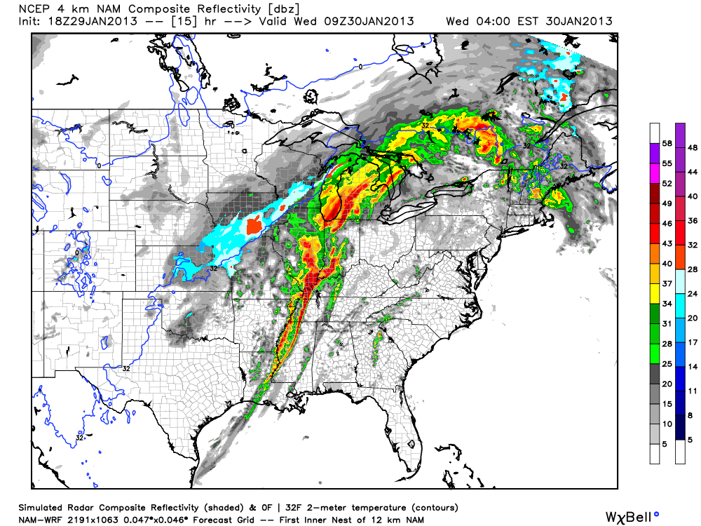 The main storm mode for tonight will be a squall line of storms with embedded rotation in portions of it (AKA what's termed a QLCS). Supercell storms will be possible ahead of the main line of storms too and could easily produce tornadoes if they develop. Tornadoes in QLCS lines of storms like the one we'll have tonight are more difficult to identify on radar since they're embedded within the line. While not as strong as supercell tornadoes, QLCS tornadoes can be strong and cause massive damage in the right environment.
 Also, since winds at 850 mb (about 5,000 feet) will be howling it will not take much for any part of this line of storms to pull these winds down to the surface and create straight-line wind damage. I wouldn't be surprised if folks affected by the worst of these winds thought they were hit by a tornado. I'm hearing the word Derecho being thrown around a bit with regard to how this system will develop tonight. That's certainly a possibility with this system but I think it's a relatively small chance.
Follow me on Twitter and my Facebook page for the latest updates tonight!
Wednesday, January 23, 2013
1/23 - 7:15pm - Rainy End to the Week, Nice Weekend!
 |
| Tonight's low clouds aren't showing up well on infrared satellite imagery. |
Sunday, January 20, 2013
1/20 - 2:45pm - Bitter Cold Air is Arriving Soon!
 Temperatures in the 30's were common last night in West Tennessee and North Mississippi but temperatures are poised to drop much further than that tonight. A dry and relatively marginal cold front is moving through West Tennessee right now and that cold front is the first of two cold shots for the region. This will put lows down into the mid 20's in West Tennessee and lower to mid 30's in North Mississippi as cold air pours in behind the front. This cold air won't allow temperatures to rise much during the day tomorrow either, with highs in the upper 30's closer to Jackson, TN and closer to 50 down toward the Golden Triangle in Mississippi.
Temperatures will moderate during the week thanks to the return of wind flow from the south. This return flow means more moisture in the air across the region. You might guess that this warmer air and more moisture will eventually lead to rain chances... and you'd be right! A low pressure system and associated upper-level shortwave disturbance will track through near the end of the week, bringing rain chances. There's some disagreement between various models over whether this will start on Thursday or Friday. The GFS model's timeline on this is posted below. My guess at this point is that the timeline you see below will be delayed by about 12 hours, so expect rain chances to creep into the region ahead of this low on Thursday afternoon and continue through the night into Friday.

 It's not out of the realm of possibility that a little bit of wintry precipitation may fall on the backside of this system on Friday. If cold air flows in behind a cold front associated with this system fast enough then some of the last few rain showers could mix with or change over to a brief period of snow. The GFS identifies Kentuckiana as being the prime target for this but we all know that model has been trending too warm lately in all the winter weather events we've dealt with. So in my mind, West Tennessee is in a potential area for this mix or snow switchover to occur. We're too early for specifics on this so the forecast will have to be fine-tuned during the week. Stay warm!
Tuesday, January 15, 2013
1/15 - 8pm - Just Plain Rain for Starkville, but Snow Later?

Monday, November 26, 2012
11/26 - 2:15pm - Rainy Start to the Week, Severe to the Southwest

 Had enough of the rain in Starkville this morning and afternoon? Just wait, there's more! An area of moist air ahead of a cold front that will move through tonight is inspiring the development of numerous showers and those will eventually lead to some thunderstorms late tonight. Some of the storms to our southwest could be severe but it's looking more and more like we won't have quite enough moisture and instability to get that kind of storm activity closer to the Golden Triangle. A Slight Risk of severe weather has been issued for areas west of I-55 due to the possibility for severe storms toward Jackson and Vicksburg. Once the cold front sweeps through tonight it'll leave us with cloudy skies for a good chunk of the day tomorrow before things clear out for Wednesday and Thursday.
The weekend will feature some clouds and possibly a shower here and there but overall we'll be seeing one warm end to the month of November as temperatures get close to and surge past 70 degrees! Check out the video below for your detailed CampusConnect forecast.
Monday, November 12, 2012
11/12 - 2pm - A Frigid Fall Return in Progress!

Monday, November 5, 2012
11/5 - 2:15pm - Quick Shot of Rain on the Way in Mississippi


Full sunshine will return to Mississippi by Wednesday and temperatures will recover well into the 60's to 70 or better by the weekend. We'll be watching a storm system make its way through the middle of the country next weekend that has the potential to impact us on Monday of next week. It's not entirely clear how severe the storms we'll have will be but just keep in the back of your mind that we could be off to a stormy start next week. Check out the video below for your complete forecast for the Golden Triangle area.
Monday, October 29, 2012
10/29 - 3:30pm - Superstorm Sandy Coming in, Cool Week in Mississippi
 Hurricane Sandy is a monster storm. That goes without saying. It's about two hours from landfall as of this writing but that won't matter much due to just how incredibly large the wind field is. Tropical storm winds extend for hundreds of miles from the center of the storm making this the largest hurricane ever recorded in the Atlantic Ocean at over 1,000 miles wide. This is big by area, not by wind speed. While the winds extend for an incredible area the winds in general are at Category 1 speeds near 90 mph. For areas in the tropics this may not sound so bad but for the Northeast this is a disaster since winds rarely get up to that strength with storms up there.
 Something that also may be unprecedented here is the extreme snow threat from Sandy for the mountainous regions of West Virginia, Virginia, North Carolina, Tennessee, and Kentucky. Snow totals could be 1 to 2 feet in places when this storm is said and done. The other thing to consider with the size and scope of this storm is the storm surge that continues to roll in. Places like New York City and along the Jersey shore could be dealing with storm surge totals in excess of 11 feet thanks to the pure mass of water that will be coming in with the storm. This will create coastal flooding whereas the high rain totals will contribute to inland flooding. You'll hear about this storm for years to come... 765,000 customers are without power across the Northeast already and this storm is just cranking up.
Monday, October 1, 2012
10/1 - 2pm - Gloomy and Rainy for Now, but Sunny Days are Ahead!
 Finally, a break from the relentless rain this weekend. We're still holding on to a few showers across the northern half of Mississippi and chances for those will stick around until tomorrow morning. After the low that brought us all the rain moves northward during the day tomorrow get ready for the sun to return and for temperatures to go up! A few more clouds will move in toward the weekend as another cold front moves in, but it appears at this time that the front will pass through with out giving us rain. Behind it will be some cooler temperatures so more fall weather will return after all the sunshine and 80's this week. Check out the video below for your complete CampusConnect forecast.
Subscribe to:
Posts (Atom)