The HPC nailed the rain total estimates last night. They were calling for around .25" in Louisville and my rain gauge shows .21" from overnight. That's pretty close!
We're back to our old dry pattern again, this time with highs in the 60's and 70's. We'll be in the mid 60's tomorrow, upper 60's on Thursday, and then back into the 70's for the weekend. No rain chances until at least the middle of next week. On that note, there will be no blog posts or site updates from this Thursday until Wednesday of next week due to my fall vacation.

Tuesday, September 30, 2008
Monday, September 29, 2008
9/29 - 7pm - RAIN!!!
Was that title loud enough? We've got rain, actual rain, on the radar right now heading toward us! This system is still maturing, so its unknown how much rain we'll get exactly. Looking at guidance from the HPC suggests around a quarter of an inch. We'll still have drought problems even after this system comes through. The good part is that we'll end the streak of dry days over the past few weeks, helping some of the plants out that are still flowering. Not to mention the brown grass on everyone's lawn...
We should be dry tomorrow as this system exits late tonight. Temperatures will position themselves in the 60's and 70's over the next week with sunny skies to complement by Thursday.
Hurricane Kyle is history after hitting Nova Scotia. Subtropical Storm (no tropical characteristics) Laura has formed in the Atlantic, luckily with no consequence to land in the forecast track.
Sunday, September 28, 2008
9/28 - 5:30pm - A Beautiful Sunday Afternoon
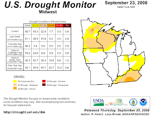
It's difficult to complain about our lack of rain when we've got comfortable temperatures and sunny skies. The fact of the matter is that we're in a moderate drought according to the US Drought Monitor:
We ventured out to Joe Huber Family Farm in Starlight, IN earlier this afternoon to pick apples and boy were they ripe! The nice weather attracted loads of people out to pick pumpkins and apples or simply relax and spend the afternoon shopping and eating.
Hurricane Kyle is barely hanging on as a hurricane right now, with winds at 75mph. It should make landfall in Nova Scotia as a strong tropical storm (technically an extratropical storm due to conversion to a cold-core storm) later tonight. All that's left for Maine right now is a Tropical Storm Warning.
There's still a small chance of rain for us Monday night into Tuesday, but the rest of the week looks dry. Tomorrow should be the last day in the 80's before we slide into the 70's and a few possible days in the 60's this week.
Saturday, September 27, 2008
9/27 - 1:20pm - New Forecast Video
More graphics updates this week... including the 7 day forecast! Tropical Storm Kyle is making its way north to Maine and Canada. While it won't be a monster storm, it will cause some problems up there. It shouldn't be too bad unless the forecast track changes dramatically.
UPDATE: Apparently this is the first Hurricane Watch posted for Maine in 17 years.
UPDATE: Apparently this is the first Hurricane Watch posted for Maine in 17 years.
Friday, September 26, 2008
9/26 - 5pm - TS Kyle, Rain Chances Slim
The low pressure area we've been talking about that's northeast of the Bahamas has now been named Tropical Storm Kyle. Contrary to the model hype earlier in the week, Kyle will not hit New York City or any large populous areas in the Northeast. Its current track grazes the coast of Maine before heading north to Canada:

Kyle will reach hurricane status by this weekend, but probably won't affect much of anything due to its location. It will hit the east coast of Canada as a tropical storm, but it should quiet down pretty quickly after heading inland. Pending any major track variations in the next few days, this should be a pretty forgettable storm.
We should stay dry as usual until Tuesday, when a weak front coming through could generate some showers. Again, optimism is pretty low at this point, so I wouldn't bet on seeing rain on Tuesday. Highs should decrease into the 60's and 70's next week!
Wednesday, September 24, 2008
9/24 - 4pm - Rain.... Please!
On my way home today, I saw that a creek near my house had completely dried up. That gave me a pretty good perspective on how our weather is right now: DRY. We might get a spot of rain Friday with a storm coming onshore in the Carolinas, but that's a stretch at this point. Expect temperatures to spiral down to 80 degrees by Friday after another hot one tomorrow.
That developing area of low pressure near Puerto Rico I talked about yesterday is not as organized as previously expected. Most models are still bringing it up to New England, but now most have it as a tropical storm now instead of a hurricane. Personally, I think this storm will barely materialize due to the possible tropical depression in the Carolinas throwing clouds over the Atlantic. This could limit solar heating on the water and cause interference with the water temperatures needed for this to form. This might have happened to Hurricane Gustav when Tropical Storm Hanna's cloud cover started intermingling with some of Gustav's, which could have made water temperatures drop in a crucial area of development. In any case, we'll have to watch both of these systems into the weekend.
That developing area of low pressure near Puerto Rico I talked about yesterday is not as organized as previously expected. Most models are still bringing it up to New England, but now most have it as a tropical storm now instead of a hurricane. Personally, I think this storm will barely materialize due to the possible tropical depression in the Carolinas throwing clouds over the Atlantic. This could limit solar heating on the water and cause interference with the water temperatures needed for this to form. This might have happened to Hurricane Gustav when Tropical Storm Hanna's cloud cover started intermingling with some of Gustav's, which could have made water temperatures drop in a crucial area of development. In any case, we'll have to watch both of these systems into the weekend.
Tuesday, September 23, 2008
5/18 - 5:30pm - It's a Bit Hot... Could We Really Have a New England Hurricane?
I noticed today as I was sitting outside eating lunch that it's a bit hot for September. Quantitatively, we're around 10 degrees above average for this time of year. We hit 90 degrees, which really hits this point home since our average high is 76 for today. Even though it's dry, it still got a bit uncomfortable in the sun this afternoon.
The GFS is now showing an area low pressure (possibly a tropical storm) coming ashore in North Carolina on Friday, giving us a small chance of rain on the same day. I'm not real optimistic with that right now, so don't get your hopes up for rain anytime soon. Still looks like next Tuesday has a better chance for rain, but that's subject to change this far out.
A few computer models are starting to unnerve some of the weather community today as they show a hurricane hitting New England this weekend:

(NOTE: The CLP5 and XTRP lines on the chart are not to be used as forecast tracks)
As the spaghetti chart says, this isn't even a tropical depression yet. Once it's a tropical storm, it's name will be Kyle (unless the low off of North Carolina beats it). The models are confused as all get out at this point, so none of these forecast tracks should be given more than a glance. As far as strength goes, most are shooting for a tropical storm or Category 1 hurricane. The outlier was the GFDL model which suggested a nasty Category 2 storm near Long Island, but I wouldn't give that prediction the time of day under the circumstances. We just need to sit back and watch this thing during the week.
Monday, September 22, 2008
9/22 - 7:30pm - Welcome to Fall
Ah yes, 'tis the season of changing leaves, sweaters, football, and the occasional early snowstorm. Today was the first day of Fall 2008 and nobody could really tell. A continuation of our dry, nearly drought weather has made that Summer feeling in the air stick around a while longer. We're slated to be dry until possibly the first week of October according to the GFS. Even then it looks doubtful that we'll see much if any rain at all! At least our mornings and evenings in the lower 60's have made things feel a little more fall-ish.
An area of low pressure near Puerto Rico is making weather-watchers like myself cast a weary eye to the Caribbean. It is not yet a tropical depression, but it's getting fairly close according to the NHC. Some models were and still are taking this storm near the NYC area, prompting concern that this could be like a storm that hit New York on this day in 1938. Since it's late in the season and the water is not as warm in that vicinity comparted to the Gulf, I really wouldn't worry about this storm being a big mess like the one in '38. It is important that we keep an eye on it though in case it throws in some late season surprises.
Still 11,000 without power in Louisville as of 4:30pm today. It boggles my mind that we still have people without power from last Sunday's wind storm. That right there should tell you that this was a phenomenon that many of us will only see once in a lifetime. After returning to school today, an outpouring of many stories and experiences reverberated throughout the halls. I heard some say they didn't even lose power or see all that much wind. Those experiences were in the minority as most of the people I talked to said they were without power until this past weekend, with a few still without power. Many also had to clear out tree limbs and repair damage caused to their homes. We only lost a half dozen shingles and a couple limbs fell in our woods, so I consider myself lucky after hearing what others had to go through.
Thanks again for all the comments concerning my acceptance into MSU yesterday.
Sunday, September 21, 2008
9/21 - 2:30pm - Boring Weather, Big Announcement
I'll start with the big announcement: I have been accepted into Mississippi State University for the fall of 2009. This means I'm off to Starkville, MS to complete my professional meteorology degree with an emphasis in broadcasting next August. For those who don't know, Mississippi State has one of the best, if not the best, meteorology programs in the South. I visited their facilities in July of this year and was thoroughly impressed with what they had to offer, especially in the meteorology department. The professors and students there are just as nuts about the weather as I am!
Moving on to our boring weather... We might get a spotty shower around here this afternoon since a few of them have formed to our south. The rest of the week looks dry and sunny, with highs reaching into the mid 80's.
Moving on to our boring weather... We might get a spotty shower around here this afternoon since a few of them have formed to our south. The rest of the week looks dry and sunny, with highs reaching into the mid 80's.
Saturday, September 20, 2008
9/20 - 12pm - New Forecast Video
I have a nasty cold and lost my voice, but I was just barely able to crank out a video today before the whole voice box went down the tubes. I've made a couple small graphical enhancements to the video and the 7-day forecast, so look for those. This week should be much calmer than last week.
Friday, September 19, 2008
9/19 - 1pm - Warming Up a Bit
Mid 80's will stick around here for the weekend as the sunny and dry weather continues. A small system to our south will bring showers to downstate Kentucky, but no such luck for us. We really do need the rain. At least the weather is pristine for the Ryder Cup!
We're down to 98,000 customers without power from LG&E, which is still a huge number considering the winds rolled through on Sunday. JCPS will have school on Monday since only 14 schools lack power and generators can be used for them. The school year will be extended to June 1st to accommodate the missed days. With a possibly nasty winter on the way, it's doubtful that this will be the final time this year that the last day of school is moved.
We're down to 98,000 customers without power from LG&E, which is still a huge number considering the winds rolled through on Sunday. JCPS will have school on Monday since only 14 schools lack power and generators can be used for them. The school year will be extended to June 1st to accommodate the missed days. With a possibly nasty winter on the way, it's doubtful that this will be the final time this year that the last day of school is moved.
Thursday, September 18, 2008
9/18 - 5:30pm - Dry and Powerless
We're still sitting at 129,000 LG&E customers without power in the Metro, with 30 of those being JCPS buildings. Luckily the weather is quiet and it isn't terribly warm.
With the Ryder Cup going on this week, we want to make sure the weather is perfect. I can assure you that it will be beautiful during this stretch, but we need rain badly. The next chance of rain could be as far away as a couple weeks from now, as the GFS has a dry and high pressure dominant pattern setting in.
With this dry weather, the temperatures have risen slightly in the forecast. We're looking at highs in the lower 80's for the next week as opposed to 70's. The air will be a bit stagnant for the next couple weeks, so we could see air quality problems as well.
Wednesday, September 17, 2008
9/17 - 4pm - We're Back in Business!
The power came back on at my house a couple hours ago much to my surprise. Since we live on the Jefferson/Spencer County border, we're usually the tail end last people to get power restored after a storm. Three days of "camping" inside my house is finally over and normal life resumes... unless you go to a JCPS school (which I do). JCPS is canceling for the rest of this week due to more than 40 schools without power. Things should return to normal by Monday and classes should resume.
That was some wind event. I can't even call it a storm because barely a drop of rain fell with it! Many are still puzzled as to why this happened, and here's why: Remnants from Hurricane Ike slid northwest of here on Sunday morning as a cold front intercepted it and made it increase in speed. As that was happening, a low level jet of around 70-90mph was making itself known a few thousand feet off the ground. Once the air started mixing from the ground into that jet, high wind gusts got to our altitude and wreaked havoc. That's it in a nutshell.
With not a drop of rain in the forecast for the next week, highs should stay in the lower 80's. Our next chance of rain could be as far away as next Tuesday... boy do we need it!
Tuesday, September 16, 2008
Monday, September 15, 2008
Sunday, September 14, 2008
9/14 - 2pm - WIND UPDATE
We've been recording gusts up to 40mph over the last hour at my house. The power is flickering like crazy here so this will be short. We're under a High Wind Warning until 3pm this afternoon. Higher gusts of near 60mph could be possible during the next hour as more of what's left of Ike comes through. No appreciable rain on the radar right now, just some small sprinkles here and there. Maybe we'll get lucky and not have any heavy storms this afternoon... but we do need the rain. The winds should die down tonight at around 8pm when the Wind Advisory expires.
9/14 - 12pm - Hold on to Your Hats!
A Wind Advisory is in effect until 8pm tonight. Gusts of up to 40mph are expected. The SPC has us in a SLIGHT Risk for severe storms and a 5% chance of tornadoes, which means a couple isolated tornadoes could pop up around the region. While Ike's remains are barreling toward us, there's a gap in the system that will come through here unless there's more development later today. If we do get that gap in the storms, then we're going to be dry today. Quite honestly I think there will more storms developing in that gap as heating gets going today, so be ready for those.
After a rocky start yesterday with domain name issues, my new website is now fully functional and online. Check it out at http://ryanweather.org.
After a rocky start yesterday with domain name issues, my new website is now fully functional and online. Check it out at http://ryanweather.org.
Saturday, September 13, 2008
9/13 - 1pm - New Forecast Video, New Website
A rainy couple of days ahead and then clearing for the workweek!
My new website is now online. Just go to ryanweather.org and take a look at the changes! You'll get a "Location Change" redirect page for the next few hours as the servers switch my domain name over, but all you have to do is wait 5 seconds and you're there!
My new website is now online. Just go to ryanweather.org and take a look at the changes! You'll get a "Location Change" redirect page for the next few hours as the servers switch my domain name over, but all you have to do is wait 5 seconds and you're there!
Friday, September 12, 2008
9/12 - 8:30pm - Ike's Messing With Texas. Big Time.
It may only be a Category 2, but Hurricane Ike sure is packing a punch to the Galveston/Houston area of Texas. This is a region right at sea-level, especially around Galveston Island. Add to that a 20+ foot storm surge and you've got a flooding problem of monstrous proportion. 40 percent of Galveston Island's residents have stayed behind, even after a ghastly warning from the Houston NWS Office:

Category 3 winds begin at 111mph, so it would only take a nudge in strength to have this upgraded. I'm noticing some intense re-wrapping near the eye going on in the IR satellite loop. I think this could signal some strengthening, but it's not for sure at this point. We'll see if the NHC agrees on the next outlook.
Landfall should take place tomorrow morning on Galveston Island. Let's hope this doesn't strengthen much overnight.
We're in for a small chance of showers for the remainder of tonight and tomorrow. It seems like the heavier rains will now goes further west on Sunday than once thought, so expect rain totals from .5" to 1" on Sunday into Monday morning. All next week will be in the 70's or lower 80's at most.
Get ready for the new Ryan Weather website tomorrow! Check your bookmarks... If you have a bookmark or link that reads "http://ryanweather.googlepages.com", please change that over to http://www.ryanweather.org, otherwise it will not work after tomorrow morning. This is changing because I am dropping Google as my hosting service and the site will now be natively found at ryanweather.org instead of being redirected. If you normally visit Ryan Weather through www.ryanweather.org, then you're set to go!
PERSONS NOT HEEDING EVACUATION ORDERS IN SINGLE FAMILY ONE OR TWO STORY HOMES MAY FACE CERTAIN DEATH.That would certainly be enough to get me out of there! Ike's winds are at 110mph right now, which is a strong Category 2 storm:

Category 3 winds begin at 111mph, so it would only take a nudge in strength to have this upgraded. I'm noticing some intense re-wrapping near the eye going on in the IR satellite loop. I think this could signal some strengthening, but it's not for sure at this point. We'll see if the NHC agrees on the next outlook.
Landfall should take place tomorrow morning on Galveston Island. Let's hope this doesn't strengthen much overnight.
We're in for a small chance of showers for the remainder of tonight and tomorrow. It seems like the heavier rains will now goes further west on Sunday than once thought, so expect rain totals from .5" to 1" on Sunday into Monday morning. All next week will be in the 70's or lower 80's at most.
Get ready for the new Ryan Weather website tomorrow! Check your bookmarks... If you have a bookmark or link that reads "http://ryanweather.googlepages.com", please change that over to http://www.ryanweather.org, otherwise it will not work after tomorrow morning. This is changing because I am dropping Google as my hosting service and the site will now be natively found at ryanweather.org instead of being redirected. If you normally visit Ryan Weather through www.ryanweather.org, then you're set to go!
Thursday, September 11, 2008
9/11 - 9:30pm - Houston, We Have a Hurricane
Sorry about the late post today and the non post on Tuesday... crazy week at school.
Hurricane Ike threw a curve ball on landfall in the models last night. Here's what surprised me as I awoke today:

Yep, that's Houston right in the bull's eye there. Yesterday before the late evening update, it seemed as if Corpus Christi would be the target, but this northward shift has changed the logistics of just about every aspect of this storm. Current estimates put the strength at Category 3 for landfall, down from some Cat 4 estimates late yesterday. The pressure is increasing right now meaning the storm is weakening slightly, but the water gets warmer as it nears the Texas Coast. Something that caught my attention was how large in area the storm is. Take a look at the latest satellite image:

This thing takes up nearly all of the Gulf of Mexico in size! So while it may not be a record-breaking storm in strength, it definitely will be seen and felt by many as it moves into the United States.
As moist air from Ike is funneled in here over the the next few days, rain will be on the increase. Expect showers and thunderstorms to begin tonight and continue off and on tomorrow. As a warm front finally comes through early Saturday rain will also accompany it in the morning. It should taper off for the most part in the afternoon to early evening hours. The gut-busting rain could come Sunday night into early Monday as Ike's remnants blast through here. If the HPC is right, we could get upwards of 3" of rain, or even more if this system shifts east. The SPC says we could have an isolated tornado risk as what's left of Ike comes through due to possible instability and already present rotation in the storm. This is just a guess at this point according to them, so don't get too wrapped up in that yep.
After all this warm front/Ike mess is gone on Monday afternoon, we'll be left with highs in the 70's for a good part of next week. How's that for a reward after all this nasty weather?
Wednesday, September 10, 2008
9/10 - 4:30pm - Rain's Coming and so is Ike
Looks like we've got a pretty decent chance of rain starting tomorrow night and continuing through the weekend. While it won't rain that hard or for the whole time period, I think it'll be enough to perk up the grass around here. Just bring the umbrella along over the next few days.
Did anyone get outside early this morning? Brrr! That was the coldest low I think we've had since Spring and that could happen again tonight into tomorrow as well. As the rain comes in tomorrow evening for the weekend, our lows should be back in the upper 60's due to the moisture in the air. Highs should only top out in the lower 80's this weekend after a high in the mid 80's tomorrow.
Hurricane Ike looks like it will make landfall near Corpus Christi, TX as a Category 3 storm. The spaghetti chart looks very similar to the NHC's guidance, so I really don't need to post that:

Obviously this storm will cause quite a bit of flooding and inevitable wind damage on the Texas coast, so watch out for that if you have interests in that area. We could get some rain from Ike early next week, but the models are having difficulty deciding whether that is going to be true or not.
Monday, September 8, 2008
9/8 - 4:30pm - Ike Could be a Texan
It looks like we've got a better idea for a landfall location than yesterday. The current NHC guidance and spaghetti chart all take it to the Texas Gulf Coast as a Category 3 before landfall:


(NOTE: The CLP5 and XTRP lines on the chart are not to be used as forecast tracks)
This is not a final forecast for landfall by any means. This storm still has to navigate through the terrain of Cuba once more before it pops out into the Gulf. Models are sometimes thrown off by how terrain affects a storm, so we'll watch for that. After it exits Cuba we should have a fairly firm idea of where this storm will go.
We've got a pretty good chance for rain tonight, although it won't be a great amount. The rain should be out of here by tomorrow afternoon, which sets us up for a clear Tuesday and Wednesday. Rain chances return by Thursday, with temperatures ranging from the upper 70's to mid 80's for the week.
Sunday, September 7, 2008
9/7 - 2pm - Ike's in Cuba, 500th Post!
Hurricane Ike is still very strong as a Category 4 storm, getting ready to hit Cuba lengthwise. After the damage it caused in Haiti and the Turks and Caicos, Cuba won't be an exception. It should make landfall tonight and weaken to a Category 1 by the time it exits Cuba on Tuesday. Still no details on landfall other than it will be on the Gulf Coast in Texas or Louisiana:


(NOTE: The CLP5 and XTRP lines on the spaghetti chart are not to be used as forecast tracks)
So, we'll have to really watch what Ike does in terms of direction and strength this week.
We're still on track here for a chance of rain here on Tuesday. Temperatures should be in the low 80's all week, with tomorrow and Thursday being the exception in the upper 80's.
By the way, this is my 500th post for those keeping track. That's pretty good for just under 2 years of blogging I'd say. On that note... the Ryan Weather website is receiving a major overhaul. It's being rebuilt from scratch and I'm dropping Google Pages as my host, so you won't see anymore outages due to bandwidth issues. Expect to see the new site in the next couple of weeks if not earlier.
Saturday, September 6, 2008
9/6 - 2pm - New Video Forecast
Looks like a cool week ahead with some rain on Tuesday and Friday. Keep your eye on Hurricane Ike, it looks like it will venture into the Gulf of Mexico.
Friday, September 5, 2008
9/5 - 6pm - I (Don't) Like Ike
First off, the drizzle, mist, or whatever you want to call it will end later tonight and a dry weekend will be in the cards. Expect temperatures to be in the mid 80's for this weekend and through Tuesday, when we should see a nice drop in temperature for the week ahead.
The tropics are again stealing the weather show as Hanna gets ready to come ashore as a strong tropical storm and Ike takes an unexpected turn in the models.
Here's Hanna's track:

With winds at 70mph right now, Hanna is a strong tropical storm just under Category 1 hurricane status. It should weaken just before it hits land, so I really think this will be a rain maker and flooding issue more than a wind maker.
Hurricane Ike is a different story. Yesterday I reported on the blog that it was still in limbo as to whether the storm would even hit land. Here's what happened today in its track:

Yep, that's a Category 3 Ike trying to wedge itself between Florida and Cuba. The NHC's outlook has it weakening a bit this weekend before strengthening to a Category 4 by next week, so we'll really have to look at this storm seriously. This shift was caused by a forecast weakening of high pressure near the Gulf of Mexico coupled with some weakening of high pressure over Florida causing a northward turn near Tuesday. Obviously it's too far out to tell if this series of weakening will actually occur and to what effect Cuba and Florida will have on the storm's strength. Here's the latest spaghetti chart:

(NOTE: The CLP5 and XTRP lines on the chart are not to be used as forecast tracks)
What a crazy couple of weeks it's been in the tropics!
Thursday, September 4, 2008
9/4 - 4:30pm - Gustav Moisture, Hanna and Ike
So far we haven't been to lucky with the moisture left over from Gustav. It's sliding northeast and is positioned to our west, so we're not going to get too much rain out of it. Nevertheless, a line of showers will come through tonight and a chance for rain exists through tomorrow night as well. No more 90's for the rest of the week and into next week!
Here's an update on Hanna and Ike:

Hannah will briefly reach Category 1 status before making landfall in North Carolina this weekend. Here's the spaghetti chart for it:

(NOTE: The CLP5 and XTRP lines on the chart are not to be used as forecast tracks)
Hurricane Ike is at a Category 4 right now and is expected to weaken to a Category 2 tomorrow. It's forecast to strengthen near the Bahamas this weekend.

There's no real consensus or guidance on whether it will hit land yet, but it doesn't look like it'll go into the Gulf of Mexico at this point:

Wednesday, September 3, 2008
9/3 - 9pm - Rain! It's About Time!
You can thank what's left of Mr. Gustav and an approaching cold front for our isolated downpours today. The downtown area received a good soaking at around 10am this morning and we got hit at home around 4:30pm this afternoon. I really didn't think any rain would happen this early in the week, but Gustav trended north quicker than expected and an interacting cold front only added more of a kick to those spotty downpours. These two features will continue to push through tomorrow, so expect more widespread rains as they get closer. The rain should be out of here by late Friday, so we'll have a dry weekend to look forward to. I think we'll also kick out the 90's after tomorrow as well, making for a cooler week in the 80's.
Tropical Storm Hanna will become a hurricane soon, with a projected landfall near North Carolina's Outer Banks:

This storm is expected to reach a Category 2 with Category 3 status not out of the question. If indeed this storm does get to a 2 or 3, then it would have a pretty major effect on the North Carolina coastline. Hurricane Ike (yeah, that was a quick upgrade) is now a Category 3 already with 115mph winds. We're going to have to really watch this one because it's on a path that could take it between Florida and Cuba and right into the Gulf of Mexico, which is never a good scenario:

I'll post spaghetti charts tomorrow for these storms. Tropical Storm Josephine is still churning in the Atlantic, but it's expected to weaken into a depression and I don't think this will be a threat to land at this point.
Tuesday, September 2, 2008
9/2 - 8:30pm - From the Lexington Herald-Leader
The Lexington Herald-Leader has posted a blurb about The Weather Channel contest that I talked about last week... click here. Kudos to them for picking up the story! It'll be interesting to see if this gets picked up by any of the other papers.
I must say congratulations to the grand prize winner Dorsey Franklin from Jamestown, Kentucky. Her winning entry was a neat hurricane coverage video with lots of weather jargon and explanations. Great to see a fellow Kentuckian involved in weather!
I must say congratulations to the grand prize winner Dorsey Franklin from Jamestown, Kentucky. Her winning entry was a neat hurricane coverage video with lots of weather jargon and explanations. Great to see a fellow Kentuckian involved in weather!
9/2 - 5:15pm - Hot and Dry!
(NOTE: I really do appreciate everyone's comments to the blog posts, but keep them respectful and professional please.)
It's 93 degrees at the airport with a dewpoint at 65. While the humidity isn't all that impressive, it's just enough to make it feel pretty sticky out there. With the little amount of rain we've had for nearly the last month, the heat will only feed off of the dry ground. Hopefully we can curtail the temperature this weekend by adding in a small chance of rain on Friday. That's about all we can hope for right now!
Clearing out some unfinished business from Gustav... It was pretty evident that Gustav would not come ashore as no more than a Category 2 or 3 the night before, but a few media outlets seemed to keep the Cat 4 or 5 possibility in the limelight. The storm was simply too close to land and cooler water for any further development by about 4pm the day before. As always, I recommend going straight to the source, the National Hurricane Center. While they're not always 100% correct, I can assure you that they are more unbiased and less sensationalist than other sources. John Belski seemed to pick up on this as well... click here.
As for Hanna and Ike, here's their projected paths:


Tropical Storm Josephine has formed as well, but it's too far off to really tell where it will go. I'll post maps on that one at a later point in time.
Monday, September 1, 2008
9/1 - 4pm - Gustav Weakens, Levees Hold, More Storms to Come
Gustav has weakened to a Category 1 with winds pushing up to 90mph right now. There are mass power outages in the Louisiana/Mississippi area, including New Orleans. That's to be expected with the winds that came through. Here's some great news: the levees are holding in New Orleans. Even though they are being over topped by the storm surge, they are at least not failing and holding most of the water back. There has been some flooding in the Industrial Canal area of New Orleans, but that seems to be an isolated case at this point. The levees are holding in that area, but they're unfinished and water is sloshing over them. Let's hope that the levees hold for the remainder of this storm, especially with the Mississippi River now being affected.
The track from the NHC brings the remains of Gustav into Oklahoma now instead of parking it in Texas. This raises the possibility for some drenching rains here, especially if this meets up with a cold front expected to stall out over us early this weekend.
Now, here's some bad news. We're going to add two names to the family of storms in the Gulf and Atlantic. Hurricane Hanna was upgraded from a tropical storm this morning and Tropical Depression 9, soon to be Tropical Storm Ike, is on it's way. Hanna is going to impact North or South Carolina this weekend and Ike is going to try to aim for the Bahamas as a hurricane by this weekend as well. I'll get maps and models up on those tomorrow after Gustav stops causing such a stir.
9/1 - 10:30am - Gustav Now Category 2
The only kicker to my title is that the storm only dropped 5mph to reach a Category 2, which puts winds still around 110mph. But, any weakening is good in this situation.
Here's the track from the NHC... landfall by this afternoon:

New Orleans will most likely see Category 1 hurricane force winds with no word on exactly what is going to happen with the storm surge. I've heard estimates from 8 feet all the way to 15 feet, so we'll have to wait and see. Obviously the towns around the area of landfall like Houma, LA and Morgan City, LA are going to see the full force of this storm.
There have been a great deal of tornado warnings posted both overnight and this morning in the Gulf Coast due to some potential rotation within some of these rain bands, but only one tornado has been reported from western Mississippi to the SPC.
As for us, we're going to stay hot and dry until this weekend. Highs will top out at around 93-94 in the suburbs and maybe up to 95 degrees in the city.
Subscribe to:
Posts (Atom)