


 After a couple days of 96 degree weather in Louisville, we're on-track for a cool-down today. How much of a cool-down? Try four degrees. Yep, it's going to be another hot one today. With dew points in the lower 70's today, the heat and humidity will combine to produce heat index values at or above 100. No Heat Advisory will be issued, but it'll still be hot enough to cause problems if you're not hydrated. The other feature of our weather today will be the chance for some showers and thunderstorms around the region. A cool front that's situated just north of the Ohio River will provide a trigger for these scattered storms today, which should begin to form this afternoon. We're just outside of a Slight Risk area for severe weather from the SPC, but I think a few storms around the region could get strong due to increased atmospheric instability and a light touch of shear. A small daily chance for storms will exist through the rest of the week with temperatures hanging around in the lower 90's.
Today: Mostly sunny and hot, with a high near 121. Calm wind becoming south between 4 and 7 mph.


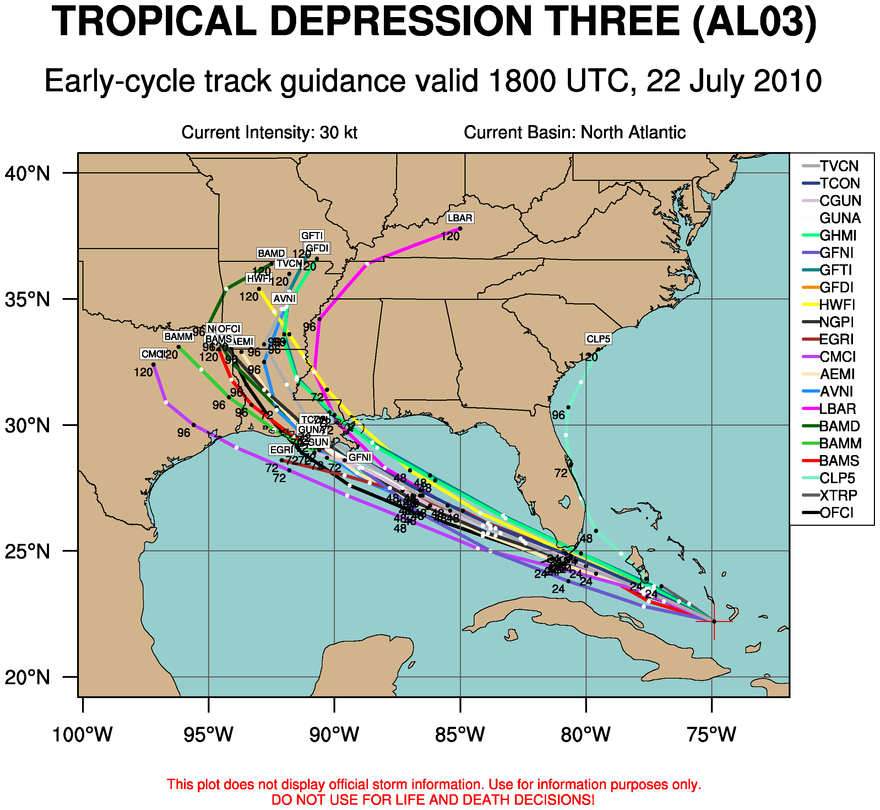 National Hurricane Center and the spaghetti chart (a compilation of various computer model forecast tracks - see right image). We'll have to keep a close eye on any intensification of this storm, especially when it exits the Florida Peninsula and heads into the Gulf.
 The Storm Prediction Center has issued a SLIGHT Risk for severe weather this evening, with the main threat to the Louisville area being high winds. A squall line of storms has been developing this afternoon to our west and should be coming through here sometime after 4:15pm. An embedded cell within this line near English, Indiana
  has reached severe limits and I do expect this line to strengthen given the highly unstable environment and moisture available in the region. Once this line comes through, we may see a few scattered storms develop tonight due to enhancement by the low-level jet.
 We topped out at 95 degrees today in Louisville, which was two degrees short of being the hottest day of the year so far. Higher dew points also stayed to our west today as well, so things were not as bad as they could have been. We've had 31 days this year with 90 degree temperatures or higher in town, and I'm sure we'll be able to break 40. Compare that with 13 last year.

 We had quite a soaking over the weekend in most places around Louisville, but I was really expecting today to be the bigger event. As the term "chance" implies, some forecasts succeed while others fail. A few scattered storms formed last night in Western Indiana that were expected to become more widespread and hit Kentuckiana this morning, but they simply couldn't get organized. The rain that formed this afternoon (as you can see in the left radar image) stayed to our south, but storms that are developing in Missouri and West Kentucky right now may have enough juice to make it here early tomorrow morning. We definitely can't say that moisture will be a limiting factor in the evolution of these storms as dew points right now in Louisville are in the lower 70's. That's pretty humid! We'll see another rain chance on Tuesday before a cool front passes through on Wednesday. You would think that temperatures would decrease after the passage of a cool front, but hot air will rapidly build back into the area after it goes through. Temperatures will soar into the middle and upper 90's for Wednesday and Thursday respectively.
 We may have had some rain this weekend, but overall the ground is still pretty dry in Louisville. Soil moisture levels have quite an influence on the air temperature, but they're especially crucial when you're talking about the heat of summer. If we don't see any rain tonight and tomorrow, I have a feeling that 100 degrees won't be too far from our grasp. A location or two, most likely in an area with lots of concrete, could get within a degree of 100 on Thursday. Next week has more potential in my mind because there is no appreciable rain in the computer models for the entire week and high pressure to our east will cause hot air from the south to flow into our neck of the woods. Should be interesting to see how it develops!


 Temperatures in the Northeast are extremely hot today. High pressure that has settled over the area is allowing things to really heat up. Temperatures near Philadelphia are around 100 degrees right now and numerous heat advisories and excessive heat warnings are in place.
 As high pressure persists around the Ohio Valley, we'll be seeing wonderful July 4th weather. Temperatures will top out around 92 tomorrow in Louisville with dew points in the mid 60's. That translates to a warm day without the oppressive humidity we saw last week. Most high-resolution computer models are placing a chance for some isolated rain showers in here tomorrow afternoon, but I don't think the probability is high enough to warrant any change in plans for Independence Day activities. Be sure to use sunscreen tomorrow if you participate in any outdoor festivities as the UV index will be high.
 Hurricane Alex made landfall in Mexico last night as a category 2 storm, which was the strongest June hurricane since 1966. causing widespread damage and flooding in areas around Monterrey. Rivers that had dried up in the area became active yesterday, sweeping away cars and unfortunately people. Two have died in that area after 16 inches of rain fell from the storm, which is now a weakening tropical storm. On the US side of the border, Alex caused mainly flooding issues for areas in Texas near Brownsville. A tornado watch is in effect for South Texas until 8pm CDT as the storm weakens and moves west. Hit the links below to read more about Alex's impact on Mexico and Texas.