

Showing posts with label tornado. Show all posts
Showing posts with label tornado. Show all posts
Wednesday, April 17, 2013
4/17 - 6:35pm - Severe Weather Tomorrow in Mississippi
Thursday, April 11, 2013
4/11 - 7pm - Rough Day of Severe Weather, Sunshine to Come

Tuesday, January 29, 2013
1/29 - 5:45pm - Serious Severe Weather Concerns Tonight
Latest Severe Weather Updates
 A severe weather setup that we see normally in the springtime is about to unfold on this late January night across a large expanse of the Southeast. While not "unprecedented" or "once-in-a-lifetime", this outbreak is going to impact quite a few people and it's important that everyone have what they need to be prepared and safe. This post is mainly for folks in North Mississippi and West Tennessee, but you can figure out pretty well how you'll be affected if you're not in these areas by some of the maps and information below. Everyone needs to be aware of what's going on because this will be happening at a very bad time of night when even the night owls are asleep.
Fast Facts
 A MODERATE Risk of severe weather has been issued by the Storm Prediction Center for the overnight hours in West Tennessee and most of North Mississippi. Tornadoes, damaging winds, and hail are all on the table for these areas as storms move through. Even though places like the Golden Triangle in Mississippi are just outside of the Moderate Risk area I would treat this as if you were in it because these storms are going to be very, very strong still as they move through this region. Please, please, please have a weather radio or smartphone app that's armed and ready to alert you if a Tornado Warning is issued for your location tonight. This will be hitting when most people are asleep so it's a very dangerous situation.
Timing - North MS and West TN
8pm - Midnight - Small chance for some isolated storms. These would carry a tornado, wind, and hail threat.
Midnight - 2am - Slightly better chance for isolated storms, small line of storms may try to form ahead of main line.
2am - 7am - Main line of severe thunderstorms moves through. This will affect everyone. Tornadoes, severe damaging winds, and hail are a good bet during this time.
Discussion
 A line of storms stretches from the Great Lakes to Texas right now and will continue to move eastward through the evening. A few reports of severe weather have come in already from this but the main show will be overnight as this line of storms encounters a more rich environment for severe weather.
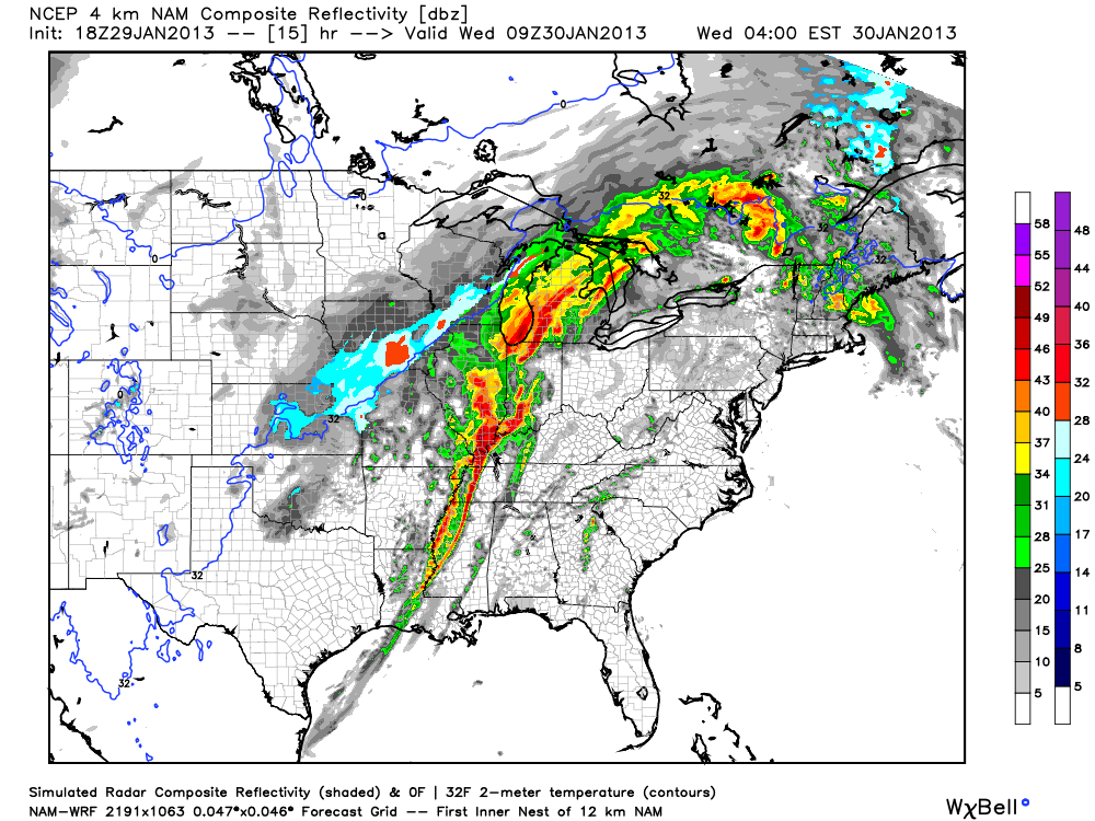 The main storm mode for tonight will be a squall line of storms with embedded rotation in portions of it (AKA what's termed a QLCS). Supercell storms will be possible ahead of the main line of storms too and could easily produce tornadoes if they develop. Tornadoes in QLCS lines of storms like the one we'll have tonight are more difficult to identify on radar since they're embedded within the line. While not as strong as supercell tornadoes, QLCS tornadoes can be strong and cause massive damage in the right environment.
 Also, since winds at 850 mb (about 5,000 feet) will be howling it will not take much for any part of this line of storms to pull these winds down to the surface and create straight-line wind damage. I wouldn't be surprised if folks affected by the worst of these winds thought they were hit by a tornado. I'm hearing the word Derecho being thrown around a bit with regard to how this system will develop tonight. That's certainly a possibility with this system but I think it's a relatively small chance.
Follow me on Twitter and my Facebook page for the latest updates tonight!
Monday, August 27, 2012
8/27 - 9:30pm - Update on Isaac's Expected Gulf Coast Landfall


 How long will it be until this dry air is finished working through the
storm? Probably a few more hours, possibly lasting into the early
morning hours tomorrow if current model forecasts are correct. Speaking
of models, the current track from the National Hurricane Center takes
Isaac right into the Eastern Louisiana/Mississippi Coast areas late
tomorrow night into early Wednesday morning as a weak Category 2 storm
with 100 mph winds. With the lack of organization we're seeing right now
it may only be a Category 1 at landfall. The latest computer model
tracks, the spaghetti plots as you've probably heard
about and seen over the past few days, have tightened up on a landfall
location somewhere around New Orleans. It's worth noting that some of
these models are now trending eastward after a massive amount of
successive westward jogs in recent days. It doesn't appear that this
landfall will take place further east than Biloxi, Mississippi given the
current motion of the storm and model data, but the exact landfall
location won't be the big story with this storm.
How long will it be until this dry air is finished working through the
storm? Probably a few more hours, possibly lasting into the early
morning hours tomorrow if current model forecasts are correct. Speaking
of models, the current track from the National Hurricane Center takes
Isaac right into the Eastern Louisiana/Mississippi Coast areas late
tomorrow night into early Wednesday morning as a weak Category 2 storm
with 100 mph winds. With the lack of organization we're seeing right now
it may only be a Category 1 at landfall. The latest computer model
tracks, the spaghetti plots as you've probably heard
about and seen over the past few days, have tightened up on a landfall
location somewhere around New Orleans. It's worth noting that some of
these models are now trending eastward after a massive amount of
successive westward jogs in recent days. It doesn't appear that this
landfall will take place further east than Biloxi, Mississippi given the
current motion of the storm and model data, but the exact landfall
location won't be the big story with this storm. |
| Storm surge exceedance probabilities |
 |
| Rainfall through 7pm CDT Saturday |

So overall we're not looking at Isaac to be a major hurricane at landfall, but the effects from it will be widespread due to it's large size. It's a good thing that folks in a wide area are preparing for this storm since it could be a long haul given the slow motion that's expected from it.
Saturday, July 7, 2012
7/7 - 10:30pm - Massive Heat Wave Ends with Storms
 Today capped off the longest, hottest stretch of weather in Louisville that most people can remember. Today's 106° high at Louisville International Airport was the hottest it's been since July 14th, 1936 when it got to 107°. That temperature is Louisville's all-time record high and if we didn't have as many clouds as we did this afternoon in the city we would have met or broken it. This ends nine days of 100°+ weather, which is the third-longest stretch of triple digits ever recorded according to NWS Louisville.
 The main threats from these storms will be wind and hail, but there could also be a threat for some rotating storms too. While winds don't look favorable for any sort of big tornado problems tomorrow, a couple of these rotating storms may get just enough juice to put down a brief spin-up. EHI values in the adjacent image take into account both instability and helicity, which is a product of wind shear. The elevated values you see are powered mostly by instability and just a little bit of helicity, so again, winds aren't that favorable here. The Louisville area is no stranger to summertime tornadoes as you may remember a series of four of them that touched down in late June of last year.
Tuesday, June 26, 2012
6/26 - 10:40am MDT - Another Day, Another State


Keep up with our chase today by following me on Twitter and Facebook!
Saturday, May 26, 2012
5/26 - 11:35pm EDT - The Journey Home

 The chase began near La Crosse, Kansas where we followed a couple of developing supercells that had quite a bit of dust kicking out from under their ouflow. We followed a right-moving cell for quite some time, all the way to Bunker Hill, Kansas, as it cycled through weak and strong stages. This is the storm that produced the aforementioned string-like funnel cloud. Many a wall cloud came from this storm, but it was just too disorganized of a structure to get things going for a tornado. The storm that would form quite a few tornadoes (including an EF2-rated one near... you guessed it... La Crosse, Kansas) finally got its act together just to our southwest near sunset, but we had to bug out just as that was happening because we were so far away from Oklahoma City where we needed to be so that our tour guests could fly out. It's really too bad that we had to miss these tornadoes, but that's part of having to deal with the logistics of tour guests and the unpredictability of storm chasing. The storm structures were certainly spectacular though and we did see quite a few gustnadoes and dust being blow around. Video from these storms will be processed and uploaded tomorrow night when I get some time.
 Yesterday and today have really been the same day for me. After we finished chasing in Central Kansas we had to make a bee line for Oklahoma City, where we made it in to town just after 3:30am this morning. My flight left at 7:35am this morning meaning I had to be at the airport around 6am, so I actually had no time to sleep in the interim. It's good to be back home in Louisville after being so tired! During these three weeks I've been with Storm Chasing Adventure Tours this month we've gone 8,383 miles across Oklahoma, Texas, New Mexico, Colorado, Nebraska, South Dakota, Iowa, Missouri, and Kansas. There are so many areas that we visited this season that I've never been to before, especially near the Mexican border in Laredo, Texas and Big Bend National Park. But I'm not done yet. After a few weeks at home and abroad, I'll be back out storm chasing again for a week starting on June 23rd and going through the 30th. This is typically a time where severe weather is found up north in the Dakotas and Nebraska, so I'll be flying out to Denver in about a month's time to meet up with everyone. A photo album of this year's chase so far can be found on my Flickr and Facebook accounts along with the slideshow below:
Friday, May 25, 2012
5/25 - 11:50am CDT - A Grand Finale


Follow up-to-the-minute reports on our chase on my Twitter and Facebook accounts!
Thursday, May 24, 2012
5/24 - 12:35am CDT - We're in... Iowa?


 Tomorrow will likely be a travel day back to Kansas or Southern Nebraska as we await Friday's potential chase setup. Storms tomorrow will be up near the Great Lakes in Wisconsin and Michigan and we just don't chase there due to the distance from the Plains and lack of good chase environment up there. Strong capping should keep storms from going up in the central and southern Plains, but we'll keep an eye on that in case that changes. Friday's setup may be decent if capping aloft doesn't ruin it. A deepening trough out in California and hopefully some better moisture return from the Gulf of Mexico should create potential for severe weather. A strengthening low in Southeast Colorado/Southwest Kansas should provide ample surface wind support for rotating storms should this pan out as forecast. The Storm Prediction Center already has a 5% risk area for this in their 3-day severe weather outlook. I'm crossing my fingers that this setup will yield some good storms because Friday is my last day chasing in the Plains until late June!
Follow me on Twitter and Facebook for updates this week.
Wednesday, May 23, 2012
5/23 - 11:50am CDT - Nebraska or Colorado?


Follow up-to-the-minute updates today on my Twitter and Facebook accounts!
Tuesday, May 22, 2012
5/22 - 9:45am MDT - Nebraska Here We Come!


Follow me on Twitter and Facebook for updates today!
Monday, May 21, 2012
5/21 - 11am CDT - A Bit of a Surprise This Morning!

Yesterday evening we saw a wonderful view of the annular solar eclipse just south of Lubbock, Texas. This was my first solar eclipse and even though clouds obscured our view of the maximum "ring of fire" portion of the eclipse, it was a spectacular sight. It was good that we had an eclipse because the storm threat that we were targeting in that area was never realized. A good convergence boundary formed and intensified quite a bit, but it seems the "cap" (warm layer of air aloft) was too strong to get any good storms going. There was one small storm that formed to our east, but it quickly dissipated since it was moving into cooler air.

This morning we're waking up to some very good news. Last night's model runs, particularly of the Rapid Refresh, were quite pessimistic about today's setup in Northeast New Mexico and the western Texas Panhandle but early this morning things changed around considerably. The main difference here that I've noticed is the amount of moisture that will be available in this area. For example, the 4z run of the RAP model late last night had dew points near 50 degrees in Northeast New Mexico. The 13z run of the same run this morning has dew points from 60 to 65 degrees. That's a huge difference! Right now the dew points in the northeastern section of New Mexico are in the mid to upper 50's, so the newer runs of the RAP model with the increased moisture are looking good since higher dew points will move in this afternoon.

Having these higher dew points is so important because this moisture is pure thunderstorm fuel. Putting more moisture into the air near the surface increases instability because you have more latent heat contained in the air as it rises. As such, the CAPE (instability) forecast on the RAP model has responded very positively to the model's higher "correction" in dew point this morning and we're looking at a situation where instability should be quite good at just under 3000 J/kg in most spots around Northeast New Mexico, parts of Southeast Colorado, and the western Texas Panhandle. This is pretty good!

Now that we've cleared moisture and instability for take-off on this event, let's go over what the winds will be doing. The change in the surface wind forecast between last night and this morning hasn't been as great as the change in dew point, but we're still seeing some differences. Winds today will mostly be out of the south-southeast or southeast in the region, with some places especially in Northeast New Mexico seeing a more easterly wind vector than what models were showing yesterday. Storms today will be forming in what we call upslope flow, so having more easterly winds blowing up the higher elevations in this region should create an ample source of lift. This should also increase wind shear a bit due to a contrast with the northwesterly winds aloft at 500 mb (18,000 ft) and create the potential for more organized, isolated storms. When you couple helicity, which is spinning in the atmosphere that takes wind shear to create, with the increased instability that we'll be seeing in a mathematical formula, you get an index called the Energy Helicity Index (EHI). I usually don't look at indexes and parameters too much since they get in the way of looking at the basics behind a storm setup, but EHI is one I do like because it's simple and gives you a decent idea where a tornado threat may set up since helicity and instability are so important. Values last night were slim to none on the models for EHI in our target region, but today with the increased moisture creating more instability we're seeing a marked upswing in forecast values to 2 or more in places.

Even though these values are higher than previously thought for today, we're still not looking at any sort of severe weather or tornado outbreak here. What we are seeing is increased potential for an isolated, organized chance for severe weather in this region that may carry a bit of a tornado threat with it. Right now we're monitoring current conditions across the area and picking out where storm formation may first occur. We drove through some storms this morning on our way from Lubbock to Amarillo as you see on radar there to the right, but those are clearing and the majority of the western Texas Panhandle and Northeast New Mexico is now clear from the rain. A pretty shallow cloud deck is hanging around in Northeast New Mexico at the moment, but there should be time to burn that off and create instability from the heating of the day this afternoon.

Taking all of these factors into account, the Storm Prediction Center has issued a Slight Risk for severe weather in portions of New Mexico, Colorado, Texas, and even the extreme western Oklahoma Panhandle. The Slight Risk includes a 2% tornado risk due to the increased shear and instability that's expected this afternoon that could create some supercell storms. I'm not a big fan of the northwesterly winds aloft at 18,000 feet today because you generally want southwesterly winds up there to bring in drier air aloft and enhance wind shear a little bit more, but this will have to do today. We've seen decent storms with this kind of upper-level wind situation before so it's not enough to rule anything out. It's nice to be able to chase on a day when we thought we would not be able to, so anything we see today will be icing on that cake!
Follow my updates today on Twitter and Facebook for the latest.
Saturday, May 19, 2012
5/19 - 11:30pm CDT - New Tour Group, Chase Tomorrow

 A rash of tornadoes southwest of Wichita, Kansas near Harper has us a little down this evening since they happened during our day to switch up tour groups in Oklahoma City. Unfortunately there was damage reported with these tornadoes, which seemed to be all rope-like based on the photos being posted via social media. The rope structure of these makes sense given the low moisture in the area which means that cloud bases were high. For tomorrow the setup does not look as favorable for tornadoes given the still marginal amount of moisture in the region and weaker upper-level winds, but our sights are set on Western Oklahoma and the Panhandle region of Texas as the cold front that triggered today's madness continues southward.
 The Storm Prediction Center has a general thunderstorm risk with a 5% severe probability for the area in question tomorrow. They're not real optimistic about severe storms based on the weak upper-level and surface winds, but we'll see how that develops tomorrow. The one thing we have going is that the direction of the winds at the surface (mostly easterly) will contrast well with the mostly westerly winds at 500 mb (18,000 ft) for some directional wind shear. Good storms may be hard to come by on Monday, but as the trough that I mentioned in the previous blog post begins to move in I think our prospects will improve during the week.
Follow me on Twitter and Facebook for the latest on our chase!
Subscribe to:
Posts (Atom)