Showing posts with label school cancellation. Show all posts

Monday, August 15, 2011

8/15 - 6pm - Severe Weather Craziness Back Home

Radar image from NWS Louisville
Saturday's severe weather in Louisville put many LG&E customers without power as winds exceeding 60 mph hit the city. At its peak the storm caused over 128,000 customers to lose power in Louisville, but that number has now dwindled down to 23,000. On radar it appears the storm may have bowed outward a bit due to the strong winds pushing ahead of it, and downbursts were likely the cause of much of the heavy damage in central parts of the city. Folks in Southeastern Jefferson County near the Jeffersontown, Middletown, Fisherville, and even down to Bullitt County saw a bit of a scary sight as the leading edge of the storm produced an arcus or shelf cloud. While not dangerous on its own this cloud often marks the leading edge of the gust front in a thunderstorm, which can carry damaging winds. Check out my photo from my back yard below:


With some schools still lacking power, Jefferson County Public Schools has cancelled classes tomorrow after already cancelling the first day of school for the academic year today. I'm not sure if JCPS has ever canceled the first day of school before, but this is certainly not the first time they've had to cancel due to power outages (wind storm of September '08 and major ice storm of January '09 are prime examples). A couple more nice weather days in Louisville will help with power restoration and tree clearing efforts.

Mississippi State Weather

I'm back at Mississippi State University for the semester and classes begin on Wednesday. The humidity been much lower in Starkville today since the passage of a cold front yesterday. Unfortunately reality will gradually return this week as temperatures surge back into the 90's and humidity increases as return flow transports Gulf moisture northward again. Daily small afternoon storm chances will return on Thursday or so.

Return to TV in Jackson, TN

If you're in Jackson, TN or the surrounding West Tennessee region, you'll want to tune into WBBJ ABC 7 this Saturday morning at 6am as I make my return to the Good Morning West Tennessee Saturday newscast. It's been about four months since my last show there due to my month-long storm chasing trip and time back home in Louisville, so I'm itching to get back to what I love doing most. We'll be bringing you weather updates every 10 minutes along with the morning's top news stories and events that you need to know about to get your weekend started!

Wednesday, December 15, 2010

12/15 - 9pm - Snow/Sleet Initiating, Winter Storm on Track


***10:15pm Update***
Snow and sleet are falling simultaneously at my house in SE Louisville near Fisherville with reports of snow/sleet/freezing rain coming in all over Kentuckiana.

Helpful Tip: It's sometimes hard to tell what type of frozen precipitation is falling because it's dark outside. If you're having a hard time trying to determine what's falling, stick a flat object like a tupperware lid, book, magazine, or pan out your door for a few seconds and then bring it inside or under a light source quickly. If it's all wet, you're experiencing freezing rain, any ice pellets on there are sleet, and of course you'll be able to pick out the snowflakes visually. Be sure to do this very quickly so that you're able to inspect the accumulated precipitation on your flat surface before it melts!


Precipitation is breaking out across Kentuckiana and reports of snow and sleet falling are coming in from those areas you see with precipitation on radar below:


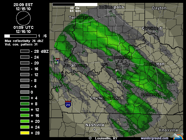
The bands of precipitation to the southwest of Louisville are filling in quite quickly and we'll see those come into the Metro area within the next hour or two. We're still on track for 1-2" of snow before 1am tonight, but a few of the short-range models are indicating a 2-4" accumulation in Louisville if these snow/sleet bands fill in and set up well. We'll see if that happens, but for right now all eyes are on the radar. The snow and sleet will eventually turn in to freezing rain sometime between 1am and 2am here in Louisville, but areas to our northeast across the Ohio River in Indiana will most likely stay all snow and sleet and see accumulations over six inches in some cases. Areas to the south and west of Louisville like Elizabethtown, Bowling Green, etc will have little snow and see mostly sleet and freezing rain tonight. The good news for them is that surface temperatures have a good shot at getting above freezing later on tomorrow, whereas here in Louisville and points north that probably won't be the case.

I'm getting lots of questions about schools being open tomorrow and right now I can't supply a definite answer. Locally in Louisville I think the side roads and streets will be dangerous tomorrow morning (4-10am), so that will probably be a strike against schools being open tomorrow. Road crews are hard at work on interstates and major roads, but we'll see how surface temperatures cooperate with that overnight. Areas to our north with the heavy snow will also see many cancellations. This is still very much a "wait and see" game right now, but it's not looking too good for us weather-wise at the moment.

Sunday, December 12, 2010

12/12 - 9pm - Snow is Making Things Hazardous in Louisville

Hazardous Roads
I just got back from a drive out on the Watterson Expressway, I-64, and the Gene Snyder. All of those interstates had snow on them, but they weren't quite covered. Needless to say, everyone is taking it slow and easy out there tonight. Most side roads and even some major streets have snow cover on them right now around Louisville, so take extra precautions if you're out driving tonight into tomorrow. With temperatures getting below 20 tonight in the city, the salt that Metro road crews have put down will not be as effective and major roadways could be difficult to drive on.

Snow Tonight
Louisville has been getting hit by multiple snow bands throughout the evening and it appears that at least a couple more developing in Indiana right now could hit us later on tonight. Most areas around the city and surrounding counties have seen an inch or two of snow with locally heavier amounts. These snow bands tonight could give us another inch or two in places, so a total snow accumulation of 2-3" in the city looks about right. Many area school systems are already announcing closures tomorrow and I'm inclined to think that schools around Louisville may have delays or closures based on the poor road conditions already present. (EDIT 9:23pm: Jefferson County Public and Catholic Schools have announced they will be closed tomorrow)

Gusty Winds
The winds are really going to pick up tonight on the backside of this storm. Winds just to our west in Paducah, KY and Southern Illinois are topping 25mph and those speeds are certainly headed our way. Winds tonight into tomorrow could get up to 35mph. That kind of wind will put wind chills down to zero and blow this dry, powdery snow around like dust. Visibilities will likely be reduced tonight and tomorrow, so keep an eye out if you're traveling.

Here's some irony for you... I have an appointment to get my wisdom teeth removed tomorrow morning. Not sure if that's still going to happen or not. If the surgeon's office is open tomorrow, I won't be posting on the blog or Facebook/Twitter for about a day or so while I'm recovering. If it's not, I'll have more updates tomorrow!

Friday, March 13, 2009

3/13 - 8:30pm - Warming Up Slowly

You may have seen the school closing/delay crawlers on the bottom of your local news channels this morning. Here's why:


(Click image to see a larger view)

Counties to our south received up to 3 inches of snow late last night, which caused problems for the morning commute in Larue, Hart, Nelson, and other counties in Kentucky. This will be one of the last (if not the last) accumulating snowfalls in the area for the season.

Warmer temperatures are on the way as high pressure builds back in. Tomorrow will see a high near 50 degrees due to showers developing around the area. Sunday will take things up a notch with a high in the mid 50's and rain moving out by the afternoon. We'll rise steadily through the 60's for Monday and Tuesday, with a high in the 70's for Wednesday.

Another cold front with rain comes through on Wednesday, so we'll have to bid the warm temperatures adieu once again. We won't drop as far in temperature as we did with the last cold front though, with highs only going down into the low 50's for the remainder of next week.

Sunday, February 1, 2009

2/1 - 5pm - JCPS CLOSED MONDAY

Jefferson County Public Schools will be closed on Monday. Classes should resume on Tuesday according to local media.

Wednesday, January 28, 2009

1/28 - 4pm - JCPS CLOSED REST OF THIS WEEK

Jefferson County Public Schools will be closed for the rest of this week according to media reports. As many as 67 schools are without power at the moment.

Tuesday, January 27, 2009

1/27 - 9pm - JCPS IS CLOSED TOMORROW

The announcement just came over the airwaves that JCPS is closed tomorrow. This comes just after their participation in an NWS Louisville conference call at 8pm.

Sunday, December 14, 2008

12/14 - 10pm - MIXED PRECIPITATION TOMORROW

After a couple model runs, I'm convinced we'll see sleet, freezing rain, and snow tomorrow afternoon and night. The GFS and NAM both backed off on this in their 18z runs, but the brand new 0z run of the NAM has brought a majority of the precipitation back. I'm awaiting word from the NWS in Louisville as to whether we'll have an advisory issued tomorrow or a full-blown Winter Storm Warning. Either way, I still think we're in for up to .25" of ice with up to an inch of snow on top by Tuesday morning.

As far as early dismissals for schools tomorrow, I think it'll be a close call. The NWS says it'll be below 32 after 5pm, but we could see an earlier drop in temperature if this cold front accelerates. That'll be interesting to watch over the next 12 hours. For Tuesday, If we do get up to .25" of ice, I'm expecting quite a few school cancellations and delays.

Friday, September 19, 2008

9/19 - 1pm - Warming Up a Bit

Mid 80's will stick around here for the weekend as the sunny and dry weather continues. A small system to our south will bring showers to downstate Kentucky, but no such luck for us. We really do need the rain. At least the weather is pristine for the Ryder Cup!

We're down to 98,000 customers without power from LG&E, which is still a huge number considering the winds rolled through on Sunday. JCPS will have school on Monday since only 14 schools lack power and generators can be used for them. The school year will be extended to June 1st to accommodate the missed days. With a possibly nasty winter on the way, it's doubtful that this will be the final time this year that the last day of school is moved.

Wednesday, September 17, 2008

9/17 - 4pm - We're Back in Business!

The power came back on at my house a couple hours ago much to my surprise. Since we live on the Jefferson/Spencer County border, we're usually the tail end last people to get power restored after a storm. Three days of "camping" inside my house is finally over and normal life resumes... unless you go to a JCPS school (which I do). JCPS is canceling for the rest of this week due to more than 40 schools without power. Things should return to normal by Monday and classes should resume.

That was some wind event. I can't even call it a storm because barely a drop of rain fell with it! Many are still puzzled as to why this happened, and here's why: Remnants from Hurricane Ike slid northwest of here on Sunday morning as a cold front intercepted it and made it increase in speed. As that was happening, a low level jet of around 70-90mph was making itself known a few thousand feet off the ground. Once the air started mixing from the ground into that jet, high wind gusts got to our altitude and wreaked havoc. That's it in a nutshell.

With not a drop of rain in the forecast for the next week, highs should stay in the lower 80's. Our next chance of rain could be as far away as next Tuesday... boy do we need it!

Thursday, February 21, 2008

2/21 - 4pm - Houston, We Have an Ice STORM!

I totally didn't expect JCPS to dismiss early today. Apparently the NWS held a press conference and told the school systems to either dismiss early or suffer the consequences. Kudos to the NWS!

We're not done yet even though the freezing rain is tapering off. Later tonight, if we are below freezing, the mother of all ice events will come through with a possibility of thunder too. It looks like we'll be below freezing until 4am the NWS says. If that's the case, we'll have more than a 1/2" of ice. That's a terrible mess folks. If we indeed stay below freezing that long, you can count on at least a 2 hour delay tomorrow for school systems around the area.

My street is a sheet of ice, but the interstates are fine. Looks like the metro road crews have pulled through once again! Too bad they can't do the neighborhood streets, but that would be way too much salt and money down the drain.

We'll see how the temperature holds...

Wednesday, February 20, 2008

2/20 - 9:30 - ICE STORM

Oh what to do, what to do... The GFS is calling for a pretty good lickin' of an ice storm, with temps really warm above a few thousand feet and temps cold at ground level. The NAM is similar, but its warmer aloft. The NWS is even floating the idea of issuing an ICE STORM WARNING instead of a winter weather advisory as well.

This will start tomorrow afternoon from 2-4pm as some snow and sleet. Rush hour tomorrow afternoon will be a mess for the most part. As night falls the temperatures aloft will rise and then we'll transition to freezing rain. That's worse than sleet since you get sheets of ice instead of manageable pellets. I think we could get a sizable accumulation of ice too, over .25" possibly. We should be all rain by Friday afternoon.

So, this isn't a snow event by any means. I think there might be a 2-hour delay or cancellation for JCPS on Friday if we do get ice accumulation. We'll see how that works out though...

Wednesday, February 13, 2008

2/13 - 5pm - Surprise Snow Showers

Before I get to the weather, I need to set the record straight on something first. Back roads and subdivisions were absolutely treacherous this morning. Main roads were dangerous due to visibility issues along with some slick spots. Adding insult to injury, we received about .5"-1" of snow during the rush hour commute this morning. Why on earth did JCPS only delay? Buses were wrecking left and right, getting stuck on hills, and causing more traffic problems on top of normal commuters at 9am. I got to school 15 minutes late this morning on my bus due to horrendous traffic on Breckenridge Lane and on Taylorsville Road. Come on JCPS, remember that you have thousands of kids that you can put into harm's way. The fact that they didn't close this morning is just appalling. Kudos to the counties around us that did close. They had the safety of their students in mind.

Sorry, just had to let that one out folks. They really blew it this morning.

We did get some surprise snow showers this morning after a chance of flurries was forecast. According to the NWS, seems an area of low clouds decided to just condense and drop on us all at once unexpectedly. It's still snowing right now, and temperatures are holding in the mid 20's. Interesting how long this storm is hanging around, especially after the surprise of getting it to begin with. We'll be in the upper 40's tomorrow though, so no more surprises.

The storm on Sunday is looking warmer than initially thought and the one on Friday has vaporized from the GFS. So don't be overly optimistic on snow yet. I think the GFS is playing games on the Sunday one though, so be ready for more possible surprises there.

Tuesday, February 12, 2008

2/12 - 9:10pm - Winter Weather ADVISORY

A Winter Weather ADVISORY has been issued for the whole area as temperatures drop below the freezing mark and sleet and freezing rain are starting to fall. I have freezing rain at my house right now with 30 degrees. The roads will become frozen overnight as the ponding on the roads solidifies. From what I've seen/heard, there is a back side to this storm that nobody really saw and it's giving us more freezing rain than expected. It's heavier in some places than others, but the NWS says we could get up to .05"/hr of freezing rain, which is pretty substantial by freezing rain standards. School districts are already throwing in the towel in Indiana, but we'll see what they do here. I think JCPS might get a 2 hour delay, but the temperature will be below freezing tomorrow for the whole day which would exacerbate conditions. If we get another quarter inch of ice on the ground, school could be canceled. It's been a long time since we've had 2 consecutive school closings, but hey it's happened. It's a real mess right now, and the NWS says this could go on for quite a while longer. Stay tuned.

Monday, February 11, 2008

2/11 - 10:30PM - JEFFERSON CO. PUBLIC SCHOOLS CLOSED

Just 10 mins ago on Fox41, Jefferson County Schools were reporting being closed tomorrow (Tuesday). YEEEEE HAWWWW!!!! I knew it! With 4.5" of snow they just had to!

2/11 - 10PM - 4 inches on the ground!

That's right, I have 4 inches on the ground at my house! I saw reports of 5 near downtown. We'll get at least another couple inches of snow tonight before we change over to sleet and freezing rain. I think Jefferson County will close tomorrow, it's just going to be a horrid commute. This might be my last post for the night, but if I'm still up at 11 I'll post then.

Monday, January 21, 2008

1/21 - 5:30pm - Snow ADVISORY

Yep, that's right! A SNOW ADVISORY has been issued for most of the counties around here, including Jefferson. We're still looking good for 1-2 inches by tomorrow morning and I think we'll still see some delays and cancellations for schools and businesses tomorrow. If we can get the heavier snow in here by 6-7am, I think we'll definitely see some of those. I've decided not to do a Winter Update video because I think the storm is too small to do a video for. If anything comes up, I'll post later.

Thursday, January 17, 2008

1/17 - 10pm - That was... Interesting

I'll be honest and say I was surprised that we had snow on the ground this morning. When I went to bed last night, I was a little worried about the temperature. But in the end we got our 1/2" and there were a few delays (but not JCPS of course).

We'll see more snow showers tomorrow night in colder air, so that might stick better. After that we'll see temps in the 20's this weekend. Brrr! Still working on a system for late next week, but right now that's a toss-up. Given our current luck, I'm not excited about this one at all. There's a warm-up coming in a couple weeks as well. We'll see how that goes...

Thursday, December 6, 2007

12/6 - 8pm - WINTER WEATHER ADVISORY

I thought this was something we wouldn't have to deal with tonight, but this low system has dropped south that is impacting the Midwest. Tonight we will see sleet, freezing rain and snow affect the area until mid-morning tomorrow when we should (in theory) see all precipitation turn to rain with mixed in flurries. Our low tonight will be at or just below freezing which will impact our weather for tomorrow. Downtown it's 34 right now and it's 29 out in the suburbs where I live.

If the temperature holds just below freezing we will see some major problems with the commute tomorrow morning. We'll have accumulated ice and snow (not exceeding 1 inch) on the roads in that scenario. If we stay above freezing, then it'll just be the bridges and overpasses that need watching. Personally, I think we'll see temps hold below freezing in the suburbs and right at freezing in the city. I cannot speculate on school delays for tomorrow morning, but I wouldn't be surprised if I saw some.

We've still got that 17th storm on the GFS! Remember: this is still 11 days away, do not get your hopes up.

Monday, February 5, 2007

This could be either nice or REALLY NICE!!!

Well, this little clipper thing has turned into a BIG clipper thing almost overnight. This morning, the NAM and GFS dropped it south, just as I thought it could. Folks, I won't kid you. We could see a potential 5-6" inches out of this IF it shifts a mere 25-50 miles south. I am estimating 2-4" inches though, out of a little skepticism and reality. This will occur at 2pm tomorrow and end at 8pm, prime for an early school cancellation. There are some models putting this thing through Louisville, including the famed GFS. I'll stick with the NAM though.

I want to urge you now (I hope I don't look like a doophus if this thing falls through), get needed supplies NOW. These systems are unpredictable on strength sometimes and like to pop out a really big storm. IF we end up with 5-6 inches of snow, this will certainly close school for a day or more and basically shut down the city for a couple days. This event won't be as bad as the Dec 2004 storm (10"), but nevertheless any snow in Louisville is a big deal.

I heard a report on WHAS 11 that JCPS people are working with meteorologists to determine an early dismissal tomorrow, which looks ominous at this time due to the 2pm beginning of the storm.

I will post later tonight and after school tomorrow as this develops. Hold in there, this could be big if things come together just right. I do want to urge that it won't be a record breaker, but it will surely be the biggest storm so far this season.

By the way, did you know that today is Weatherperson's day? I didn't know either until this morning...