As we make our way back to Oklahoma City on our last day of this week's storm chasing tour, I'm looking over quite a bit of data for next week's severe weather potential. After a lengthy period of high pressure ridging across the Plains (A.K.A. no storms) we're finally seeing signs that a large-scale trough will begin to move onshore from the Pacific and begin to affect the Plains during the middle part of the week. A smaller trough will be coming through this weekend as well but not a lot of moisture and our inability to chase during its peak on Saturday due to our down day in Oklahoma City means it will not be discussed here.
This trough coming in next week will need some moisture to work with for severe weather to form. This is something we've had a problem with for a while now but it looks like the Gulf of Mexico will finally be "open for business" starting next week. As the trough begins creating southwesterly winds and diffluence aloft in Kansas extending into Northwest Oklahoma on Wednesday (5/23), southerly winds at the surface should begin to bring in some much-needed moisture. The degree to which this will happen is still very much up in the air at this point because the GFS model has been consistently overshooting actual dew points, meaning it's been too optimistic about moisture return. The European model does agree that moisture will begin flowing into the Plains on Wednesday, but to a lesser degree than the GFS on the right.
This setup will continue right into Thursday and Friday as the trough digs in and moisture continues to flow into the region. These two days may harbor better severe weather chances than Wednesday due to having more time for moisture to return. Given the possibility that small-scale weather phenomena like cloud shields and overnight storms could limit potential on any of these days it's very difficult to point out which of them will be the best for storm chasing. Not only that, but the aforementioned computer model issues and amount of time between now and the trough moving into the Plains creates an even bigger margin of error. It's safe to say right now that things are certainly looking more favorable synoptically (on a large scale) for severe storms, but calling for a tornado "outbreak" at this point wouldn't be logical due to the variability of all the smaller features involved. This setup certainly has our attention and we're keeping close watch! Our robotic streaming webcam has been sitting dormant since we haven't had any storms lately, but we're hoping that we can put it in action next week.
It's a nice weekend across West Tennessee with warmer temperatures and breezy conditions. Another day of 80-degree weather is on the way for Sunday, but storms will roll through the region on Sunday night into Monday morning. Some of these storms could be a little strong, but they shouldn't be terribly severe, if at all, since they will be weakening as they approach the Mississippi River. Rain chances should subside completely after Tuesday and sunshine with highs in the 70's will be with us through the middle portion of the workweek. Check out my video from this morning below for more details!
A potent severe weather outbreak is just getting started in the Plains right now. Areas from Nebraska to Oklahoma are under a rare High Risk of severe weather from the Storm Prediction Center and violent tornadoes are expected this afternoon and evening. Already we've had quite a few reports of tornadoes touching down and doing damage in Kansas this afternoon, and more of the same can be expected as this system pulls more moisture northward and destabilization continues. On the left you'll see the latest EHI chart from the SPC, which is a measure of helicity (spinning motion in the atmosphere) and instability. This is a decent indicator of where the strongest tornadoes could form. It's really ramping up with values as high as 7 in Oklahoma right now, but those values are expected to increase and possibly move northward this afternoon and evening into Kansas and Nebraska.
Be sure and join me again on WBBJ for 7 Eyewitness News at 6 and 10pm tonight!
A potent severe weather setup looks likely this afternoon and evening for Tennessee, Kentucky, Alabama, Mississippi, and even parts of Indiana and Ohio. All the ingredients are coming together for what could be a sizable tornado outbreak in these areas, especially around Middle Tennessee and Central Kentucky, maybe extending into Indiana too. We've had severe weather in some of these places just earlier this week, but this setup looks to be even more potent than that. Cities like Louisville, Lexington, Cincinnati, Nashville, Bowling Green, KY, Huntsville, Jackson, TN, Tupelo, MS, Starkville, MS, and Birmingham need to be on the lookout today.
Risks and Timing
The Storm Prediction Center has outlined a Moderate Risk area for severe weather tomorrow in an expansive area of the South. This includes a 15% tornado risk. Storms will likely erupt early this morning as a warm front surges northward and bring a hail risk to West Tennessee while not-as-strong storms will affect the most of the remainder of Kentucky, Tennessee, and Mississippi. These storms shouldn't be a huge deal, but a few might reach severe limits.
A brief break in the action throughout the mid and late morning hours should provide enough recovery time for the atmosphere to recharge and re-fire storms around noon. These storms will try to get going in West Tennessee and Northeast Arkansas, but will gain strength as they hit areas of greater surface heating to the east. These are the storms that could be very bad in a lot of areas. The worst tornado threat throughout the afternoon will be in Central Kentucky and Middle Tennessee, but there's a secondary area that could have tornado problems in Northeast Mississippi into North Alabama if a little more low-level wind shear comes into play. The Storm Prediction Center's latest severe weather outlook seems to pick up on that secondary tornado risk area by extending the Moderate Risk down to East Mississippi and Alabama. Straight-line wind damage and hail will be possible throughout the South tomorrow, so even if you're not in an area where tornadoes will be likely you need to be on the lookout for severe storms. The storms should move out quickly tomorrow evening once the cold front accelerates southeastward through the region.
Details
The reason why Central Kentucky to Middle Tennessee will be the area for maximum tornado potential tomorrow is because of an alignment of a few factors. For one, the fastest upper-level winds will be centered right over this area tomorrow afternoon. When you couple that with almost southerly winds (may be a bit southwesterly at times), you get not only a high difference between wind speed aloft and at the surface, but also a difference in direction. This is called wind shear and it's crucial to sustaining a thunderstorm and allowing it to become strong enough for tornado development. The southerly winds at the surface will help what's called low-level wind shear, and that's usually a pretty big factor in who gets tornadoes.
These southerly winds will also be bringing in moist air from the Gulf, which is the fuel for these storms as they develop. While the best moisture will be over Mississippi, Alabama, and Tennessee tomorrow, it will still be ample for serious severe weather in Kentucky. This moisture will bring some serious atmospheric instability to the region. When you couple this instability with helicity (the tendency for the atmosphere to rotate), you get what's called the Energy Helicity Index (EHI). This is a decent indicator of where the best tornado ingredients will be, and as you can see on the left, the values are particularly high tomorrow across a pretty vast area from Mississippi through Kentucky. Supercells appear likely in Tennessee and Kentucky, but Northeast Mississippi may have more of a mixed supercell/squall line of storms scenario due to less wind shear. This could be an entirely linear squall line event across Northeast Mississippi/North Alabama tomorrow if wind shear under performs. While squall lines don't harbor as many strong tornadoes, it is still a very real threat that needs to be monitored.
Safety
Before severe weather
Make sure your cell phone is charged in case you lose power
Have flashlights with fresh batteries ready to go. Your cell phone should NOT be your primary flashlight
Your NOAA Weather Radio/Cell phone alert app should be ready to alert you
Make a central meeting location for family members should you lose communications after the severe weather passes
I've said before that I like iMapWeather Radio on the iPhone for weather alerts. This is not any sort of endorsement, but it is an app that I use and it just works.
When a Tornado Warning is issued for your area
Get to the lowest level of your home, apartment, or office
Stay away from windows and try to get to the center of the structure you're in
Evacuate mobile homes and get to a safe, sturdy building immediately
Make sure you are wearing sturdy shoes
If you have time (have these ready to go before a warning is issued), put bicycle helmets on the kids and yourself. Quite a few deaths were caused by head trauma in last year's tornadoes.
Please heed ALL warnings. This is a dangerous severe weather setup that needs no playing around with.
After a brief period of bitterly cold temperatures earlier this week, most of the eastern half of the nation is beginning to recover. Highs in Louisville today will get into the 50's and West Tennessee could reach 60 in places. This is all thanks to southerly airflow under a ridge that's developing to the west. Temperatures will remain reasonably warm with a few small dips this weekend.The big story is what will happen during the middle of next week. The NAO (North Atlantic Oscillation) and AO (Arctic Oscillation) are forecast to go at least neutral or negative during this time, which means that the pattern will be ready to support an outbreak of cold air in the East. The computer models have had a very difficult time lately resolving when exactly these oscillations will go negative, but it seems like there's enough of a consensus now to say that this will probably happen. How long they will stay negative remains to be seen, but given the time of year we're in now I would expect the cold air to stick around for a while.
The next issue with this cold air is the possibility of snow. A storm moving through on Wednesday could produce a rain to snow situation for Kentucky and Tennessee on Wednesday night if the cold air moves in quick enough. This is certainly something to watch since the models are not picking up on this well at this time. What they are picking up on is the bitter cold in the wake of this system as a trough sits on top of the East US. If you didn't get the super-heavy jackets out this week, you'll definitely need them by the end of next week!
I'm heading back to Mississippi State for the spring semester, so my broadcasts at WBBJ will resume next weekend. See you then!
Both yesterday and today I attended and volunteered at the 36th Annual National Weather Association Meeting in Birmingham, Alabama. This was the most-attended NWA meeting in history and evidence of that was clear this morning when there were no more seats for attendees! The volunteer portion of my attendance had me taking video of research posters from students and professionals for the agenda on the NWA website. While the meeting runs until Thursday, I had to leave late this afternoon to attend to class-related things back in Starkville. I wish I could've stayed longer because this was one of the best put together functions I've ever attended.
Speaking of attendance, I was able to meet quite a few experienced broadcast meteorologists while I was there. Some of those folks were Jim Cantore (The Weather Channel), Jacqui Jeras (CNN), Christie Dutton (WAVE-TV Louisville), Ryan Vaughan (KAIT-TV Jonesboro), Mary Wasson (YNN Austin), and Dave Freeman (KSNW Wichita). It was also great to see some old friends whom I've met before in Starkville at the Mississippi State Severe Storms Symposium.
The sessions that took place while I was there mostly focused on the historic tornadoes from this past year, and some of these spurred some really great discussion on how we as broadcast and operational meteorology professionals can improve our methods to save lives in severe weather. One of the things that strikes me from multiple presentations is the public's low use of NOAA weather radios. While these are lifesaving devices, it's clear that these things are very difficult to operate if you're not familiar with consumer electronic devices or don't understand how SAME codes work. This is a huge problem because people then depend on less reliable means of receiving warnings like tornado sirens. As I tweeted earlier today, Dave Freeman suggested that weather radios should use ZIP codes instead of SAME codes to separate out warnings. This would be much easier because just about everyone knows their ZIP code, but almost nobody (including me!) knows their county SAME code without consulting the NWS website. It's true that this wouldn't be an easy solution since either the radios or warning system would have to be able to identify ZIP codes based on coordinate polygons and because some ZIP codes are way too big. In the long run though, these would be relatively minor changes to a system that's had years of development behind it.
There's also been talk from a lot of people suggesting the placement of GPS chips in weather radios to determine exact location so that there's even less of a chance of the radio going off for a warning that does not pertain to the user. This is also a great idea that wouldn't require terribly huge changes to radios and how warnings are issued. Overall, I gathered from today's and yesterday's presentations that more needs to be done to make severe weather warnings more accessible and understandable to the public to save lives in events like April 27th. The technology is there and the ideas are in place, and the recent tornadoes that claimed so many lives this year are proof that these changes are necessary.
The city of Louisville is recovering from an outbreak of tornadoes that even the most seasoned weather watchers didn't expect. As of this writing there have been four confirmed tornadoes (two EF-1's and two EF-2's) inside the Jefferson County/Louisville city limit. A fifth tornado in Harrison County, IN has been confirmed of EF-0 strength that started off the event. The iconic Churchill Downs received damage to barns, several power poles near the University of Louisville's Papa John's Cardinal Stadium were brought down, and buildings in Jeffersontown sustained damage along with massive tree damage as a result of three of the four tornado touchdowns in the county. Thankfully there were no reports of injuries or fatalities as these tornadoes ripped through a city containing three quarters of a million people.
Below is a rough map I've put together based on the NWS WFO Louisville storm survey page of the tornado tracks through Louisville . Purple tracks indicate EF-2 rated tornadoes (the indicated tornadoes only reached this strength briefly) and the red tracks indicate EF-1 rated tornadoes. Be sure to click the image for a larger view.
Timeline of Tornadoes
Information used in this section about each tornado can be found on NWS WFO Louisville's storm survey page.
Yesterday started off cloudy and even misting at times across the city as a cloud shield from overnight persisted well into the morning hours. The Storm Prediction Center had a Slight Risk for severe weather out for a good portion of the Mississippi and Ohio Valleys northward to Michigan, but this was a very conditional risk for Kentucky and Indiana because the cloud cover in the morning inhibited destabilization of the atmosphere. A cold front sagging southeastward from Indiana would be the trigger for any afternoon storms should they form as temperatures warmed. The clouds finally moved east of the Louisville area at around 2:30pm yesterday and temperatures topped 80 degrees by 3pm. By 6pm there were showers on the radar to the north of Louisville and a few specks on the radar to the west.
Just after 7:30pm a Tornado Warning was issued for Harrison County, IN and western portions of Jefferson County/Louisville because a tornado was spotted near Elizabeth, IN. The "storm" that triggered this warning was no more than a shower because it had no lightning strikes associated with it. I'll admit that I was skeptical of this tornado report because there was really no significant rotation on radar. I thought the report was an improper identification of moving scud clouds or even a gustnado. The storm seemed to weaken and spotters near the Shively area reported no funnel clouds, so the warning was allowed to expire. About ten minutes later the storm began to strengthen again in West Louisville and another Tornado Warning was issued just after 8pm for Jefferson County. Multiple reports of a tornado and associated damage began coming in from Churchill Downs around that time. This time the storm had lightning and the visual tornadic hook echo with prominent rotation on radar, so it was clear at this point that this thing meant business. To the right is a radar image with the supercell and hook echo near Churchill Downs and below is the velocity data with the green/red couplet signifying where the rotation was at the time. Click either image to see a larger view:
This tornado strengthened briefly into an EF-2 with 120 mph winds near the intersection of Floyd and Central Avenue at the University of Louisville campus where the power poles came down. Here's a video from YouTube user kehdsh that was posted on the WAVE 3 Weather Facebook page this afternoon. It's a little far away, but it clearly shows the funnel cloud above and debris cloud on the ground near Churchill Downs. Note that a tornado does not need to have a visible funnel snaking all the way to the ground. The debris dust-up and tube near the ground verifies that a tornado is there. Watch the center of this video closely:
The next three tornadoes to hit Louisville were actually from the same storm and you could argue that it was the same tornado that lifted and touched down three separate times. From 9:29pm to 9:41pm (a total of twelve minutes with two short breaks in between) these tornadoes pestered the Louisville incorporated city of Jeffersontown, the suburb of over 26,000 people in Jefferson
Tree on dentist office in Jeffersontown
Image: Ryan Hoke
County that I've lived on the southeastern fringe of for nearly ten years. The initial touchdown occurred in the neighborhood just behind (west of) the Meijer store on South Hurstbourne Parkway west of Jeffersontown. This is just due south of the Stonybrook Cinemas. The tornado continued eastward to downtown Jeffersontown and lifted at the St. Edward School and Church, causing EF-1 (95-100 mph winds) damage along the path. It dropped again just east of the school and went on to cause tree damage at Tully Elementary School and structural damage at an apartment complex and the Good Samaritan Center in downtown Jeffersontown. The Good Samaritan Center had EF-2 winds of 115 mph that tossed and flipped cars about 20 yards. The tornado then went on to cause significant damage at the industrial park just east of Jeffersontown before lifting again. It sat down again in the industrial park causing more warehouse damage and continued on toward the Gene Snyder Freeway (I-265) where it lifted just after damaging a bed and breakfast on Tucker Station Road. This storm wasn't as well-defined on radar as the Churchill Downs supercell because of the merger of multiple storms in the county. The embedded supercell structure with rotation was certainly there as you'll see with the red/green boundary of wind velocities north of the Jeffersontown dot in the image below:
Why it Happened
Caution: This section gets a little technical on the meteorology side of things. I explain why I think tornadoes hit Louisville unexpectedly and in such a small area.
Nobody expected this rash of tornadoes in Louisville at all. This includes the National Weather Service, local media, and me. In my blog post yesterday morning I even stated: "The tornado risk for [Southern Indiana, Kentucky, and Tennessee] will be quite low." The Storm Prediction Center issued a Slight Risk with a 2% tornado risk area in the morning with mention of wind-driven linear storms possible across the Lower Ohio Valley. Later on in the day they issued a Mesoscale Discussion that indicated they may issue a Severe Thunderstorm Watch for a broad area from Cincinnati to Memphis if storms developed more, but they never did. Some folks are asking why they didn't issued a Tornado Watch as soon as the storms unexpectedly began producing a spotter-confirmed tornado in Central Louisville, especially when the tornado threat dragged on for roughly an additional two and a half hours. My guess is that the very small lead time they would give with the issued watch and the unknown end time for this already unexpected tornado outbreak led them to scrub any plans of issuing one. Not to mention that the watch would be extremely small given that tornadoes occurred across two counties. The National Weather Service office in Louisville did a very good job of handling all the reports and translating that information into warnings for folks in the path of these storms.
These storms formed in a highly speed-sheared environment meaning winds were very fast aloft, but much slower at the surface. The direction of the winds at the surface were forecast to be from the southwest according to most of the computer forecast models. Aloft at 18,000 ft the winds were forecast to be from about the same direction, but slightly more west. This means that there was little directional shear forecast, meaning the chances of storms rotating were slim. The setup was more favorable for damaging straight-line winds. Here's where things get interesting. At 2:43pm, surface observations showed southwest winds in Louisville as forecast. All is well, but watch that southerly wind vector (down-pointing flag) east of Evansville, IN in the top picture on the left. Just before 5pm this southerly surface wind vector is in Louisville as a south-southeast wind. This increased directional shear between the surface and 18,000 ft quite a bit. The timing also lines up with the development of small showers just to our west and north. The surface winds were from the south in Jefferson County between 5pm and just before 10pm. In between these times we had the tornado pandemonium in Louisville. The timing and location is just too perfect for these southerly winds to not be a contributing factor to this event. Low-level wind shear (the kind that produces tornadoes) would have been much higher in Jefferson County than the surrounding area with the surface wind out of the south given the winds aloft being from the southwest.
It's also interesting to note that the bulk shear output on SPC's mesoscale analysis had a 50 kt maximum right over Central Kentucky and Southern Indiana. I make no claim of being a research meteorologist, but this surface wind reasoning comes from my four years of chasing storms in the Plains and the experience I've gained from books on severe weather.
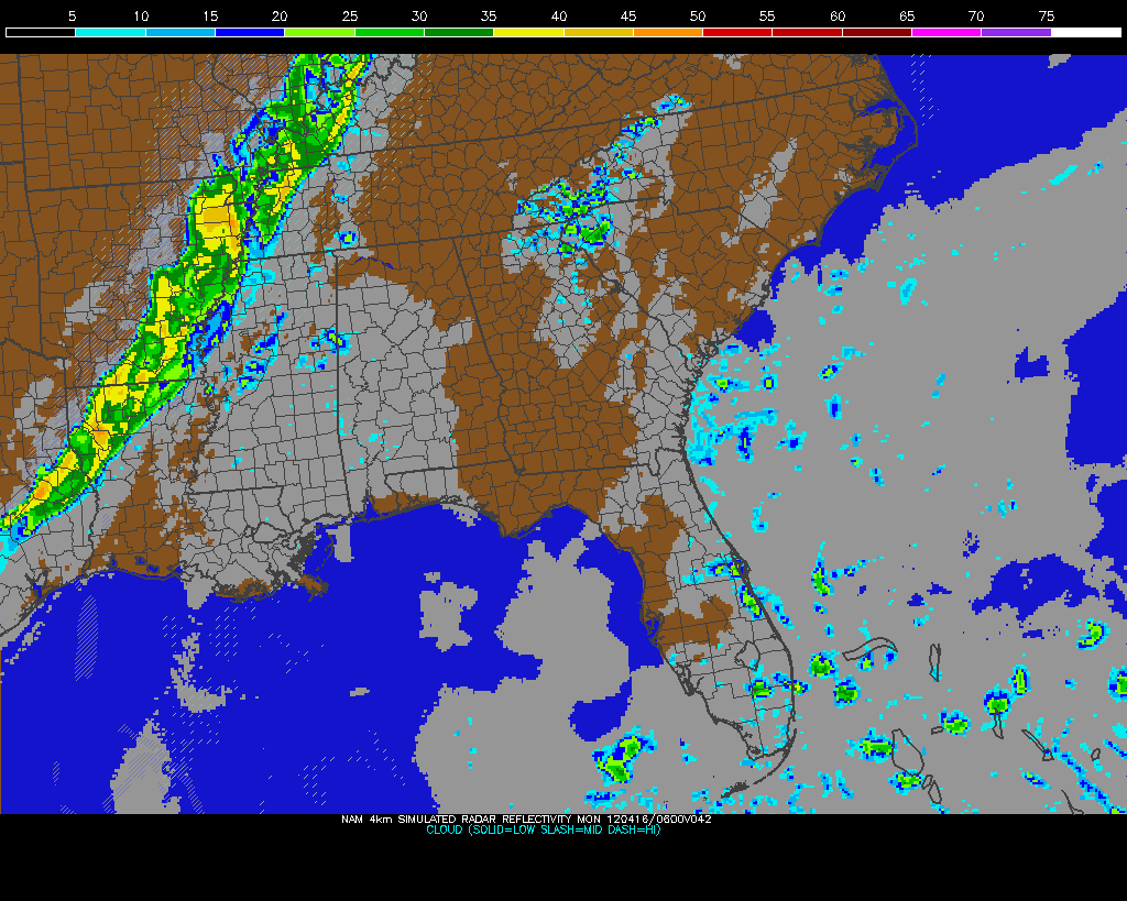
The RUC and NAM models yesterday morning did pick up on the fact that storms would indeed form in the afternoon near Louisville after the clouds cleared. The 12z RUC yesterday in particular seemed to pick out the linear nature of the storms that were to form less than twelve hours later. It was nowhere near perfect, but the timing and shape of the storms were in the ballpark. Check out the comparison of a live radar capture late last night and the aforementioned RUC reflectivity (simulated radar) output:
Finally, I wanted to point out that this all happened with less than 1500 J/kg of CAPE or instability. Usually you need a little more instability than that to get severe storms going, but I think the directional wind shear compensated for that. None of the other storms outside of the localized southerly winds around Louisville were severe. That plus the fact that we had a tornado touch down in Harrison County, IN (just west of Louisville) with little to no lightning present in the storm makes this a once-in-a-lifetime event that could have been much worse if people did not heed warnings. I'm extremely pleased that there were no reports of injuries or fatalities with these five tornadoes yesterday. Hopefully this event will be the last major population center to be hit by a tornado this year, which has seen tornadoes hit cities including Tuscaloosa, Birmingham, Joplin, MO, Oklahoma City, Springfield, MA, and now Louisville, KY.
Check out NWS WFO Louisville's storm survey page for more information on this tornado event.
After a very active day of chasing, we're heading to Eastern Colorado to prepare for tomorrow's risk of upslope storms in that area. Yesterday we drove 362 miles across Oklahoma while chasing and you can see a couple pictures and some video that I shot in the post below.
A HIGH Risk of severe weather has been issued by the SPC for West Tennesee, Western Kentucky, Southeast Missouri, Southern Illinois, Southwest Indiana, and Northwest Arkansas. Just a quick look at some data this morning reveals high dew points and winds backing to the south across the region. The satellite picture is also clear for most of Kentucky and Tennessee, so instability is building quite a bit already this morning. Cities like Jackson and Memphis in Tennessee, Paducah, Owensboro, and Louisville in Kentucky, Jonesboro, Arkansas, St. Louis, Missouri, and Evansville, Indiana need to be on high alert for a possible tornado threat this evening.
Rain-wrapped tornado near Piedmont and El Reno, OK
A tornado outbreak unfolded as forecast in Oklahoma yesterday, but unfortunately many of the tornadoes were shrouded in rain as these storms were overly laden with moisture. This not only made them nearly impossible to see, but also very dangerous to chase. We were right in front of but couldn't see the tornado that destroyed parts of El Reno, OK and in fact chased that cell from it's formation in Eakly, OK earlier in the afternoon. I'd venture to say that we were less than two miles from that violent tornado, but all that we could see was a giant grey mess in the distance.
Supercell forming near Eakly, Oklahoma
Later on after a trip through Oklahoma City, we took shelter in Moore, OK because of hail and a tornado passing over I-35 just in front of us as we went southbound. What we didn't know was that the twister took a northward jog and caused damage just a few hundred yards in front of us. Scary, no? It wasn't a strong tornado, but it toppled some power lines and threw some small debris into the interstate roadway. After that tornado passed by we went to survey some damage in Moore and Newcastle since the storms were quickly evolving into a linear system and moving into the heavy vegetation east of Oklahoma City. Check out the video below for all the action from yesterday:
Yet another tornado outbreak is on the way in the United States today and this time we're going to be smack-dab in the middle of it. A strong cut-off area of low pressure moving across the Plains this afternoon will provide the needed moisture-laden surface winds from the southeast and dry, pushing air from the southwest to create a sharp dry line that will be the focus for storm development this afternoon. Instability values will be off the charts as the cap (thunderstorm-inhibiting layer of warm air above the surface) breaks sometime during the middle of the afternoon. Temperatures aloft today will be slightly warmer than yesterday, so storms should stay isolated, especially south of the Kansas border. Locations near that border will most likely see a similar situation to yesterday, when tons of developing storms merged into an un-chaseable complex. There's a bit of a cloud shield situated vertically across the central part of the state this morning, but it should clear out fairly quick.
The Storm Prediction Center has issued a rare HIGH Risk for Oklahoma and Southern Kansas because of how potent this setup looks. The issuance of a HIGH Risk may not seem rare because of all the destructive outbreaks that have happened this year, but overall they don't issue one but once or twice at the most in a normal season. The risk includes a 45% tornado risk (!), something that has only been used for the devastating April 27th tornado outbreak in the South this year. Needless to say, expectations are high and a lot of folks are nervous around here. We're getting in position right now in Oklahoma and making adjustments as necessary based on conditions.
With such a huge outbreak expected, today is certainly the day that you need to follow me on Facebook and Twitter for my latest chase updates and photos if you haven't already.
The US just can't catch a break from horrendous tornado destruction this year. Last night a very powerful wedge tornado tore through the town on Joplin, Missouri leaving nearly 40% of the town destroyed and 89 dead as of this writing. Many are calling this tornado, which also ripped through a hospital in Joplin, an EF4 tornado. While no official designation will be given to this twister until the National Weather Service completes a survey of the damage, the look of the destruction on TV and online suggests an EF4-like tornado. The pictures coming in look just like Tuscaloosa, which was hit by a similar tornado on April 27th. We were not in Joplin last night because it was too far away from our starting location in Amarillo where we picked up our new tour guests. We also usually don't chase in that area because of the increased vegetation and topography issues. (AP Photo/Charlie Riedel)
This morning we're in Oklahoma getting into position for what could be another active day. The Storm Prediction Center has issued a Moderate Risk for severe weather across much of Oklahoma and unfortunately the hard-hit Joplin area in Missouri. A 10% tornado risk accompanies this severe weather outlook, which you'll find below. Dew points in the upper 60's to near 70 will be more than enough for storm development this afternoon and east surface winds coupled with southwest winds aloft should enhance wind shear. The surface area of low pressure we're watching along the Oklahoma/Kansas border may be dropping south and west this afternoon, so we'll have to follow the good surface winds as they move.
Don't forget that you can follow me on Twitter and Facebook for the latest updates as we're chasing!
Absolute hell. That's about the only way to describe last week's historic severe weather outbreak in the South. It started on Monday the 25th in Texas and Arkansas as a fairly significant rash of tornadoes and slowly spread eastward on the 26th with an increased amount of tornado reports over a larger area. As the system made its way into the untapped unstable air of Mississippi and Alabama on the 27th, dozens of supercell thunderstorms exploded into existence on a scale that hasn't been seen since the Super Outbreak of 1974. The Storm Prediction Center issued a HIGH Risk for severe weather for much of Alabama and Mississippi. Numerous PDS (Particularly Dangerous Situation) Tornado Watches were in place. Since the National Weather Service and media had exhausted just about every option to inform the public of the impending tornado outbreak, all that was left to do was to hope that it wouldn't turn out to be as bad as feared.
Around 2:45am CDT: My NOAA weather radio jolts me out of bed as a Tornado Warning is issued for Oktibbeha County, Mississippi, which is where Mississippi State University is located. The ugly bow echo/embedded supercell structure line of storms that crossed the Mississippi River just as I went to bed for the night held its strength well into the early morning hours as it passed through Northeast Mississippi. The rotation in a cell near the MSU campus appeared to be passing just to the south after watching the radar for a few minutes, so I was ready to head back to bed (had a differential equations final exam scheduled for 8am). That's when a cell to the north of Starkville caught my eye. The rotation as indicated by the base velocity input on this cell was extremely strong. I felt it was very odd to see rotation this pronounced in a storm that was embedded in a mess of other storms this late at night, but this was no run-of-the-mill outbreak. This is what I saw (Thanks NWS JAN for posting these):
It was a forgone conclusion that this storm was putting down a tornado based on the radar and reports coming in. To the bottom right of the storm is Starkville, so Mississippi State was within a short drive of this tornado. One fatality and 20 injuries occurred before the tornado lifted in Clay County. It was rated an EF-3 with 140mph winds after a storm survey.
After my final exam, I packed my entire dorm room into my car and checked out so I could head back home to Louisville for the summer. The early morning storms were long gone to the east by that point, but a slew of supercells were already forming in the afternoon heating of the day and dry
line push near the Mississippi River. I raced northward on US 45 trying to beat a majority of the storms before they cut off my route into Tennessee. One of these supercells would go on to produce the first EF-5 tornado in Mississippi since 1966. This tornado hit Smithville, MS head-on and caused 14 fatalities with 40 injures in Monroe County before 4pm CDT. Here's a panoramic photo taken by Mississippi State University's Director of Broadcast Meteorology Renny Vandewege of the Smithville damage:
I realized rather quickly that my good fortune was going to run out north of Tupelo, MS, but I kept traveling north in hopes of possibly catching up with the updraft base of a supercell that was going to cross the road right in front of me. This cell had definite rotation in it and reports of grapefruit-sized hail were coming across the wires, so I knew I had to calculate my position delicately. An image of my position (blue cross-hairs) compared to the velocity couplet on radar is below:
I was within a mile of the updraft base when the rain and hail from a cell just to the south and west of the one I wanted to intercept began overspreading my route. It looked like I was heading into a giant black wall of cloud and precipitation, almost cave-like in the way that it extended from the sky to the ground. Wind gusts of over 40mph began to hit my car and that's when I knew to turn around and head toward Baldwyn, MS to avoid damage to my vehicle. Visibility was horrible because of the rain being thrown into the path of my storm by the other, so I would have not been able to see a tornado until it was too late had I continued on. After waiting a few minutes near Baldwyn, it was was safe to drive north again due to a gap that had formed between storms on US 45. The rest of my drive to Louisville was uneventful due to calmer weather in West Tennessee and Kentucky.
On the way home I listened to the audio of Birmingham's ABC 33/40 severe weather stream. Hearing James Spann's coverage of the Tuscaloosa/Birmingham wedge tornado and seeing the images after the fact was heartbreaking. It is nearly impossible to not have mass fatalities from a wedge tornado that hits two major cities head-on, especially when most residents do not have basements. The visibility of the tornado may have saved many lives that Wednesday because TV stations, including ABC 33/40, were able to show viewers live pictures from their outdoor sky cameras of the tornado wreaking havoc on the cities:
Multiple-vortex wedge tornado hitting Tuscaloosa from ABC 33/40's Sky Cam
These pictures made much more impact on the residents of the area than a radar image, so the motivation to take cover from this storm was far greater than usual. The path of this storm took it from Kemper County, MS to western North Carolina, lasting over seven hours. This tornado has been rated at least an EF-3, but ongoing damage surveys could increase this preliminary rating.
The 342 confirmed deaths from this outbreak has already eclipsed the Super Outbreak of 1974, and this number is sure to rise with the number of people still missing. Sorting out the actual number of tornadoes remains a tedious task for multiple NWS offices, but so far 121 have been confirmed from the 25th to the 28th. Up until last week most severe weather outbreaks were compared to the Super Outbreak of 1974. From now on, the Super Outbreak of 2011 will be an additional basis for comparison.
175 tornadoes were reported on April 27th. Many of those reports are duplicates.
If you would like to help the thousands of residents in Mississippi, Alabama, Georgia, Arkansas and more affected by this outbreak, please consider donating to the American Red Cross by clicking the link on the right-hand column of this blog.
A potential tornado outbreak is poised to affect Mississippi, Alabama, and Tennessee tomorrow as a rather potent low and associated trough swing through the central part of the nation. Once a warm front passes through the region tomorrow morning and moisture from the south begins to filter in, all forms of severe weather will be possible in North Mississippi, North Alabama, and West Tennessee. I want to place a particular emphasis on Northeast Mississippi and Northwest Alabama, where the greatest risk of tornadoes appears to be at this time. Large hail and damaging winds are possible across the entire region. The Storm Prediction Center has placed these areas under a 45% Moderate Risk of severe weather for tomorrow.
Keep up with my weather updates on my Twitter and Facebook page.
Timing
Timing is going to be difficult to pin down tomorrow as some computer models have slowed down the overall movement of the system. Areas near the Delta in Mississippi could see severe weather late tonight, but the remainder of the state shouldn't see any until the morning and afternoon hours. Here in Starkville it'll most likely be after 11am when we begin to see supercells pop up on the radar and the risk for severe weather could extend well into the early evening hours. West Tennessee will likely see the risk for severe weather develop after noon and extend to just after sunset. NWS Jackson's timeline on the left is a pretty good guess at when things will develop and where tomorrow.
Details
The SPC's Moderate Risk verifies quite well on the computer model forecasts. Ahead of a surface low in Missouri tomorrow, surface winds will become southeasterly in East Mississippi and West Alabama while upper-level winds (500mb) will be quite strong out of the southwest. This will cause quite a bit of directional and speed shear from the lower levels to the upper levels of the atmosphere that will aid in the creation of rotating supercell thunderstorms. These individual cells will most definitely carry a tornado risk as they develop and roll through tomorrow after the noon hour. Dew points in the mid to upper 60's will aid in the creation of these storms and send instability (CAPE) values well over 1500 J/kg in places.
The SREF model's Significant Tornado Parameter will be at a 4 for most of Mississippi tomorrow, but again the ingredients for tornado creation will most likely be at their prime in the eastern half of the state in the afternoon. West Tennessee won't be at quite the high level of risk that Northeast Mississippi/Northwest Alabama will be in tomorrow due to a lessening of moisture and instability as you head northward, but tornadoes, wind, and large hail are still in play tomorrow afternoon.
I will be driving from Starkville to Jackson, TN tomorrow afternoon in preparation for my Saturday morning show at WBBJ-TV. I am going to try and time my departure so that I can possibly intercept a supercell from its southern side as I drive northward. Storm motions of over 40 mph and the poor road network in Northeast Mississippi aren't good for storm chasing, so that's off the table unless something extraordinary happens.


 A potent severe weather outbreak is just getting started in the Plains right now. Areas from Nebraska to Oklahoma are under a rare High Risk of severe weather from the Storm Prediction Center and violent tornadoes are expected this afternoon and evening. Already we've had quite a few reports of tornadoes touching down and doing damage in Kansas this afternoon, and more of the same can be expected as this system pulls more moisture northward and destabilization continues. On the left you'll see the latest EHI chart from the SPC, which is a measure of helicity (spinning motion in the atmosphere) and instability. This is a decent indicator of where the strongest tornadoes could form. It's really ramping up with values as high as 7 in Oklahoma right now, but those values are expected to increase and possibly move northward this afternoon and evening into Kansas and Nebraska.
 The Storm Prediction Center has outlined a Moderate Risk area for severe weather tomorrow in an expansive area of the South. This includes a 15% tornado risk. Storms will likely erupt early this morning as a warm front surges northward and bring a hail risk to West Tennessee while not-as-strong storms will affect the most of the remainder of Kentucky, Tennessee, and Mississippi. These storms shouldn't be a huge deal, but a few might reach severe limits.
 The reason why Central Kentucky to Middle Tennessee will be the area for maximum tornado potential tomorrow is because of an alignment of a few factors. For one, the fastest upper-level winds will be centered right over this area tomorrow afternoon. When you couple that with almost southerly winds (may be a bit southwesterly at times), you get not only a high difference between wind speed aloft and at the surface, but also a difference in direction. This is called wind shear and it's crucial to sustaining a thunderstorm and allowing it to become strong enough for tornado development. The southerly winds at the surface will help what's called low-level wind shear, and that's usually a pretty big factor in who gets tornadoes.
 These southerly winds will also be bringing in moist air from the Gulf, which is the fuel for these storms as they develop. While the best moisture will be over Mississippi, Alabama, and Tennessee tomorrow, it will still be ample for serious severe weather in Kentucky. This moisture will bring some serious atmospheric instability to the region. When you couple this instability with helicity (the tendency for the atmosphere to rotate), you get what's called the Energy Helicity Index (EHI). This is a decent indicator of where the best tornado ingredients will be, and as you can see on the left, the values are particularly high tomorrow across a pretty vast area from Mississippi through Kentucky. Supercells appear likely in Tennessee and Kentucky, but Northeast Mississippi may have more of a mixed supercell/squall line of storms scenario due to less wind shear. This could be an entirely linear squall line event across Northeast Mississippi/North Alabama tomorrow if wind shear under performs. While squall lines don't harbor as many strong tornadoes, it is still a very real threat that needs to be monitored.

 Both yesterday and today I attended and volunteered at the 36th Annual National Weather Association Meeting in Birmingham, Alabama. This was the most-attended NWA meeting in history and evidence of that was clear this morning when there were no more seats for attendees! The volunteer portion of my attendance had me taking video of research posters from students and professionals for the agenda on the NWA website. While the meeting runs until Thursday, I had to leave late this afternoon to attend to class-related things back in Starkville. I wish I could've stayed longer because this was one of the best put together functions I've ever attended.
 Speaking of attendance, I was able to meet quite a few experienced broadcast meteorologists while I was there. Some of those folks were Jim Cantore (The Weather Channel), Jacqui Jeras (CNN), Christie Dutton (WAVE-TV Louisville), Ryan Vaughan (KAIT-TV Jonesboro), Mary Wasson (YNN Austin), and Dave Freeman (KSNW Wichita). It was also great to see some old friends whom I've met before in Starkville at the Mississippi State Severe Storms Symposium.
 There's also been talk from a lot of people suggesting the placement of GPS chips in weather radios to determine exact location so that there's even less of a chance of the radio going off for a warning that does not pertain to the user. This is also a great idea that wouldn't require terribly huge changes to radios and how warnings are issued. Overall, I gathered from today's and yesterday's presentations that more needs to be done to make severe weather warnings more accessible and understandable to the public to save lives in events like April 27th. The technology is there and the ideas are in place, and the recent tornadoes that claimed so many lives this year are proof that these changes are necessary.


 This time the storm had lightning and the visual tornadic hook echo with prominent rotation on radar, so it was clear at this point that this thing meant business. To the right is a radar image with the supercell and hook echo near Churchill Downs and below is the velocity data with the green/red couplet signifying where the rotation was at the time. Click either image to see a larger view:


 where it lifted just after damaging a bed and breakfast on Tucker Station Road. This storm wasn't as well-defined on radar as the Churchill Downs supercell because of the merger of multiple storms in the county. The embedded supercell structure with rotation was certainly there as you'll see with the red/green boundary of wind velocities north of the Jeffersontown dot in the image below:

 Nobody expected this rash of tornadoes in Louisville at all. This includes the National Weather Service, local media, and me. In my blog post yesterday morning I even stated: "The tornado risk for [Southern Indiana, Kentucky, and Tennessee] will be quite low." The Storm Prediction Center issued a Slight Risk with a 2% tornado risk area in the morning with mention of wind-driven linear storms possible across the Lower Ohio Valley. Later on in the day they issued a Mesoscale Discussion that indicated they may issue a Severe Thunderstorm Watch for a broad area from Cincinnati to Memphis if storms developed more, but they never did. Some folks are asking why they didn't issued a Tornado Watch as soon as the storms unexpectedly began producing a spotter-confirmed tornado in Central Louisville, especially when the tornado threat dragged on for roughly an additional two and a half hours. My guess is that the very small lead time they would give with the issued watch and the unknown end time for this already unexpected tornado outbreak led them to scrub any plans of issuing one. Not to mention that the watch would be extremely small given that tornadoes occurred across two counties. The National Weather Service office in Louisville did a very good job of handling all the reports and translating that information into warnings for folks in the path of these storms.

 These storms formed in a highly speed-sheared environment meaning winds were very fast aloft, but much slower at the surface. The direction of the winds at the surface were forecast to be from the southwest according to most of the computer forecast models. Aloft at 18,000 ft the winds were forecast to be from about the same direction, but slightly more west. This means that there was little directional shear forecast, meaning the chances of storms rotating were slim. The setup was more favorable for damaging straight-line winds. Here's where things get interesting. At 2:43pm, surface observations showed southwest winds in Louisville as forecast. All is well, but watch that southerly wind vector (down-pointing flag) east of Evansville, IN in the top picture on the left. Just before 5pm this southerly surface wind vector is in Louisville as a south-southeast wind. This increased directional shear between the surface and 18,000 ft quite a bit. The timing also lines up with the development of small showers just to our west and north. The surface winds were from the south in Jefferson County between 5pm and just before 10pm. In between these times we had the tornado pandemonium in Louisville. The timing and location is just too perfect for these southerly winds to not be a contributing factor to this event. Low-level wind shear (the kind that produces tornadoes) would have been much higher in Jefferson County than the surrounding area with the surface wind out of the south given the winds aloft being from the southwest.


 A potential tornado outbreak is poised to affect Mississippi, Alabama, and Tennessee tomorrow as a rather potent low and associated trough swing through the central part of the nation. Once a warm front passes through the region tomorrow morning and moisture from the south begins to filter in, all forms of severe weather will be possible in North Mississippi, North Alabama, and West Tennessee. I want to place a particular emphasis on Northeast Mississippi and Northwest Alabama, where the greatest risk of tornadoes appears to be at this time. Large hail and damaging winds are possible across the entire region. The Storm Prediction Center has placed these areas under a 45% Moderate Risk of severe weather for tomorrow.

