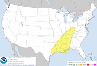
Heavy rain and storms are going to be sticking around the Southeast for the next couple of days as a stalled front sets up just northwest of Tennessee and Kentucky. Rainfall amounts in West Tennessee through Central Kentucky could exceed two inches by the time this is all said and done on Wednesday morning, leading to some flooding issues in areas (such as Northwest Tennessee) that have seen quite a bit of rainfall already this month. Something that has become more apparent this morning is the risk for severe weather on Tuesday (left image), when upper-level wind support will come in to play. The greatest risk for severe storms will be throughout most of Mississippi and West through Middle Tennessee. This severe weather threat will likely materialize as a line of storms carrying high winds and the risk for a few isolated tornadoes, but there could also be a few storms out ahead of the main line as well. Once we clear the storms out on Wednesday we'll be left with sunny skies and cooler temperatures throughout the region, giving us a very nice Thanksgiving! Check out the video below for my forecast on yesterday morning's edition of Good Morning West Tennessee on WBBJ:


No comments:
Post a Comment