Showing posts with label Oklahoma. Show all posts

Friday, May 25, 2012

5/25 - 11:50am CDT - A Grand Finale

Ever since earlier this week we've had our eye on today's setup in Central Kansas. The moisture return, a low developing over Southwest Kansas, and upper-level wind support all kept us coming back to look at the models to see how it was shaping up. For a while it looked like the cap, or a layer of instability-inhibiting warm air aloft, was going to surpress storm formation but now we're seeing a situation where there will be just enough break in the cap to allow for a few isolated supercell storms to form. To get surface heating today to break that cap we need to clear out the clouds across Kansas first. A push of dry air at around 10,000 feet is currently moving from Southwest Kansas to the northeast and is eating these clouds for breakfast as you see in the satellite image to the right. We expect this to keep moving throughout the day and hopefully it will clear out the clouds in time to get some serious surface heating going.

The big story here today is the moisture return. For the first time this week we are seeing a situation where dew points will surge into the mid to upper 60's. Yes! This much-needed moisture will be the fuel for storms this afternoon and should give us a much better show than the moisture-deprived low-precipitation storms we've been seeing lately. While we don't have this moisture in the area quite yet, it's streaming in like crazy right now. Strong easterly and southeasterly winds are blowing this moisture into Kansas from Missouri and Oklahoma and will continue doing so throughout the day. Having mostly easterly winds in Kansas right now is a very good thing because this is creating just about optimal low-level shear for rotating supercell storms.

Speaking of wind shear, this will create quite a bit of helicity, or a corkscrew-like rotation of air in the atmosphere. When you combine helicity with instability in an equation you get the Energy Helicity Index (EHI). As I've said before I think that indicies and parameters can be distracting since human analysis is always better than a formula, but EHI seems to be fairly reliable since it is so basic and relies on two very basic ingredients. This afternoon's EHI values in Kansas will be the highest we've seen out here this season according to the Rapid Refresh model. That's some great news for storm chasers because higher EHI values typically correlate with enhanced tornado potential.

The Storm Prediction Center has a Slight Risk for severe storms today from Iowa to the Texas Panhandle and within that a 5% tornado risk in Kansas. This is quite the change from the previously non-severe "general thunderstorm" outlooks that they had been issuing for today because of the concern that strong capping may inhibit storm development. Today is our last chase day out here for Tour 3 and my last day out here until I come back for a week in June. If we could see some good storms today that'd be a great end to the first part of my trip! Tonight once we're finished chasing we'll be traveling back to Oklahoma City where I'll fly back to Louisville from tomorrow morning.

Follow up-to-the-minute reports on our chase on my Twitter and Facebook accounts!

Saturday, May 19, 2012

5/19 - 11:30pm CDT - New Tour Group, Chase Tomorrow

This morning Tour 2's guests departed and this evening we just finished up orientation and dinner with the guests on Tour 3. This past week we went 2,402 miles (3,866 kilometers) across Oklahoma, Texas, Colorado, and Kansas. Everybody had a great time as we traveled from the Mexican border near Big Bend National Park in Texas all the way to Denver even though storms may not have been available to chase every day.

A rash of tornadoes southwest of Wichita, Kansas near Harper has us a little down this evening since they happened during our day to switch up tour groups in Oklahoma City. Unfortunately there was damage reported with these tornadoes, which seemed to be all rope-like based on the photos being posted via social media. The rope structure of these makes sense given the low moisture in the area which means that cloud bases were high. For tomorrow the setup does not look as favorable for tornadoes given the still marginal amount of moisture in the region and weaker upper-level winds, but our sights are set on Western Oklahoma and the Panhandle region of Texas as the cold front that triggered today's madness continues southward.

The Storm Prediction Center has a general thunderstorm risk with a 5% severe probability for the area in question tomorrow. They're not real optimistic about severe storms based on the weak upper-level and surface winds, but we'll see how that develops tomorrow. The one thing we have going is that the direction of the winds at the surface (mostly easterly) will contrast well with the mostly westerly winds at 500 mb (18,000 ft) for some directional wind shear. Good storms may be hard to come by on Monday, but as the trough that I mentioned in the previous blog post begins to move in I think our prospects will improve during the week.

Follow me on Twitter and Facebook for the latest on our chase!

Friday, May 18, 2012

5/18 - 2:45pm CDT - Regarding Next Week's Chase

As we make our way back to Oklahoma City on our last day of this week's storm chasing tour, I'm looking over quite a bit of data for next week's severe weather potential. After a lengthy period of high pressure ridging across the Plains (A.K.A. no storms) we're finally seeing signs that a large-scale trough will begin to move onshore from the Pacific and begin to affect the Plains during the middle part of the week. A smaller trough will be coming through this weekend as well but not a lot of moisture and our inability to chase during its peak on Saturday due to our down day in Oklahoma City means it will not be discussed here.

This trough coming in next week will need some moisture to work with for severe weather to form. This is something we've had a problem with for a while now but it looks like the Gulf of Mexico will finally be "open for business" starting next week. As the trough begins creating southwesterly winds and diffluence aloft in Kansas extending into Northwest Oklahoma on Wednesday (5/23), southerly winds at the surface should begin to bring in some much-needed moisture. The degree to which this will happen is still very much up in the air at this point because the GFS model has been consistently overshooting actual dew points, meaning it's been too optimistic about moisture return. The European model does agree that moisture will begin flowing into the Plains on Wednesday, but to a lesser degree than the GFS on the right.

This setup will continue right into Thursday and Friday as the trough digs in and moisture continues to flow into the region. These two days may harbor better severe weather chances than Wednesday due to having more time for moisture to return. Given the possibility that small-scale weather phenomena like cloud shields and overnight storms could limit potential on any of these days it's very difficult to point out which of them will be the best for storm chasing. Not only that, but the aforementioned computer model issues and amount of time between now and the trough moving into the Plains creates an even bigger margin of error. It's safe to say right now that things are certainly looking more favorable synoptically (on a large scale) for severe storms, but calling for a tornado "outbreak" at this point wouldn't be logical due to the variability of all the smaller features involved. This setup certainly has our attention and we're keeping close watch! Our robotic streaming webcam has been sitting dormant since we haven't had any storms lately, but we're hoping that we can put it in action next week.

Follow my storm chasing updates on Twitter and Facebook!

Saturday, May 12, 2012

5/13 - 11:35pm CDT - Switching Tour Groups and Heading West!

After a long drive from just south of San Antonio, TX to Oklahoma City we're looking back at what was a great Tour 1 on Storm Chasing Adventure Tours. Our trip this week took us 2,937 miles (4,726 km) through Oklahoma, Kansas, Texas, and New Mexico. We saw some great storms and I think everyone had a great time on our exciting chase!


Today was one of our "down days" in Oklahoma City when the guests from the previous storm chasing tour depart on their flights and the guests on our upcoming tour arrive. Tonight we welcomed our guests on Tour 2 and had our orientation before going out to dinner. Tomorrow we'll be on the move to Eastern New Mexico and West Texas to hopefully intercept some storms that will form on the upslope winds of the higher elevations down there. The Storm Prediction Center has a Slight Risk for severe weather down in that area, but our exact target location will be determined tomorrow morning based on the latest data.

My live storm chasing updates on Twitter and Facebook resume tomorrow!

Sunday, May 6, 2012

5/6 - 11:45pm CDT - Bust Today in Kansas, Texas Tomorrow

A layer of cirrus clouds really but a damper on our chase today as they blocked storms from forming along a cold front that was in the process of moving through Central Kansas and Northwest Oklahoma. The cold front also accelerated, which didn't help since areas that were prime for development had their warm, moist air swept out quickly. Storms did develop in Northeast Kansas today, but the potential up there for the best isolated storms was considerably less than where we were based on the data we use. Those storms were clustered together as expected, but a couple were able to get out by themselves for a bit and get a little rotation (one dropped a funnel cloud that possibly touched down briefly near Kansas City). At the end of the afternoon we ended up getting on I-35 and making our way south toward Texas where we want to be for tomorrow. Check out the nice sunset in the image on the right from Oklahoma City!

Tomorrow we'll likely be somewhere around South Central Texas, where the dry line will be the focus for storm development. Moisture will be plentiful there since the front we chased near today will not have swept through Texas yet. The dry line will not be terribly sharp in the area in question tomorrow according to the 0z NAM model. We really want that sharp dry line so that it provides good lift for storm development, but we'll see how it pans out tomorrow morning. The Storm Prediction Center's latest severe weather outlook has a Slight Risk for areas east of Fort Stockton tomorrow, but my hunch is that it may move east a little bit in their next outlook based on some of the data I've seen this evening. We'll look at the data tomorrow morning and I'll post on here once we're on the road!

Follow me on Twitter and Facebook for the latest tomorrow!

5/6 - 10:45am CDT - First Chase of the 2012 Season

Today we're headed to South Central Kansas for our first chase of the year. This is where a cold front will be moving through later on today that will provide a focus for severe storm development. What we're watching right now is an area of easterly winds near Wichita associated with a secondary low along the front. These winds will help to enhance directional wind shear (difference in wind direction at the surface compared to aloft) and may give us a hint of a chance at seeing a tornado.


Like I said in last night's post, the tornado risk isn't very big today because the winds aloft aren't that fast. You need these fast winds aloft to blow the downdraft with the cooling rain away from the updraft where the warm, moist air enters the storm. With the directional shear that I talked about though and some very strong instabilty, that may be able to compensate a bit for the lack of upper-level winds. Things like outflow boundaries from other storms may also help to get some low-level rotation going in a storm or two. Because of this the Storm Prediction Center has issued a 2% tornado risk for eastern portions of Oklahoma and Kansas.


We're also watching the visibile satellite view today because there is an area of slightly clearer skies in Kansas near where the winds are optimal at the moment. There are still quite a few high-level clouds, which may inhibit development a bit, but that shouldn't be much of a problem today. Storms will be clustered and mostly disorganized today thanks to that lack of good winds aloft and the cold front providing a broad area of lift. The trick will be if we can find any embedded organized storms with supercellular characteristics that might want to produce a weak tornado. We'll see how it goes!

Be sure to follow my up-to-the-minute updates on Twitter and Facebook today.


Saturday, May 5, 2012

5/5 - 11:55pm CDT - Interesting Setup Tomorrow

A cold front moving through the Plains tomorrow will provide the focus for severe storm development during our first chase day. This front has really slowed down on the computer models over the past day or so and this is good because it will allow the warm sector environment to to east of it to become richer with potential due to solar heating. Something the NAM model has been consistently picking up on is the development of a small, sharp shortwave moving through Oklahoma during the afternoon. This shortwave generates a secondary low on that model that creates some pretty good directional shear over Central Oklahoma. Couple that with some incredible instability due to the high moisture in the area and you've got an interesting little severe weather setup to chase. This setup has shifted around from North Texas to East Kansas over the past few model runs, but it seems to be stabilizing over Central Oklahoma for now. The tornado risk tomorrow originally looked very slim due to the lack of good wind speed aloft, but now it is becoming hard to ignore the good directional shear and the great instability. So while it still isn't a high tornado risk, I would venture to say that one or two may touch down if indeed this area of good directional shear sets up.

I'll have an update tomorrow morning on how the setup has evolved and where we'll be targeting. Follow my up-to-the-minute updates on Twitter and Facebook.

5/5 - 6am EDT - Off to Oklahoma City!

This morning I'm getting on my flight to Oklahoma City from Louisville! Once I arrive later this morning I'll be going to our hotel to begin preparing for tonight's orientation meeting with our first group of tour guests for the year. We'll talk about safety, how storm chasing works, and where we'll likely be headed tomorrow for our first chase day. After that we'll go out to dinner and get a good night's sleep for tomorrow's chase.

I'll post about tomorrow's chase setup later this evening. It's going to be a busy day!


Keep up with me for the latest chase updates on Twitter and Facebook this week!
 

Friday, May 4, 2012

5/4 - 11pm EDT - The Chase Begins Tomorrow!

Tomorrow's the day! Early in the morning I'll be departing Louisville for Oklahoma City where I'll meet up with Storm Chasing Adventure Tours for the first tour of the season. My duties this year include briefing our tour guests, assisting our leader Todd with technology and forecasting, and managing the web and social media presence of the company while out there. Each day from tomorrow on to May 26th I'll be generating blog posts filled with forecast discussions, chase recaps, photos, video, and much more. The links to our LIVE streaming video feed, my social media accounts, and more are to the right of this blog post. It's needless to say that I'm eagerly waiting to get on the road!

With three weeks of motels, hotels, and long drives each day, what does a storm chaser pack? The short answer is, well, lightly. While on the road I need to be able to shoot video and photos, access weather data, keep our tour guests apprised of what's going on weather-wise, and update everyone back home on what we're doing via this blog and social media. This sounds like it would require a ton of equipment, but it really doesn't anymore. Even over the past five years that I've been storm chasing I've watched technology march along to the point where I can carry just a few pieces of crucial equipment to get this done. Below is a picture of what I'm packing in my bag equipment-wise right now, minus my laptop and iPad:


The orange Tide detergent and sunscreen bottles stick out like a sore thumb in that photo, but a storm chaser has to have clean clothes and unburned skin right? A few things of note are my HD camcorder (very right in bag), my still camera (bottom center black case), storm chasing books for tour guests to read on the long drives, and all the wires that make my ability to share weather data with tour guests and the world possible.

A lot of folks ask me how I can stand being on the road for so long and why I do this. My passion for weather, a love of travel, and a child-like excitement for learning and teaching others keep me going during these weeks. There's not a day that goes by during the off-season that I don't think about storm chasing and how much fun it is. Much like my work in television, being able to tell our storm chasing tour guests about the weather in the mornings requires a great deal of skill. I've been doing this since I was 17, so in a way I grew up a little bit in Tornado Alley and what I learned during these years has really thrust my knowledge forward to the point where I can now share it with others in a meaningful way. It's going to be an adventurous few weeks as we start the storm chasing season!

Be sure to check back here on the blog for the next three weeks and follow me on Twitter and Facebook for up-to-the-minute progress on our chase.

Saturday, April 14, 2012

4/14 - 2:30pm - Nice West TN Weekend, Outbreak in the Plains

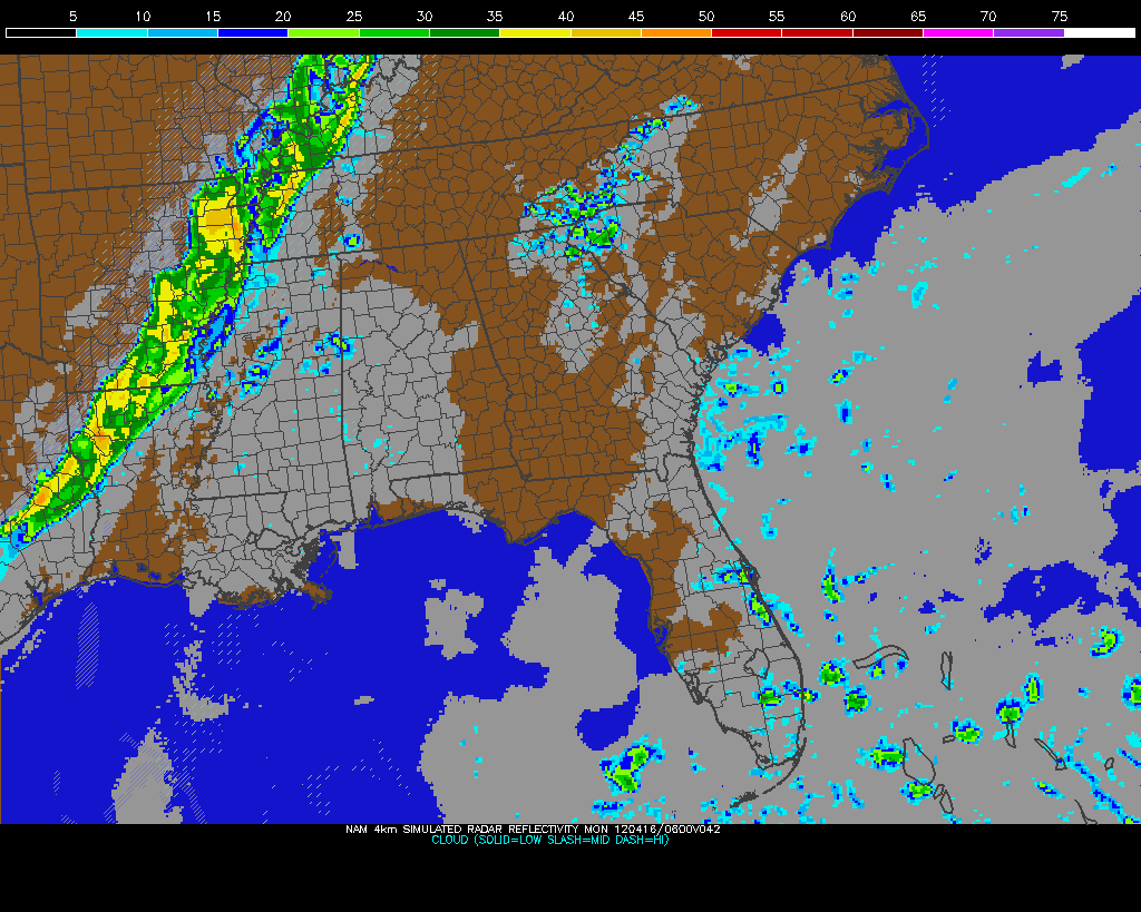
Sunday Night storms on NAM Model
It's a nice weekend across West Tennessee with warmer temperatures and breezy conditions. Another day of 80-degree weather is on the way for Sunday, but storms will roll through the region on Sunday night into Monday morning. Some of these storms could be a little strong, but they shouldn't be terribly severe, if at all, since they will be weakening as they approach the Mississippi River. Rain chances should subside completely after Tuesday and sunshine with highs in the 70's will be with us through the middle portion of the workweek. Check out my video from this morning below for more details!


A potent severe weather outbreak is just getting started in the Plains right now. Areas from Nebraska to Oklahoma are under a rare High Risk of severe weather from the Storm Prediction Center and violent tornadoes are expected this afternoon and evening. Already we've had quite a few reports of tornadoes touching down and doing damage in Kansas this afternoon, and more of the same can be expected as this system pulls more moisture northward and destabilization continues. On the left you'll see the latest EHI chart from the SPC, which is a measure of helicity (spinning motion in the atmosphere) and instability. This is a decent indicator of where the strongest tornadoes could form. It's really ramping up with values as high as 7 in Oklahoma right now, but those values are expected to increase and possibly move northward this afternoon and evening into Kansas and Nebraska.

Be sure and join me again on WBBJ for 7 Eyewitness News at 6 and 10pm tonight!

Wednesday, May 25, 2011

5/25 - 11:30am CDT - Heading to Eastern Colorado / HIGH Risk East

After a very active day of chasing, we're heading to Eastern Colorado to prepare for tomorrow's risk of upslope storms in that area. Yesterday we drove 362 miles across Oklahoma while chasing and you can see a couple pictures and some video that I shot in the post below.


A HIGH Risk of severe weather has been issued by the SPC for West Tennesee, Western Kentucky, Southeast Missouri, Southern Illinois, Southwest Indiana, and Northwest Arkansas. Just a quick look at some data this morning reveals high dew points and winds backing to the south across the region. The satellite picture is also clear for most of Kentucky and Tennessee, so instability is building quite a bit already this morning. Cities like Jackson and Memphis in Tennessee, Paducah, Owensboro, and Louisville in Kentucky, Jonesboro, Arkansas, St. Louis, Missouri, and Evansville, Indiana need to be on high alert for a possible tornado threat this evening.


5/25 - 6am CDT - Oklahoma Tornado Outbreak Yesterday

Rain-wrapped tornado near Piedmont and El Reno, OK
A tornado outbreak unfolded as forecast in Oklahoma yesterday, but unfortunately many of the tornadoes were shrouded in rain as these storms were overly laden with moisture. This not only made them nearly impossible to see, but also very dangerous to chase. We were right in front of but couldn't see the tornado that destroyed parts of El Reno, OK and in fact chased that cell from it's formation in Eakly, OK earlier in the afternoon. I'd venture to say that we were less than two miles from that violent tornado, but all that we could see was a giant grey mess in the distance.

Supercell forming near Eakly, Oklahoma
Later on after a trip through Oklahoma City, we took shelter in Moore, OK because of hail and a tornado passing over I-35 just in front of us as we went southbound. What we didn't know was that the twister took a northward jog and caused damage just a few hundred yards in front of us. Scary, no? It wasn't a strong tornado, but it toppled some power lines and threw some small debris into the interstate roadway. After that tornado passed by we went to survey some damage in Moore and Newcastle since the storms were quickly evolving into a linear system and moving into the heavy vegetation east of Oklahoma City. Check out the video below for all the action from yesterday:

Tuesday, May 24, 2011

5/24 - 11:45am CDT - HIGH Risk in Oklahoma

Yet another tornado outbreak is on the way in the United States today and this time we're going to be smack-dab in the middle of it. A strong cut-off area of low pressure moving across the Plains this afternoon will provide the needed moisture-laden surface winds from the southeast and dry, pushing air from the southwest to create a sharp dry line that will be the focus for storm development this afternoon. Instability values will be off the charts as the cap (thunderstorm-inhibiting layer of warm air above the surface) breaks sometime during the middle of the afternoon. Temperatures aloft today will be slightly warmer than yesterday, so storms should stay isolated, especially south of the Kansas border. Locations near that border will most likely see a similar situation to yesterday, when tons of developing storms merged into an un-chaseable complex. There's a bit of a cloud shield situated vertically across the central part of the state this morning, but it should clear out fairly quick.


The Storm Prediction Center has issued a rare HIGH Risk for Oklahoma and Southern Kansas because of how potent this setup looks. The issuance of a HIGH Risk may not seem rare because of all the destructive outbreaks that have happened this year, but overall they don't issue one but once or twice at the most in a normal season. The risk includes a 45% tornado risk (!), something that has only been used for the devastating April 27th tornado outbreak in the South this year. Needless to say, expectations are high and a lot of folks are nervous around here. We're getting in position right now in Oklahoma and making adjustments as necessary based on conditions.


With such a huge outbreak expected, today is certainly the day that you need to follow me on Facebook and Twitter for my latest chase updates and photos if you haven't already.

5/24 - 6am CDT - Great Supercell Yesterday, HIGH Risk Today

We chased a supercell that formed near Ringwood, Oklahoma yesterday for a few minutes until it merged with other storms and became weaker. We moved to a new isolated cell near Greenfield, OK and it persisted for a while with a few rotating wall clouds. It may not have produced a tornado, but it certainly had the capability and nearly did when one of these wall clouds tightened up considerably. Check out the video below to see it all happen!


The panorama below gives you an idea of how close the wall cloud came to the ground as its rotation tightened:


We traveled 366 miles yesterday on our chase, which took us from Woodward to Oklahoma City, Oklahoma:


The Storm Prediction Center has issued a HIGH Risk for severe weather tomorrow in Oklahoma and Kansas. We stayed in Oklahoma City last night, so we're not far from the action. There's a 30% tornado risk with this outlook, which is the first HIGH Risk of the year for the Plains.


Here's a snippet of the SPC's discussion for today:
VERY LARGE HAIL...DAMAGING WINDS...AND SEVERAL POTENTIALLY SIGNIFICANT TORNADOES APPEAR LIKELY AS THE STORMS INCREASE AND SPREAD ACROSS KS/OK INTO WRN AR AND THEN LATER INTO WRN MO.
I'll have an update later this morning with the latest SPC severe weather outlook and a discussion on today's outbreak along with our target area.

Monday, May 23, 2011

5/23 - 11am CDT - Destruction in Joplin / Today's Chase in OK

The US just can't catch a break from horrendous tornado destruction this year. Last night a very powerful wedge tornado tore through the town on Joplin, Missouri leaving nearly 40% of the town destroyed and 89 dead as of this writing. Many are calling this tornado, which also ripped through a hospital in Joplin, an EF4 tornado. While no official designation will be given to this twister until the National Weather Service completes a survey of the damage, the look of the destruction on TV and online suggests an EF4-like tornado. The pictures coming in look just like Tuscaloosa, which was hit by a similar tornado on April 27th. We were not in Joplin last night because it was too far away from our starting location in Amarillo where we picked up our new tour guests. We also usually don't chase in that area because of the increased vegetation and topography issues. (AP Photo/Charlie Riedel)


This morning we're in Oklahoma getting into position for what could be another active day. The Storm Prediction Center has issued a Moderate Risk for severe weather across much of Oklahoma and unfortunately the hard-hit Joplin area in Missouri. A 10% tornado risk accompanies this severe weather outlook, which you'll find below. Dew points in the upper 60's to near 70 will be more than enough for storm development this afternoon and east surface winds coupled with southwest winds aloft should enhance wind shear. The surface area of low pressure we're watching along the Oklahoma/Kansas border may be dropping south and west this afternoon, so we'll have to follow the good surface winds as they move.


Don't forget that you can follow me on Twitter and Facebook for the latest updates as we're chasing!

Saturday, May 21, 2011

5/21 - 3pm CDT - Back in Amarillo to Prepare for Next Week

We're in Amarillo today getting ready for another tour group to arrive. We washed and vacuumed the van (it was bad from all that Kansas dust), so we're ready for another week of storm chasing. We'll have two vehicles this week filled with excited storm chasing tour guests from all over the world, so it should be a good run.

SPC Severe Probability - Mon
Things are looking quite interesting next week, but we're meeting each risk of severe weather with tempered optimism after the problems that plagued our storms this week. Sunday looks to be a travel/sightseeing day because the risk of severe weather is too far east for us to travel from Amarillo and the terrain/vegetation in that part of the country presents even greater difficulty. Monday, on the other hand, looks pretty good. A surface low near the OK/TX panhandles should move in and deepen considerably throughout Monday, setting the stage for severe storms to erupt in West Oklahoma and Southwest Kansas. We'll likely play the Southwest Kansas component of this risk because of the east winds hitting the up-sloping geography with plenty of moisture in tow. Should be a decent tornado threat with this should it all pan out as the models indicate. The Storm Prediction Center has issued a 30% Slight Risk for severe weather in this area due to these factors.

SPC Severe Probability - Tues
Tuesday will be a very similar setup, just translated 150 miles east. The SPC has already outlined a risk area for Tuesday on their 4-8 day outlook, so they're confident this far out that something may happen. Wednesday, Thursday, and Friday may not be great chase days due to a small bit of ridging building into the Plains, but there's a possibility that a trough may move in soon enough on Thursday to where we may be able to chase in the North Plains of Nebraska and South Dakota. I sense a long drive back to Amarillo on Friday if that happens. The models are indicating that the severe weather setup may shift to the North Plains just in time for us to switch to our base in Denver next weekend. Let's hope so!


As always, you can follow me on Twitter and Facebook for the latest updates on our chase. Storm Chasing Adventure Tours also has a new Facebook page that you can "Like" to receive updates and photos from the group.

Friday, May 20, 2011

5/20 - 11:20am CDT - Off to Western Oklahoma

After a not-as-good-as-we-thought-it-would-be day yesterday, we're off to Western Oklahoma in search of storms that will likely fire this afternoon behind an already ongoing line of storms in the central and eastern part of the state. Upper-level winds should be supportive of storms that could fire this afternoon, but we're still waiting for the atmosphere to recover behind the ongoing storms this morning. Short-range models indicate ample moisture with decent instability in the western part of the state. The dry line, which you can easily see in the dew point forecast image below, will provide a focus for storm formation as outflow boundaries from this morning's storms interact with it. This interaction will create lift to get storms going this afternoon. Temperatures aloft will still be a little cool for really good isolated storm development, but we'll take what we can get.


Be sure to follow me on Facebook and Twitter for the latest updates this afternoon!

Wednesday, May 18, 2011

5/18 - 9:30am CDT - We're Back to Chasing!

It's been a long start to the week since there haven't been any storms to chase here in the Great Plains. That changes today. We're on our way to Oklahoma in search of tornadoes this afternoon, and I think the potential is looking pretty good considering how things have been this week. Moisture is still going to be an issue, but surface dew points should recover somewhat today. That recovery will take time, so storms may not form until later in the afternoon. Easterly winds at the surface and southwesterly flow aloft at 500mb (18,000 ft) should create ample shear for today's setup, meaning any supercells that form will stay discrete and have the associated tornado risk with them. CAPE or instability shouldn't be a problem based on the modeling for this afternoon and the cap (warm updraft-inhibiting layer of air aloft) should break sometime after 3pm. Given these factors, the Storm Prediction Center has issued a Slight Risk for severe storms this afternoon for much of Southwest Kansas and Western Oklahoma with a 5% tornado risk for the Panhandle region through Southwest Oklahoma.


Be sure to follow my updates on Facebook and Twitter for the latest on our storm chasing adventures this afternoon!

Sunday, May 15, 2011

5/15 - 6pm MDT - New Mexico!

Storm Chasing Adventure Tours is in Carlsbad, New Mexico for the evening as we're still waiting for the severe weather threat to ramp up during the middle part of the week. We visited Roswell, New Mexico this afternoon and the associated alien museums and gift shops before heading to Carlsbad where we'll view the bats flying out of Carlsbad Caverns this evening near sunset.

12z GFS dewpoints at 7pm CDT Wed
Tomorrow should be another "touristy" day before we begin seriously looking at the risk for a severe weather event across much of Texas and Oklahoma on Wednesday, Thursday, and Friday. The latest models have moisture streaming back into the region nicely, but we're keeping a close eye on it. You can see the dewpoints rising near the Oklahoma/Texas border on the right-hand image from the GFS model. Should moisture return as advertised, things should shape up nicely for mid to late week. Three or more good days of chasing in a row? That sounds good to me!

Friday, May 13, 2011

5/13 - 12:15am - National Weather Center / Amarillo

We visited the National Weather Center in Norman, Oklahoma this morning. This facility located on the University of Oklahoma's campus is home to the Storm Prediction Center, National Severe Storms Laboratory, and other branches of the National Weather Service.


We're making our way back to Amarillo, Texas so that our current tour guests will be able to fly out tomorrow morning. There are no storms to chase today because of the aforementioned low risk of severe weather across the Plains for the next few days. Luckily, things will be picking up around the middle of next week!