Showing posts with label EHI. Show all posts

Tuesday, January 29, 2013

1/29 - 5:45pm - Serious Severe Weather Concerns Tonight

Latest Severe Weather Updates


A severe weather setup that we see normally in the springtime is about to unfold on this late January night across a large expanse of the Southeast. While not "unprecedented" or "once-in-a-lifetime", this outbreak is going to impact quite a few people and it's important that everyone have what they need to be prepared and safe. This post is mainly for folks in North Mississippi and West Tennessee, but you can figure out pretty well how you'll be affected if you're not in these areas by some of the maps and information below. Everyone needs to be aware of what's going on because this will be happening at a very bad time of night when even the night owls are asleep.

Fast Facts

A MODERATE Risk of severe weather has been issued by the Storm Prediction Center for the overnight hours in West Tennessee and most of North Mississippi. Tornadoes, damaging winds, and hail are all on the table for these areas as storms move through. Even though places like the Golden Triangle in Mississippi are just outside of the Moderate Risk area I would treat this as if you were in it because these storms are going to be very, very strong still as they move through this region. Please, please, please have a weather radio or smartphone app that's armed and ready to alert you if a Tornado Warning is issued for your location tonight. This will be hitting when most people are asleep so it's a very dangerous situation.

Timing - North MS and West TN

8pm - Midnight - Small chance for some isolated storms. These would carry a tornado, wind, and hail threat.

Midnight - 2am - Slightly better chance for isolated storms, small line of storms may try to form ahead of main line.

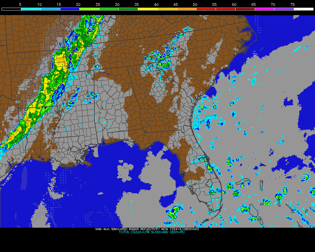
2am - 7am - Main line of severe thunderstorms moves through. This will affect everyone. Tornadoes, severe damaging winds, and hail are a good bet during this time.

Discussion

A line of storms stretches from the Great Lakes to Texas right now and will continue to move eastward through the evening. A few reports of severe weather have come in already from this but the main show will be overnight as this line of storms encounters a more rich environment for severe weather.

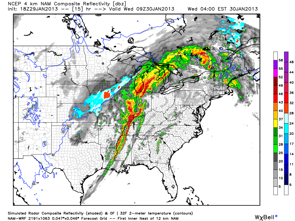
The main storm mode for tonight will be a squall line of storms with embedded rotation in portions of it (AKA what's termed a QLCS). Supercell storms will be possible ahead of the main line of storms too and could easily produce tornadoes if they develop. Tornadoes in QLCS lines of storms like the one we'll have tonight are more difficult to identify on radar since they're embedded within the line. While not as strong as supercell tornadoes, QLCS tornadoes can be strong and cause massive damage in the right environment.

While directional shear, which is needed to produce tornadoes, isn't very good for this event, the speed shear or tendency for winds to increase in speed with height will be very good. But, the directional shear may just be enough to cause problems. When you combine helicity (caused by shear) with instability in a formula you get what's called the Energy Helicity Index (EHI). This, in my mind, is a good determinant of tornado ingredients in an environment. The NAM model has increased levels of the EHI throughout West Tennessee and Mississippi tonight as this squall line is moving through so these QLCS tornadoes may have some kick to them if they develop. Not good news at all.


Also, since winds at 850 mb (about 5,000 feet) will be howling it will not take much for any part of this line of storms to pull these winds down to the surface and create straight-line wind damage. I wouldn't be surprised if folks affected by the worst of these winds thought they were hit by a tornado. I'm hearing the word Derecho being thrown around a bit with regard to how this system will develop tonight. That's certainly a possibility with this system but I think it's a relatively small chance.

One more thing to mention, and this is not the least important at all, is the fact that moisture and warm air continues to stream in from the south in advance of this system. When the dry line that's triggering these storms hits this richer air tonight you'll know. The whole line of storms should really begin to light up by then. Having air this warm and moist in January is never a good thing because Mother Nature intends to correct it in a violent way.

Follow me on Twitter and my Facebook page for the latest updates tonight!

Saturday, July 7, 2012

7/7 - 10:30pm - Massive Heat Wave Ends with Storms

Today capped off the longest, hottest stretch of weather in Louisville that most people can remember. Today's 106° high at Louisville International Airport was the hottest it's been since July 14th, 1936 when it got to 107°. That temperature is Louisville's all-time record high and if we didn't have as many clouds as we did this afternoon in the city we would have met or broken it. This ends nine days of 100°+ weather, which is the third-longest stretch of triple digits ever recorded according to NWS Louisville.

Storms that will develop tomorrow will be ushering in cooler temperatures, which is welcome news! The bad part is that some of these storms may be severe due to the incredible amount of energy they'll have at their disposal from all the heat. Temperatures in the mid 90's tomorrow with sunshine and high humidity will power an awful lot of instability, or the tendency for air parcels to rise and create thunderstorms. A cold front sinking down from the north that will be stalling out once it passes just to our south will be the focus for storm chances starting tomorrow in the early afternoon in Louisville and lasting through Monday morning.

The main threats from these storms will be wind and hail, but there could also be a threat for some rotating storms too. While winds don't look favorable for any sort of big tornado problems tomorrow, a couple of these rotating storms may get just enough juice to put down a brief spin-up. EHI values in the adjacent image take into account both instability and helicity, which is a product of wind shear. The elevated values you see are powered mostly by instability and just a little bit of helicity, so again, winds aren't that favorable here. The Louisville area is no stranger to summertime tornadoes as you may remember a series of four of them that touched down in late June of last year.


Given the chances for some severe wind and hail tomorrow, the Storm Prediction Center has issued a 15% Slight Risk area for Kentucky. A better chance for severe weather (30%) exists closer to the East Coast where upper-level winds will be stronger as a trough digs down a bit into that area.

Tuesday, June 26, 2012

6/26 - 10:40am MDT - Another Day, Another State

Yesterday near the Black Hills of South Dakota we saw a few storms develop but they never got organized enough to be good for chasing. One storm in particular had some promise but it just couldn't get strong enough to leave the elevation of the Black Hills where its updraft was rooted. Today we're going north from the Black Hills and moving into North Dakota where there should be a threat for severe storms this afternoon. In particular, areas near and just west of Williston, North Dakota into extreme Eastern Montana appear to be under the greatest threat since a few isolated storms could produce hail, wind, and maybe even an isolated tornado. The Storm Prediction Center only has a general thunderstorm risk for this area but there's a 2% tornado risk included. You'll see the Slight Risk up there in Montana as well in the map to the right, but that area is very remote and the surface winds likely won't cooperate as well for storms like they will in North Dakota.

Winds aloft are forecast to be stronger in our target area today than they were yesterday in South Dakota since the upper-level disturbance over the northwestern part of the country will be moving east a little. When you couple these stronger southwesterly winds aloft with southeasterly winds at the surface that can create some shear for rotating storms. It's worth noting that the best surface winds could be in Canada just north of North Dakota and Montana since an area of low pressure will be spinning winds around from the east there. Since we can't go to Canada, that's obviously out. Dew points in North Dakota are downright soupy this morning and will likely continue to be that way through the afternoon. Having 70 degree dew points right on the Canadian border is something you don't see too often.

With all the warm air and moisture in place, instability will be plentiful for storms. I talked about the threat of isolated tornadoes today on the SPC's outlook and that may very well verify if the instability and shear come together. A great way to combine those two factors is to look at the Energy Helicity Index, which starts getting higher in an isolated spot in Western North Dakota according to the RAP Model. We'll see if it's enough to get some good storms going this afternoon and evening!

Keep up with our chase today by following me on Twitter and Facebook!

Sunday, June 24, 2012

6/24 - 10:35am MDT - The Chase Begins!

This morning we're heading toward Cheyenne, Wyoming from Denver as we continue to look at weather data coming in. Today's setup still looks marginal by most accounts, but there are a few small features that could cause a few isolated storms to go severe. For one, surface winds out of the east in Wyoming, Northeast Colorado, and Nebraska will generate upslope flow, which is the lift mechanism we need to get storms going.

These winds will also create some shear because they will be interacting with southwesterly winds at 500 mb (18,000 feet). The issue with this is that the faster winds at this level will be further north toward Rapid City, South Dakota instead of where the more favorable surface winds will be just to the south. In any case, the wind direction at 500 mb will be good enough to usher in the wind shear and maybe some drying of the air at that level to increase instability.

When you put the expected helicity (caused by wind shear) and the instability together for today, you get the Energy Helicity Index (EHI). According to the 14z RAP model, the EHI may try to ramp up a little bit in Northeast Colorado and it even breaks out a little bit of precipitation just west of there too. Surface heating is going to be massive since temperatures will be in the 90's and 100's in some places, so we're hoping this also helps overcome some of the warm temperatures aloft (the cap) so that isolated storms can develop. We're grasping for small features today since there isn't any one thing jumping out to get our attention, but so far it looks like a storm or two could fire on the elevation near Cheyenne. We'll also be watching an area closer to Rapid City, SD to see how things develop up that way.

Follow my continuous chase updates on my Twitter and Facebook accounts today!

Friday, May 25, 2012

5/25 - 11:50am CDT - A Grand Finale

Ever since earlier this week we've had our eye on today's setup in Central Kansas. The moisture return, a low developing over Southwest Kansas, and upper-level wind support all kept us coming back to look at the models to see how it was shaping up. For a while it looked like the cap, or a layer of instability-inhibiting warm air aloft, was going to surpress storm formation but now we're seeing a situation where there will be just enough break in the cap to allow for a few isolated supercell storms to form. To get surface heating today to break that cap we need to clear out the clouds across Kansas first. A push of dry air at around 10,000 feet is currently moving from Southwest Kansas to the northeast and is eating these clouds for breakfast as you see in the satellite image to the right. We expect this to keep moving throughout the day and hopefully it will clear out the clouds in time to get some serious surface heating going.

The big story here today is the moisture return. For the first time this week we are seeing a situation where dew points will surge into the mid to upper 60's. Yes! This much-needed moisture will be the fuel for storms this afternoon and should give us a much better show than the moisture-deprived low-precipitation storms we've been seeing lately. While we don't have this moisture in the area quite yet, it's streaming in like crazy right now. Strong easterly and southeasterly winds are blowing this moisture into Kansas from Missouri and Oklahoma and will continue doing so throughout the day. Having mostly easterly winds in Kansas right now is a very good thing because this is creating just about optimal low-level shear for rotating supercell storms.

Speaking of wind shear, this will create quite a bit of helicity, or a corkscrew-like rotation of air in the atmosphere. When you combine helicity with instability in an equation you get the Energy Helicity Index (EHI). As I've said before I think that indicies and parameters can be distracting since human analysis is always better than a formula, but EHI seems to be fairly reliable since it is so basic and relies on two very basic ingredients. This afternoon's EHI values in Kansas will be the highest we've seen out here this season according to the Rapid Refresh model. That's some great news for storm chasers because higher EHI values typically correlate with enhanced tornado potential.

The Storm Prediction Center has a Slight Risk for severe storms today from Iowa to the Texas Panhandle and within that a 5% tornado risk in Kansas. This is quite the change from the previously non-severe "general thunderstorm" outlooks that they had been issuing for today because of the concern that strong capping may inhibit storm development. Today is our last chase day out here for Tour 3 and my last day out here until I come back for a week in June. If we could see some good storms today that'd be a great end to the first part of my trip! Tonight once we're finished chasing we'll be traveling back to Oklahoma City where I'll fly back to Louisville from tomorrow morning.

Follow up-to-the-minute reports on our chase on my Twitter and Facebook accounts!

Saturday, May 5, 2012

5/5 - 11:55pm CDT - Interesting Setup Tomorrow

A cold front moving through the Plains tomorrow will provide the focus for severe storm development during our first chase day. This front has really slowed down on the computer models over the past day or so and this is good because it will allow the warm sector environment to to east of it to become richer with potential due to solar heating. Something the NAM model has been consistently picking up on is the development of a small, sharp shortwave moving through Oklahoma during the afternoon. This shortwave generates a secondary low on that model that creates some pretty good directional shear over Central Oklahoma. Couple that with some incredible instability due to the high moisture in the area and you've got an interesting little severe weather setup to chase. This setup has shifted around from North Texas to East Kansas over the past few model runs, but it seems to be stabilizing over Central Oklahoma for now. The tornado risk tomorrow originally looked very slim due to the lack of good wind speed aloft, but now it is becoming hard to ignore the good directional shear and the great instability. So while it still isn't a high tornado risk, I would venture to say that one or two may touch down if indeed this area of good directional shear sets up.

I'll have an update tomorrow morning on how the setup has evolved and where we'll be targeting. Follow my up-to-the-minute updates on Twitter and Facebook.

Saturday, April 14, 2012

4/14 - 2:30pm - Nice West TN Weekend, Outbreak in the Plains

Sunday Night storms on NAM Model
It's a nice weekend across West Tennessee with warmer temperatures and breezy conditions. Another day of 80-degree weather is on the way for Sunday, but storms will roll through the region on Sunday night into Monday morning. Some of these storms could be a little strong, but they shouldn't be terribly severe, if at all, since they will be weakening as they approach the Mississippi River. Rain chances should subside completely after Tuesday and sunshine with highs in the 70's will be with us through the middle portion of the workweek. Check out my video from this morning below for more details!


A potent severe weather outbreak is just getting started in the Plains right now. Areas from Nebraska to Oklahoma are under a rare High Risk of severe weather from the Storm Prediction Center and violent tornadoes are expected this afternoon and evening. Already we've had quite a few reports of tornadoes touching down and doing damage in Kansas this afternoon, and more of the same can be expected as this system pulls more moisture northward and destabilization continues. On the left you'll see the latest EHI chart from the SPC, which is a measure of helicity (spinning motion in the atmosphere) and instability. This is a decent indicator of where the strongest tornadoes could form. It's really ramping up with values as high as 7 in Oklahoma right now, but those values are expected to increase and possibly move northward this afternoon and evening into Kansas and Nebraska.

Be sure and join me again on WBBJ for 7 Eyewitness News at 6 and 10pm tonight!

Friday, March 2, 2012

3/2 - 12:30am - Severe Weather Outbreak Likely

A potent severe weather setup looks likely this afternoon and evening for Tennessee, Kentucky, Alabama, Mississippi, and even parts of Indiana and Ohio. All the ingredients are coming together for what could be a sizable tornado outbreak in these areas, especially around Middle Tennessee and Central Kentucky, maybe extending into Indiana too. We've had severe weather in some of these places just earlier this week, but this setup looks to be even more potent than that. Cities like Louisville, Lexington, Cincinnati, Nashville, Bowling Green, KY, Huntsville, Jackson, TN, Tupelo, MS, Starkville, MS, and Birmingham need to be on the lookout today.

Risks and Timing

The Storm Prediction Center has outlined a Moderate Risk area for severe weather tomorrow in an expansive area of the South. This includes a 15% tornado risk. Storms will likely erupt early this morning as a warm front surges northward and bring a hail risk to West Tennessee while not-as-strong storms will affect the most of the remainder of Kentucky, Tennessee, and Mississippi. These storms shouldn't be a huge deal, but a few might reach severe limits.

A brief break in the action throughout the mid and late morning hours should provide enough recovery time for the atmosphere to recharge and re-fire storms around noon. These storms will try to get going in West Tennessee and Northeast Arkansas, but will gain strength as they hit areas of greater surface heating to the east. These are the storms that could be very bad in a lot of areas. The worst tornado threat throughout the afternoon will be in Central Kentucky and Middle Tennessee, but there's a secondary area that could have tornado problems in Northeast Mississippi into North Alabama if a little more low-level wind shear comes into play. The Storm Prediction Center's latest severe weather outlook seems to pick up on that secondary tornado risk area by extending the Moderate Risk down to East Mississippi and Alabama. Straight-line wind damage and hail will be possible throughout the South tomorrow, so even if you're not in an area where tornadoes will be likely you need to be on the lookout for severe storms. The storms should move out quickly tomorrow evening once the cold front accelerates southeastward through the region.

Details

The reason why Central Kentucky to Middle Tennessee will be the area for maximum tornado potential tomorrow is because of an alignment of a few factors. For one, the fastest upper-level winds will be centered right over this area tomorrow afternoon. When you couple that with almost southerly winds (may be a bit southwesterly at times), you get not only a high difference between wind speed aloft and at the surface, but also a difference in direction. This is called wind shear and it's crucial to sustaining a thunderstorm and allowing it to become strong enough for tornado development. The southerly winds at the surface will help what's called low-level wind shear, and that's usually a pretty big factor in who gets tornadoes.

These southerly winds will also be bringing in moist air from the Gulf, which is the fuel for these storms as they develop. While the best moisture will be over Mississippi, Alabama, and Tennessee tomorrow, it will still be ample for serious severe weather in Kentucky. This moisture will bring some serious atmospheric instability to the region. When you couple this instability with helicity (the tendency for the atmosphere to rotate), you get what's called the Energy Helicity Index (EHI). This is a decent indicator of where the best tornado ingredients will be, and as you can see on the left, the values are particularly high tomorrow across a pretty vast area from Mississippi through Kentucky. Supercells appear likely in Tennessee and Kentucky, but Northeast Mississippi may have more of a mixed supercell/squall line of storms scenario due to less wind shear. This could be an entirely linear squall line event across Northeast Mississippi/North Alabama tomorrow if wind shear under performs. While squall lines don't harbor as many strong tornadoes, it is still a very real threat that needs to be monitored.

Safety

Before severe weather
  • Make sure your cell phone is charged in case you lose power
  • Have flashlights with fresh batteries ready to go. Your cell phone should NOT be your primary flashlight
  • Your NOAA Weather Radio/Cell phone alert app should be ready to alert you
  • Make a central meeting location for family members should you lose communications after the severe weather passes
I've said before that I like iMapWeather Radio on the iPhone for weather alerts. This is not any sort of endorsement, but it is an app that I use and it just works.

When a Tornado Warning is issued for your area
  • Get to the lowest level of your home, apartment, or office
  • Stay away from windows and try to get to the center of the structure you're in
  • Evacuate mobile homes and get to a safe, sturdy building immediately
  • Make sure you are wearing sturdy shoes
  • If you have time (have these ready to go before a warning is issued), put bicycle helmets on the kids and yourself. Quite a few deaths were caused by head trauma in last year's tornadoes.
Please heed ALL warnings. This is a dangerous severe weather setup that needs no playing around with.

Wednesday, February 22, 2012

2/22 - 3pm - Severe Storms Possible Tomorrow Across the South

Let's start with today first. It's unbelievably nice outside! You can't get much better than this in February in North Mississippi. You may be thinking that we'll have to pay for this great weather with some sort of severe weather event, and you're correct. This warm, moist air will serve as the fuel for a few severe storms across the region tomorrow night (see right for the SPC's latest Slight Risk area).


The main issue with the forecast at this point is where and exactly when will these storms form? The computer forecast models are having a difficult time figuring out if a warm layer of air aloft will serve to suppress storm development during the evening. This layer of air, which is called the "cap", is something that storm chasers in the Plains have to deal with quite often but usually not something we deal with here in the Southeast. Even though the models are having a hard time with this, we'll likely see a squall line of storms (QLCS in weather nerd lingo) roll through sometime around or after midnight tomorrow night. These will likely carry wind damage and hail threats, but the latest data coming in suggests that we may even see a couple isolated tornadoes. This will certainly not be a tornado outbreak by any means because the wind shear profiles for that kind of thing just aren't there. The energy helicity index (a combination of rotation in the atmosphere and instability) output on the left from the 18z NAM shows that this squall line will have some tornado ingredients to work with, but not all that much.

Another reason why we won't see a more significant severe weather risk is because the amount of moisture that we'll have filtering into the region from the Gulf won't be as strong as previously thought. Dewpoints just above 60 (on right) are certainly enough to trigger severe storms, but something closer to 70 is needed for more potent setups. Check out the video below for more details on this system:

Wednesday, June 2, 2010

6/2 - 10:40am CDT - We're Headed West!

After much excitement on Monday, yesterday was quite a bit more subdued as the storms that were expected to form organized into a non-chaseable linear line that pushed east towards Omaha, NE. We're not real optimistic about today's setup in the Texas Panhandle, which includes a Slight Risk from the SPC, so instead we're headed to West Nebraska where there's a chance for a few storms. CAPE values (instability - see left image) of over 1500 J/kg and forecast EHI values near 2 should hopefully give us something to work with this afternoon around that area.

As usual, if we see any good storms we'll be streaming live at http://stormchasertv.com. You can also follow my chase updates on Twitter and Facebook.

Friday, May 21, 2010

5/21 - 10:30am CDT - Another Day of Chasing Begins

We're on the road heading to Amarillo from Abilene after chasing in Central Texas yesterday. We'll be arriving in the Panhandle in just a few hours to begin chasing storms that will form as the dry line pushes east this afternoon. Strong southeast winds at the surface and southwest winds aloft will create good shear today. CAPE values (instability) will be over 2500 J/kg according to the latest RUC computer model run, which will be more than enough for good storm development. There will be more CAPE and higher EHI values in Eastern Colorado today, but we're thinking that moisture may be a bit of an issue up there, so the Texas Panhandle seems to be a good target area. The SPC has also issued a Slight Risk for this area as well, including a 5% tornado risk.

As always, we'll be streaming LIVE video at http://stormchasertv.com when we're actively chasing. Don't forget to follow me on Twitter and Facebook for the latest chase updates!

Monday, May 17, 2010

5/17 - 11:30pm CDT - We Saw a Funnel Cloud in Texas Today!

About an hour after we left Carlsbad Caverns in New Mexico, storms began to form from the mountains of West Texas to Roswell, New Mexico. We intercepted the strongest of these supercells just north of Kermit, Texas and began to follow it as it progressed northward. As we stopped on the side of the road to watch it, a small funnel dipped down from the updraft base a few miles away and sent us scrambling for our cameras (it wasn't a terribly impressive storm so nobody had their cameras ready!). The funnel lasted for only a few seconds, so by the time I had scraped my leg up badly on the thorny Texas brush trying to get my camera out of the SUV, it had disappeared. It was definitely a funnel because it was very smooth and had obvious rotation. That was about all the action we saw today because the numerous supercells around the region began to merge into a line after contaminating each others' inflows with cold outflow air.

Today was good because we got to at least see a storm (and a funnel!), but tomorrow should be better because the storms will have a fighting chance at being tornadic. A low in New Mexico will slide north slightly tomorrow, which will trigger southwest winds in East New Mexico and easterly winds south of Lubbock, Texas. 500mb diffluence over West Texas will cause air to rise from the surface and a fast jet at the upper levels will begin to creep into the area tomorrow evening. Something we did not have on our side today was good shear, but tomorrow will be much improved with bulk shear values over 60 kt. Energy Helicity Indicies (EHI) of over 1 near Lubbock won't hurt either, so I think things will come together tomorrow for a better chance of some good supercells. The SPC has issued a 30% Slight risk area for tomorrow, so it seems they're seeing the setup come together like we are.

5/16 - 10:45pm MDT - Not Much Happening in New Mexico

It seems that a layer of warm, moist air at the mid levels of the atmosphere kept things pretty tame here in New Mexico today. Storms tried to get going, but developing updrafts would hit that warm layer and simply come to a halt, spreading outward instead of upward. A few thunderstorms eventually formed near sunset, but they were very weak and didn't have a snowball's chance on Mercury of producing a tornado. Basically, we had most of the elements (shear, warm surface layer, etc), but the air in the mid levels just would not allow things to go.

We'll be touring Carlsbad Caverns tomorrow morning before we set out for tomorrow's chase in the afternoon. It looks like we'll be chasing south of Lubbock, TX again as an area of low pressure in Mexico moves northward and brings southeasterly winds to West Texas. A cold front associated with a low in the Ohio Valley will also translate southward through most of Texas tomorrow, which may provide some lift. Even though instability looks good, shear and EHI values aren't looking great on the 0z NAM computer model. The SPC has issued a Slight risk for severe weather tomorrow south of Amarillo, but I'll hold off on making judgment on tomorrow's chase until the morning. A lot can happen overnight as computer models and surface conditions change. Let's just hope the storms actually form tomorrow! 

Tuesday, May 11, 2010

5/11 - 11am CDT - South Oklahoma

We're on our way to Southern Oklahoma to try our luck with storms that will form late this afternoon. An area of low pressure in Colorado will generate southeasterly winds throughout South and Central Oklahoma, but the more preferred easterly winds will be in Northern Oklahoma. But since there will be more moisture and instability to the south, we think somewhere just south of Oklahoma City seems to be a good target area for today. Shear will not be as intense as yesterday, but I think it will be ample for severe storm development. EHI values, which are decent indicators of supercellular and tornadic development (see left image) will be pretty high in this area as well. The good thing is that any storm that forms will be moving about 30 mph, which is about half of the speed they were moving yesterday.

As always, we'll be streaming LIVE video at http://stormchasertv.com when storms begin to form today. You can also get updates on our chase and when we'll be streaming video on Twitter and Facebook.

Saturday, May 8, 2010

5/8 - 3pm CDT - Just Arrived in Amarillo, TX!

Hello from Amarillo, Texas! It's only 62 degrees right now, making my choice of travel attire (shorts and a t-shirt) seem a little off. Luckily, it will warm up here tomorrow as we drive out to start chasing.

This evening the arriving tour 2 group will meet for orientation. We'll go over the basics of storm chasing, safety precautions, and a few housekeeping items. After orientation we'll pile in our vehicles and head to our traditional first dinner of the tour at The Big Texan. This place is quite the tourist attraction, with signs in the airport and around town advertising their "Free 72 oz. Steak" (if eaten within one hour). I think I'll stay with my 8 oz. sirloin, thank you.

Now, on to more important things. We'll probably end up chasing tomorrow somewhere in Central or West Texas based on what the computer models are saying right now. No particular parameter looks very impressive, so we may not see any storms to write home about. We'll see what the situation looks like in the morning.

Monday is when the action cranks up. A severe weather outbreak has been forecast for Oklahoma, Southern Kansas, and North Texas for quite a few days now and things certainly aren't backing down now with the Storm Prediction Center issuing a 30% risk for severe weather for the region. The NAM and GFS computer models have CAPE values well over 3000 J/kg in Central Oklahoma, which is just phenomenal for supercell development. Bulk shear values are topping 70 kt and dewpoints will be in the upper 60's throughout the area, so neither of those are limiting factors. The NAM is also indicating EHI (Energy Helicity Index - combines helicity and instablity) values over 6 in West Central Oklahoma. Values over 5 are considered to be good indicators for strong EF4 and EF5 tornadoes, so there's much excitement in the storm chasing community right now over this outbreak. I do want to caution that a few storms that will be exiting Eastern Oklahoma and Kansas on Monday morning, which could contaminate the atmosphere a little bit and limit heating. Here's what the Storm Prediction Center has to say about that:

BANDS/CLUSTERS OF ELEVATED TSTMS ARE EXPECTED TO BE ONGOING EARLY MONDAY ACROSS PORTIONS OF ERN KS/OK OWING TO A ROBUST WAA REGIME WITHIN A BROAD 45-50 KT SSWLY LLJ.  THIS ACTIVITY MAY PROVE PROBLEMATIC FOR A NWD EXPANSION OF THE WARM SECTOR MONDAY AFTN AND THIS UNCERTAINTY WAS THE PRIMARY REASON FOR NOT UPGRADING TO A MDT RISK.

On a brighter note, they also had this to say about the good shear I mentioned earlier:

FCST HODOGRAPHS EXHIBIT STRONGLY VEERING LOW-LEVEL WINDS WITH THE COMPLETE VERTICAL PROFILE SIGNATURES INDICATIVE OF HISTORIC STRONG TORNADIC CASES.  VERY LARGE HAIL WILL ALSO BE POSSIBLE.

That's some pretty strong wording there coming from the SPC. I think we're going to have a wild day of chasing on Monday if things come together as anticipated.