


 Today capped off the longest, hottest stretch of weather in Louisville that most people can remember. Today's 106° high at Louisville International Airport was the hottest it's been since July 14th, 1936 when it got to 107°. That temperature is Louisville's all-time record high and if we didn't have as many clouds as we did this afternoon in the city we would have met or broken it. This ends nine days of 100°+ weather, which is the third-longest stretch of triple digits ever recorded according to NWS Louisville.
 The main threats from these storms will be wind and hail, but there could also be a threat for some rotating storms too. While winds don't look favorable for any sort of big tornado problems tomorrow, a couple of these rotating storms may get just enough juice to put down a brief spin-up. EHI values in the adjacent image take into account both instability and helicity, which is a product of wind shear. The elevated values you see are powered mostly by instability and just a little bit of helicity, so again, winds aren't that favorable here. The Louisville area is no stranger to summertime tornadoes as you may remember a series of four of them that touched down in late June of last year.


 |
| Ridge breaking at 500mb on Wed. |
 So far we've had 40 days with highs at 90 or above in Louisville, with 18 consecutive days at 90 or above on our current streak. At this point last year we were counting 46 days in the 90's so far, so it seems this summer is a fairly close repeat of last.


 Check out the dew point output from the GFS for early Wednesday on the left. Those dew points are a good 15 degrees lower than the average this week and that translates to markedly lower humidity. That won't last long though... higher dew points with the same old hot temperatures will be back before the weekend. Until then, remember that an Excessive Heat Warning continues for the Louisville area until Sunday night. Stay safe!
 93° in Louisville is hot on its own, but when you couple that with a very high 77° dew point (which puts relative humidity at 60%), you're talking about a heat index of 107°. We're well on our way to a high near 97° this afternoon. It's just hot. An Excessive Heat Warning, on left shaded in purple, remains in effect for the entire Louisville area until Saturday night as heat index values soar past 110° during the maximum heating of the day. Regardless of where you're from and the weather you're used to, your body cannot sustain itself in the hot, humid air we have in Louisville and much of the Midwest right now. Be sure to drink plenty of water and limit your activity outside this week to avoid heat-related illness.
 |
| NC State Climate Office |

 Many areas across Louisville saw heavy rain yesterday as scattered storms slowly made their way through the area. A setup like that will likely happen this afternoon as well with storms again coming from the north. Any chance of severe storms will stay to our north as the ingredients for this will be in better supply. Look for a high just over 90 degrees this afternoon in the city and a degree or two lower in the suburbs.
 |
| Disturbance over IN at 700mb |
 The whole evolution of the MCS and exactly who it will affect most is still murky at this point, but it seems the parameters for severe weather will be in place and the SPC has issued a 15% Slight Risk for the region. Damaging winds from bowing segments and even a few spin-up tornadoes are possible with this MCS tomorrow, so be on the lookout for warnings as they're issued.
 |
| Ridge over Central US on Wednesday |
 |
| Thursday Eve. temperatures (GFS) |
GFSX MOS (MEX)
 KSDF   GFSX MOS GUIDANCE   7/16/2011  0000 UTC
 FHR  24| 36  48| 60  72| 84  96|108 120|132 144|156 168|
 SAT  16| SUN 17| MON 18| TUE 19| WED 20| THU 21| FRI 22|
 X/N  89| 73  93| 75  95| 78  96| 79  98| 78  99| 78  97|
 TMP  85| 75  88| 77  90| 80  91| 81  92| 80  93| 80  91|
 DPT  69| 70  69| 72  70| 75  74| 75  72| 72  71| 71  70|
 CLD  PC| PC  PC| CL  PC| PC  PC| PC  PC| PC  PC| PC  PC|
 WND   6|  6   7|  6   9|  9   9|  9   8|  7   8|  7   8|
 P12  24| 13  14|  7   9| 19  40| 27  20| 12  25| 14  19|
 P24    |     19|      9|     40|     40|     25|     34|
 Q12   0|  0   0|  0   0|  0   1|  0   0|  0   0|  0    |
 Q24    |      0|      0|      1|      1|      0|       |
 T12  26|  8  32| 10  24| 37  49| 49  39| 29  28| 21  36|
 T24    | 30    | 40    | 50    | 71    | 49    | 44    |
 Here we go again. It's already 87° with a dew point of 81° in Louisville and we're just getting started. See that condensation on my door to the left? That started at 10pm last night when the temperature dropped a couple degrees and just now cleared up with sunlight and a bit of heating. That's some crazy humidity right there. I think we'll get near yesterday's high of 97 again today, but like yesterday the dew point is the bigger story. With such a high temperature and high dew point in the low 80's (which is almost unheard of in Louisville), heat index values will be exceeding 110° again. An Excessive Heat Warning has been issued that goes from 11am this morning to 8pm this evening.
 ...But wait! There's more. We're under a Slight Risk from the Storm Prediction Center for severe weather this afternoon as a cold front approaches the area from the north. This is mainly a wind threat (notice the 30% wind risk red area on the right), but there's also a small chance for hail. A lack of wind shear and helicity (turning of the atmosphere) will eliminate any tornado threat for the most part. This front should be the trigger for some southward-moving clusters of scattered storms this afternoon. With all the heat energy and moisture in the area, there's no question that some of these could reach severe limits as the SPC indicates. Not everyone will see storms this afternoon, but those who do will receive quite a bit of rainfall, lightning, damaging wind, and a break from the heat. The cold front is positioned just south of Indianapolis right now and is moving fairly slow, so there will be quite a bit of time for storms to fire today and tonight before the front passes through sometime early tomorrow.


 Today felt so hot because the dew point was near or at 80° for a good portion of the afternoon. That's a rare occurrence and signals the presence of an intense amount of moisture in the air. Humid is an adjective that doesn't even describe how it felt. Tomorrow should be almost as hot with the high topping out near 93 and heat indices near 110. This has prompted the National Weather Service to issue another Heat Advisory from 1pm to 8pm tomorrow. A "cold" front accompanied by a little southward dip in the jet stream (a trough) will increase scattered thunderstorm chances tomorrow afternoon in Louisville. The Storm Prediction Center places us under a Slight Risk for severe weather, mainly due to the threat for some hail and strong winds. The chance for storms could continue into Wednesday morning as the front passes through, but the lack of surface heating should suppress most of the development. We should dry out for the rest of the week with highs near 90. Stay cool out there!

 Most of West Tennessee is under an Excessive Heat Warning until tomorrow at 10pm. Jackson could get up to 100 tomorrow with Memphis easily passing into the triple digits. Heat indices near or above 110 are expected, so limit your time outside if possible and drink lots of water.


 We have had 57 days in the 90's or higher so far this summer in Louisville and there could be many more ahead as this brutally hot weather continues. It's going to get even hotter this week as the current ridging pattern stays in place, with temperatures expected to creep closer to 100 through Saturday. A Heat Advisory is in place through Friday, but I think a couple more Excessive Heat Warnings could be issued for us over the next few days. Like today, showers and thunderstorms could develop in the intense heat and spare some communities from the excessive temperatures over the next few days. As a cold front approaches the area by the end of the weekend, we'll see a better chance for rain and temperatures dipping (relatively speaking) into the lower 90's.
 After a couple days of 96 degree weather in Louisville, we're on-track for a cool-down today. How much of a cool-down? Try four degrees. Yep, it's going to be another hot one today. With dew points in the lower 70's today, the heat and humidity will combine to produce heat index values at or above 100. No Heat Advisory will be issued, but it'll still be hot enough to cause problems if you're not hydrated. The other feature of our weather today will be the chance for some showers and thunderstorms around the region. A cool front that's situated just north of the Ohio River will provide a trigger for these scattered storms today, which should begin to form this afternoon. We're just outside of a Slight Risk area for severe weather from the SPC, but I think a few storms around the region could get strong due to increased atmospheric instability and a light touch of shear. A small daily chance for storms will exist through the rest of the week with temperatures hanging around in the lower 90's.
Today: Mostly sunny and hot, with a high near 121. Calm wind becoming south between 4 and 7 mph.


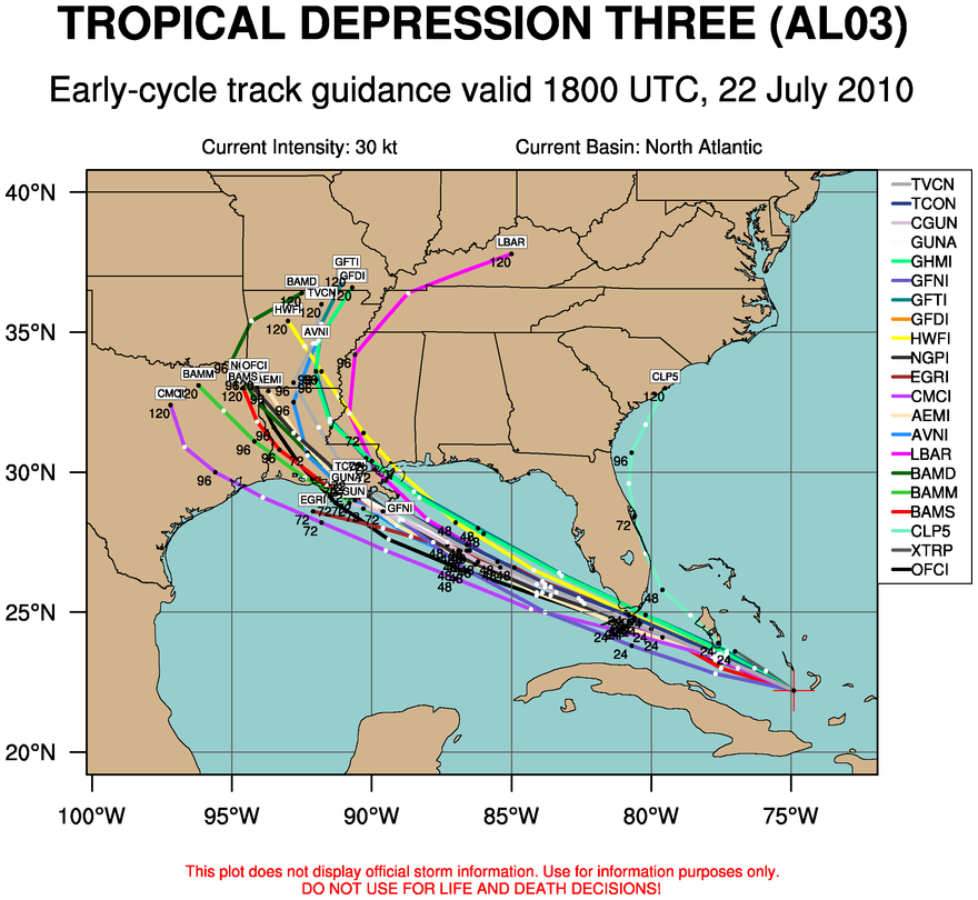 National Hurricane Center and the spaghetti chart (a compilation of various computer model forecast tracks - see right image). We'll have to keep a close eye on any intensification of this storm, especially when it exits the Florida Peninsula and heads into the Gulf.
 We topped out at 95 degrees today in Louisville, which was two degrees short of being the hottest day of the year so far. Higher dew points also stayed to our west today as well, so things were not as bad as they could have been. We've had 31 days this year with 90 degree temperatures or higher in town, and I'm sure we'll be able to break 40. Compare that with 13 last year.


