Showing posts with label drought. Show all posts

Sunday, December 2, 2012

12/2 - 4:15pm - A Needed Shot of Rain on the Way

A few brief showers scraped across northern portions of West Tennessee this morning as expected. The disturbance causing those morning showers has left behind some cloud cover across the region with peeks of sun here and there. More of the incredibly warm weather that we've seen for the past few days arrives tomorrow just in time for the Jackson Christmas Parade at 6:45pm. 75 still looks like a good bet for a high temperature during the afternoon as we start the workweek on Monday.

Much of the area is experiencing moderate drought conditions right now. Even though the growing season is pretty much over it is still important for rainfall to keep up so that we don't have an already-in-place drought come spring. The good news here is that we have a chance for a good soaking rain on Tuesday with over a half inch possible in most places. The front causing this rain will leave behind only slightly cooler temperatures in the 60's, which is still warmer than average for this time of year. The next round of rain on Friday and Saturday is the one to watch as it could bring much, much cooler weather to the area next weekend behind it.

Check out the video below from yesterday night's newscast on WBBJ for your full forecast!

Thursday, August 23, 2012

8/23 - 5pm - Tropics, Drought, Storms... Anything Else?

Computer model forecast tracks for Isaac
The big shakeup in the world of weather right now is the presence of Tropical Storm Isaac south of Puerto Rico. Much uncertainty still exists with where the storm will go but certainty of it making some sort of US landfall is growing. Current forecast data from multiple computer models has this storm going anywhere from the eastern Florida Peninsula to the Central Gulf over the coming days. The trend has been for these forecast tracks to shift westward over the past couple days and that means that those with interests along the Gulf Coast need to watch this storm extremely carefully. The fact that this storm may miss most of Hispanola and it's rough terrain means that we could have a stronger storm than previously expected by the time it reaches the Gulf. Once we get some better data tonight from a NOAA Gulfstream IV aircraft that is being dispatched to take measurements of the storm the model data and forecasts should improve a bit.

The 5pm EDT National Hurricane Center update on Isaac has again taken a more westerly track than before thanks to the latest model data. Their forecast has Isaac remaining a tropical storm until it clears the north side of Cuba on Monday and becomes a hurricane. This all depends on where the storm tracks because the less of Cuba and Hispanola it goes over, the more time over warm water it will have. Should the storm remain weak like it is now for a longer period, a more westerly track can be expected.


How 'bout the drought? Not much has changed from last week's drought monitor product for West Tennessee and North Mississippi. Much of West Tennessee is still suffering from a severe to exceptional drought, especially in areas near the Mississippi River and Kentucky border. The area of exceptional drought, the highest level possible, has contracted a bit since last week. Areas south of Benton County and east of Bolivar aren't faring as badly as the rest of West Tennessee, but it's worth noting that rain may be hard to come by over the next week. The worst of North Mississippi's drought is still confined to areas near Tunica and areas south of West Point don't have drought conditions at this time.


Speaking of rain, we're looking at just a small chance for some isolated showers and storms on Saturday afternoon in North Mississippi as an upper-level system moves toward us from the west. This will increase our moisture and instability a touch since winds will be turning more southerly at the surface. West Tennessee will be too far north for this storm chance unfortunately. Small storm chances will be in the forecast again as we head into the early part of the workweek, but uncertainly skyrockets after that because our weather will depend on where Isaac, by then likely a hurricane, will go. A more westerly landfall along the Gulf Coast would mean quite a bit of rain for the region while a more easterly landfall in Florida wouldn't affect us too much. This again is something we'll need to watch.

Tuesday, July 10, 2012

7/10 - 11:55pm - A Tale of Two TV Stations

Let's start with weather first, shall we? Today was hot in Louisville, much hotter than anticipated because dry air that made its way into the area allowed temperatures to rise quite a bit. We're talking about a high temperature that was 95 degrees today, which even though is very warm, it was still cooler than what we experienced during last week's massive heat wave. Tomorrow should be a little cooler as moister air moves in again from the south.


Daily rain chances will be ramping up Thursday in Louisville as a trough develops to the west of the Mississippi River. It's already been raining in West Tennessee a bit this week, but more is on the way through the weekend as this trough gets its act together and a warm front moves northward. The rain is still needed in West Tennessee as drought conditions persist throughout the region. This rain will keep temperatures down in both regions, which is good news after all the heat! Between this past morning and Sunday morning there could be over 6 inches of rainfall  in West Tennessee and North Mississippi according to the Hydrometeorological Prediction Center (HPC). Flash flooding issues may crop up in some of the heavier thunderstorms.


Now, to the two TV stations. The first TV station in question here is WBBJ-TV in Jackson, TN where I'll be at on Saturday and Sunday night doing weather. It's been nearly three months since I've been on air in West Tennessee so I'm happy to be coming back this weekend and next weekend too for the Saturday night shows! The second TV station in question is WAVE-TV in Louisville. Today I went in to meet with Kevin Harned and the gang at the station and came out a WAVE 3 Weather intern. This has been "in the works" for awhile but today it was made official and I'm extremely excited to be sharing this news! I'll be at WAVE a couple days a week until mid-August. My duties will be mostly web-based with social media, blogs, etc, but I'll also assist with any needed TV-related tasks. I'm so thankful to be able to intern at the station I grew up with and to work with such a great team of meteorologists!

Tuesday, October 19, 2010

10/19 - 5pm - MSU Forecast Video

We're in for a pleasant rest of the week once these showers and storms clear out of the area, although we do need the rain around here. Portions of Mississippi are in a Severe Drought according to the US Drought Monitor, but some alleviating rains could be on the way later this weekend. Check out the video below:

Tuesday, October 5, 2010

10/5 - 5pm - MSU Forecast Video

It's been very dry around North Mississippi and it will continue to be like that for at least another week or two as high pressure stays firmly in place across the Eastern half of the US. These cool, dry, and windy conditions are creating a fire risk, so take extra caution if you're putting on a bonfire or burning brush this week. Check out the video below:

Wednesday, October 1, 2008

10/1 - 7:15pm - Cool Temperatures, Then a Warm Up?

With the month of October now in full-swing, it's expected that we'll have temperatures in the 60's and 70's. That will be true for Thursday and Friday, but we will see the return of lower 80's by Sunday and through the middle of next week. I'm thinking this could be our last batch of 80 degree temperatures for the year, so enjoy it while you can. Not a drop of rain is in the forecast for the next week.

I'm off to Florida until next Wednesday, so no blog posts or site updates until then. See you later!

Tuesday, September 30, 2008

9/30 - 4pm - Now, Where Were We?

The HPC nailed the rain total estimates last night. They were calling for around .25" in Louisville and my rain gauge shows .21" from overnight. That's pretty close!

We're back to our old dry pattern again, this time with highs in the 60's and 70's. We'll be in the mid 60's tomorrow, upper 60's on Thursday, and then back into the 70's for the weekend. No rain chances until at least the middle of next week. On that note, there will be no blog posts or site updates from this Thursday until Wednesday of next week due to my fall vacation.

Monday, September 29, 2008

9/29 - 7pm - RAIN!!!

Was that title loud enough? We've got rain, actual rain, on the radar right now heading toward us! This system is still maturing, so its unknown how much rain we'll get exactly. Looking at guidance from the HPC suggests around a quarter of an inch. We'll still have drought problems even after this system comes through. The good part is that we'll end the streak of dry days over the past few weeks, helping some of the plants out that are still flowering. Not to mention the brown grass on everyone's lawn...

We should be dry tomorrow as this system exits late tonight. Temperatures will position themselves in the 60's and 70's over the next week with sunny skies to complement by Thursday.

Hurricane Kyle is history after hitting Nova Scotia. Subtropical Storm (no tropical characteristics) Laura has formed in the Atlantic, luckily with no consequence to land in the forecast track.

Sunday, September 28, 2008

9/28 - 5:30pm - A Beautiful Sunday Afternoon

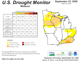
It's difficult to complain about our lack of rain when we've got comfortable temperatures and sunny skies. The fact of the matter is that we're in a moderate drought according to the US Drought Monitor:


We ventured out to Joe Huber Family Farm in Starlight, IN earlier this afternoon to pick apples and boy were they ripe! The nice weather attracted loads of people out to pick pumpkins and apples or simply relax and spend the afternoon shopping and eating.

Hurricane Kyle is barely hanging on as a hurricane right now, with winds at 75mph. It should make landfall in Nova Scotia as a strong tropical storm (technically an extratropical storm due to conversion to a cold-core storm) later tonight. All that's left for Maine right now is a Tropical Storm Warning.

There's still a small chance of rain for us Monday night into Tuesday, but the rest of the week looks dry. Tomorrow should be the last day in the 80's before we slide into the 70's and a few possible days in the 60's this week.

Friday, September 26, 2008

9/26 - 5pm - TS Kyle, Rain Chances Slim

The low pressure area we've been talking about that's northeast of the Bahamas has now been named Tropical Storm Kyle. Contrary to the model hype earlier in the week, Kyle will not hit New York City or any large populous areas in the Northeast. Its current track grazes the coast of Maine before heading north to Canada:


Kyle will reach hurricane status by this weekend, but probably won't affect much of anything due to its location. It will hit the east coast of Canada as a tropical storm, but it should quiet down pretty quickly after heading inland. Pending any major track variations in the next few days, this should be a pretty forgettable storm.

We should stay dry as usual until Tuesday, when a weak front coming through could generate some showers. Again, optimism is pretty low at this point, so I wouldn't bet on seeing rain on Tuesday. Highs should decrease into the 60's and 70's next week!

Wednesday, September 24, 2008

9/24 - 4pm - Rain.... Please!

On my way home today, I saw that a creek near my house had completely dried up. That gave me a pretty good perspective on how our weather is right now: DRY. We might get a spot of rain Friday with a storm coming onshore in the Carolinas, but that's a stretch at this point. Expect temperatures to spiral down to 80 degrees by Friday after another hot one tomorrow.

That developing area of low pressure near Puerto Rico I talked about yesterday is not as organized as previously expected. Most models are still bringing it up to New England, but now most have it as a tropical storm now instead of a hurricane. Personally, I think this storm will barely materialize due to the possible tropical depression in the Carolinas throwing clouds over the Atlantic. This could limit solar heating on the water and cause interference with the water temperatures needed for this to form. This might have happened to Hurricane Gustav when Tropical Storm Hanna's cloud cover started intermingling with some of Gustav's, which could have made water temperatures drop in a crucial area of development. In any case, we'll have to watch both of these systems into the weekend.

Monday, September 22, 2008

9/22 - 7:30pm - Welcome to Fall

Ah yes, 'tis the season of changing leaves, sweaters, football, and the occasional early snowstorm. Today was the first day of Fall 2008 and nobody could really tell. A continuation of our dry, nearly drought weather has made that Summer feeling in the air stick around a while longer. We're slated to be dry until possibly the first week of October according to the GFS. Even then it looks doubtful that we'll see much if any rain at all! At least our mornings and evenings in the lower 60's have made things feel a little more fall-ish.

An area of low pressure near Puerto Rico is making weather-watchers like myself cast a weary eye to the Caribbean. It is not yet a tropical depression, but it's getting fairly close according to the NHC. Some models were and still are taking this storm near the NYC area, prompting concern that this could be like a storm that hit New York on this day in 1938. Since it's late in the season and the water is not as warm in that vicinity comparted to the Gulf, I really wouldn't worry about this storm being a big mess like the one in '38. It is important that we keep an eye on it though in case it throws in some late season surprises.

Still 11,000 without power in Louisville as of 4:30pm today. It boggles my mind that we still have people without power from last Sunday's wind storm. That right there should tell you that this was a phenomenon that many of us will only see once in a lifetime. After returning to school today, an outpouring of many stories and experiences reverberated throughout the halls. I heard some say they didn't even lose power or see all that much wind. Those experiences were in the minority as most of the people I talked to said they were without power until this past weekend, with a few still without power. Many also had to clear out tree limbs and repair damage caused to their homes. We only lost a half dozen shingles and a couple limbs fell in our woods, so I consider myself lucky after hearing what others had to go through.

Thanks again for all the comments concerning my acceptance into MSU yesterday.

Sunday, July 27, 2008

7/27 - 12pm - Maybe I Went Too Low?

The models yesterday were all a mess when it came to temperatures. The GFS was building a huge heat wave in here for early this week, but the NAM was being more conservative. So, I went in the middle and said 93 would be the hottest we'd get, which would have been on Tuesday. Oops! Now the models have come into agreement, but it's the GFS that generally won out in the beginning. I think we could see temperatures up to 96 degrees on Tuesday, with lower 90's until Friday.

Now it's time to talk about the big elephant in the room... Rain. I said we could get some rain this weekend, and well, quite frankly we really didn't. All the isolated storms missed us for the most part and we're left high and dry. If we don't get anymore appreciable rain this month, we're in for a 2.5" inch deficit for July. While we're certainly not in a drought, a dry ground can only make the air warmer. Our next chance for rain will be on Wednesday, but my confidence level on us seeing some of that rain is quite low.

Friday, July 11, 2008

7/11 - 1pm - A Repeat of Yesterday

We're a little warmer than we were yesterday at this time, with the suburbs holding at 85 for the moment. Urban areas in town are in the upper 80's, with a high of around 90 expected by later this afternoon. Our next chance of rain looks to be tomorrow evening, when some scattered showers and thunderstorms. Sunday afternoon will have higher rain chances as a cold front sweeps through here from our west. A nice week is in store for next week as high pressure sets in a calms down our general weather pattern.

Here's an update on Hurricane Bertha's forecast track:


Looks like Bertha will only come close to Bermuda, but not actually hit it. Forecast accuracy is key here; any westward movement not factored into the forecast would put Bermuda in harm's way.

Our weather for the rest of the summer looks pretty uneventful. The CPC (Climate Prediction Center) has released the July-August-September climate outlook, and nothing is out of the ordinary for us. Here's the temperature chart:


We're in the EC (Equal Chances) area, meaning our temperatures won't really differ all that much from normal. The Northeast and the Southwest look really warm though, with above average temperatures forecast. The precipitation chart looks very similar for us as well, with Equal Chances covering much of the eastern half of the nation:


Notice though that the Northeast will see above normal precipitation, along with increased temperatures on the first map. It's interesting that an area in the southern tips of MS, AL, and GA will see increased precipitation. Hopefully that area can extend north a little and provide some relief to areas in North Georgia and the Carolinas, where water is needed pretty badly.

Thursday, October 25, 2007

10/25 - 8pm - Finished With Rain, Cool Temps Ahead

Our grand total for shortage of rain after our huge rain event over the last couple days is 1.94 inches below average. We were pushing 6 inches just before it. Its good we were able to just about flush our drought out of here before cooler temperatures come in. We'll only see a couple chances for some light showers before we head into a cooler, calmer weekend.

In the longer range, the GFS has us in line for some much cooler temperatures come a couple weeks from now. I think we'll be in the 40's a couple days with the balance of the week in the 50's. We're still iffy on some flurries some time during that period at night...

Tuesday, September 18, 2007

9/18 - 9:30pm - Why We Are Warming Up...

It was supposed to cool off this week and the next, but instead it looks like we will go for the 90's after Wednesday. This is all because it was expected to rain late last week, but never did. Without any moisture in the ground or in the air, the sun just bakes everything. Ho hum on the cool down...

No moisture in sight! NONE!!! Not one drop until at least next week, and doubtful at that! The only way to get some rain right now would be from a tropical system coming up north. As of now there is a disorganized mess of thunderstorms getting ready to transverse Florida from the east. The GFS has this thing being a tropical storm and hitting the TX/LA border coastline by this weekend. Other than that there are a couple slow meandering areas that can't get their act together. So you can pretty much throw our chance of tropical system rains out the window with the positioning and lack of intensity of the systems developing.

If we get a couple more weeks of these dry, hot conditions, it'll be a full blown desert here!

Monday, September 10, 2007

9/10 - 9pm - From Feast to Famine

Ahh... The half inch of rain that we received yesterday greened up the grass and perked up the plants. Now there's no more rain in sight, except for a small chance on Friday. I guess we're in a pattern that "when it rains it pours", yet when it isn't raining "its drier than the SAHARA!" It's interesting how we get big bursts of rain in between extended periods of drought conditions. I guess I can't say too much about this rain when temperatures this weekend will be in the MID-70's. Tomorrow's high: a bone-chilling (hey folks 105 feels normal to us now) 78 degrees.


Next order of business is a sticky situation in the tropics. Number 1 on the map above is slated to become a tropical depression by tomorrow or Wednesday. This looks like a larger area of coverage on this wave than a couple previous waves that turned into storms, so this storm could be a big one. The only thing I really know about it is that it will be called Humberto once it reaches tropical storm status. Landfall is still a mystery right now, but one thing's for sure: gas prices will go up if this thing even breathes on the US...

Sunday, September 2, 2007

9/2 - 11pm - Oh I Blew it on Felix

Yeah folks... Sorry about that one. I said on the forecast video that Hurricane Felix wouldn't get past a Cat 1 or 2. Now its a Category 5 storm near Jamaica (Cat 2 to 5 in less than 24hrs, holy smokes folks). Yesterday the projections didn't really get past a Cat 3 at maximum. Then I woke up to a Cat 4 monster this morning. That made me feel sheepish...

No matter, here's the current track:


I'm a little worried about that track right now. It plows Felix right through the Yucatan and emerges as a hurricane on the other side, in the Gulf of Mexico. The GFS is a mess as I said before so I can't use that for guidance. The rest of the models show a re-entry into Mexico after the Yucatan hit, but after that flare up and surprise overnight, I'm still skeptical. Otherwise, I'm not sure what to tell you until this storm clears the Yucatan.

As for here, It's really dry. I mowed the lawn today and created the most sizable dust cloud ever seen to man. Not to mention that it all got into my lungs. With ground that dry, its hard to negotiate a cool down in the air. The ground only makes heating worse, which makes drought conditions worsen, and then the circular pattern begins. We could see rain next weekend, but even then its hard pressed.

Wednesday, August 29, 2007

8/29 - 7:30pm - GFS is a Mess

Whew! Disregard that GFS for the next few days if you're hurricane hunting. As usual its flaunting specific storms, moving their landfall positions around wildly, and then not showing the storm altogether. This all happened in the period of one day. Nevertheless, the tropical waves that we need to watch out for are still in existence. A notable non-tropical low that kinda perked up today was one located off the coast of North Carolina. This low could turn tropical as it heads south into the Florida area. Since the shear (high-speed winds aloft) is very low in this Florida corridor, development into a tropical depression or storm is possible.

Of course there is still the tropical wave halfway out in the Atlantic that could bring something to the US in a week or so. This one has some moderate development conditions to work with, but again we're not talking about a wave as strong as the one Dean formed from. Again, just keep an eye out over the next two or three weeks.

Today was the final day in the 90's for a little while. We'll be basking in mid to upper 80's for a week or more, but we'll be pretty dry though. The best rain chance is tomorrow, and that's 30% at best. Gosh, it may be winter before we make some progress on clearing out this drought.

Tuesday, August 28, 2007

8/28 - 4pm - Parade of Hurricanes

I've been "out of the loop" for a few days to get some school stuff done. Just by lucky chance I decide to see the Atlantic GFS model this afternoon. HOLY COW!!!

Yeah, that's because we are going to see a massive increase in tropical activity. The current GFS has a hurricane hitting the Florida coast on September 13th, and many more storms in line behind it. The minute I saw the model I saw it proper to call this blog entry "Parade of Hurricanes". Here's what I mean:

If you look behind the Florida storm on the left, you'll see three purple blotches in the Atlantic. Those are Tropical Depressions/Storms that have potential to become hurricanes. The issue here is not whether we will see another hurricane. The issue is where the next one will landfall. It is too early to take this model without a grain of salt. Even though this model run shows four storms we may only get two or three and the timing could be off. I'm not yet predicting a Florida landfall because this model is 16 days out. I can't even tell you what I'm going to be doing in 16 days so I sure as heck can't tell you where a hurricane will go.

Do not be alarmed yet, I'm just issuing a tropical **watch** right now. That means to pay attention over the next two weeks because this tropical season could get real nasty, real quick. I wouldn't be surprised if we near some records this year for storm frequency and intensity, and based on this model I think we could easily do that.

On the home front, we're getting ready to cool off a bit. Tomorrow will be the last day in the 90's for at least a week. I think we can all collectively say "Hooray!" to that. We have a chance of storms on Thursday, but I'm hard pressed to see any significant rain anytime soon. Maybe one of these tropical systems gives us some rain soon!