
 My apologies for posting so late today. I didn't expect the recovery time from my wisdom teeth removal procedure this morning to last so long, but I think I'm about 95% back to normal now. Cold temperatures are the big story tonight as clouds continue to clear out of the area and cooler air filters in from the northwest. Low temperatures will hover around 8 degrees early tomorrow morning and we're already well into the teens at the eleven o'clock hour here in Louisville. Check out some of the surface observations on the image to the right. Indianapolis and Evansville, IN are coming in at 9 degrees at the moment with temperatures getting even closer to 0 as you make your way toward Peoria, IL. Wind chill values will get a few degrees below zero tonight, especially in the suburbs of Jefferson and surrounding counties.
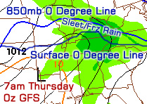
It's a real sticky situation as you can gather from my comments above. Since just a few miles will make a difference during this Wednesday/Thursday event, snow, sleet, and freezing rain amounts will vary wildly across Kentuckiana. I'll have an update tomorrow with more specifics and hopefully the computer models will have a better handle on this storm by then.
Check out some video that I shot of today's snow accumulations in Louisville below:
Be sure to select either 720p or 1080p and play at fullscreen for a high-definition experience.
No comments:
Post a Comment