Saturday, May 8, 2010

5/8 - 3pm CDT - Just Arrived in Amarillo, TX!

Hello from Amarillo, Texas! It's only 62 degrees right now, making my choice of travel attire (shorts and a t-shirt) seem a little off. Luckily, it will warm up here tomorrow as we drive out to start chasing.

This evening the arriving tour 2 group will meet for orientation. We'll go over the basics of storm chasing, safety precautions, and a few housekeeping items. After orientation we'll pile in our vehicles and head to our traditional first dinner of the tour at The Big Texan. This place is quite the tourist attraction, with signs in the airport and around town advertising their "Free 72 oz. Steak" (if eaten within one hour). I think I'll stay with my 8 oz. sirloin, thank you.

Now, on to more important things. We'll probably end up chasing tomorrow somewhere in Central or West Texas based on what the computer models are saying right now. No particular parameter looks very impressive, so we may not see any storms to write home about. We'll see what the situation looks like in the morning.

Monday is when the action cranks up. A severe weather outbreak has been forecast for Oklahoma, Southern Kansas, and North Texas for quite a few days now and things certainly aren't backing down now with the Storm Prediction Center issuing a 30% risk for severe weather for the region. The NAM and GFS computer models have CAPE values well over 3000 J/kg in Central Oklahoma, which is just phenomenal for supercell development. Bulk shear values are topping 70 kt and dewpoints will be in the upper 60's throughout the area, so neither of those are limiting factors. The NAM is also indicating EHI (Energy Helicity Index - combines helicity and instablity) values over 6 in West Central Oklahoma. Values over 5 are considered to be good indicators for strong EF4 and EF5 tornadoes, so there's much excitement in the storm chasing community right now over this outbreak. I do want to caution that a few storms that will be exiting Eastern Oklahoma and Kansas on Monday morning, which could contaminate the atmosphere a little bit and limit heating. Here's what the Storm Prediction Center has to say about that:

BANDS/CLUSTERS OF ELEVATED TSTMS ARE EXPECTED TO BE ONGOING EARLY MONDAY ACROSS PORTIONS OF ERN KS/OK OWING TO A ROBUST WAA REGIME WITHIN A BROAD 45-50 KT SSWLY LLJ.  THIS ACTIVITY MAY PROVE PROBLEMATIC FOR A NWD EXPANSION OF THE WARM SECTOR MONDAY AFTN AND THIS UNCERTAINTY WAS THE PRIMARY REASON FOR NOT UPGRADING TO A MDT RISK.

On a brighter note, they also had this to say about the good shear I mentioned earlier:

FCST HODOGRAPHS EXHIBIT STRONGLY VEERING LOW-LEVEL WINDS WITH THE COMPLETE VERTICAL PROFILE SIGNATURES INDICATIVE OF HISTORIC STRONG TORNADIC CASES.  VERY LARGE HAIL WILL ALSO BE POSSIBLE.

That's some pretty strong wording there coming from the SPC. I think we're going to have a wild day of chasing on Monday if things come together as anticipated.

Friday, May 7, 2010

5/7 - 4:30pm - Leaving for Storm Chasing Tomorrow!

I'm flying out to Amarillo, TX tomorrow morning to begin my month-long Plains storm chasing trip with Storm Chasing Adventure Tours. We'll start chasing on Sunday, but I think the real action could come on Monday when an outbreak of supercell thunderstorms could affect Central Oklahoma and Kansas. I'll be posting updates, pictures, and HD video clips from our chase right here on my blog until June 5th when I come back to Louisville. Don't forget that you can get up-to-the-minute updates from my trip by following me on Twitter or friending me on Facebook.

I made a visit to WAVE-TV today in Louisville to do an on-camera interview for a storm chasing news piece that will air on or around May 21st.

Meteorologist Kevin Harned (who interviewed me today) will be joining us on our chase from May 29th to June 5th. It's going to be great fun to have two guys from Louisville out there looking for tornadoes!


A strong line of thunderstorms will make it's way through the Louisville area tonight, bringing with it the possibility of damaging winds, hail, and maybe even a tornado. Even without the thunderstorms, a Wind Advisory is in effect until 8pm. There's a greater risk of severe weather tonight in Indiana and into Ohio with the possibility of tornadoes up that way (tornado risk probabilities from the SPC are posted to the left). From East Mississippi, to Louisville, and to the Great Plains, severe weather seems to follow me around!

I'll post here tomorrow when I get to Amarillo and I'll also post a few travel updates on Twitter and Facebook if you want to see where I am!

Thursday, May 6, 2010

5/6 - 3pm - Only One Day Left!

It's hard to believe that tomorrow is my last full day in Louisville before I leave for my storm chasing trip on Saturday morning. I'll be heading out to Amarillo, TX to start my month-long journey throughout the Plains in search of severe weather with Storm Chasing Adventure Tours. Remember, I'll be making daily blog posts with HD storm video, pictures, and chase reports. You can also follow me on Twitter or Facebook to get up-to-the-minute chase updates, meaning you'll be the first to know if we see a tornado!

We may be heading to West Texas on Sunday, our first day, to chase any supercells that form there, but conditions are looking ripe for a good-sized severe weather outbreak in Texas, Oklahoma, and Kansas on Monday, which will be our second day of chasing. Instability (CAPE) values approaching 3000 J/kg, bulk shear of over 60 kt, and dewpoints near 70 degrees will really get things going late Monday afternoon. My guess right now is that we'll probably position ourselves somewhere in Central Oklahoma in the morning and wait to see where the winds begin to turn from the east. Winds during the morning hours should be from the South and Southeast, but areas that begin to back to the east will have the most potential for tornadoes. We may end up anywhere from Kansas to North Central Texas depending on how conditions evolve. The Storm Prediction Center has already outlined the potential severe weather outbreak in their 4-8 day outlook.

Back home here in Louisville, there's a 15% risk of severe weather tomorrow. We may see some severe storms tomorrow evening as a cold front approaches the region, bringing with it the risk of hail, high wind, and possibly a tornado or two. The bigger risk of severe weather will be to our northeast in Ohio, where instability values, shear, and moisture will be higher. Definitely something to keep an eye on tomorrow, but I think it won't be near as bad around Kentuckiana tomorrow as some of the previous severe weather outbreaks we've seen over the past couple weeks around the Southeast.

Tuesday, May 4, 2010

5/5 - 12am - OH Valley Severe Weather, Storm Chasing

Things are beginning to take shape for an Ohio Valley severe weather outbreak on Friday. The Storm Prediction Center maintains a 30% risk for severe storms for us like they did yesterday. Right now it looks as if damaging winds will be the biggest risk, but a few tornadoes are certainly not out of the question. Instability and shear appear adequate for severe storms according to the NAM model, but moisture may be the limiting factor here. If dewpoints approach 70 and there's enough moisture throughout the atmosphere (not just at the surface) on Friday, then moisture won't be a problem. Right now, the GFS and NAM are having trouble getting them into the mid 60's.

Since I leave for my storm chasing trip on Saturday, I'm beginning to look carefully at the pattern that's evolving in Tornado Alley. Right now, it appears that we may have some storms to chase on Monday the 10th near the Oklahoma/Texas border, meaning we won't have too far! CAPE values (instability) of over 3000 J/kg and bulk shear of over 40 kt will really help to boost storm development. The next day may have some severe weather to the north of Sunday's initial target area, so I think we're getting ready to enter into a good storm chasing pattern after a relatively quiet start to the season.

Monday, May 3, 2010

5/3 - 3pm - Flooding, Late Week Severe Weather, Storm Chasing

The rain that caused massive flooding in Nashville and elsewhere around the Southeast is finally out of here. The pictures coming out of Nashville, where 13.53" of rain fell at the airport this weekend, are just incredible, including this shot of the now-evacuated Gaylord Opryland Hotel and Convention Center:

(Photo Credit: Erin Davison)

More flooding problems could be on the way for areas on Nashville on the Cumberland River as it crests this afternoon. The death toll from this weekend's storms and flooding across Tennessee, Kentucky, and Mississippi stands at 21.

As this weekend's weather event wraps up, we now turn to later this week in the Ohio Valley. The Storm Prediction Center put all of Kentucky, Indiana, Ohio, and West Virginia, along with parts of Michigan, Tennessee, Illinois, Missouri, and Pennsylvania in a 30% risk for severe weather on Friday:


Here's what the SPC is saying about this event on Friday:

IT STILL APPEARS THAT A STRONG WIND FIELD WILL OVERSPREAD A MOIST AND UNSTABLE WARM SECTOR IN PLACE OVER THE OH VALLEY INTO LOWER GREAT LAKES.  HERE...ENVIRONMENTAL PARAMETERS WILL BE QUITE OPTIMAL FOR SUPERCELLS AND/OR A LARGE-SCALE LINEAR CONVECTIVE SYSTEM WITH THE THREAT FOR WIDESPREAD SEVERE WEATHER.

The GFS model seems to support these assertions with ample shear and the presence of upper-level divergence on the 500mb chart (causes uplift in the atmosphere... crucial for storm development):

The NAM model will chime in on this event tomorrow, which means we will have a better handle on what kind of instability and winds we'll be dealing with. I will say that moisture will not be a limiting factor for severe weather on Friday as dewpoints will most likely be in the 60's. There could be a few severe storms around the area on Thursday and Thursday night as the cold front with this system approaches the area, but limited shear will keep a lid on that potential.

The ironic thing about this Friday severe weather is that I'm leaving for Amarillo the next day to start my storm chasing trip. The start of the tornado season in the Plains has been very slow because of limited Gulf moisture, but now that temperatures in the Gulf have risen, I think things will begin to pick up pretty quickly. This week will be fairly quiet due to a west-east zonal flow across the US, but next week a disturbance in California will bring back the much-needed southwest winds to the Plains. Here's what the GFS is putting out for May 10th (my second day of storm chasing) in terms of instability and moisture:

Notice how the CAPE (instability) goes well over 2000 J/kg on the TX/OK border in the image on the left and how dewpoints will be approaching the 70 degree mark in the image on the right. These two factors are very good for severe weather in both TX and OK, so our Todd (our tour leader at Storm Chasing Adventure Tours) and I are really going to have to watch the development of this situation as next week approaches. Storm Chasing Adventure Tours started the first tour of the season yesterday by driving from Amarillo, TX to Meridian, MS to see some severe storms around South Mississippi. Even though the zonal flow this week won't be conducive for any widespread severe weather, I'm sure it'll be a fun tour. I'll be out there on Tours 2-5 (May 8th - June 5th), so don't forget to check out the blog for videos, pictures, and updates!

Sunday, May 2, 2010

5/2 - 3:15pm - Storm Chasing & Too Much Rain!

In exactly one week from today, I'll be on the road with Storm Chasing Adventure Tours looking for supercell thunderstorms in the Plains! After a busy week of packing and preparation, I will leave for Amarillo, TX on Saturday to meet up with the group. Right now the pattern is not indicating any type of severe weather outbreak in the Plains over the next couple weeks, but there may be some isolated activity that could produce a tornado or two. Since I'm going to be out there from May 8th to June 5th (a full month!), there will be plenty of time for conditions to change and possibly generate some good tornado outbreaks. Don't forget that I'll be posting HD video, pictures, and chase reports right here on the blog. We will begin streaming LIVE video when I begin chasing next Sunday on Storm Chaser TV. The excitement begins soon!

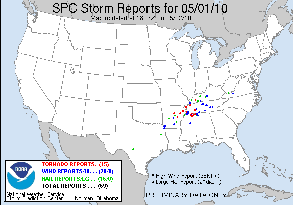
Turbulent weather has been prevalent across the Southeast over the past 24 hours. Last night featured quite a few supercells in Arkansas and a strong one that grazed the Memphis area, causing the evacuation of the Beale Street Music Festival. There were 15 reports of tornadoes in North Mississippi, West Tennessee, Arkansas, and even one in West Kentucky yesterday. Two more tornado reports came in this morning from South Central Kentucky as well. Flooding was an even bigger issue yesterday and still today as well throughout Central Tennessee. Southwestern sections of the Nashville area have received over 11 inches of rain over the past 24 hours according to the National Weather Service:


Parts of I-24 and I-40 around Nashville are closed due to flooding and 6 people were killed as flood waters rose last night. Heavy rain is still falling in Nashville at this time and won't end completely until early tomorrow morning.

Over 2" of rain has fallen in Louisville this morning, with some areas in the Metro getting over 4" of rain already. My rain gauge here in Southeast Louisville is indicating 2.27" of rain since midnight and 3.69" for the whole rain event since yesterday. Needless to say, flood waters are rising around town and we're under a Flood Watch until 5:30pm. Some roads in the South end of town, where the most rain has fallen, are under water. Be careful and don't drive into flood waters if you're traveling around Louisville today!

Saturday, May 1, 2010

5/1 - 11am - Kentucky Derby & Severe Weather?

It's the first Saturday in May and we all know what that means in Louisville: The Kentucky Derby! The rain is still falling here, but I think we may catch a break around lunchtime and the sun may even come out. We'll see more rain after that brief clearing, but the latest RUC computer model runs are indicating another break in the rain around 6pm, when the Derby will run.

Severe weather has been a big issue to our southwest over the past 24 hours, but the Louisville area may see a few severe storms this afternoon and evening, especially if the sun comes out after the rain breaks this afternoon. Heavy rain will be making its way back into the region tonight, when we could have some flooding problems in the Ohio Valley. To the right is the expected rainfall estimate for today and tomorrow from the Hydrometeorological Prediction Center, which shows Louisville getting over 6" of rain.

A rare High Risk of severe weather has been issued for parts of Arkansas, Mississippi, and Tennessee today due to the threat of strong, long-tracked tornadoes. This is the third time in a week that a High Risk has been issued by the Storm Prediction Center. Tornado watches have been issued for these areas, including the region around Mississippi State University. This comes after last night's severe weather troubles in Arkansas, where tornadoes damaged homes and caused at least one fatality. Big time flooding is occurring in Memphis right now, with more rain on the way this afternoon and evening.

With all of this severe weather going on I nearly forgot that we are exactly one week away from the start of my month-long storm chasing trip! I'll be leaving Louisville on May 8th to go storm chasing with Storm Chasing Adventure Tours. Don't miss my blog posts and updates from May 8th to June 5th!