In exactly one week from today, I'll be on the road with Storm Chasing Adventure Tours looking for supercell thunderstorms in the Plains! After a busy week of packing and preparation, I will leave for Amarillo, TX on Saturday to meet up with the group. Right now the pattern is not indicating any type of severe weather outbreak in the Plains over the next couple weeks, but there may be some isolated activity that could produce a tornado or two. Since I'm going to be out there from May 8th to June 5th (a full month!), there will be plenty of time for conditions to change and possibly generate some good tornado outbreaks. Don't forget that I'll be posting HD video, pictures, and chase reports right here on the blog. We will begin streaming LIVE video when I begin chasing next Sunday on Storm Chaser TV. The excitement begins soon!
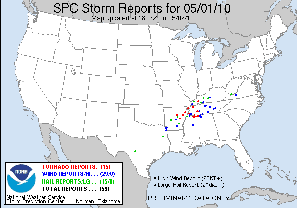
Turbulent weather has been prevalent across the Southeast over the past 24 hours. Last night featured quite a few supercells in Arkansas and a strong one that grazed the Memphis area, causing the evacuation of the Beale Street Music Festival. There were 15 reports of tornadoes in North Mississippi, West Tennessee, Arkansas, and even one in West Kentucky yesterday. Two more tornado reports came in this morning from South Central Kentucky as well. Flooding was an even bigger issue yesterday and still today as well throughout Central Tennessee. Southwestern sections of the Nashville area have received over 11 inches of rain over the past 24 hours according to the National Weather Service:
Parts of I-24 and I-40 around Nashville are closed due to flooding and 6 people were killed as flood waters rose last night. Heavy rain is still falling in Nashville at this time and won't end completely until early tomorrow morning.
Over 2" of rain has fallen in Louisville this morning, with some areas in the Metro getting over 4" of rain already. My rain gauge here in Southeast Louisville is indicating 2.27" of rain since midnight and 3.69" for the whole rain event since yesterday. Needless to say, flood waters are rising around town and we're under a Flood Watch until 5:30pm. Some roads in the South end of town, where the most rain has fallen, are under water. Be careful and don't drive into flood waters if you're traveling around Louisville today!
Just about everyone I talked to today had an opinion on all the rain that we've had. Luckily we're almost to the end of this cycle of rain, but we have one more hurdle to go through tomorrow.
Storms should form ahead of a cold front that will pass through the area early tomorrow afternoon. Some of these could be strong to severe, but the brunt of any severe weather would most likely occur to our south where instability will likely be stronger. In any case, this won't be a big outbreak, but rather a risk for isolated severe storms and some supercells unless a factor like directional shear, instability, or frontal passage timing changes. The main things to look out for tomorrow are high wind gusts, heavy rain, and possibly some large hail.
Here's the latest outlook from the SPC:
They've put us in a 5% risk for severe weather, but some of the area may be upgraded to a SLIGHT Risk (15%) tomorrow morning once the situation becomes clearer.
We started off in Northern Oklahoma this morning where there were east winds, but the cap (warm layer of air above the surface) was on too tight and was inhibiting convection. After hours of meandering through the area near Woodward, OK, we finally saw some cumulus clouds getting organized just south of Wichita, KS. We hopped on I-35 toward Wichita and caught up with a cell that was just giving birth to a wall cloud as we arrived. We stayed with this supercell for nearly three hours because it was a training storm, meaning it kept reforming and staying in the same location. It had a rotating wall cloud for a good portion of its life, but no funnel or tornado ever manifested. Frequent cloud-to-ground lightning provided a good show for us until another storm cell finally formed and pushed the weakening supercell out of the area.
Looks like our target area tomorrow will be somewhere near Central or Eastern Nebraska, but we'll know for sure tomorrow morning.
NOTE: There will not be anymore live streaming video and fewer blog updates for the rest of my trip because our rental vehicle cannot be outfitted with custom mobile broadband and networking equipment. You can still see our current location at http://stormchasertv.com.
The last 36 hours have been very eventful, but we still got to go chasing today! Todd came and picked us up in Wray, CO this afternoon after accompanying the tow truck carrying his deer-stricken SUV to Denver. We went to Western Nebraska and then down to Northwest Kansas after east winds began to develop there. The dryline helped fire off a few supercells and we chased those well into the evening. There were a few small finger-like funnels, but that was about it for the tornadic aspect of these cells. They showed very healthy rotation and dropped some nice wall clouds, but in the end the area was too cluttered with cloud debris and other cells in the region for any tornadoes.
As the sun set, we were able to position to the southwest of a supercell near Colby, KS and watch the beautiful colors reflect off the cloud towers with frequent lightning as well. The lightning show during the evening only lasted a few minutes before this cluster of cells dissipated.
Here's what we saw today:
Our new chase vehicle is a Chrysler Town & Country. We still have wireless broadband web and a laptop, but there's no way to get the custom antennas and networking equipment for the high-speed connection on this van (needed for video and my blog updates) because it's a rental.
Our target area will be somewhere between Eastern Colorado and Western Kansas tomorrow. I'm still able to post on Twitter and Facebook from my cell phone every few hours, so you'll still be able to follow us for the most part.
We've said goodbye to Storm Chasing Adventure Tours tour 6 and now tour 7 is in full swing! There are 6 of us now and we're ready to head out tomorrow morning on our first day of chasing. Latest indications are pointing toward a target area in NE Colorado, the Nebraska panhandle, and maybe even West Kansas due to an area of low pressure hovering in Colorado. Since we've had a great deal of success with this setup for the past few days, I'm willing to bet that we'll see some good supercells tomorrow.
Here's some irony for you: there was a supercell just northeast of Denver a few hours ago that produced a photographically confirmed funnel cloud. A similar incident happened last week on Sunday when we left to chase storms in Kansas and a tornado touched down just minutes from our hotel back in Denver. Even though we couldn't chase today's storm just a few counties away because we were changing out tour groups, the upcoming week looks great for at least the first few days.
After chasing a supercell through Southeast Colorado, we're done chasing today. There weren't any funnel clouds or tornadoes, but we saw a well-defined wall cloud. As the sun set, we drove under a gas station and let it pass over us. The storm came quick, which didn't give me and a member of our group named Charley time to get inside the car before the ping-pong ball size hail came. We both ended up squatting behind the chase vehicle because the wind was blowing hail and heavy rain under the overhang of the gas station. Things settled down after a few minutes and we got back in the SUV soaked. It was great fun! We're now heading back to base in Denver.
Tomorrow is the end of tour 6 and the beginning of tour 7 for Storm Chasing Adventure Tours. We'll say goodbye to Stephen, Charley, and Dave and welcome four new guests tomorrow as they arrive. Active storm chasing will resume on Sunday, but until then, we'll be running errands and getting ready for next week.
We're heading south from La Junta, CO to intercept some storms that will fire shortly. Shear, instability (don't need much with upslope flow), and moisture look OK, but everything else looks pretty tame this morning. In any case, we'll see what forms and chase what we can today. I'm not really expecting anything impressive, but things can change quickly out here. I'll post later if things improve or if we find a good storm.
If you haven't seen the video and pictures in the post below, I highly suggest you do so. We saw an amazing pair of supercells merge in Eastern Colorado yesterday, but they just stopped short of putting down a tornado. I was able to get up-close video of Sean Casey's TIV II (Tornado Intercept Vehicle II) from Discovery Channel's Storm Chasers and a brief rope funnel as well.
Choosing a target area today was hard, really hard. A cloud shield from Texas was prohibiting clean formation of supercells in SE Kansas, Texas itself couldn't support individual cells, and the Oklahoma panhandle turned out to be a letdown. We thought SE Kansas would be the target area if that cloud shield could hold off, but it didn't at all. So we turned around and headed toward SW Kansas and Oklahoma because of clearing skies and increasing cumulus clouds. While individual cells fired nicely at first with the interaction of the dryline, they eventually clumped together and didn't strengthen as expected.
The exciting escape part came as we wanted to go north to see if these cells would strengthen a bit. A mesoscale discussion from the SPC suddenly came out saying that rapid strengthening would occur as the storms hit an area of high instability. Sure enough, CAPE values were over 1000 J/KG near Liberal, KS and these cells turned into a single wind-driven monster in less than 20 minutes. We were looking for the updraft base when this happened, so we became trapped when this storm accelerated eastward towards us. Hail parameters on radar were reading over three inches, which made for a tense escape situation. The road network near Liberal, KS wasn't that great, making the search for an exit route very difficult. We were able to outrun the storm system long enough for it to weaken to a safe point. Taking shelter under a gas station in Meade, KS, we let the dying storm pass over. Only pea-sized hail and heavy rain happened in our area, so we did pretty well!
There was an unconfirmed report of a tornado inside this storm, but that may have been caused by one of the scary-looking fingers of scud cloud underneath the storm. This storm had intense straight-line winds and no rotation at this point, so it's unlikely a tornado was present.
Here are a few pictures:
We're most likely going to end up in Eastern Colorado tomorrow to catch some early-firing upslope storms.
I understand that there is some rough weather back home in Louisville tonight... stay safe out there!
After I posted my video in the blog post below on YouTube last night, I received an email from a producer at ABC's Good Morning America requesting permission to air a clip from it. It aired this morning during the first segment:
Today's target area looks like it'll be in Kansas or Oklahoma again, but possibly a bit further east. I'll be sure to update you when I find out.
This morning's target area of somewhere south of Wichita, KS quickly changed to west of Wichita once storms fired this afternoon. All storms to the south and east of Wichita became conjoined and had problems getting too severe because there was no east wind to fuel much rotation. Then there was a cell near Dodge City, KS that managed to keep itself separated and started moving to the right (that's a good thing!). As we approached Greensburg, KS, which was destroyed during a tornado in May 2007, it took on a classic flat updraft base and dropped a downright scary wall cloud.
The area just west of Greensburg was crawling with VORTEX2 vehicles, The Weather Channel, and other media trucks. We saw a bit of a dust cloud swirling on the ground under the storm, but we assumed it was a bit of inflow. It turns out that this could have been a tornado without the condensation funnel according to VORTEX2 reports. We chased the cell through its phases until it dissipated. This cell was very close to spawning a tornado, but we think cold outflow air from storms to the east contaminated the updraft base before it could do so. Here's a video of the cell from when we intercepted it to when it dissipated:
Here are a few photos:
A DOW (Doppler On Wheels) from VORTEX2.
The Weather Channel was broadcasting live during this storm and we saw some post-storm broadcasting going on next to this MSNBC SUV (NBC now owns The Weather Channel).
Tomorrow's target area will be in Kansas like today, so we really don't have to drive far! Time for some much needed sleep...
We're in Kiowa County, KS (near Greensburg) getting ready to intercept a very promising supercell. We're streaming live video at http://stormchasertv.com
Vortex2 is in the area, so we'll look for them. As always, I'll be updating on Twitter and Facebook.
As we drove south to Texas this morning we decided to stop off at the National Weather Center at the University of Oklahoma:
This shiny new building on OU's campus is home to the National Severe Storms Laboratory, the Storm Prediction Center, and other branches of NOAA. We couldn't get past the first floor without a formal tour appointment, so we just looked at some of the tornado probes and other items they had on display.
We got south of Wichita Falls, TX and found four storm cells in their infancy at around 3pm CDT. After an hour of formation, we chose the most westerly cell. Boy was that a good choice:
This storm had good enough rotation on radar to produce a tornado, but it just stopped short of dropping a funnel. Here's a video of the storm at its height, notice the inflow winds:
After this cell weakened and merged with a couple other cells, it started to take on great deal of dust with inflow winds. As the storm began to become outflow dominant, all that dust flew out of the storm in one big burst and created a bit of a dust storm:
As the storm once again strengthened, it presented another picturesque updraft base over a field of wind turbines:
This storm then raced to Abilene, TX where we met up with it after nightfall. It was a dying storm by then so we decided to core-punch it and shoot north to see some lightning. The storm unexpectedly strengthened and even started throwing out signs of rotation and notching along the southern edge as we headed into the center of the storm. Not to mention hail of 3"+ in diameter possible inside the hail core. These things plus some very intense rain made Todd change his mind and we abruptly turned around to find shelter. We found a gas station in Tye, TX and camped out under the overhang for a few minutes. While there, we experienced torrential downpours, frequent lightning, and strong winds. A transformer near the gas station blew in a fury of sparks and blue-green flashes after a few minutes of this intense weather. Needless to say, customers inside the convenience store were surprised by the sudden power outage.
How do you end an action-packed day like that? Pizza Hut!
It looks like we'll be traveling to Northern Oklahoma or Southern Kansas tomorrow. The SPC has just issued a MODERATE Risk for Central Kansas tomorrow, but we'll take a look at the data after breakfast in the morning. Here's hoping for another exciting day!
We're southwest of Wichita Falls, TX getting ready to choose a developing storm cell to intercept. Our LIVE streaming video and current location have just been activated for the day, so you can follow along with us at http://stormchasertv.com.
Things don't look too promising for tornadoes at the moment, but large hail and nice cloud structure are a sure bet. I'll be posting updates on Twitter and Facebook, so keep checking back!
Spring Break starts tomorrow afternoon for all JCPS schools and many other districts. I'll be gone this weekend and next week, so no forecast video or blog updates until next Monday (4/6).
If you're staying in town, you're in for quite a rocky ride weather-wise. Storms will start tomorrow afternoon with a high near 62 after a nice start to the day. Periods of rain and storms will continue through Friday night and into Saturday. With moist air and instability present on Saturday, multiple lines of severe thunderstorms and super cells are possible throughout the afternoon and into Saturday evening. I think hail and wind will be the main threat, but tornadoes are certainly possible due to decent shear profiles, along with the instability and cold front behind all of this mess. The latest SPC outlook has us in a 30% area (SLIGHT Risk) for severe weather:
The SPC mentions that they will be upgrading some of that 30% area to a MODERATE Risk tomorrow, so I'll post that information when I get home after school. I'm thinking this outbreak will be worst to our south in Tennessee and northern Georgia and Alabama, but if the associated area of low pressure shifts northward and westward, temperatures would bump up here and the supply of moist air from the Gulf would intensify a bit. If the low shifts eastward/southward, then our severe risk would decrease. We'll have to see what happens.
In any case, we'll top out at 67 on Saturday and then drop to 50 for Sunday after the cold front comes through, but luckily we'll recover to 65 by Monday. The next chance of rain will occur on Tuesday, with a high near 60. We'll end the week in the 60's it looks like, with a chance for rain or storms on Thursday night.
We're just outside the MODERATE Risk area for severe storms. Our tornado chances from the SPC have risen to 5% from 2% earlier this morning.
This all should transpire this afternoon as a broken line of thunderstorms comes through. The interesting part is that shear is actually pretty good, so we could actually see a couple supercells ahead or mixed in with the main line of storms. The main threats today appear to be hail and wind, but there is a threat for isolated tornadoes. With that in mind, keep your weather radios armed this afternoon. Instability is pretty marginal, but shear coupled with forcing should make up for that. If the sun comes out today, then this threat will increase due to higher instability.
Here's what's on the radar right now:
Notice how this line is forming into broken cells as opposed to a unified line. There are three Tornado Warnings out in Southern Missouri with these storms, pretty much where the line is breaking into individual cells.
Something I wanted to wait and check on when things got closer to Saturday was the possibility of some storms in the area today and tomorrow morning. It looks like this could be a deal-breaker for severe weather. We're going to get some storms this afternoon and maybe even tomorrow morning as well. Having storms this close to a severe weather event throws a wrench into the whole process because the atmosphere gets turned over, meaning the air at the surface is cooler than aloft. The question is, can the atmosphere recover and reverse this before tomorrow afternoon? I doubt it can do this completely.
Taking this into play, we're going to see multiple lines of storms come through tomorrow. Our primary threat is heavy rain and high wind. The SPC says there is a possibility for some super cells, but I'm not going to put all my cards in that pile. I don't think there will be quite enough shear to make a great deal of super cells, but a couple are certainly possible. Instability is about where it was in yesterday's blog post, so no big problems there (although it would be better if the CAPE was in the 3000 J/KG range, but the morning storms will not make that possible). I think we're just about out of the woods from a tornado threat due to some of these limitations, but one or two around the region are not out of the question if we do get a few super cells. Overall, this is just a normal early Summer severe weather event for Kentuckiana.
For today, we'll see a small chance for some afternoon thunderstorms and a high around 90. I sound like a broken record because the forecast has been like this for just about every day in the past week!
I just got some numbers in on instability for Saturday's hyped-up severe weather outbreak. Even though they're preliminary at this point, I'm already a little concerned. CAPE values (measures instability) are forecast to get near the 2000 J/KG mark, which is pretty unstable. Anything over 1000-1500 J/KG is high enough to support a severe weather outbreak, just as long as all the other elements come into place. The cap (layer of warm air just above the surface that acts as a "pressure cooker" to build up energy) looks like it will be around here until after noon on Saturday before completely getting blown off. This will allow sunlight to heat the surface and energy to build throughout the morning. During the afternoon when the cap disappears, this energy will allow air to rapidly lift upward (instability) and condense at high altitudes. The condensation of this air is what will form our severe storms.
We'll also have to see what happens with shear and surface winds as well on Saturday. I think shear will be adequate for an outbreak, but winds are still a question at the surface. Those will pretty much determine if we'll see a line of storms or separate super cells.
My best guess is that we'll see our standard setup: a few super cells in front of a MCS (mesoscale convective system) line of storms. It just doesn't seem likely that we'd have a tornado mess since we're pushing into July. Stranger things have happened though. Nobody, not even the SPC, can really tell you exactly what's going to happen until just hours before the outbreak. It's simply too far out to tell right now.
Until the rabble-rousing on Saturday, we'll see a small daily chance of thunderstorms and temperatures holding around 90. South winds will bring up moist air and push our humidity up quite a bit, with dew points in the mid to upper 60's (uncomfortable).
Before I go into today's mess, here's some pictures of the Twister Museum from yesterday:
The original Dorothy I probe from Twister (pretty good looking prop!).
We also visited the Salt Plains National Wildlife Refuge in Oklahoma as well:
Now, today looks like the best day all week (two weeks maybe). The SPC has issued a HIGH risk for severe weather in a vast area in the Plains. We're headed to the Nebraska-Kansas border in search of the highest possibility of storms. The cells (when they form) will move very fast, so we'll have to really be on our toes when chasing them. They'll also form later in the day, say after 5pm or so. I can't be sure that we'll see a tornado, but I think we'll at least see some impressive super cells.
You can track our position later this afternoon at:
We're not terribly sure where our target area is today. The computer models are showing a large low pressure system in Central Kansas that will tighten up and sink into Southwest Kansas by later this afternoon. That would mean our target area is somewhere in Southwest Kansas. There's also a school of thought that the SPC favors that would put our target area in Southeast Kansas. So we're making a compromise... we're going to South Kansas and waiting. Hopefully we'll figure out where to go later this afternoon.
It would be great if we could go 3 for 3 in the days that we've seen super cells. We've yet to see a tornado, but the cells we've seen are even better than seeing a tornado in some cases. You can't go into a trip like this with the mindset that you'll see a tornado. Just seeing some of the storm structure is worth the whole trip!
Here are some pictures of the super cell that John Belski mentioned on his blog this afternoon:
We chased it from Eastern Colorado into Western Kansas where it died out due to interference from surrounding clouds and cooler air seeping into the surface levels, which killed any instability the atmosphere had. We got hit with pea sized hail during the beginning, but according to spotters, this cell had up to grapefruit sized hail in its later stages. Thank goodness we didn't get hit with that!
Since today's severe potential is pretty much wiped out, we're on our way to WaKeeney, KS. We'll settle in to our hotel there and watch tonight's lightning show that is expected as a cold front sags south into the area.


 Turbulent weather has been prevalent across the Southeast over the past 24 hours. Last night featured quite a few supercells in Arkansas and a strong one that grazed the Memphis area, causing the evacuation of the Beale Street Music Festival. There were 15 reports of tornadoes in North Mississippi, West Tennessee, Arkansas, and even one in West Kentucky yesterday. Two more tornado reports came in this morning from South Central Kentucky as well. Flooding was an even bigger issue yesterday and still today as well throughout Central Tennessee. Southwestern sections of the Nashville area have received over 11 inches of rain over the past 24 hours according to the National Weather Service:


