It seems we received some of the worst ice accumulations in Kentuckiana here at my house in Southeast Louisville. Check out this slideshow for some pictures of the impressive ice accumulations that I took earlier this afternoon:
It took 30 minutes to get a minivan out of our driveway using sand. Trying to walk on any of this ice isn't a good idea. Glad that I only fell once! It should be noted that all the major roads in Louisville are pretty good right now, but those streets that have not been treated are extremely dangerous. Use caution if you have to be out today.
I'll be heading out to on vacation to Florida tomorrow so there won't be any blog posts for about a week. I should be back just before Christmas, so I'll be sure to post if any wintry weather heads toward Louisville after that point. It appears that things will quiet down for a short while, so it's certainly a good time to take a break!

Thursday, December 16, 2010
12/16 - 11:30am - Ice Accumulation Numbers
The temperature in Louisville got up to 32 at around 8am this morning, but we're now back down to 29 degrees. That's not good news at all because the accumulated ice simply won't melt with temperatures below freezing and cloud cover. Overall, Louisville did get around 0.5" of ice in places as expected, but the expected 1-2" of snow simply did not happen due to warm air advection aloft that traveled north quicker than expected. Here are some of the ice accumulation totals from the NWS in Louisville:
I'll post some more photos of the ice later on today. Some of those icicles out there are pretty big! I think Louisville will stay dry for the rest of the day but areas near Lexington will receive just a little more freezing rain.
...ICE ACCUMULATIONS FROM OVERNIGHT AND EARLY THIS MORNING THROUGH 9 AM EST...

THE TOTALS BELOW ARE SEPARATED BY AMOUNT AND ARE NOT NECESSARILY
THE FINAL AMOUNT FOR EACH LOCATION.

*************************ICE ACCUMULATIONS**********************

ACCUM  LOCATION             ST   COUNTY               TIME
-----  --------             --   ------               ----

0.5"   VALLEY STATION       KY  JEFFERSON           500 AM EST
0.5"   ENGLISH              IN  CRAWFORD            900 AM EST
0.3"   BROWNSVILLE          KY  EDMONSON            200 AM EST
0.3"   CASEY                KY  BUTLER              200 AM EST
0.3"   TELL CITY            IN  PERRY               900 AM EST
0.3"   ANCHORAGE            KY  JEFFERSON           900 AM EST
0.3"   DOE VALLEY           KY  MEADE               900 AM EST
0.25"  HOLLAND              IN  DUBOIS              600 AM EST
0.25"  FRANKFORT            KY  FRANKLIN            645 AM EST
0.25"  GEORGETOWN           KY  SCOTT               730 AM EST
0.25"  ELIZABETHTOWN        KY  HARDIN              745 AM EST
0.25"  CORYDON              IN  HARRISON            705 AM EST
0.25"  SALEM                IN  WASHINGTON          600 AM EST
0.2"   NWS LOUISVILLE       KY  JEFFERSON           900 AM EST
0.2"   FERDINAND            IN  DUBOIS              530 AM EST
0.2"   PORTERSVILLE         IN  DUBOIS              530 AM EST
0.1    LEITCHFIELD          KY  GRAYSON             715 AM EST
0.1"   BOWLING GREEN        KY  WARREN                MIDNIGHT
I'll post some more photos of the ice later on today. Some of those icicles out there are pretty big! I think Louisville will stay dry for the rest of the day but areas near Lexington will receive just a little more freezing rain.
Wednesday, December 15, 2010
12/15 - 11:40pm - More Ice in Louisville?
Jefferson County Public Schools are closed today (Thursday) due to the ice accumulations overnight. Great decision given the dangerously slick roads and driveways in Louisville. I know I have a few readers who go to my Alma mater duPont Manual High School, so you guys have the day off. Enjoy and be safe!
 The temperature is now up to 28 °F in Louisville as warmer air drives northward. Still think we'll be below freezing for the next few hours. I just snapped a picture of some icicles forming on our deck railing at my house... check it out. Took another walk around my driveway as well and found that ice skates were preferable to tennis shoes. Don't go out if you don't absolutely have to for the next few hours.
 the morning commute in Louisville. Still some snow falling to our north and east, but it's transitioning to sleet/freezing rain as warmer temperatures aloft work their way northward. I still think we're on track to get somewhere near 0.5" of accumulated ice here in the Metro, especially since radar returns are filling in to our west.
 We started out with some snow in the Louisville area around 10pm this evening, but most of Jefferson County has now switched over to freezing rain and sleet. With what I'm seeing on radar and surface observations, the heavy snow will still fall in areas just northeast of Louisville as you go toward Cincinnati. The heavy ice accumulations are going to happen right here in Louisville I think, up to a half inch or more in places. Areas near Springhurst and Prospect in Northeast Jefferson County may pick up some of that heavier snow, but most of Louisville will stick with freezing rain and sleet overnight unless temperatures above the surface cool a bit. I'll continue to monitor the trends, but as of right now I think Louisville and points south aren't going to see any more snow tonight except for a few snowflakes.
 No word on school cancellations in Louisville yet (JCPS says they'll make a decision at 4am), but I'm already seeing reports of slick roads in the suburbs. It's 25 degrees here at my house and 27 at the airport, so the liquid rain that's falling from the sky is freezing on the surface. Needless to say, things are going to be very slick on those untreated roads in the Metro tomorrow if temperatures continue to stay below 32 at the surface with freezing rain tonight.
***2:30am UPDATE***

***1:45am UPDATE***
My driveway (and most sidewalks/untreated streets in Louisville) is a sheet of ice and we're still awaiting another big batch of freezing rain in Louisville. That precipitation should be here within minutes and we'll continue to see freezing rain fall until around 7am or just before. Temperature at my house is 26.7 °F and the airport is still holding at 27 °F. You have to go down to Bowling Green, KY to find temperatures just above freezing, so I don't think any relief in the form of warmer air will make it here in time to spare  the morning commute in Louisville. Still some snow falling to our north and east, but it's transitioning to sleet/freezing rain as warmer temperatures aloft work their way northward. I still think we're on track to get somewhere near 0.5" of accumulated ice here in the Metro, especially since radar returns are filling in to our west.
 No word on school cancellations in Louisville yet (JCPS says they'll make a decision at 4am), but I'm already seeing reports of slick roads in the suburbs. It's 25 degrees here at my house and 27 at the airport, so the liquid rain that's falling from the sky is freezing on the surface. Needless to say, things are going to be very slick on those untreated roads in the Metro tomorrow if temperatures continue to stay below 32 at the surface with freezing rain tonight.
12/15 - 9pm - Snow/Sleet Initiating, Winter Storm on Track
***10:15pm Update***
Snow and sleet are falling simultaneously at my house in SE Louisville near Fisherville with reports of snow/sleet/freezing rain coming in all over Kentuckiana.Helpful Tip: It's sometimes hard to tell what type of frozen precipitation is falling because it's dark outside. If you're having a hard time trying to determine what's falling, stick a flat object like a tupperware lid, book, magazine, or pan out your door for a few seconds and then bring it inside or under a light source quickly. If it's all wet, you're experiencing freezing rain, any ice pellets on there are sleet, and of course you'll be able to pick out the snowflakes visually. Be sure to do this very quickly so that you're able to inspect the accumulated precipitation on your flat surface before it melts!
Precipitation is breaking out across Kentuckiana and reports of snow and sleet falling are coming in from those areas you see with precipitation on radar below:
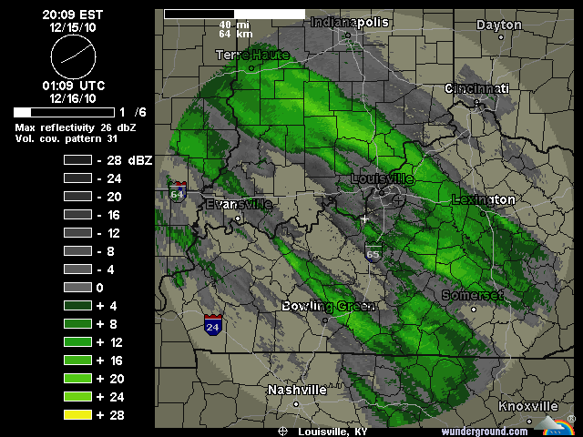
The bands of precipitation to the southwest of Louisville are filling in quite quickly and we'll see those come into the Metro area within the next hour or two. We're still on track for 1-2" of snow before 1am tonight, but a few of the short-range models are indicating a 2-4" accumulation in Louisville if these snow/sleet bands fill in and set up well. We'll see if that happens, but for right now all eyes are on the radar. The snow and sleet will eventually turn in to freezing rain sometime between 1am and 2am here in Louisville, but areas to our northeast across the Ohio River in Indiana will most likely stay all snow and sleet and see accumulations over six inches in some cases. Areas to the south and west of Louisville like Elizabethtown, Bowling Green, etc will have little snow and see mostly sleet and freezing rain tonight. The good news for them is that surface temperatures have a good shot at getting above freezing later on tomorrow, whereas here in Louisville and points north that probably won't be the case.
 I'm getting lots of questions about schools being open tomorrow and right now I can't supply a definite answer. Locally in Louisville I think the side roads and streets will be dangerous tomorrow morning (4-10am), so that will probably be a strike against schools being open tomorrow. Road crews are hard at work on interstates and major roads, but we'll see how surface temperatures cooperate with that overnight. Areas to our north with the heavy snow will also see many cancellations. This is still very much a "wait and see" game right now, but it's not looking too good for us weather-wise at the moment.
12/15 - 5:30pm - Louisville Winter Storm CRUNCH TIME!
 The onset of Louisville's first major mixed precipitation winter storm of the season is just hours away and the forecast is still very difficult. The National Weather Service has extended tonight's and tomorrow's Winter Storm Warning to counties in Southern Indiana that were previously only in an advisory. The reason for this is the increase in precipitation totals that both the NAM and GFS have been hinting at today. Those areas in Indiana will see all snow and sleet, with accumulations up to six inches in places.
 Here in Louisville the snow should start from the southwest near the 10pm hour and possibly mix with sleet before 1am, with accumulations of around 1-2". Based on the model guidance I've seen, I think we'll switch over to a period of sleet with some freezing rain mixed in after 1am. Freezing rain will become dominant in Louisville just a couple hours after that and last until around 7am with ice accumulations ranging from 0.25" to 0.5". The 18z GFS model (pictured top left) and the NAM both keep Louisville just below freezing at the surface during the entirety of the winter storm, but we're going to have to watch that. The snow we have on the ground will influence the surface temperatures across the area, so the computer models may be running too warm at this point. As I've said before, Downtown Louisville could get a degree or two above freezing during the afternoon and that will help road conditions improve tremendously. The 18z NAM BUFKIT output (second image on left) gives Louisville 1.7" of snow/sleet with a half inch of ice accumulation.

 Even with all of this data nothing is set in stone. The storm is forming to our west right now and we're already seeing light snow and sleet falling to our west and southwest. Watching the radar trends and surface observations overnight (called nowcasting) will be crucial to see who gets what kind of precipitation. Louisville is historically the battleground between precipitation types and we'll be in that situation for sure tonight. The HPC (Hydrometeorological Prediction Center) has Louisville and areas south in a Moderate Risk for 0.25" of ice accumulation. Louisville and points north have been put under a Moderate Risk for 4"+ of snow accumulation as well, so we may very well end up with quite a bit of both snow and ice here in the city.
 Should this system shift south just a few miles, Louisville would end up with mostly snow and accumulations would pile up to nearly half a foot. I've posted the 12z NAM snow accumulation output on the left just so you can see how incredibly close the heavy snow will be to Louisville, at least according to that model run. A shift northward would severely limit snow accumulations and put us in a mostly ice situation. Either way, Kentuckiana is set to get walloped by winter weather tonight. This will not be as bad as the January 2009 ice storm due to lesser ice accumulations and the potential for slightly above freezing temperatures during the daytime hours in Downtown Louisville and areas south of town as well. We'll see how it all plays out!
12/15 - 1am - Late Night Winter Storm Update

 I still think Southern Indiana north of Scottsburg will see mostly snow, which could add up to four or five inches especially as you head eastward. Here in Louisville we're on track to see a brief burst of moderate snow on Wednesday night before we go to sleet and then to freezing rain by Thursday morning. Like I said earlier today, Louisville's morning commute on Thursday is going to be treacherous if all the data we're seeing right now comes to fruition. Surface temperatures should be below freezing in Louisville throughout Wednesday night and Thursday (Downtown Louisville could get just above freezing on Thursday afternoon), so ice will have no problem accumulating on cars, roadways, overpasses, and everything in between. The computer models aren't accounting for the snow we have on the ground already, which will cool our surface temperatures, so it's difficult to gauge just where exactly it will get above freezing just south of town. The good part in all of this is that we will be fairly close to the freezing mark, which will make the salt on the roads much more effective. If surface temperatures were to be in the teens or 20's during this event, we'd have much worse road conditions. The HPC (Hydrometeorological Prediction Center) has points just south of Louisville in a slight risk for 0.25" of freezing rain or more (see right image), but we'll see how that plays out. I think we have the potential for 0.25" or higher of ice accumulation here in Louisville on Thursday, but those numbers will be fine-tuned as we get closer to time.
I'll post tomorrow with the latest data. Again, this storm won't break any records, but it will have a significant impact on much of Kentuckiana. Remember that I-64 and south will be under a Winter Storm Warning from tomorrow afternoon through Thursday afternoon and points north of I-64 will be under a Winter Weather Advisory for the same time period. The difference between these two is the potential ice accumulations, which warrant a Winter Storm Warning in place of an advisory.
Tuesday, December 14, 2010
12/14 - 1pm - Winter Storm WATCH for Louisville
 A Winter Storm WATCH has been issued by the National Weather Service for Louisville and surrounding areas until Thursday afternoon. An area of low pressure passing to our south will give us a quick-hitting winter storm, meaning we'll only see its effects in Kentuckiana from late Wednesday into midday Thursday. There's talk at the NWS of issuing an Ice Storm Warning for portions of Central and North Central Kentucky if the freezing rain accumulations appear that they'll get near a quarter of an inch.
Storm Timing
Wednesday morning/midday: All Clear
Wednesday afternoon/evening: Light snow/sleet begins in the west and spreads toward Louisville as snow. Under an inch of accumulation expected.
Early Thursday morning: Snow switches over to sleet and freezing rain, becoming mostly freezing rain as the morning wears on. The morning commute will be a royal mess in Louisville. Based on the forecast models and guidance I'm seeing right now, most schools should be closed or delayed on Thursday due to the treacherous driving conditions on Thursday morning. Areas north of Scottsburg, IN should have snow throughout the entire event and I would not rule out a couple inches of accumulation up that way.
Thursday afternoon: Near and south of the Ohio River should see freezing rain end from west to east in the early afternoon hours. There could be a few snowflakes as temperatures aloft cool down on the west side of the low. Again, Southern Indiana from Scottsburg northward should stay with snow and possibly a little sleet as this system pulls out of the area.

We'll see how this one plays out. The NWS in Louisville will upgrade the Winter Storm WATCH to either a warning or Ice Storm Warning at some point later today and I'll post the details of that on Twitter and Facebook immediately. Should any significant changes occur in the forecast, I'll post those on the blog.
Subscribe to:
Posts (Atom)