The HPC nailed the rain total estimates last night. They were calling for around .25" in Louisville and my rain gauge shows .21" from overnight. That's pretty close!
We're back to our old dry pattern again, this time with highs in the 60's and 70's. We'll be in the mid 60's tomorrow, upper 60's on Thursday, and then back into the 70's for the weekend. No rain chances until at least the middle of next week. On that note, there will be no blog posts or site updates from this Thursday until Wednesday of next week due to my fall vacation.

Tuesday, September 30, 2008
Monday, September 29, 2008
9/29 - 7pm - RAIN!!!
Was that title loud enough? We've got rain, actual rain, on the radar right now heading toward us! This system is still maturing, so its unknown how much rain we'll get exactly. Looking at guidance from the HPC suggests around a quarter of an inch. We'll still have drought problems even after this system comes through. The good part is that we'll end the streak of dry days over the past few weeks, helping some of the plants out that are still flowering. Not to mention the brown grass on everyone's lawn...
We should be dry tomorrow as this system exits late tonight. Temperatures will position themselves in the 60's and 70's over the next week with sunny skies to complement by Thursday.
Hurricane Kyle is history after hitting Nova Scotia. Subtropical Storm (no tropical characteristics) Laura has formed in the Atlantic, luckily with no consequence to land in the forecast track.
Sunday, September 28, 2008
9/28 - 5:30pm - A Beautiful Sunday Afternoon
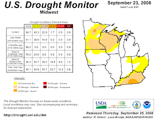
It's difficult to complain about our lack of rain when we've got comfortable temperatures and sunny skies. The fact of the matter is that we're in a moderate drought according to the US Drought Monitor:
We ventured out to Joe Huber Family Farm in Starlight, IN earlier this afternoon to pick apples and boy were they ripe! The nice weather attracted loads of people out to pick pumpkins and apples or simply relax and spend the afternoon shopping and eating.
Hurricane Kyle is barely hanging on as a hurricane right now, with winds at 75mph. It should make landfall in Nova Scotia as a strong tropical storm (technically an extratropical storm due to conversion to a cold-core storm) later tonight. All that's left for Maine right now is a Tropical Storm Warning.
There's still a small chance of rain for us Monday night into Tuesday, but the rest of the week looks dry. Tomorrow should be the last day in the 80's before we slide into the 70's and a few possible days in the 60's this week.
Saturday, September 27, 2008
9/27 - 1:20pm - New Forecast Video
More graphics updates this week... including the 7 day forecast! Tropical Storm Kyle is making its way north to Maine and Canada. While it won't be a monster storm, it will cause some problems up there. It shouldn't be too bad unless the forecast track changes dramatically.
UPDATE: Apparently this is the first Hurricane Watch posted for Maine in 17 years.
UPDATE: Apparently this is the first Hurricane Watch posted for Maine in 17 years.
Friday, September 26, 2008
9/26 - 5pm - TS Kyle, Rain Chances Slim
The low pressure area we've been talking about that's northeast of the Bahamas has now been named Tropical Storm Kyle. Contrary to the model hype earlier in the week, Kyle will not hit New York City or any large populous areas in the Northeast. Its current track grazes the coast of Maine before heading north to Canada:

Kyle will reach hurricane status by this weekend, but probably won't affect much of anything due to its location. It will hit the east coast of Canada as a tropical storm, but it should quiet down pretty quickly after heading inland. Pending any major track variations in the next few days, this should be a pretty forgettable storm.
We should stay dry as usual until Tuesday, when a weak front coming through could generate some showers. Again, optimism is pretty low at this point, so I wouldn't bet on seeing rain on Tuesday. Highs should decrease into the 60's and 70's next week!
Wednesday, September 24, 2008
9/24 - 4pm - Rain.... Please!
On my way home today, I saw that a creek near my house had completely dried up. That gave me a pretty good perspective on how our weather is right now: DRY. We might get a spot of rain Friday with a storm coming onshore in the Carolinas, but that's a stretch at this point. Expect temperatures to spiral down to 80 degrees by Friday after another hot one tomorrow.
That developing area of low pressure near Puerto Rico I talked about yesterday is not as organized as previously expected. Most models are still bringing it up to New England, but now most have it as a tropical storm now instead of a hurricane. Personally, I think this storm will barely materialize due to the possible tropical depression in the Carolinas throwing clouds over the Atlantic. This could limit solar heating on the water and cause interference with the water temperatures needed for this to form. This might have happened to Hurricane Gustav when Tropical Storm Hanna's cloud cover started intermingling with some of Gustav's, which could have made water temperatures drop in a crucial area of development. In any case, we'll have to watch both of these systems into the weekend.
That developing area of low pressure near Puerto Rico I talked about yesterday is not as organized as previously expected. Most models are still bringing it up to New England, but now most have it as a tropical storm now instead of a hurricane. Personally, I think this storm will barely materialize due to the possible tropical depression in the Carolinas throwing clouds over the Atlantic. This could limit solar heating on the water and cause interference with the water temperatures needed for this to form. This might have happened to Hurricane Gustav when Tropical Storm Hanna's cloud cover started intermingling with some of Gustav's, which could have made water temperatures drop in a crucial area of development. In any case, we'll have to watch both of these systems into the weekend.
Tuesday, September 23, 2008
5/18 - 5:30pm - It's a Bit Hot... Could We Really Have a New England Hurricane?
I noticed today as I was sitting outside eating lunch that it's a bit hot for September. Quantitatively, we're around 10 degrees above average for this time of year. We hit 90 degrees, which really hits this point home since our average high is 76 for today. Even though it's dry, it still got a bit uncomfortable in the sun this afternoon.
The GFS is now showing an area low pressure (possibly a tropical storm) coming ashore in North Carolina on Friday, giving us a small chance of rain on the same day. I'm not real optimistic with that right now, so don't get your hopes up for rain anytime soon. Still looks like next Tuesday has a better chance for rain, but that's subject to change this far out.
A few computer models are starting to unnerve some of the weather community today as they show a hurricane hitting New England this weekend:

(NOTE: The CLP5 and XTRP lines on the chart are not to be used as forecast tracks)
As the spaghetti chart says, this isn't even a tropical depression yet. Once it's a tropical storm, it's name will be Kyle (unless the low off of North Carolina beats it). The models are confused as all get out at this point, so none of these forecast tracks should be given more than a glance. As far as strength goes, most are shooting for a tropical storm or Category 1 hurricane. The outlier was the GFDL model which suggested a nasty Category 2 storm near Long Island, but I wouldn't give that prediction the time of day under the circumstances. We just need to sit back and watch this thing during the week.
Subscribe to:
Posts (Atom)