Showing posts with label Kansas. Show all posts

Thursday, June 28, 2012

6/28 - 11:30am MDT - Waking Up in Nebraska

After storms in Northeast Colorado yesterday became contaminated by storms coming off the Front Range, we decided to head east to be ready for today's chase. After waking up in Ogallala, Nebraska this morning we're rested up for a relatively leisurely day without too much driving since we're already pretty much in our target area for the day. The Storm Prediction Center has a general thunderstorm risk out for Western Nebraska, Northeast Colorado, and Northwest Kansas today with a 5% severe wind risk.

The focus today will be a cold front that's slowly moving through the region today. Winds around this frontal boundary may shift out of the east a little bit and that's where we'll position ourselves since the best shear will be where that happens. Dew points will be in the 60's across Central Nebraska this afternoon with slightly lower readings to the west. These surface winds, while weak, and the moisture should be more than enough to get some storms going.

Winds aloft are a little less certain since they may change throughout the day. Early on this morning winds at 500 mb (18,000 feet) were almost westerly across the western half of Nebraska, but already we've seen a shift to the southwest. While not terribly strong, the winds up there could have just enough punch to get storms to become severe. Small embedded shortwaves within the flow may enhance these winds a bit in some areas too. By 6pm MDT tonight the RAP model (right) still has these winds out of the southwest aloft, so that's some good news. The thinking at this point is that the shear won't be high enough to keep storms from merging together and being clustered, but we'll see how that plays out.

Follow me on Twitter and Facebook for constant updates during our chase!

Monday, May 28, 2012

5/28 - 10:30am - Video from Friday's Chase

Check out this video taken on Friday just south of Hays, Kansas during our storm chase. The supercell storm we followed for a good portion of that day had quite a bit of blowing dust and even a few gustnadoes. I wish I could have captured more of the gustandoes, but they were happening very quickly and usually while we were driving. This cell ended up producing a very brief, very small string-like funnel before it dissipated.

Saturday, May 26, 2012

5/26 - 11:35pm EDT - The Journey Home

Storms yesterday in Central Kansas did not produce a tornado for us. We did see a very brief string-like funnel at one point, but that was about the extent of our tornadic sights for the day. There were many tornadoes that touched down with damage reported closer sunset with these storms, but we had to make the judgement call to bug out and get back to Oklahoma City in time for people to get on their flights home before this happened. If these storms had organized a little quicker I think our chances of getting on a tornado would of been much better. The day began with a stop in Russell, Kansas where the Center for Severe Weather Research's ROTATE project happened to stop by for awhile. We were able to visit with them a bit and take some great pictures!

The chase began near La Crosse, Kansas where we followed a couple of developing supercells that had quite a bit of dust kicking out from under their ouflow. We followed a right-moving cell for quite some time, all the way to Bunker Hill, Kansas, as it cycled through weak and strong stages. This is the storm that produced the aforementioned string-like funnel cloud. Many a wall cloud came from this storm, but it was just too disorganized of a structure to get things going for a tornado. The storm that would form quite a few tornadoes (including an EF2-rated one near... you guessed it... La Crosse, Kansas) finally got its act together just to our southwest near sunset, but we had to bug out just as that was happening because we were so far away from Oklahoma City where we needed to be so that our tour guests could fly out. It's really too bad that we had to miss these tornadoes, but that's part of having to deal with the logistics of tour guests and the unpredictability of storm chasing. The storm structures were certainly spectacular though and we did see quite a few gustnadoes and dust being blow around. Video from these storms will be processed and uploaded tomorrow night when I get some time.

Yesterday and today have really been the same day for me. After we finished chasing in Central Kansas we had to make a bee line for Oklahoma City, where we made it in to town just after 3:30am this morning. My flight left at 7:35am this morning meaning I had to be at the airport around 6am, so I actually had no time to sleep in the interim. It's good to be back home in Louisville after being so tired! During these three weeks I've been with Storm Chasing Adventure Tours this month we've gone 8,383 miles across Oklahoma, Texas, New Mexico, Colorado, Nebraska, South Dakota, Iowa, Missouri, and Kansas. There are so many areas that we visited this season that I've never been to before, especially near the Mexican border in Laredo, Texas and Big Bend National Park. But I'm not done yet. After a few weeks at home and abroad, I'll be back out storm chasing again for a week starting on June 23rd and going through the 30th. This is typically a time where severe weather is found up north in the Dakotas and Nebraska, so I'll be flying out to Denver in about a month's time to meet up with everyone. A photo album of this year's chase so far can be found on my Flickr and Facebook accounts along with the slideshow below:

Friday, May 25, 2012

5/25 - 11:50am CDT - A Grand Finale

Ever since earlier this week we've had our eye on today's setup in Central Kansas. The moisture return, a low developing over Southwest Kansas, and upper-level wind support all kept us coming back to look at the models to see how it was shaping up. For a while it looked like the cap, or a layer of instability-inhibiting warm air aloft, was going to surpress storm formation but now we're seeing a situation where there will be just enough break in the cap to allow for a few isolated supercell storms to form. To get surface heating today to break that cap we need to clear out the clouds across Kansas first. A push of dry air at around 10,000 feet is currently moving from Southwest Kansas to the northeast and is eating these clouds for breakfast as you see in the satellite image to the right. We expect this to keep moving throughout the day and hopefully it will clear out the clouds in time to get some serious surface heating going.

The big story here today is the moisture return. For the first time this week we are seeing a situation where dew points will surge into the mid to upper 60's. Yes! This much-needed moisture will be the fuel for storms this afternoon and should give us a much better show than the moisture-deprived low-precipitation storms we've been seeing lately. While we don't have this moisture in the area quite yet, it's streaming in like crazy right now. Strong easterly and southeasterly winds are blowing this moisture into Kansas from Missouri and Oklahoma and will continue doing so throughout the day. Having mostly easterly winds in Kansas right now is a very good thing because this is creating just about optimal low-level shear for rotating supercell storms.

Speaking of wind shear, this will create quite a bit of helicity, or a corkscrew-like rotation of air in the atmosphere. When you combine helicity with instability in an equation you get the Energy Helicity Index (EHI). As I've said before I think that indicies and parameters can be distracting since human analysis is always better than a formula, but EHI seems to be fairly reliable since it is so basic and relies on two very basic ingredients. This afternoon's EHI values in Kansas will be the highest we've seen out here this season according to the Rapid Refresh model. That's some great news for storm chasers because higher EHI values typically correlate with enhanced tornado potential.

The Storm Prediction Center has a Slight Risk for severe storms today from Iowa to the Texas Panhandle and within that a 5% tornado risk in Kansas. This is quite the change from the previously non-severe "general thunderstorm" outlooks that they had been issuing for today because of the concern that strong capping may inhibit storm development. Today is our last chase day out here for Tour 3 and my last day out here until I come back for a week in June. If we could see some good storms today that'd be a great end to the first part of my trip! Tonight once we're finished chasing we'll be traveling back to Oklahoma City where I'll fly back to Louisville from tomorrow morning.

Follow up-to-the-minute reports on our chase on my Twitter and Facebook accounts!

Thursday, May 24, 2012

5/24 - 11:30am CDT - A Repositioning Day

Yep, there's a Moderate Risk for severe storms in parts of Wisconsin, Minnesota, and Iowa today according to the Storm Prediction Center. It's too bad because we simply can't chase there due to the amount of trees and vegetation along with a considerable distance from Oklahoma City where we need to be tomorrow night. Here's the plan then: We're going to drive south from Des Moines to Kansas City and then cut west in Kansas for this evening when we could see some overnight storms with lightning in that region.

Tomorrow still looks interesting to say the least. Right out front I need to say that this setup has a very high bust potential because of all the capping that will be in place. Warm temperatures of 10 degrees Celsius and higher at 10,000 feet (700 mb) will act as this capping mechanism because it will inhibit warm air from rising buoyantly into the layers above for thunderstorm formation. With that said, this cap may weaken just enough for a couple of storms to fire up in Kansas tomorrow. They would likely be very isolated due to the capped environment, so that's definitely a plus here.

We all know by now that the models have not been handling moisture very well lately and tomorrow probably won't be any different. The NAM model has dew points of 65 degrees Fahrenheit and higher in Central Kansas at 4pm CDT. If this is overdone and we see dew points between 60 and 65 degrees it still wouldn't be too bad. An area of low pressure smack dab over the middle of Kansas should help bring some of this moisture in and also create a considerable amount of wind shear for rotating storms, especially near the warm front just south of the Nebraska border. Again, this is all if the cap actually breaks tomorrow. If it doesn't we'll be sweating it out in the sun as we watch cumulus cloud towers fail to rise high enough for storms. Tomorrow morning I'll post again with an update on this potential.

Follow me on Twitter and Facebook for updates!

5/24 - 12:35am CDT - We're in... Iowa?

We didn't think we'd be in Iowa tonight. The storms that formed yesterday (Wednesday) rushed eastward as the cold front in the region decided to push further east than expected. Unfortunately none of these storms really did much because they formed in a linear fashion and didn't have the moisture necessary to get too severe. One of the southern cells in the line just west of Omaha, Nebraska managed to be isolated for a while and generated a wall cloud that triggered a tornado warning. Our only option in this environment was to cross the Missouri River in Omaha and wait for the storms to come to us because it would not be good to have the storms outrun us while trying to find a way across the river. The storms slowed down and died out pretty much at that point so we threw in the towel for the day.

Tomorrow will likely be a travel day back to Kansas or Southern Nebraska as we await Friday's potential chase setup. Storms tomorrow will be up near the Great Lakes in Wisconsin and Michigan and we just don't chase there due to the distance from the Plains and lack of good chase environment up there. Strong capping should keep storms from going up in the central and southern Plains, but we'll keep an eye on that in case that changes. Friday's setup may be decent if capping aloft doesn't ruin it. A deepening trough out in California and hopefully some better moisture return from the Gulf of Mexico should create potential for severe weather. A strengthening low in Southeast Colorado/Southwest Kansas should provide ample surface wind support for rotating storms should this pan out as forecast. The Storm Prediction Center already has a 5% risk area for this in their 3-day severe weather outlook. I'm crossing my fingers that this setup will yield some good storms because Friday is my last day chasing in the Plains until late June!

Follow me on Twitter and Facebook for updates this week.

Saturday, May 19, 2012

5/19 - 11:30pm CDT - New Tour Group, Chase Tomorrow

This morning Tour 2's guests departed and this evening we just finished up orientation and dinner with the guests on Tour 3. This past week we went 2,402 miles (3,866 kilometers) across Oklahoma, Texas, Colorado, and Kansas. Everybody had a great time as we traveled from the Mexican border near Big Bend National Park in Texas all the way to Denver even though storms may not have been available to chase every day.

A rash of tornadoes southwest of Wichita, Kansas near Harper has us a little down this evening since they happened during our day to switch up tour groups in Oklahoma City. Unfortunately there was damage reported with these tornadoes, which seemed to be all rope-like based on the photos being posted via social media. The rope structure of these makes sense given the low moisture in the area which means that cloud bases were high. For tomorrow the setup does not look as favorable for tornadoes given the still marginal amount of moisture in the region and weaker upper-level winds, but our sights are set on Western Oklahoma and the Panhandle region of Texas as the cold front that triggered today's madness continues southward.

The Storm Prediction Center has a general thunderstorm risk with a 5% severe probability for the area in question tomorrow. They're not real optimistic about severe storms based on the weak upper-level and surface winds, but we'll see how that develops tomorrow. The one thing we have going is that the direction of the winds at the surface (mostly easterly) will contrast well with the mostly westerly winds at 500 mb (18,000 ft) for some directional wind shear. Good storms may be hard to come by on Monday, but as the trough that I mentioned in the previous blog post begins to move in I think our prospects will improve during the week.

Follow me on Twitter and Facebook for the latest on our chase!

Friday, May 18, 2012

5/18 - 2:45pm CDT - Regarding Next Week's Chase

As we make our way back to Oklahoma City on our last day of this week's storm chasing tour, I'm looking over quite a bit of data for next week's severe weather potential. After a lengthy period of high pressure ridging across the Plains (A.K.A. no storms) we're finally seeing signs that a large-scale trough will begin to move onshore from the Pacific and begin to affect the Plains during the middle part of the week. A smaller trough will be coming through this weekend as well but not a lot of moisture and our inability to chase during its peak on Saturday due to our down day in Oklahoma City means it will not be discussed here.

This trough coming in next week will need some moisture to work with for severe weather to form. This is something we've had a problem with for a while now but it looks like the Gulf of Mexico will finally be "open for business" starting next week. As the trough begins creating southwesterly winds and diffluence aloft in Kansas extending into Northwest Oklahoma on Wednesday (5/23), southerly winds at the surface should begin to bring in some much-needed moisture. The degree to which this will happen is still very much up in the air at this point because the GFS model has been consistently overshooting actual dew points, meaning it's been too optimistic about moisture return. The European model does agree that moisture will begin flowing into the Plains on Wednesday, but to a lesser degree than the GFS on the right.

This setup will continue right into Thursday and Friday as the trough digs in and moisture continues to flow into the region. These two days may harbor better severe weather chances than Wednesday due to having more time for moisture to return. Given the possibility that small-scale weather phenomena like cloud shields and overnight storms could limit potential on any of these days it's very difficult to point out which of them will be the best for storm chasing. Not only that, but the aforementioned computer model issues and amount of time between now and the trough moving into the Plains creates an even bigger margin of error. It's safe to say right now that things are certainly looking more favorable synoptically (on a large scale) for severe storms, but calling for a tornado "outbreak" at this point wouldn't be logical due to the variability of all the smaller features involved. This setup certainly has our attention and we're keeping close watch! Our robotic streaming webcam has been sitting dormant since we haven't had any storms lately, but we're hoping that we can put it in action next week.

Follow my storm chasing updates on Twitter and Facebook!

Sunday, May 6, 2012

5/6 - 11:45pm CDT - Bust Today in Kansas, Texas Tomorrow

A layer of cirrus clouds really but a damper on our chase today as they blocked storms from forming along a cold front that was in the process of moving through Central Kansas and Northwest Oklahoma. The cold front also accelerated, which didn't help since areas that were prime for development had their warm, moist air swept out quickly. Storms did develop in Northeast Kansas today, but the potential up there for the best isolated storms was considerably less than where we were based on the data we use. Those storms were clustered together as expected, but a couple were able to get out by themselves for a bit and get a little rotation (one dropped a funnel cloud that possibly touched down briefly near Kansas City). At the end of the afternoon we ended up getting on I-35 and making our way south toward Texas where we want to be for tomorrow. Check out the nice sunset in the image on the right from Oklahoma City!

Tomorrow we'll likely be somewhere around South Central Texas, where the dry line will be the focus for storm development. Moisture will be plentiful there since the front we chased near today will not have swept through Texas yet. The dry line will not be terribly sharp in the area in question tomorrow according to the 0z NAM model. We really want that sharp dry line so that it provides good lift for storm development, but we'll see how it pans out tomorrow morning. The Storm Prediction Center's latest severe weather outlook has a Slight Risk for areas east of Fort Stockton tomorrow, but my hunch is that it may move east a little bit in their next outlook based on some of the data I've seen this evening. We'll look at the data tomorrow morning and I'll post on here once we're on the road!

Follow me on Twitter and Facebook for the latest tomorrow!

5/6 - 10:45am CDT - First Chase of the 2012 Season

Today we're headed to South Central Kansas for our first chase of the year. This is where a cold front will be moving through later on today that will provide a focus for severe storm development. What we're watching right now is an area of easterly winds near Wichita associated with a secondary low along the front. These winds will help to enhance directional wind shear (difference in wind direction at the surface compared to aloft) and may give us a hint of a chance at seeing a tornado.


Like I said in last night's post, the tornado risk isn't very big today because the winds aloft aren't that fast. You need these fast winds aloft to blow the downdraft with the cooling rain away from the updraft where the warm, moist air enters the storm. With the directional shear that I talked about though and some very strong instabilty, that may be able to compensate a bit for the lack of upper-level winds. Things like outflow boundaries from other storms may also help to get some low-level rotation going in a storm or two. Because of this the Storm Prediction Center has issued a 2% tornado risk for eastern portions of Oklahoma and Kansas.


We're also watching the visibile satellite view today because there is an area of slightly clearer skies in Kansas near where the winds are optimal at the moment. There are still quite a few high-level clouds, which may inhibit development a bit, but that shouldn't be much of a problem today. Storms will be clustered and mostly disorganized today thanks to that lack of good winds aloft and the cold front providing a broad area of lift. The trick will be if we can find any embedded organized storms with supercellular characteristics that might want to produce a weak tornado. We'll see how it goes!

Be sure to follow my up-to-the-minute updates on Twitter and Facebook today.


Saturday, April 14, 2012

4/14 - 2:30pm - Nice West TN Weekend, Outbreak in the Plains

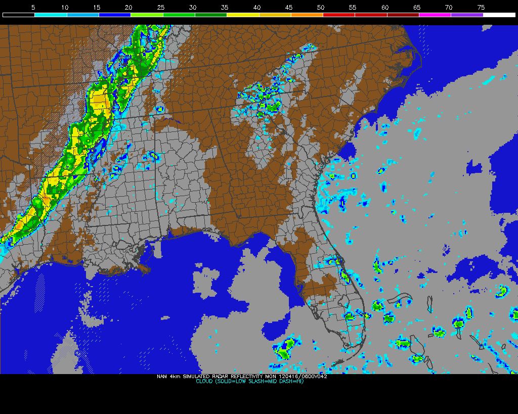
Sunday Night storms on NAM Model
It's a nice weekend across West Tennessee with warmer temperatures and breezy conditions. Another day of 80-degree weather is on the way for Sunday, but storms will roll through the region on Sunday night into Monday morning. Some of these storms could be a little strong, but they shouldn't be terribly severe, if at all, since they will be weakening as they approach the Mississippi River. Rain chances should subside completely after Tuesday and sunshine with highs in the 70's will be with us through the middle portion of the workweek. Check out my video from this morning below for more details!


A potent severe weather outbreak is just getting started in the Plains right now. Areas from Nebraska to Oklahoma are under a rare High Risk of severe weather from the Storm Prediction Center and violent tornadoes are expected this afternoon and evening. Already we've had quite a few reports of tornadoes touching down and doing damage in Kansas this afternoon, and more of the same can be expected as this system pulls more moisture northward and destabilization continues. On the left you'll see the latest EHI chart from the SPC, which is a measure of helicity (spinning motion in the atmosphere) and instability. This is a decent indicator of where the strongest tornadoes could form. It's really ramping up with values as high as 7 in Oklahoma right now, but those values are expected to increase and possibly move northward this afternoon and evening into Kansas and Nebraska.

Be sure and join me again on WBBJ for 7 Eyewitness News at 6 and 10pm tonight!

Saturday, December 17, 2011

12/17 - 11:50pm - A Not So White Christmas

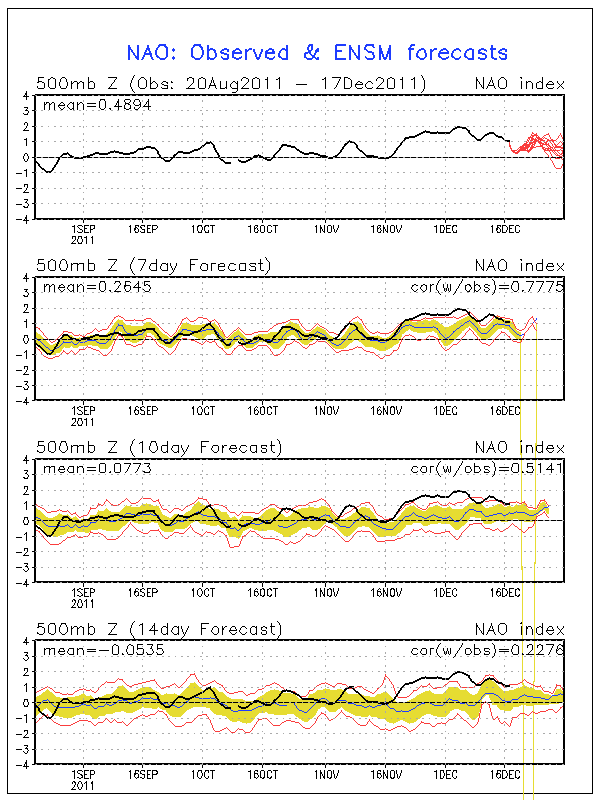
Positive NAO - http://www.ldeo.columbia.edu/NAO
Christmas is just a week away and snow chances for many in the eastern half of the nation look pretty bleak. The next major system to pull through on Tuesday and Wednesday will produce snow in the Plains, but to the east it's expected to be all rain. A second low moving through the Deep South on Friday will bring more rain, but most of that will stay south of Kentucky and the heaviest south of Tennessee. After that point it looks pretty dry right through Christmas. Why so rainy and relatively warm lately? It has to do with the North Atlantic Oscillation, or NAO for short. When the NAO is negative, storms tend to ride up the East Coast or just west of the Appalachian Mountains. This is a recipe for snow for many across the East since these storms have cold air streaming in just to the north of their track. When the NAO is positive, storms begin deflecting northward to Canada before they reach the Mississippi River. This means that the cold air and snow with these storms stays out in the Plains. The NAO is in this positive phase right now and isn't forecast to go neutral or even negative until around the new year (see forecast and history chart to the right). Until we can get the NAO negative, I wouldn't bet on a winter storm for Kentucky, Tennessee, or much of anywhere else in the East.

23% of the United States is covered by snow at the moment, which is quite a bit lower than the 47.3% covered by snow at this time last year. Aside from Lake Effect snowcover in Pennsylvania and New York and snowcover in northern Maine, the East is snow-less.

A big winter storm is forecast to hit New Mexico, the Texas/Oklahoma Panhandles, and Kansas on Monday and Tuesday as an area of low pressure cuts northeastward (because of the positive NAO as explained above) through the Plains. A Blizzard Warning (green color on right image) has been issued for Northeast New Mexico while the other areas are under a Winter Storm Watch. Areas in the core of the snowfall north of Amarillo, TX up through Dodge City, KS could get well over a foot of snow.

Saturday, May 21, 2011

5/21 - 3pm CDT - Back in Amarillo to Prepare for Next Week

We're in Amarillo today getting ready for another tour group to arrive. We washed and vacuumed the van (it was bad from all that Kansas dust), so we're ready for another week of storm chasing. We'll have two vehicles this week filled with excited storm chasing tour guests from all over the world, so it should be a good run.

SPC Severe Probability - Mon
Things are looking quite interesting next week, but we're meeting each risk of severe weather with tempered optimism after the problems that plagued our storms this week. Sunday looks to be a travel/sightseeing day because the risk of severe weather is too far east for us to travel from Amarillo and the terrain/vegetation in that part of the country presents even greater difficulty. Monday, on the other hand, looks pretty good. A surface low near the OK/TX panhandles should move in and deepen considerably throughout Monday, setting the stage for severe storms to erupt in West Oklahoma and Southwest Kansas. We'll likely play the Southwest Kansas component of this risk because of the east winds hitting the up-sloping geography with plenty of moisture in tow. Should be a decent tornado threat with this should it all pan out as the models indicate. The Storm Prediction Center has issued a 30% Slight Risk for severe weather in this area due to these factors.

SPC Severe Probability - Tues
Tuesday will be a very similar setup, just translated 150 miles east. The SPC has already outlined a risk area for Tuesday on their 4-8 day outlook, so they're confident this far out that something may happen. Wednesday, Thursday, and Friday may not be great chase days due to a small bit of ridging building into the Plains, but there's a possibility that a trough may move in soon enough on Thursday to where we may be able to chase in the North Plains of Nebraska and South Dakota. I sense a long drive back to Amarillo on Friday if that happens. The models are indicating that the severe weather setup may shift to the North Plains just in time for us to switch to our base in Denver next weekend. Let's hope so!


As always, you can follow me on Twitter and Facebook for the latest updates on our chase. Storm Chasing Adventure Tours also has a new Facebook page that you can "Like" to receive updates and photos from the group.

Friday, May 20, 2011

5/20 - 9:30am CDT - Bust Yesterday in Kansas

Cool temperatures aloft kept storms from being isolated in Kansas yesterday, resulting in a plethora of individual cells that quickly formed a line. Since each cell cut-off the other's inflow, none of these storms could get strong enough to produce a good tornado. There were a few brief tornadoes and funnels yesterday, but nothing worth writing home about. We were able to intercept a cell near Wilson, Kansas before it became completely linear yesterday and saw a rapidly rotating wall cloud with many finger-like funnels. Check out the video below to see it in action!


That storm had a history of producing a brief tornado, but the cell was moving too fast to intercept it at that point. After we left that storm, we traveled down to just north of Dodge City, KS, where an isolated supercell developed in the untapped warm air. We briefly saw what we thought to be a rope tornado from a few miles away, but it was too far to tell. This cell was spectacular for the few minutes that it stayed isolated yesterday and I was able to snap a gorgeous panorama of it as the sun went down:


I'll have an update from the road later on this morning... not quite sure if we'll chase in Oklahoma today or just head back to Amarillo so that our guests can prepare for their departure tomorrow.

Thursday, May 19, 2011

5/19 - 9:15am CDT - Let's Hope This One Works Out...

Today could be a big day in Tornado Alley. All the right ingredients seem to be coming together for quiet a severe weather event in Central Kansas this afternoon. Ample instability, upper-level winds from the southwest, surface east winds, and dew points possibly getting into the mid 60's this afternoon will fuel this event, which will likely produce the discrete or isolated supercell thunderstorms that we've been longing to chase all week. The fly in the ointment this morning is that there is a rather large cloud shield over the state that needs to move northeast before anything can happen. The sooner this happens, the better. Also, there's a dry slot aloft in the Oklahoma Panhandle that needs to make it here by this afternoon (that shouldn't be too much of an issue). If either of these things fail to happen, we could be stuck with a situation like yesterday where no storms form.

The Storm Prediction Center has issued a Slight Risk for Central Kansas this afternoon with a 10% hatched tornado risk. This is the biggest tornado risk that they've issued since I've been in Tornado Alley these two weeks so far. Here's an interesting tidbit from the SPC's discussion this morning:
A FEW DISCRETE SUPERCELLS APPEAR LIKELY WITH VERY LARGE HAIL AND TORNADOES POSSIBLE. ACTIVITY SHOULD DEVELOP NORTH-NORTHEASTWARD INTO CENTRAL KS DURING THE EVENING WITH A CONTINUED RISK OF SEVERE STORMS. STRENGTHENING LOW LEVEL WIND FIELDS DURING THE EARLY EVENING COULD RESULT IN A STRONG TORNADO OR TWO IN THIS AREA.
Pretty strong wording, no? Let's hope it all pans out for our sake and for all the other chasers out there who are starving for some activity.


Be sure to follow me on Twitter and Facebook for the latest photos and updates this afternoon!

Saturday, May 14, 2011

5/11 - 11:30pm CDT - Video of TIV 2 and TVN Dominator

Even though we didn't see any severe weather today, we were able to hang out in Pratt, Kansas for a little while to see the Tornado Intercept Vehicle 2 (TIV 2) and Tornadovideos.net's Dominator vehicle, both from Discovery Channel's Storm Chasers TV show. It was a rare find for us because it's not common to see both the TIV and Dominator in the same place at the same time. Discovery Channel crews were actively filming the show while we were there, and some of our group may even show up in the 'behind the scenes' episode that airs at the end of each show season. Check out the video below for a look at what we saw!

Wednesday, May 11, 2011

5/11 - 9:45am CDT - Southern Kansas Today

Our prospects for storm chasing this afternoon in Southern Kansas are not as good as previously thought. A line of storms that formed last night in the Texas Panhandle is drifting through west Kansas and Oklahoma right now. This is never a good thing because those morning storms can easily inhibit instability and make the potential for discreet super cells lower. BUT, once these storms depart the area and we get the sunshine back we'll begin to rebuild the atmospheric potential for severe weather this afternoon. The sooner the storms leave, the better things will be this afternoon. Because of these developments, the Storm Prediction Center has downgraded their Moderate Risk from last night to a Slight Risk this morning.


We'll see how it all goes today. East surface winds, a dryline push, and good wind speeds at 500mb (but a bit too southerly for comfort) are all in our favor for today despite the morning storms. I'm confident that severe weather will happen today in Kansas/Oklahoma, but the setup has become much more complex and the potential for good discreet supercells has decreased.

Storms will most likely start after 2pm CDT this afternoon. Be sure to follow me on Facebook and Twitter for the latest updates!

5/11 - 1:30am CDT - We Saw The TIV in Pratt, Kansas!

We rolled into Pratt, Kansas, where we're staying overnight to position for tomorrow's chase, to quite a show this evening. The Tornado Intercept Vehicle 2 (TIV2) and TVN's Dominator vehicle were both in town waiting for tomorrow's chase and shooting video for the Discovery Channel's Storm Chasers TV show. We got up close and personal with the TIV as its driver Marcus Gutierrez gave us a tour of its features in a parking lot near our hotel. It's a magnificent vehicle even though it's prone to mechanical problems and glitches. Check out the Flickr player below for photos of our tour:


It still looks like we'll be in Central Kansas, our current location, or Western Oklahoma tomorrow (well, later today) for what could be a substantial tornado outbreak. The Storm Prediction Center has issued a Moderate Risk with a 10% tornado risk for this area and as long as everything sets up according to plan, it should be a good chase. I'll have more details early tomorrow morning after a quick sleep tonight!

Sunday, May 8, 2011

5/8 - 7:30am CDT - Heading North This Morning

We'll most likely head north to either Northern Kansas or Southern Nebraska as the severe weather setup in that vicinity seems to be shaping up rather well. The SPC has issued a Slight Risk for most of Nebraska and South Dakota, with a little bit of North Kansas thrown in. A 5% tornado risk has also been issued for this area. An eastward push of the dry line and easterly surface winds up that way should fire off rotating supercells this afternoon provided that enough moisture makes its way northward as advertised on the computer models this morning. A batch of rain is currently moving through the north and east portion of Nebraska, but that should not contaminate our target area.

LCLs (cloud bases) will be very low in North Central Kansas and most of Nebraska, which is always a good thing for tornado development (click right image for LCL forecast). Upper-level winds are not terribly strong (30-35kt at 500mb), but that should be enough to get things going. Storms that form may only move at 10kt this afternoon according to the 6z NAM, and that coupled with about 40kt of bulk shear should make for a batch of slow-moving supercells. CAPE or instability values of over 3000 J/kg will also be crucial to the development of these cells today.

Should anything change dramatically in our target area plans, I'll post a brief update here from the road. Don't forget to follow me on Facebook and Twitter for all the latest reports and photos while we're chasing!

Saturday, May 7, 2011

5/7 - 4pm CDT- Hello From Amarillo, TX!

I'm all settled in here at our hotel in Amarillo after a flying in from Louisville. Tonight our tour guests on tour 2 will gather for orientation at a conference room here in the hotel and then we'll go out for a nice dinner before a week of gas station burritos and fast food while chasing.

As a tradition during each tour that departs from Amarillo, the restaurant we'll be eating at is the world-famous Big Texan Steak Ranch. This place is the real deal here in the Texas Panhandle if you're looking for a taste of the stereotypical "Wild West". At the center of the two-floor establishment is an elevated table where diners can try their hand at eating a 72oz steak (with side dishes) within an hour's time. Besides being the spotlight for all the diners at the restaurant, each participant's attempt at eating this behemoth is streamed live online via a video camera mounted on the second floor. It's a fun place and it certainly starts each tour with a lighthearted ice-breaker for everyone.

Tomorrow's target will be a spit decision. Our target area will most likely be somewhere near Wichita Falls, Texas, which is just a few hours drive from Amarillo, or Northern Nebraska (maybe Kansas?). The SPC has a Slight Risk for severe weather posted for West Oklahoma/North Central Texas and Northern Nebraska/Southern South Dakota, but we'll see how everything sets up in the morning before deciding on a specific target area.

The NAM model has a good setup for the Texas/Oklahoma border near Wichita Falls right now with high CAPEs, serviceable wind shear, and decent low-level moisture. The LCLs (Lifted Condensation Level - height of cloud bases) are a little high for my taste at 3000 to 6000ft, which could limit tornado potential in any supercell that fires up. The other chase target in Northern Nebraska/Southern South Dakota (or Northern Kansas based on some of the newest model output) seems to have most of the characteristics of the Texas/Oklahoma one, but LCLs will be slightly lower and shear values could be higher. Those two components alone lead credence to a higher tornado threat, but there's concern that moisture from Texas won't make it up there in time for the advertised severe weather development (see right image - 850mb dew points at 0z Monday). We'll see how it looks in the morning before a final judgement is made!

Be sure to keep up with my updates on Twitter and Facebook for all the latest information while we're chasing tomorrow!