Ready for a REAL taste of fall? It's here.... and It's going to stick around for quite awhile. A large mass of cool air continues to work its way into West Tennessee this morning behind yesterday's cold front. That means temperatures today will be getting into the upper 50's across the region. By the time we get to late tonight and early tomorrow morning we'll be talking about mid to upper 30's for lows. Bundle up! High pressure will keep this cooler air locked in place through the week and sunshine will be plentiful as it has been in most places today. We'll need to watch for some frost in areas during the mornings starting on Monday as temperatures fall to near freezing overnight. High temperatures will slowly work their way to near 70 degrees by the end of the workweek.
Let's talk about Hurricane Sandy. It's a weak hurricane right now but the setup is more complicated than just that. As it moves toward the Northeast it will merge with a trough moving across the eastern half of the nation. This will transition the storm from a hurricane to what's called an extratropical storm. Basically this means that the storm won't feed off of warm water like a tropical system would. This will turn Sandy into the very, very large storm that its already beginning to become. Threats for wind damage, storm surge, and flooding will be possible for a broad swath of the Delmarva Peninsula through New England. New York City, Philadelphia, and Washington DC are included in this among many other locations. The storm surge issues will be amplified by the size of the storm, which moves more mass of water, and by the fact that this will be happening during a full moon, which maximizes tide. Check out the tropical storm force wind probabilities to the right... this is pretty significant when you consider there's a 60-70% of sustained tropical storm winds from Delaware to Long Island.
Another threat this storm poses is snow. West Virginia with its higher elevations will bear the brunt of the snow with 1 to 2 feet expected in areas. The latest run of the GFS model paints a very large area of 18"+ snowfall amounts through Tuesday evening. This could be crippling because there are still leaves on the trees that this heavy, wet snow will weigh down on snap limbs. Mass power outages are very likely whether you're in the wind/rain area in the Northeast or in the snow area in West Virginia.
In the video below you'll get a full dose of information on Hurricane Sandy and your latest West Tennessee forecast.
Showing posts with label Good Morning West Tennessee. Show all posts
Saturday, October 27, 2012
10/27 - 5pm - Quiet in West Tennessee, Sandy Takes Aim
Labels:
7,
ABC,
CBS,
Good Morning West Tennessee,
hurricane,
Jackson,
power outage,
Sandy,
snow,
tropical storm,
TV,
video,
WBBJ,
West Tennessee,
wind
Saturday, April 28, 2012
4/28 - 4:45pm - Hot Weather, Fun Show at WBBJ!
Today marks my last show at WBBJ until August when I come back from my college summer break. And boy what a fitting show it was. Of course the weather is going to be hot and muggy through next week with pretty consistent small daily storm chances (each day except Wednesday). A pesky frontal boundary sticking around the region for a few days before eventually lifting northward will be the culprit for these pop-up showers and storms. You can check out the video from this morning's weathercast below. The big show today was an interview by Myles Savage, the lead singer from the Platters, this morning on our show. He gave a fun and spirited performance that none of us in the studio will ever forget! The video of his interview is below my weathercast. Enjoy!
Just ONE WEEK until my first three weeks of storm chasing begins in the Plains!
Labels:
7,
ABC,
CBS,
Good Morning West Tennessee,
hot,
Jackson,
media,
meteorology,
storm chasing,
tennessee,
TV,
video,
WBBJ
Saturday, April 21, 2012
4/21 - 9:45pm - Cooler, but Sunny Weather Ahead!
Labels:
7,
ABC,
CBS,
earth day,
Good Morning West Tennessee,
Jackson,
media,
meteorology,
tennessee,
TV,
video,
WBBJ
Saturday, April 14, 2012
4/14 - 2:30pm - Nice West TN Weekend, Outbreak in the Plains
![]() |
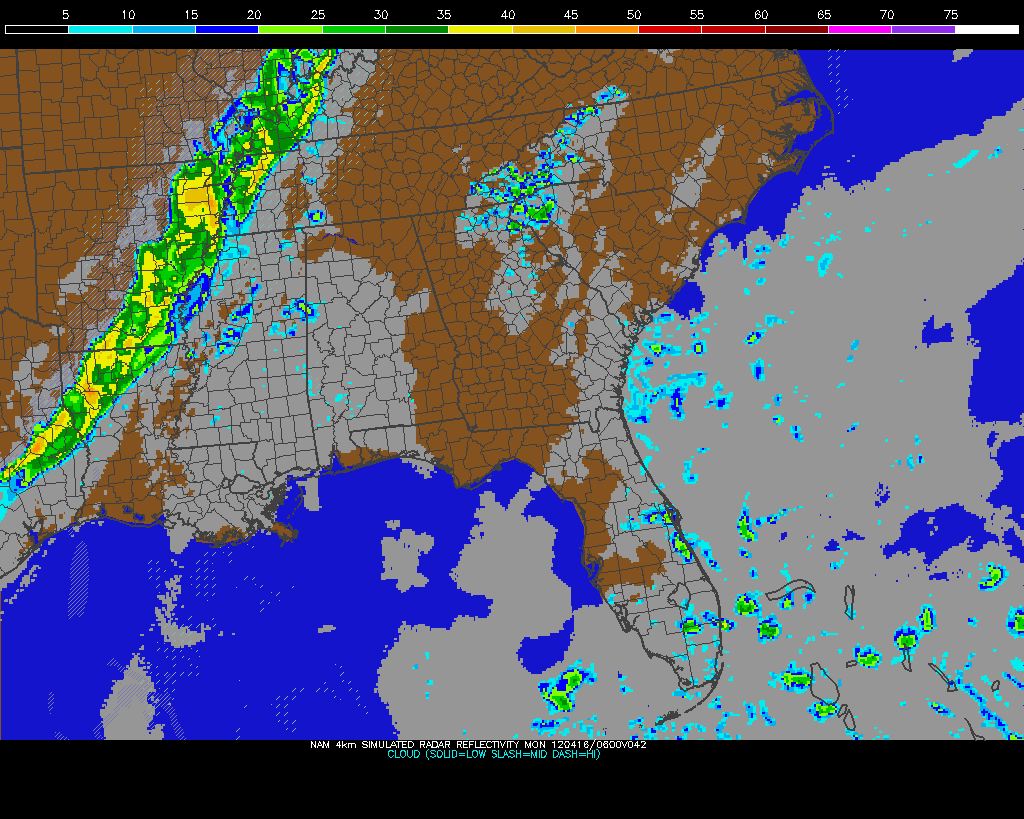
| Sunday Night storms on NAM Model |
A potent severe weather outbreak is just getting started in the Plains right now. Areas from Nebraska to Oklahoma are under a rare High Risk of severe weather from the Storm Prediction Center and violent tornadoes are expected this afternoon and evening. Already we've had quite a few reports of tornadoes touching down and doing damage in Kansas this afternoon, and more of the same can be expected as this system pulls more moisture northward and destabilization continues. On the left you'll see the latest EHI chart from the SPC, which is a measure of helicity (spinning motion in the atmosphere) and instability. This is a decent indicator of where the strongest tornadoes could form. It's really ramping up with values as high as 7 in Oklahoma right now, but those values are expected to increase and possibly move northward this afternoon and evening into Kansas and Nebraska.Be sure and join me again on WBBJ for 7 Eyewitness News at 6 and 10pm tonight!
Saturday, April 7, 2012
4/7 - 7:15pm - Fantastic Easter Weekend
Mostly sunny to partly cloudy skies will be with us in West Tennessee and North Mississippi for Easter Sunday tomorrow with temperatures in the lower to middle 70's. Some like it hot and some like it cold, but I think most like it like this! The clouds we'll see tomorrow will be generated by a cold front that will move through early in the morning, but I think rain chances are zero for tomorrow at this point because there is very little moisture in the air. Another one of these dry cold fronts will move through on Monday, but this time it will bring a batch of cooler air that should bring temperatures down into the 60's for highs on Tuesday and Wednesday. Get a full look at your forecast in my video below from this morning:
Saturday, March 31, 2012
3/31 - 3pm - Severe Risk in West Tennessee
Storms are already popping up in Tennessee as a weak disturbance aloft is allowing the warm, moist air that we have at the surface to rise. A Severe Thunderstorm Watch is in effect for a good deal of West Tennessee until 9pm CDT tonight and the main risks from these storms should they become severe will be large hail and wind. With temperatures aloft being so cold the storms should be able to produce hail easily today. Might want to think about putting your car in a garage or carport if you have one.
Instability is already building across the region as you'll see on the right image. Storms have not really broken out across West Tennessee yet because a weak warm layer aloft known as the "cap" is prohibiting air from rising. Once we get a degree or so warmer that cap should erode and storms will form. This will not be a tornado day because wind shear is very, very weak.Check out my forecast from this morning on WBBJ below:
Be sure and catch me on 7 Eyewitness News again this evening at 6 and 10 o'clock!
Saturday, March 24, 2012
3/24 - 3:30pm - Another Very Warm Week Ahead
A few showers have moved through West Tennessee this morning and we're still holding on to a chance for a few more mixed with some thunderstorms developing this afternoon. There could be a strong storm or two, but it shouldn't be a big deal. Once the big upper-level low generating the showers and this afternoon's storm chance moves on through we'll be seeing clearing skies and temperatures in the mid 70's by tomorrow. The early part of your workweek looks sunny as high pressure builds in once again and we should see highs go 80+ once again by Tuesday. The middle and end of the week are somewhat in question right now, but it seems as though another slow-moving system may generate at least a few showers and storms during that time frame. Check out one of my weathercasts from this morning's Good Morning West Tennessee broadcast on WBBJ for more details:
Labels:
7,
ABC,
CBS,
Good Morning West Tennessee,
Jackson,
meteorology,
rain,
spring,
tennessee,
thunderstorm,
TV,
ULL,
warm,
WBBJ
Saturday, March 3, 2012
3/3 - 9pm - A Much Quieter West Tennessee Forecast
West Tennessee was spared from the bulk of the severe weather yesterday. As the cold front pushed through last night much cooler air filtered into the region and we'll see more seasonable weather for the next few days. It will also be quiet compared to the last couple of weeks, so be sure to enjoy these few days of sunshine! Check out your latest forecast from this morning's edition of Good Morning West Tennessee Saturday on WBBJ below:
Labels:
7,
ABC,
CBS,
Good Morning West Tennessee,
Jackson,
media,
meteorology,
severe,
tennessee,
TV,
video,
WBBJ
Saturday, February 25, 2012
2/25 - 5pm - Simple Weekend Forecast, Then Things Get Complicated
After a cold front moved through Thursday giving us cooler temperatures for the last few days we'll finally begin warming things back up again in West Tennessee as high pressure begins to channel warm, southerly winds back into the region. Jackson should get above 60 tomorrow with sunny skies while Monday could be even warmer in the mid 60's with a few clouds. We'll get enough of this warm, moist air in the region to begin turning our attention to the threat of strong storms on Tuesday evening. The Storm Prediction Center has already put West Tennessee and North Mississippi in a risk area for severe weather on Tuesday on their extended outlook (right).
It's not entirely clear how this will play out right now, but the latest data suggests a threat for damage from straight-line winds. The worst severe weather will likely be in Mississippi where moisture will be more plentiful. My main concern at this point is where winds near the surface will be during this event. A secondary disturbance (called a prefrontal trough - see left) could be not only a trigger for storm development, but it may very well turn winds across West Tennessee and North Mississippi out of the southeast. This would increase low-level directional wind shear and hence increase the chance for tornadic activity on Tuesday evening. Again, it's still too far out to make an accurate assessment on this so we'll be watching throughout the remainder of the weekend and into next week. There may be a shot of severe weather as we head into Friday as well, so the pattern will certainly return to an active state after this nice weekend. Check out my forecast from this morning at WBBJ below:
It's not entirely clear how this will play out right now, but the latest data suggests a threat for damage from straight-line winds. The worst severe weather will likely be in Mississippi where moisture will be more plentiful. My main concern at this point is where winds near the surface will be during this event. A secondary disturbance (called a prefrontal trough - see left) could be not only a trigger for storm development, but it may very well turn winds across West Tennessee and North Mississippi out of the southeast. This would increase low-level directional wind shear and hence increase the chance for tornadic activity on Tuesday evening. Again, it's still too far out to make an accurate assessment on this so we'll be watching throughout the remainder of the weekend and into next week. There may be a shot of severe weather as we head into Friday as well, so the pattern will certainly return to an active state after this nice weekend. Check out my forecast from this morning at WBBJ below:Saturday, February 18, 2012
2/18 - 2pm - Somewhat of a Snowy Fizzle
Last night's model runs were coming in very bullish for snow in West Tennessee on Sunday morning and I was even putting together a graphic very early this morning that had 2-4" of snow in Northwest Tennessee. As the 6z model runs came in there was a pretty stark change in the forecast all because of one fact: two waves in the upper atmosphere were not phasing (or joining forces) as quickly as previously predicted. This means that the cold air from the northerly wave will not inject itself into the southerly one until it reaches Nashville. Without this cold upper-air support, the chance for snow dwindles considerably.While some light accumulations are possible in Northwest Tennessee tomorrow morning, much of the region should remain plain rain with some mixed in snowflakes. A brief burst of snow may happen later on Sunday morning as this system pulls out of the area, but even in areas with accumulation it should not cause problems on the roads due to above freezing surface temperatures. Areas north and east of Nashville, however, will see the accumulating snow and some of it could be on the heavy side.
Once the rain and snow is gone later on tomorrow morning we should be left with cloudy skies and cooler temperatures in the 40's across West Tennessee. There are a couple rain chances thrown in next week on Tuesday and Wednesday, but the rest of the week should be relatively warm and dry. Check out the video below for your complete forecast (Note: I left my TV tuner for my laptop in Mississippi so I don't have a longer copy of this video):
Saturday, February 11, 2012
2/11 - 5pm - A Wintry West Tennessee Forecast
A front that passed through West Tennessee last night brought rain showers during the overnight hours and snow showers this morning across the region. These have since moved out of the area, but the snow came down in some heavy bursts at times even though there was really no accumulation. High pressure will provide the setup for a very cold couple of days with highs in the 30's and overnight lows in the teens. Yikes! Tonight could be the coldest night of 2012 so far, which really isn't saying much since we've been pretty mild as of late.
Monday's forecast is flat-out complicated. Warm air overriding the retreating arctic air mass in place from this weekend will set the stage for a storm that could put down snow, sleet, and even freezing rain. Most indications are that this will start off as snow across most of West Tennessee on Monday afternoon as the lower layers of the atmosphere moisten up, but this snow could switch over to a period of wintry mix later on in the evening as the atmosphere warms up more (notice the warm "push" at 850 mb - 5000 ft on the left). Once we reach a certain threshold of warming on Monday night into the wee hours of Tuesday morning, all the snow, sleet, and freezing rain should transition to plain rain and the wintry weather headaches will be no more. Before everything switches over to rain an inch or so of snow could be on the ground around the I-40 corridor, including Jackson,
according to the latest forecast models. Areas in Northwest Tennessee will switchover to rain a little later on than I-40, so there may be up to two inches on the ground. This is nowhere near set in stone yet and I'm willing to bet we'll see a few small changes in this forecast before the weekend is over.
The models agree that snow will fall across West Tennessee on Monday, but there are differences in when exactly this warm layer aloft will come in enough to switch the snow and wintry mix over to rain. The 18z NAM seems the most conservative on snow amounts at this point, with only a half inch in Jackson on Monday night. It also suggests that we might avoid a wintry mix and switch immediately over to rain. There's even a brief shot of rain just before the snow starts on that model. The GFS is bullish on snow amounts with over an inch in Jackson with the aforementioned wintry mix period (depicted as freezing rain on the BUFKIT output to the right) before the switchover to rain. The main issues seem are the timing of the warm air intrusion aloft and how strong it will be. So while this won't be a huge winter weather event by any stretch of the imagination, a few travel issues may crop up on Monday evening as the snow and wintry mix is falling. Check out the video below from this morning's newscast on WBBJ for more details on your forecast!
Saturday, February 4, 2012
2/4 - 4pm - Storms Come to an End Across West TN
After a round of showers and storms this morning, a cold front is now moving across the Mississippi River into the state. The cold air and clouds with the storms this morning stabilized the atmosphere considerably, so storms will not re-fire this afternoon as previously forecast. This also means that our marginal risk for severe weather today is done. Instead a few areas of drizzle may pop up as the front moves through by this evening. After a few showers tomorrow, calm and mostly clear conditions should prevail for the rest of next week. Check out my forecast from this morning on WBBJ below:This morning I walked into the studio and our weather center was completely gutted! WBBJ is starting to disassemble it to make room for our new set, which will include a shiny new weather center once completed. For now our weather operations are running from a temporary location just off-camera, which you can see in the panoramic photo I shot this morning:
Labels:
7,
ABC,
CBS,
Good Morning West Tennessee,
Jackson,
meteorology,
no severe,
radar,
tennessee,
TV,
video,
WBBJ
Saturday, January 28, 2012
1/28 - 3:30pm - A Tranquil Forecast, Thundershower Photos
It doesn't get much better than this. After a bit of chilly weather today with highs in the 40's we'll be seeing the triumphant return of 50's and 60's next week across West Tennessee. This rather warm stretch of weather with sunny skies will extend all the way through to Tuesday. A few showers and storms could make their way into the region by Wednesday and Thursday, but other than that the rest of the week should remain rain-free for the most part. There are indications that some colder, more winter-like weather could arrive after next weekend, but we'll cross that bridge when we get closer to time. Check out your full forecast from this morning's edition of Good Morning West Tennessee on WBBJ below:
On Thursday a few thundershowers rolled through Mississippi State University as a cold front made its way across the region. Since skies had cleared out from the day's previous storms, the coupling of the sunset and the thundershowers with clear air around them made for some nice photos. A "silver lining" of one of these thundershowers is posted on the right and a panoramic view of the MSU campus from the 4th floor of my building as the showers rolled through is below:
Click photo for a larger view.
Labels:
7,
ABC,
CBS,
Good Morning West Tennessee,
Jackson,
media,
meteorology,
Mississippi,
Mississippi State,
tennessee,
TV,
video,
warm,
WBBJ
Saturday, January 21, 2012
1/21 - 11pm - Severe Weather Outbreak Possible Tomorrow
A line of strong storms moved through West Tennessee this morning, but what's on the way for tomorrow evening could be even more potent with the potential for damaging winds and tornadoes. Check out my broadcast from this morning below to see what all this means and then continue on below the video for a detailed severe weather breakdown:
The Storm Prediction Center has issued a Slight Risk with a 30% hatched area for tomorrow's severe weather event from Mississippi to Indiana. The main time frame for these storms to roll through West Tennessee and Mississippi will be from 5pm tomorrow to 3am Monday. This does not mean ten straight hours of storms in any one location, but rather a ten hour window where storms will be affecting the region. Wind damage and hail will be the most common threats, but this could also be a significant tornado event. Some individual supercells or cell clusters may form ahead of a main QLCS (squall line) of storms late tomorrow afternoon and evening. These front-running storms, should they form, would be the ones with the highest tornado risk, but both the line of storms and the individual cells could produce a significant tornado or two. The SPC's wording on their Slight Risk outlook is fairly strong:
The setup for tomorrow's severe weather event is fairly classic. A large trough will be moving through the region providing increased wind speed aloft, which increases instability and provides wind shear. This trough will also be negatively tilted, meaning the axis or tightest gradient of the trough will be leaning from southeast to northwest as you see in the graphic to the right from the 0z NAM model. This negative tilting further increases wind shear because the upper level winds take on a more southerly component rather than a southwesterly one.
Not only will we have wind shear between the surface and aloft, but also the surface and the low levels of the atmosphere too. This low-level shear is essential for tornadoes to form and for storms to overcome low levels of instability. The NAM output has quite a bit of low-level shear from Mississippi all the way to Kentucky, so that's a pretty good indication that rotating storms and tornadoes will be possible during the duration of this event tomorrow.
The amount of moisture that will be surging up from the Gulf of Mexico while the region is in the warm sector of this system is going to be tremendous. The current dewpoint in Starkville, Mississippi is 41 degrees, but by tomorrow evening we'll be in the 60's. That is certainly enough moisture to supply the atmosphere with the needed instability for severe weather.
When you put together these factors plus the idea that we may have CAPE (instability) values over 1000 J/kg, you get a fairly decent tornado risk. The Significant Tornado Parameter exceeds 2 on the 21z SREF model at 9pm and midnight (1/23) tomorrow and has been fairly consistent on the last few runs of the SREF. This is not "off the charts" or anything like that, but it's enough to raise eyebrows. As stated above, both individual cells and the main QLCS line of storms could produce strong tornadoes. The QLCS will be especially difficult because there could be embedded supercell structures within it that produce tornadoes like an individual supercell would. I still think the highest tornado risk will be in Northeast Mississippi (Starkville, West Point, Columbus, Tupelo, Corinth, etc.), but the latest indications like the STP above are pointing toward that threat leaking over into southern portions West Tennessee as well.
I'll be updating my Twitter, Facebook, and Google+ accounts all day tomorrow as these storms roll through, so be sure to follow or friend me for the latest information.
Timing and Threats
The Storm Prediction Center has issued a Slight Risk with a 30% hatched area for tomorrow's severe weather event from Mississippi to Indiana. The main time frame for these storms to roll through West Tennessee and Mississippi will be from 5pm tomorrow to 3am Monday. This does not mean ten straight hours of storms in any one location, but rather a ten hour window where storms will be affecting the region. Wind damage and hail will be the most common threats, but this could also be a significant tornado event. Some individual supercells or cell clusters may form ahead of a main QLCS (squall line) of storms late tomorrow afternoon and evening. These front-running storms, should they form, would be the ones with the highest tornado risk, but both the line of storms and the individual cells could produce a significant tornado or two. The SPC's wording on their Slight Risk outlook is fairly strong:
AN APPRECIABLE SEVERE EVENT IS POSSIBLE ACROSS THE REGION SUNDAY NIGHT/EARLY MONDAY...INCLUDING THE POTENTIAL FOR TORNADOES AND DAMAGING WINDS. AN UPGRADE TO A CATEGORICAL MODERATE RISK MAY BE WARRANTED IN SUBSEQUENT OUTLOOKS FOR PORTIONS OF THE REGION.
Setup
The setup for tomorrow's severe weather event is fairly classic. A large trough will be moving through the region providing increased wind speed aloft, which increases instability and provides wind shear. This trough will also be negatively tilted, meaning the axis or tightest gradient of the trough will be leaning from southeast to northwest as you see in the graphic to the right from the 0z NAM model. This negative tilting further increases wind shear because the upper level winds take on a more southerly component rather than a southwesterly one.
Not only will we have wind shear between the surface and aloft, but also the surface and the low levels of the atmosphere too. This low-level shear is essential for tornadoes to form and for storms to overcome low levels of instability. The NAM output has quite a bit of low-level shear from Mississippi all the way to Kentucky, so that's a pretty good indication that rotating storms and tornadoes will be possible during the duration of this event tomorrow.
The amount of moisture that will be surging up from the Gulf of Mexico while the region is in the warm sector of this system is going to be tremendous. The current dewpoint in Starkville, Mississippi is 41 degrees, but by tomorrow evening we'll be in the 60's. That is certainly enough moisture to supply the atmosphere with the needed instability for severe weather.
When you put together these factors plus the idea that we may have CAPE (instability) values over 1000 J/kg, you get a fairly decent tornado risk. The Significant Tornado Parameter exceeds 2 on the 21z SREF model at 9pm and midnight (1/23) tomorrow and has been fairly consistent on the last few runs of the SREF. This is not "off the charts" or anything like that, but it's enough to raise eyebrows. As stated above, both individual cells and the main QLCS line of storms could produce strong tornadoes. The QLCS will be especially difficult because there could be embedded supercell structures within it that produce tornadoes like an individual supercell would. I still think the highest tornado risk will be in Northeast Mississippi (Starkville, West Point, Columbus, Tupelo, Corinth, etc.), but the latest indications like the STP above are pointing toward that threat leaking over into southern portions West Tennessee as well.
I'll be updating my Twitter, Facebook, and Google+ accounts all day tomorrow as these storms roll through, so be sure to follow or friend me for the latest information.
Labels:
7,
ABC,
CBS,
dew point,
Good Morning West Tennessee,
Jackson,
Mississippi,
Mississippi State,
model,
NAM,
severe,
shear,
spc,
SREF,
starkville,
tornado,
WBBJ
Saturday, January 14, 2012
1/14 - 10pm - All Sorts of Interesting Weather Today!
![]() |
| Henderson County, TN |
What is an Alberta Clipper? Put simply it's a fast-moving area of low pressure that dives southward from the area near Alberta, Canada in the wintertime and spreads light snow to the Midwestern states. This particular Clipper was an interesting one because it centered its maximum snowfall in a very small area as the storm moved through Kentucky and Tennessee. More specifically, this area was just south of Louisville from Harrison County, Indiana to just south of Lexington, KY. Accumulations vary widely in Louisville because of the scattered nature of the snow bands that moved through, but they seem to range between a half inch to around two inches. South of town there are reports of more than three inches around Bardstown and Taylorsville! NWS Louisville's forecast graphic from earlier this evening points out pretty well where the most snow has fallen and you can tell exactly where the heavy snow band sat this afternoon. I drove through this band near Radcliff, KY on my way from Jackson, TN to Louisville and I can verify that it was indeed very heavy as indicated on the map. I took a quick video of today's snow at my house in Southeast Louisville just as I got home for my long weekend:
Labels:
7,
ABC,
CBS,
clipper,
Good Morning West Tennessee,
Jackson,
Louisville,
mammatus,
meteorology,
NWS,
snow,
tennessee,
TV,
video,
WBBJ
Saturday, December 10, 2011
12/10 - 2:30pm - A Cool Weekend Before the Rain
The sunshine and drier air moving in helped us get into the lower 40's this afternoon in Jackson. This is a welcome surprise since all indications this morning were pointing to a high only in the upper 30's. Tomorrow will be a day like today again in the 40's with plenty of sunshine. By the middle of next week we'll be talking warmer temperatures in the 50's and 60's, but rain chances will be on the increase. Thursday looks to be the best shot at rain in West Tennessee as a cold front generates a line of thunderstorms that will move though ahead of the front. Some of these could be on the strong side, so this is something we'll have to keep an eye on. Be sure to click on your Hokey Weather Fact of the day on the left, which relates to the movie A Christmas Story, and check out your full forecast from this morning's edition of Good Morning West Tennessee on WBBJ below:
Labels:
7,
ABC,
cold,
Good Morning West Tennessee,
Hokey,
Jackson,
meteorology,
tennessee,
thunderstorm,
TV,
video,
WBBJ
Saturday, December 3, 2011
12/3 - 2:45pm - Batten Down the Hatches, Heavy Rain is Coming!
West Tennessee and North Mississippi are going to be inundated with heavy rainfall starting tomorrow and lasting through Tuesday. The HPC's latest 12z rainfall forecast (right) has over 5 inches of precipitation in portions of Northwest Tennessee by the time this is all said and done, but amounts of 2 inches and over will be quite common across the area. Flooding will no doubt be a concern since this rain will fall on already saturated ground in a relatively short period of time (mostly Sunday and Monday), so the National Weather Service has issued a Flood Watch for the entirety of West Tennessee for Sunday morning through Monday night. The Tennessee and Mississippi Rivers will have to be watched during this, along with those low-lying areas that usually flood during these kinds of heavy rainfall events. After the rain and accompanying cold front move through, cooler temperatures and dry weather will be the rule for Wednesday and the remainder of the week. Check out my complete forecast on WBBJ this morning below for all the details:
Saturday, November 12, 2011
11/12 - 2:30pm - Hold on to Your Hats!
It's going to be a windy and warm weekend across West Tennessee. Winds will likely reach 15 mph today and 20 mph with higher gusts on both days. Temperatures are going to be very nice, getting into the lower 70's by tomorrow afternoon. Rain will move through on Monday night, some of which could be quite heavy and will last until Tuesday morning. After the cold front generating these storms moves through on Tuesday, we'll be seeing temperatures only getting into the upper 50's by Wednesday. Check out the video below for all the details!
Labels:
7,
ABC,
Good Morning West Tennessee,
Jackson,
media,
meteorology,
tennessee,
TV,
video,
WBBJ,
wind
Saturday, November 5, 2011
11/5 - 2:45pm - A Foggy Start to a Nice Weekend!
It was extremely foggy in West Tennessee this morning as low-level moisture and chilly temperatures set in overnight. This morning on TV I showed a photo (left) from Kelton Halbert of the very low visibility at the Nashville International Airport early this morning. What a sight! The fog has dissipated and we'll be left with a very nice weekend with temperatures in the upper 60's to 70 degrees before our next rain chance on Tuesday night. This rain chance entails some strong storms, but current indications are that most of the severe weather will stay west of the Mississippi River as it rolls through on Tuesday night into Wednesday morning. Expect cooler temperatures for the end of the workweek. Check out the video below for your complete forecast:
Saturday, October 29, 2011
10/29 - 4pm - The Hokey Halloween Cape Returns!
In the spirit of Halloween I wore my famous Hokey Halloween cape on-air this morning during a couple weather segments. It was really cold out there during our show, getting down to 28 degrees at the lowest point. After seeing 60 for a high in Jackson today we should bump up to near 70 by the middle of next week. A weak cold front will pass through on Monday, but that shouldn't really impact conditions much. Storms on Thursday will be our next rain chance before getting much cooler again for next weekend. Check out the video below to see the caped forecaster!
As if the cape weren't enough, a stolen SUV that police were looking for sped into the parking lot at WBBJ-TV around 4am while I was working on my forecast graphics. The suspect driving the vehicle fled on foot after attempting to find a way out. Master control, who monitors the security cameras, immediately called the police and K9 units were on the scene within minutes. All of us inside the studio and newsroom were obviously spooked because the suspect was on the loose for a few minutes as police tried to locate him. How often does breaking news come right to the door of a TV station? Wow! Check out the video below for the full story:
Subscribe to:
Posts (Atom)