Showing posts with label blizzard. Show all posts

Saturday, December 17, 2011

12/17 - 11:50pm - A Not So White Christmas

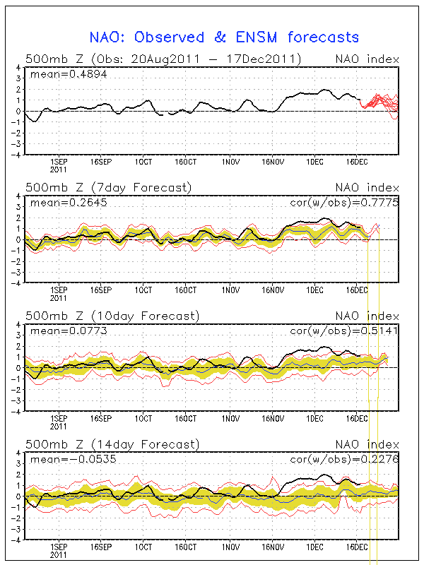
Positive NAO - http://www.ldeo.columbia.edu/NAO
Christmas is just a week away and snow chances for many in the eastern half of the nation look pretty bleak. The next major system to pull through on Tuesday and Wednesday will produce snow in the Plains, but to the east it's expected to be all rain. A second low moving through the Deep South on Friday will bring more rain, but most of that will stay south of Kentucky and the heaviest south of Tennessee. After that point it looks pretty dry right through Christmas. Why so rainy and relatively warm lately? It has to do with the North Atlantic Oscillation, or NAO for short. When the NAO is negative, storms tend to ride up the East Coast or just west of the Appalachian Mountains. This is a recipe for snow for many across the East since these storms have cold air streaming in just to the north of their track. When the NAO is positive, storms begin deflecting northward to Canada before they reach the Mississippi River. This means that the cold air and snow with these storms stays out in the Plains. The NAO is in this positive phase right now and isn't forecast to go neutral or even negative until around the new year (see forecast and history chart to the right). Until we can get the NAO negative, I wouldn't bet on a winter storm for Kentucky, Tennessee, or much of anywhere else in the East.

23% of the United States is covered by snow at the moment, which is quite a bit lower than the 47.3% covered by snow at this time last year. Aside from Lake Effect snowcover in Pennsylvania and New York and snowcover in northern Maine, the East is snow-less.

A big winter storm is forecast to hit New Mexico, the Texas/Oklahoma Panhandles, and Kansas on Monday and Tuesday as an area of low pressure cuts northeastward (because of the positive NAO as explained above) through the Plains. A Blizzard Warning (green color on right image) has been issued for Northeast New Mexico while the other areas are under a Winter Storm Watch. Areas in the core of the snowfall north of Amarillo, TX up through Dodge City, KS could get well over a foot of snow.

Sunday, December 12, 2010

12/12 - 10am - Louisville Snow Still on Track

It's snowing in Louisville as of this writing and more of the white stuff is on the way. We'll see off and on snow showers today, but they should increase in coverage and intensity as we begin to see snow bands from Illinois cross into the region later this afternoon and evening. I'm still thinking we'll get 1-3" here in Louisville (down a little from yesterday because the cold air did not catch the precipitation fast enough last night) and some areas just to our north could see 4 inches. In contrast, areas around Minneapolis have seen over 20 inches of snow since Friday and the inflatable dome of the Minneapolis Metrodome, home of the Minnesota Vikings, has collapsed.

Winds will be a big issue later on today as they begin to increase and pick up the dry snow on the ground along with what's already falling. Visibilities could fall as this happens, so use caution if you're out and about. Side and back roads could be problematic as well due to snow cover and black ice that could have formed last night. Interstates and major roads look fine based on some of the traffic cameras I've looked at this morning, but use caution.

Wednesday, December 23, 2009

12/23 - 3pm - Plains Blizzard, Snow in Louisville?

The big storm getting ready to spread rain around Louisville on Christmas Eve will slam into the Plains as a major snowstorm with blizzard conditions possible. Ice will be a big issue out there as well, especially in places nearer to the area of low pressure like Omaha and Lincoln, Nebraska. Some places could end up with more than 20" of snow, especially in areas north of Nebraska. Winter Storm warnings and watches have been issued as the storm cranks up today.

Rain should begin in Louisville early tomorrow and taper off as we go through Christmas Day. I know it's a bummer to have rain around Christmas like this, but at least we won't have any travel problems around the region.

The next chance of snow could come just before the new year. A system on the long-range GFS computer model is still showing some potential for us, even though we are not forecast to get any snow as of now. The storm track at the moment is very far south of us, but the GFS model has been notorious for shifting suppressed storms northward a few days before the actual event. This happened with the current storm. As you may remember, the current Plains storm was supposed to track south of us and give us snow, but the northward trend took over and sent the storm west of the Mississippi River. My only concern with the potential New Year's storm is that we may have a surge of warm air from the south, which could limit our snow chances. It's really far out to be making any sort of detailed prediction at this point, but I think this storm will make a snowy impact on parts of the region.

Thursday, November 13, 2008

11/13 - 5:30pm - Oh Dear, Is It Time for the GFS Blizzards to Start?

Yep, you guessed it! The GFS has a blizzard on it for the 23rd of November:


The "storm" gives MO, IL, and IN a large amount of snow, with a little less on the backside for us due to the position of the low. The blizzard was on the model Tuesday for a different date, but of course the weather world went nuts as this came out today. Obviously this is ten days out, but its something to wish for. They don't call it "wishcasting" for nothing! But seriously, if this thing can be reproduced on later runs then we might have a big storm to deal with. I'm not going put any sort validity on this storm until I see way more proof of its existence in the forecast.

It actually wasn't too bad of a day was it? The sun came out and temperatures actually breached 60! The rain machine will turn on again tomorrow afternoon and continue until Saturday, when snow showers will come into the area as the temperature drops in the afternoon and evening. By Sunday morning we could have a dusting on the grass, but I now think that temperatures might be too warm for any road problems, which would have been small to begin with. That's good news! A fridgid week ensues after this system passes. Look for highs in the...drumroll please...40s.

***UPDATE: The storm is on the 18z GFS run too, but it is weaker. We still get quite a bit of snow if this works out!

Wednesday, November 5, 2008

11/5 - 8:30pm - Wild West Weather, WAVE Visits My School

A well-advertised cold front is sweeping through the Plains, bringing with it Blizzard Warnings in the Dakotas and a Tornado Watch in Oklahoma and Kansas. This same front will come through here Thursday night, but with much less effect. We should see rain mixed with some lightning throughout Thursday night before a clearing on Friday morning. What you'll really notice is the drop in temperature, from mid 70s tomorrow to lower 60s on Friday and then 50 degrees for a high on Saturday. 50s will dominate the weekend and most of next week, if not all.

We received a pleasant surprise in my government and politics class today as WAVE TV's David McArthur came by to get some reaction from yesterday's election. You can see the whole piece that the station put together here. (I'm in the orange shirt from 1:04 - 1:28)

Saturday, March 8, 2008

3/8 - 9:30am - It's not done yet!

Just amazing... 8 inches at my house right now with some areas of Jefferson County reporting up to a foot. It's still snowing really hard, and we're expected to receive another 2-3 inches this morning.

Many counties in S. Indiana are under a state of emergency right now and asking residents not to even go out.

What caused all of this was a classic case of a banding snowstorm last night. What happens is that thunderstorms from down south drift north in bands and then start producing snow when they hit the cold air, producing thunder snow (which we had a lot of last night). We've just been slammed by band after band since the first one came through at 11:30pm last night.

We're on the tail end of it now, so it should stop at around 11am unless any new bands form. This is already as bad as Dec. 2004 in Louisville, and we're not done yet!

Friday, March 7, 2008

3/7 - 2pm - Storm Coming Along

There is a huge band of heavy snow in Arkansas making its way up here for tonight. That's where we'll see the 8-10" total accumulation come out of. There's also some heavy banding just SE of Louisville that'll make things treacherous in the next hour.

Sorry about the lack of a video today... the storm has made getting errands done very difficult. I'll see if I can get a late one out tonight.

I'm checking up on some blizzard conditions that are possible tonight... could get really nasty during the overnight hours.

We have anywhere from 2-3 inches on the ground already and we're just getting started!