Showing posts with label sleet. Show all posts

Sunday, December 30, 2012

12/30 - 8pm - Anyone Up for a Third Round of Wintry Weather?

With two winter weather events within a week's time in the books for Kentuckiana, it's apparently time for a third! Unfortunately the timing for this one is pretty bad. Just as folks are going home from New Year's parties in the early hours of Tuesday morning we could have snow, sleet, or even freezing rain falling in the region. The good news here is that regardless of what falls from the sky, there won't be much of it. Precipitation amounts will remain light since heavy rain and storms in the South will be stealing our moisture here up north in Kentucky and Indiana during the time of the event. As far as timing goes, a few snow showers will move through tomorrow afternoon as this system begins to move toward us. Going into the evening is when things get tricky.

As a weak area of low pressure continues to approach we'll see some warming aloft out ahead of it. This warming has the potential to turn our falling snow into sleet or even freezing rain. The GFS is leading the charge at the moment on the potential for freezing rain in Louisville as it has a layer above freezing from 4,000 to 7,000 feet at 4am on Tuesday morning that would support freezing rain. The NAM model keeps us all snow with the entire atmosphere being below freezing. Given that the models have overestimated temperatures aloft with the past two snowstorms we've seen lately, I'm inclined to think that Louisville will stay mostly or all snow. Another thing to focus on will be surface temperatures. Should they be just below freezing this snow, sleet, or freezing rain will stick to the roads and make for tricky travel on late Monday night. If they're just above freezing then only expect to see accumulation on the grass and elevated surfaces. We do have a bit of snowcover in Louisville now, so that might lean us more in the direction of below freezing instead of above for this event overnight Monday into Tuesday. We're going to be awfully close to freezing for much of the night regardless. Areas north of the city will likely stay all snow and below freezing while those areas to the south will see a wintry mix and temperatures just above freezing until the early morning hours. National Weather Service offices across the Plains have issued Winter Weather Advisories due to this system, in purple on the image to the left, but uncertainty about precipitation type and amounts in the Ohio Valley has NWS Louisville waiting for more agreement before they issue any advisories.

Like I said before, accumulations are going to be light for this event. The NAM (right) has up to an inch of snow in many areas and the GFS model has been a little more optimistic at times today with 1-3" across the area. Like the last two snow events, I'm thinking that the amount of precipitation being put out on the models will adjust upward a bit as we get closer to time (tonight and tomorrow morning). Given the trends I'm seeing right now I think we'll see 1-2" of snow in portions of Louisville and points northward with up to an inch of snow and mixed precipitation to the south. Once again... grumble grumble grumble... Louisville is right on the line between feast and famine with the snow. Southern Indiana has been the big winner with snow over the past week while folks south of the Ohio River are raising their hands in favor of more. That is, if you're a snow lover of course. So, we'll be looking to see over the next few hours how the models handle the amount of precipitation forecast, and temperatures both aloft and at the surface. Shifts in these could mean some significant changes to the forecast for many areas!

Saturday, February 11, 2012

2/11 - 5pm - A Wintry West Tennessee Forecast

A front that passed through West Tennessee last night brought rain showers during the overnight hours and snow showers this morning across the region. These have since moved out of the area, but the snow came down in some heavy bursts at times even though there was really no accumulation. High pressure will provide the setup for a very cold couple of days with highs in the 30's and overnight lows in the teens. Yikes! Tonight could be the coldest night of 2012 so far, which really isn't saying much since we've been pretty mild as of late.

Monday's forecast is flat-out complicated. Warm air overriding the retreating arctic air mass in place from this weekend will set the stage for a storm that could put down snow, sleet, and even freezing rain. Most indications are that this will start off as snow across most of West Tennessee on Monday afternoon as the lower layers of the atmosphere moisten up, but this snow could switch over to a period of wintry mix later on in the evening as the atmosphere warms up more (notice the warm "push" at 850 mb - 5000 ft on the left). Once we reach a certain threshold of warming on Monday night into the wee hours of Tuesday morning, all the snow, sleet, and freezing rain should transition to plain rain and the wintry weather headaches will be no more. Before everything switches over to rain an inch or so of snow could be on the ground around the I-40 corridor, including Jackson, according to the latest forecast models. Areas in Northwest Tennessee will switchover to rain a little later on than I-40, so there may be up to two inches on the ground. This is nowhere near set in stone yet and I'm willing to bet we'll see a few small changes in this forecast before the weekend is over.

The models agree that snow will fall across West Tennessee on Monday, but there are differences in when exactly this warm layer aloft will come in enough to switch the snow and wintry mix over to rain. The 18z NAM seems the most conservative on snow amounts at this point, with only a half inch in Jackson on Monday night. It also suggests that we might avoid a wintry mix and switch immediately over to rain. There's even a brief shot of rain just before the snow starts on that model. The GFS is bullish on snow amounts with over an inch in Jackson with the aforementioned wintry mix period (depicted as freezing rain on the BUFKIT output to the right) before the switchover to rain. The main issues seem are the timing of the warm air intrusion aloft and how strong it will be. So while this won't be a huge winter weather event by any stretch of the imagination, a few travel issues may crop up on Monday evening as the snow and wintry mix is falling.

Check out the video below from this morning's newscast on WBBJ for more details on your forecast!

Monday, January 10, 2011

1/10 - 5pm - Winter Storm Wrap-Up

After a few hours of sleet and snow, Starkville, MS finally switched over to all snow just after 8pm last night and around three inches of accumulation occurred. It was less than many expected because of the slow switch-over from sleet/freezing rain to snow, but nevertheless it was a significant storm. Areas near Corinth and Tupelo, MS received the most snow of anyone in the state, with ten inches in some places. Back in Starkville, temperatures have now warmed up to 34 in town, so the roads and sidewalks have melted. With the roads still wet and temperatures going below freezing tonight, there's a pretty good chance that ice could develop out there. Regardless of where you are across North Mississippi, West Tennessee, and Alabama, be very careful when traveling overnight and tomorrow morning.

Check out this video I put together that chronicles the storm at Mississippi State University from beginning to end:

Wednesday, December 15, 2010

12/15 - 11:40pm - More Ice in Louisville?

Jefferson County Public Schools are closed today (Thursday) due to the ice accumulations overnight. Great decision given the dangerously slick roads and driveways in Louisville. I know I have a few readers who go to my Alma mater duPont Manual High School, so you guys have the day off. Enjoy and be safe!


***2:30am UPDATE***
The temperature is now up to 28 °F in Louisville as warmer air drives northward. Still think we'll be below freezing for the next few hours. I just snapped a picture of some icicles forming on our deck railing at my house... check it out. Took another walk around my driveway as well and found that ice skates were preferable to tennis shoes. Don't go out if you don't absolutely have to for the next few hours.

***1:45am UPDATE***
My driveway (and most sidewalks/untreated streets in Louisville) is a sheet of ice and we're still awaiting another big batch of freezing rain in Louisville. That precipitation should be here within minutes and we'll continue to see freezing rain fall until around 7am or just before. Temperature at my house is 26.7 °F and the airport is still holding at 27 °F. You have to go down to Bowling Green, KY to find temperatures just above freezing, so I don't think any relief in the form of warmer air will make it here in time to spare the morning commute in Louisville. Still some snow falling to our north and east, but it's transitioning to sleet/freezing rain as warmer temperatures aloft work their way northward. I still think we're on track to get somewhere near 0.5" of accumulated ice here in the Metro, especially since radar returns are filling in to our west.


We started out with some snow in the Louisville area around 10pm this evening, but most of Jefferson County has now switched over to freezing rain and sleet. With what I'm seeing on radar and surface observations, the heavy snow will still fall in areas just northeast of Louisville as you go toward Cincinnati. The heavy ice accumulations are going to happen right here in Louisville I think, up to a half inch or more in places. Areas near Springhurst and Prospect in Northeast Jefferson County may pick up some of that heavier snow, but most of Louisville will stick with freezing rain and sleet overnight unless temperatures above the surface cool a bit. I'll continue to monitor the trends, but as of right now I think Louisville and points south aren't going to see any more snow tonight except for a few snowflakes.

No word on school cancellations in Louisville yet (JCPS says they'll make a decision at 4am), but I'm already seeing reports of slick roads in the suburbs. It's 25 degrees here at my house and 27 at the airport, so the liquid rain that's falling from the sky is freezing on the surface. Needless to say, things are going to be very slick on those untreated roads in the Metro tomorrow if temperatures continue to stay below 32 at the surface with freezing rain tonight.

12/15 - 9pm - Snow/Sleet Initiating, Winter Storm on Track


***10:15pm Update***
Snow and sleet are falling simultaneously at my house in SE Louisville near Fisherville with reports of snow/sleet/freezing rain coming in all over Kentuckiana.

Helpful Tip: It's sometimes hard to tell what type of frozen precipitation is falling because it's dark outside. If you're having a hard time trying to determine what's falling, stick a flat object like a tupperware lid, book, magazine, or pan out your door for a few seconds and then bring it inside or under a light source quickly. If it's all wet, you're experiencing freezing rain, any ice pellets on there are sleet, and of course you'll be able to pick out the snowflakes visually. Be sure to do this very quickly so that you're able to inspect the accumulated precipitation on your flat surface before it melts!


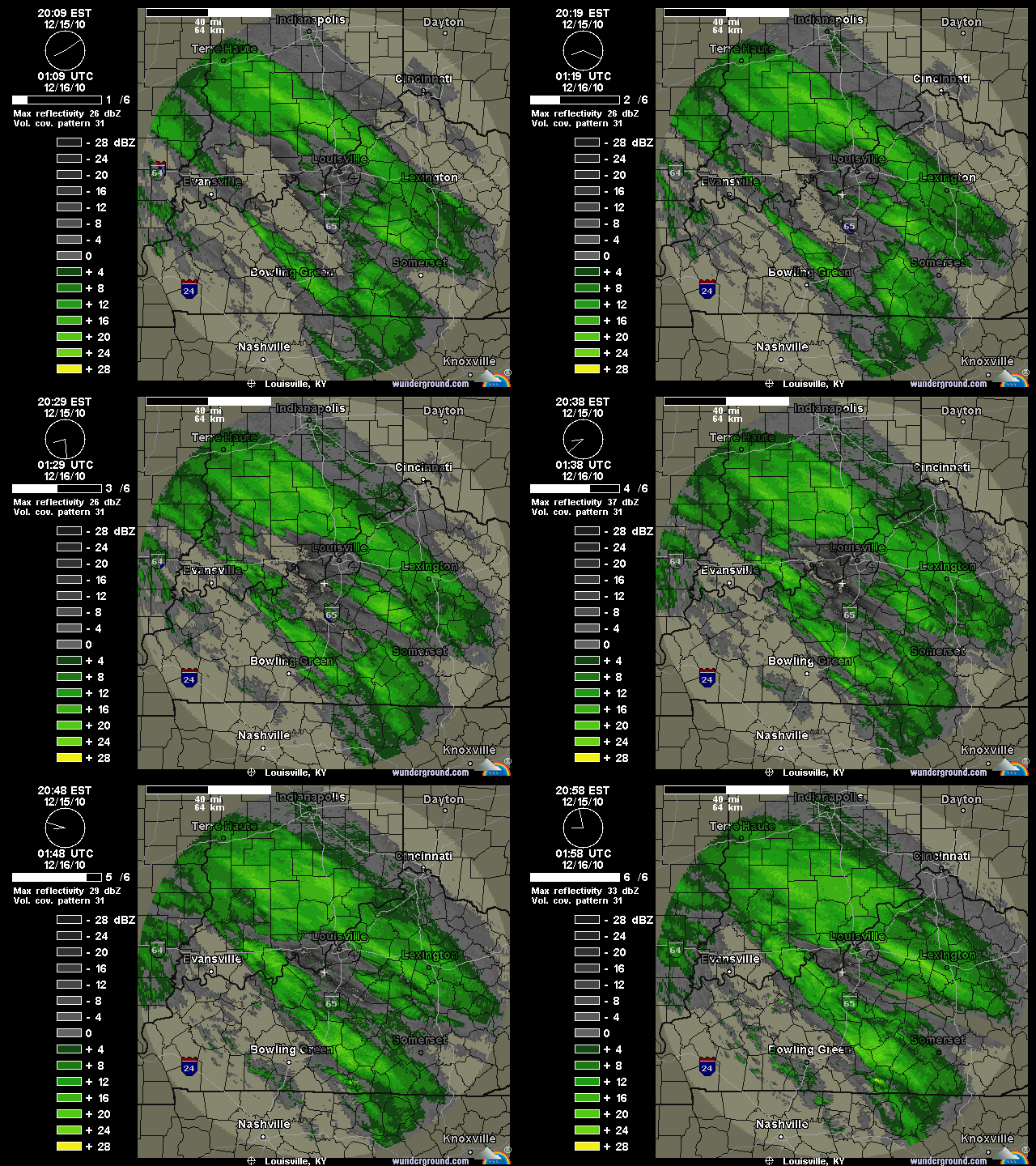
Precipitation is breaking out across Kentuckiana and reports of snow and sleet falling are coming in from those areas you see with precipitation on radar below:


The bands of precipitation to the southwest of Louisville are filling in quite quickly and we'll see those come into the Metro area within the next hour or two. We're still on track for 1-2" of snow before 1am tonight, but a few of the short-range models are indicating a 2-4" accumulation in Louisville if these snow/sleet bands fill in and set up well. We'll see if that happens, but for right now all eyes are on the radar. The snow and sleet will eventually turn in to freezing rain sometime between 1am and 2am here in Louisville, but areas to our northeast across the Ohio River in Indiana will most likely stay all snow and sleet and see accumulations over six inches in some cases. Areas to the south and west of Louisville like Elizabethtown, Bowling Green, etc will have little snow and see mostly sleet and freezing rain tonight. The good news for them is that surface temperatures have a good shot at getting above freezing later on tomorrow, whereas here in Louisville and points north that probably won't be the case.

I'm getting lots of questions about schools being open tomorrow and right now I can't supply a definite answer. Locally in Louisville I think the side roads and streets will be dangerous tomorrow morning (4-10am), so that will probably be a strike against schools being open tomorrow. Road crews are hard at work on interstates and major roads, but we'll see how surface temperatures cooperate with that overnight. Areas to our north with the heavy snow will also see many cancellations. This is still very much a "wait and see" game right now, but it's not looking too good for us weather-wise at the moment.

12/15 - 5:30pm - Louisville Winter Storm CRUNCH TIME!

The onset of Louisville's first major mixed precipitation winter storm of the season is just hours away and the forecast is still very difficult. The National Weather Service has extended tonight's and tomorrow's Winter Storm Warning to counties in Southern Indiana that were previously only in an advisory. The reason for this is the increase in precipitation totals that both the NAM and GFS have been hinting at today. Those areas in Indiana will see all snow and sleet, with accumulations up to six inches in places.

Here in Louisville the snow should start from the southwest near the 10pm hour and possibly mix with sleet before 1am, with accumulations of around 1-2". Based on the model guidance I've seen, I think we'll switch over to a period of sleet with some freezing rain mixed in after 1am. Freezing rain will become dominant in Louisville just a couple hours after that and last until around 7am with ice accumulations ranging from 0.25" to 0.5". The 18z GFS model (pictured top left) and the NAM both keep Louisville just below freezing at the surface during the entirety of the winter storm, but we're going to have to watch that. The snow we have on the ground will influence the surface temperatures across the area, so the computer models may be running too warm at this point. As I've said before, Downtown Louisville could get a degree or two above freezing during the afternoon and that will help road conditions improve tremendously. The 18z NAM BUFKIT output (second image on left) gives Louisville 1.7" of snow/sleet with a half inch of ice accumulation.

Even with all of this data nothing is set in stone. The storm is forming to our west right now and we're already seeing light snow and sleet falling to our west and southwest. Watching the radar trends and surface observations overnight (called nowcasting) will be crucial to see who gets what kind of precipitation. Louisville is historically the battleground between precipitation types and we'll be in that situation for sure tonight. The HPC (Hydrometeorological Prediction Center) has Louisville and areas south in a Moderate Risk for 0.25" of ice accumulation. Louisville and points north have been put under a Moderate Risk for 4"+ of snow accumulation as well, so we may very well end up with quite a bit of both snow and ice here in the city.


Should this system shift south just a few miles, Louisville would end up with mostly snow and accumulations would pile up to nearly half a foot. I've posted the 12z NAM snow accumulation output on the left just so you can see how incredibly close the heavy snow will be to Louisville, at least according to that model run. A shift northward would severely limit snow accumulations and put us in a mostly ice situation. Either way, Kentuckiana is set to get walloped by winter weather tonight. This will not be as bad as the January 2009 ice storm due to lesser ice accumulations and the potential for slightly above freezing temperatures during the daytime hours in Downtown Louisville and areas south of town as well. We'll see how it all plays out!

Monday, December 13, 2010

12/14 - 12am - Cold is Here and Another Louisville Storm Looms

My apologies for posting so late today. I didn't expect the recovery time from my wisdom teeth removal procedure this morning to last so long, but I think I'm about 95% back to normal now. Cold temperatures are the big story tonight as clouds continue to clear out of the area and cooler air filters in from the northwest. Low temperatures will hover around 8 degrees early tomorrow morning and we're already well into the teens at the eleven o'clock hour here in Louisville. Check out some of the surface observations on the image to the right. Indianapolis and Evansville, IN are coming in at 9 degrees at the moment with temperatures getting even closer to 0 as you make your way toward Peoria, IL. Wind chill values will get a few degrees below zero tonight, especially in the suburbs of Jefferson and surrounding counties.

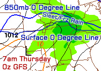
Our attention turns to yet another storm that should affect the Louisville area as soon as Wednesday evening. If you thought this past storm was a bear to forecast, try figuring this one out! Since temperatures will be hovering near freezing at the surface across the area with upper-air temperatures varying, this is going to be a real mess. The 0z NAM model run keeps Louisville and points northward mostly in the snow, but the 18z GFS had quite a mixed bag of precipitation for us, including freezing rain, sleet, snow, and plain rain. The 0z GFS is just now coming in and it appears that there will be a longer period of snow here in Louisville according to that run, but freezing rain or sleet could take hold on Thursday as warmer temperatures make their way in aloft (still need time for the BUFKIT output to be generated to find out exact precipitation type). If I had to guess right now, I'd say that Louisville and Southern Indiana will start out as snow on Wednesday night before switching over to either sleet or freezing rain sometime early Thursday before gradually changing back to snow as the storm ends. Should temperatures at the surface get just above freezing on Thursday, that period of freezing rain could turn to plain rain at times.

It's a real sticky situation as you can gather from my comments above. Since just a few miles will make a difference during this Wednesday/Thursday event, snow, sleet, and freezing rain amounts will vary wildly across Kentuckiana. I'll have an update tomorrow with more specifics and hopefully the computer models will have a better handle on this storm by then.

Check out some video that I shot of today's snow accumulations in Louisville below:


Be sure to select either 720p or 1080p and play at fullscreen for a high-definition experience.

Tuesday, January 26, 2010

1/26 - 5pm - MSU Forecast Video

The winds should finally die down tomorrow, meaning things will not be as brisk around MSU. Rain is in the forecast for Thursday night into Friday, which could be heavy at times. There is still some uncertainty over whether we will receive any frozen precipitation on Friday afternoon as this system exits the area, so be sure to check back on Twitter and Facebook for any late-breaking changes. Areas to our north in Tennessee and Kentucky could get quite a few inches of snow and some ice out of this system!

Friday, January 8, 2010

1/8 - 4pm - Bitter Cold!

We may have missed out on the snow here in Starkville, but the cold certainly hit us hard last night. Here's this weekend's forecast:


That's right, no above freezing temperatures until Sunday at the earliest. Many have asked me why MSU missed the brunt of the winter storm yesterday. The answer is quite simple: Temperatures were warmer than forecast on the computer models. Temperatures at the surface were cold enough for snow to stick during some points of the morning yesterday, but warmer than expected temperatures aloft changed most of the snow to rain and sleet. Only a few miles north of MSU the dominant precipitation type was snow, especially in places like West Point and Tupelo. This is a classic example of how hard it is to forecast snow. A degree or two and a few miles can make a big difference!

Be sure to bundle up if you're out this evening, because temperatures will get down into the lower teens again tonight. Walking to class this morning was brutal by Mississippi standards. Temperatures were in the 15-17 degree range and winds were gusting to around 20, making the windchill dip into below zero territory. We should see a warm-up next week, so getting around campus should become bearable again!

Jefferson County Public Schools back home in Louisville closed today because of the first major accumulating snow of the season up there. Louisville received between 2.5 to 4 inches, making some back roads pretty hazardous. Here's what it looks like right now out my window at home:


Pretty sight, eh? We'll see if Louisville gets anymore snow next week.

Wednesday, January 6, 2010

1/6 - 6:30pm - Video Update on Mississippi Winter Storm

This video has the latest on our winter storm:


(Click the HD button to view this video in high-definition)

As of now, it looks like one to two inches of snow could fall in Starkville. Some freezing rain and sleet could mix in early in the morning, but we should switch to all snow by mid morning. Driving could be hazardous, so be careful out there tomorrow!

Tuesday, April 21, 2009

4/21 - 6:30pm - Time to Warm Up!

Can you believe that some locations around the Louisville area had sleet today? Temperatures near 50 and cold upper-air temperatures made today miserable with rain and sleet coming down and a pretty good cloud cover this afternoon. The last few sleet/rain showers are moving through the area right now and they should exit completely before tomorrow morning.

This is the last of the rain for the week as temperatures skyrocket starting tomorrow with a high near 65. Mid 70's should be around for Thursday, with highs in the low to mid 80's for Friday through the weekend. Wow!

Wednesday, March 11, 2009

3/11 - 5pm - Talking Snow Again

The cooler air behind the front that passed through last night was sure a wake-up call. Winter is not over yet! There is even a chance of snow and sleet tomorrow night as temperatures dip below freezing and a bit of moisture comes up from the south. There shouldn't be more than a dusting in Louisville, but I think up to an inch is possible in Central and Southern Kentucky. At any rate, accumulations should be contained to the grassy areas because the ground is still warm from our recent run in the 60's and 70's.

During the day tomorrow we may have a hard time making it to 40. Friday will be a small improvement over tomorrow, with temperatures nearing 50 degrees. Mid 50's and a chance for rain will be possible during the weekend.

Tuesday, January 27, 2009

1/27 - 10am - That Was Only a Preview

Here's what it looks like at my house:


(I don't think my sister will be riding her scooter today!)

If you haven't gone out and tried to get a handful of this stuff, you should. It's very thick and difficult to even pick up; This stuff is not good for sledding. Tomorrow afternoon will be a better time to go sledding once more snow gets in here early tomorrow morning.

But first, a dangerous ice storm is on the way from Arkansas:


This will be here by the mid to late afternoon hours spreading quite a bit of freezing rain and sleet across the area. If this gives us mostly freezing rain, then be prepared for some power outages. I think we could get .25" of ice accumulation, which is pretty bad, but not disasterous. Here's a video of Jim Cantore from The Weather Channel talking about this storm in Paducah... click here.

After the ice is done tonight, more snow is on the way. The NAM and GFS both show a pretty potent area of snow coming through early tomorrow:


From these two models, I'm thinking that the area will generally get 3-4 inches of snow tomorrow morning. Isolated amounts of 6 inches are possible as well, so that should give us better sledding conditions.

Interstates are beginning to improve a little bit after the mess earlier this morning. Use caution if you must go out today.

Monday, January 26, 2009

1/26 - 4:30pm - More Ice, Less Snow

WINTER STORM WARNING - 10pm tonight until 1am Wednesday.

Here's how things stand at the moment for tomorrow during morning rush hour:


I think the heaviest snow will be just north of Louisville, with temperatures staying just below freezing at the lower levels up there. Here in Louisville, I expect 3 to 4 inches by tomorrow morning. This is down just a bit because I think we'll transition to ice earlier than previously thought, meaning some of that 3 to 4 inches will be sleet on the ground. We could pick up another inch of sleet and snow throughout the day on Tuesday before the snow picks up again on Tuesday night. I'm thinking we'll have another inch or two of snow out of that by Wednesday. The total snow/sleet accumulation for Louisville should top out at around 5-6 inches by the time Wednesday morning rolls around. Points south of Louisville will see 2 to 3 inches tonight, but a transition to sleet will happen sooner in the morning. Freezing rain in the afternoon down there could trigger dangerous ice storm conditions as well.

Now... if we get even warmer at the upper levels, we'll see lower amounts of snow and more ice. Freezing rain is not out of the question either. The general gist is that we'll see more sleet, but snow should be the dominant precipitation tonight and early tomorrow morning. We should stay below freezing all day tomorrow, but that's subject to change. If things trend colder at 85omb (5000 feet), which I do not think will happen, then expect more snow. Either way, driving will be messy tomorrow morning and there will be numerous school closures.

Sunday, January 25, 2009

1/25 - 8:30pm - Quick Snow Forecast Update

The models have been going a bit to the north with this system over the course of today, meaning we'll see some sleet and maybe freezing rain. We're still looking good for 5 inches or so, but the amount of ice on top of that is increasing with each model run. The heaviest snow will fall just to our north in Indiana, with 8 or more inches there. If we start seeing colder temperatures at 850mb in the model runs tomorrow, we're in for some heavier snow. For now, I think this will be a moderate snow event tomorrow night with an icy mess on top by Tuesday afternoon. We're still on for a little bit of snow on Tuesday night and Wednesday morning as well, so an inch or two could be appended on to the current 5 inch estimate. There's still plenty of time for things to shift tomorrow, so keep up to date!

Tuesday, December 23, 2008

12/23 - 11:30am - Freezing Rain ADVISORY

If you've been outside this morning, some of you may have noticed a light coating of sleet on your front porch or driveway. More sleet and freezing rain is on the way for this afternoon as moisture comes into the area from the west with warmer temperatures aloft. Accumulations will be light, so the National Weather Service has issued a Freezing Rain ADVISORY. Since we're already holding at around 30 degrees in Louisville, I expect any precipitation to change to plain rain later this afternoon. This should be all said and done before nightfall with few travel problems, if any. Temperatures will be heading higher during the overnight hours, so another changeover to frozen precipitation is not expected tonight.

I hate to say it, but we have nearly 2 inches of rain on the way according to the HPC. This will fall from tonight until tomorrow night, leaving Christmas Day clear and sunny. This scenario verifies on both the GFS and NAM, so I'm confident we won't see any surprise rain on Christmas morning.

Sunday, December 21, 2008

12/21 - 4pm - No White Christmas, But an Icy Tuesday?

While we won't be lucky enough to experience a white Christmas, winter weather isn't taking a break. As our rain system for Christmas Eve enters the area on Tuesday, temperatures will be below freezing. This could cause some icing issues if it doesn't warm above freezing as fast as the models say it will. I think we'll definitely see a little bit of sleet and freezing rain on Tuesday afternoon with warm air entering the upper levels, but I'm not certain how long that will last. If we warm slowly at the surface on Tuesday, we're in for an icy mess. If we warm quickly throughout the afternoon, we'll switch to liquid rain before the evening with little or no problems around the area. We'll just have to wait and see how this system treats us on Tuesday. In any case, we should be completely switched over to liquid rain by late Tuesday and into Wednesday (Christmas Eve).

Also, today is the first day of Winter! With a temperature of 22 in the city and winds making it feel even colder, it's sure making its presence known. After checking the latest runs of the GFS and NAM models, we're set for what looks to be the coldest night in quite some time. I think the Louisville Metro will see a low of 8 tonight, but the suburbs could get a couple degrees lower. Regardless of air temperature, wind chills will assuredly be below zero, so bundle up! Expect a repeat of today's weather for tomorrow, with a little less wind.

Tuesday, December 16, 2008

12/16 - 6:30pm - Was That a Hole on the Radar?

It was indeed a sad morning for snow lovers as everyone woke up to just a little bit of sleet. I recognized a trend southward trend in this storm starting around 10pm last night, but I figured it would correct itself. Add to that the fact that we had precipitation coming northeast from Owensboro that dissipated before it got here and then reformed in Oldham County. The result was what looked like a hole in the storm, right over the Louisville Metro. Both of these items led to the demise of the storm in the immediate Jefferson County area, but areas near Elizabethtown and Frankfort made out with around 4 to 5 inches of snow because of this. We only got a dusting of snow and a brief period of sleet and freezing rain last night and this morning.

We're pretty much done with this storm, with only a trace amount of freezing rain left to fall. We'll clear out the precipitation, but not the clouds tomorrow. Highs should range in the mid 30s. A round of thunderstorms could come through on Thursday night and Friday as a reinforcing shot of cold air comes in. We'll see yet another rollercoaster of temperatures for the end of the week, with 55 on Friday and then mid 40s on Saturday.

I'll keep my eyes peeled on the computer models to see if we can get any REAL snow in here, snowlovers. For those who despise the flakes, you're in luck for the next few days.

Monday, December 15, 2008

12/15 - 4:15 - We've Just Begun - WINTER STORM WARNING

I want to express my condolences to those who expected a half day of school and did not get one today. Colder air did not filter in until this afternoon, so our rain stayed liquid. That's making the evening commute much more enjoyable, so that's definitely a good thing!

The newest NAM model (18z) is really putting down some heavy precipitation here for later tonight into early tomorrow morning. I'd say 2-4 inches of snow on top of .25" or more of ice based on what I'm seeing. In terms of school cancellations tomorrow... they are possible. They'll make a decision early tomorrow morning based on what we actually get. All I have to say is that conditions will be bad until at least the noon hour. The WINTER STORM WARNING has been extended to 7pm tomorrow night as well.

For right now... there is an area of freezing rain and/or sleet moving east from Evansville. This should hit here sometime between 5 and 6pm tonight:


Expect a majority of the snow to fall after midnight, with sleet or freezing rain possibly mixed in.

Sunday, December 14, 2008

12/14 - 10pm - MIXED PRECIPITATION TOMORROW

After a couple model runs, I'm convinced we'll see sleet, freezing rain, and snow tomorrow afternoon and night. The GFS and NAM both backed off on this in their 18z runs, but the brand new 0z run of the NAM has brought a majority of the precipitation back. I'm awaiting word from the NWS in Louisville as to whether we'll have an advisory issued tomorrow or a full-blown Winter Storm Warning. Either way, I still think we're in for up to .25" of ice with up to an inch of snow on top by Tuesday morning.

As far as early dismissals for schools tomorrow, I think it'll be a close call. The NWS says it'll be below 32 after 5pm, but we could see an earlier drop in temperature if this cold front accelerates. That'll be interesting to watch over the next 12 hours. For Tuesday, If we do get up to .25" of ice, I'm expecting quite a few school cancellations and delays.