

Monday, April 22, 2013
4/22 - 6:30pm - Great Start to the Week, Rain Ahead in Starkville
Wednesday, April 17, 2013
4/17 - 6:35pm - Severe Weather Tomorrow in Mississippi

Thursday, April 11, 2013
4/11 - 7pm - Rough Day of Severe Weather, Sunshine to Come

Tuesday, April 2, 2013
4/2 - 10:45pm - After Some Rain, a Warm Weekend in Mississippi
 A stationary boundary stretched across Mississippi is giving folks to the south quite a bit of warm weather this evening but we're cooling down here in Starkville as we remain on the north side of it. An associated area of low pressure currently in Texas will move through the region later this week, triggering showers on Wednesday and Thursday. While temperatures will take a small tumble on those days we'll warm up vigorously into the 70's by the weekend. Check out your CampusConnect Forecast below for all the details!
Monday, March 25, 2013
3/25 - 11:35pm - Weather Says January, Calendar Says March

Wednesday, March 6, 2013
3/5 - 11:55pm - Warmer Weather Ahead in East Mississippi!

Thursday, February 28, 2013
2/28 - 10pm - Snow Showers Possible in MS This Weekend

Tuesday, February 19, 2013
2/19 - 11:30pm - Strong Storms in Mississippi Later This Week
 After a nice warm day in Starkville we're gearing up for a cooler, cloudier day tomorrow before storms set in on Thursday. The Storm Prediction Center has issued a Slight Risk of severe weather on Thursday for areas southwest of Starkville. We're right on the fringe of it. Since moisture return and instability look rather limited, the potential in the Golden Triangle for severe weather will be fairly marginal and centered around gusty winds, heavy rain, and frequent lightning. It's certainly something to watch though. Rain should clear out for the weekend and leave us with a warm and partly cloudy stretch of weather. Check out the video below for all the details!
Thursday, February 14, 2013
2/14 - 11:55pm - A Curveball Forecast for MSU Baseball

Tuesday, February 5, 2013
2/5 - 10:30pm - Dense Fog Tonight

Thursday, January 31, 2013
1/31 - 11:15pm - Snowy to Our North, but Clear Here!

Wednesday, January 30, 2013
1/30 - 7pm - Fulfilling a Childhood Dream in Weather and Television
Watch the video for Ryan's big announcement!

 While other childhood dreams came and went, this particular fascination with weather and my desire to get a degree in meteorology never fluctuated. In middle school I had finally made up my mind that becoming a meteorologist would be the ultimate end game for me. Since then I've been working every single day to make sure that I could become the best meteorologist that I could be. WAVE 3 was a huge part of this because John Belski and others would routinely post things on the Internet that I could learn from. I grew to really enjoy watching this station as a student because the meteorologists who worked there were different. They each knew the area very well, used sound science in their forecasting, and most importantly, had a passion for weather I've not seen anywhere else. This hasn't changed.

Tuesday, January 29, 2013
1/29 - 5:45pm - Serious Severe Weather Concerns Tonight
Latest Severe Weather Updates
 A severe weather setup that we see normally in the springtime is about to unfold on this late January night across a large expanse of the Southeast. While not "unprecedented" or "once-in-a-lifetime", this outbreak is going to impact quite a few people and it's important that everyone have what they need to be prepared and safe. This post is mainly for folks in North Mississippi and West Tennessee, but you can figure out pretty well how you'll be affected if you're not in these areas by some of the maps and information below. Everyone needs to be aware of what's going on because this will be happening at a very bad time of night when even the night owls are asleep.
Fast Facts
 A MODERATE Risk of severe weather has been issued by the Storm Prediction Center for the overnight hours in West Tennessee and most of North Mississippi. Tornadoes, damaging winds, and hail are all on the table for these areas as storms move through. Even though places like the Golden Triangle in Mississippi are just outside of the Moderate Risk area I would treat this as if you were in it because these storms are going to be very, very strong still as they move through this region. Please, please, please have a weather radio or smartphone app that's armed and ready to alert you if a Tornado Warning is issued for your location tonight. This will be hitting when most people are asleep so it's a very dangerous situation.
Timing - North MS and West TN
8pm - Midnight - Small chance for some isolated storms. These would carry a tornado, wind, and hail threat.
Midnight - 2am - Slightly better chance for isolated storms, small line of storms may try to form ahead of main line.
2am - 7am - Main line of severe thunderstorms moves through. This will affect everyone. Tornadoes, severe damaging winds, and hail are a good bet during this time.
Discussion
 A line of storms stretches from the Great Lakes to Texas right now and will continue to move eastward through the evening. A few reports of severe weather have come in already from this but the main show will be overnight as this line of storms encounters a more rich environment for severe weather.
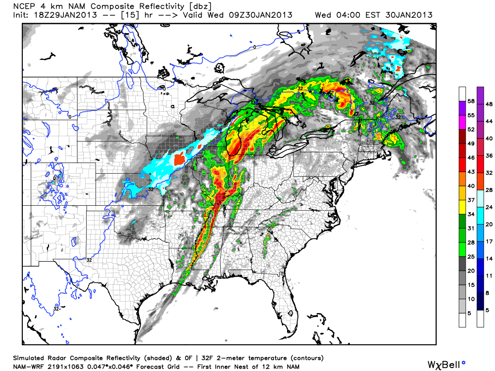 The main storm mode for tonight will be a squall line of storms with embedded rotation in portions of it (AKA what's termed a QLCS). Supercell storms will be possible ahead of the main line of storms too and could easily produce tornadoes if they develop. Tornadoes in QLCS lines of storms like the one we'll have tonight are more difficult to identify on radar since they're embedded within the line. While not as strong as supercell tornadoes, QLCS tornadoes can be strong and cause massive damage in the right environment.
 Also, since winds at 850 mb (about 5,000 feet) will be howling it will not take much for any part of this line of storms to pull these winds down to the surface and create straight-line wind damage. I wouldn't be surprised if folks affected by the worst of these winds thought they were hit by a tornado. I'm hearing the word Derecho being thrown around a bit with regard to how this system will develop tonight. That's certainly a possibility with this system but I think it's a relatively small chance.
Follow me on Twitter and my Facebook page for the latest updates tonight!
Thursday, January 24, 2013
1/24 - Ryan's Top Weather Apps for 2013
 Last March I made a blog post listing some of my favorite weather apps. Since the mobile weather landscape has changed a bit since then I've updated this list for 2013. With the ever-growing number of mobile devices there is similar growth in the weather app market and it's difficult to keep up with all the new apps. The apps listed below are ones that I use on my mobile devices as a student of meteorology, a broadcaster, and a storm chaser. Some of these apps are great for everyone while others are more suited to die-hard weather geeks and professionals. I'd like to point out that I use an iPhone and an iPad, but I've indicated which of the iOS apps that I use are available for Android too. I've not listed prices for these apps, except for the free ones, since they are subject to change.
RadarScope - (iPhone/iPad and Android)

 Radarscope is by far the most feature-packed weather radar viewing app for mobile devices at the moment. I've been using this app since it was released in 2008 and have been impressed with the subsequent updates that have been applied since. This app is so powerful because it allows you to view radar products like base reflectivity, base velocity, VIL, echo tops, and now even dual-pol products and Level 2 SuperRes data. If you don't know what any of that means and just want a simple radar app to show you where you are in relation to the storms around you, this is still an app for you. It displays weather warning polygons, which are essential because you're able to easily see which storms are severe near your location or anywhere else in the US. If you're a die-hard weather geek or storm chaser, this app also accepts packaged weather data plans from AllisonHouse for expanded capabilities. There's even a Mac version of this app that many use in place of the famous GRLevelx suite of radar apps for Windows that cannot run on a Mac.
MyWarn - (iPhone, Android in development)

 MyWarn is a simple app that alerts you of severe weather that will affect your location. Efforts to turn your smartphone in to the equivalent of a NOAA Weather Radio have been made with other apps before, but this app does it differently and simply. MyWarn's one and only function is to alert you when severe weather watches and warnings are issued for your current location, much like a real weather radio. The interface is very clean and there are quite a few settings in the app that allow you to customize which alerts you want to receive. Something I really like about this app that I've not seen in others is that it will alert you when the Storm Prediction Center issues a severe weather risk for your area, which gives the user a lengthy heads-up that severe storms may be an issue later in the day. The alerts are shown in graphical form once you open up the app so that you can see where exactly where you are inside the watch or warning area. The app's simplicity is what caught my attention because users generally don't want to fiddle with complicated setup wizards and a daunting number of customizations.
 Weather Underground - (Free - iPhone/iPad [WunderMap] and Android)

 Weather Underground has an impressive app because it leverages a few key features that other general weather apps don't have. Besides displaying a computer-generated for your location and a weather radar, which just about every other major weather app does, Weather Underground's app displays weather observations from their network of over 24,000 personal weather stations around the world. This means that you can get more precise current observations for your location because chances are one of these neighborhood weather stations are closer to you than the official observations. The app also displays live weather webcams from users who have opted to put those online along with their current weather data. Finally, and most impressively for weather geeks, is the ability to listen to live streaming audio from NOAA weather radio stations across the country on the smartphone edition of the app. These audio streams are crowd-sourced much like the observations and webcams, so your mileage may vary with availability of these streams for your area.
InstaWeather - (Free/Paid - iPhone and Android)

 InstaWeather takes posting your weather photos on Instagram to a new level. Using weather observations nearby, InstaWeather overlays on your photo the current temperature, winds, humidity, and more at your location. There are quite a few choices in what kind of data you want to show up on your photo along with multiple styles of how that data is presented. You're not just limited to Instagram with your photos though as the app allows you to post directly to Facebook and Twitter as well as save the photo to your phone's camera roll for further sharing options. The pro version removes ads from the app and mention of the app's name from your photos. While the social weather app field is a crowded one, this app stands out for its simplicity and cool factor.
mPing - (Free - iPhone and Android)

 mPing is the mobile version of the National Severe Storms Laboratory's PING Project. This project seeks to create algorithms that will better identify what kind of precipitation is falling in your neighborhood based on model data, radar data, and civilian reports. That's where you come in! This app allows you to report what kind of precipitation you're seeing at your location (rain, sleet, snow, etc) so that NSSL can bundle your report to the data that they have. The hope is that the end result of this project will be a radar product that will allow you to see exactly where sleet, snow, rain, hail, and other types of precipitation are falling instead of the loose rain/snow/mix algorithms (AKA the green, white, and pink that you see on TV radar displays) that are used now. Help the future of meteorology by sending in your reports!
Soundings Mobile - (iPhone/iPad)

 Soundings Mobile is an app that is mainly aimed at die-hard weather enthusiasts, meteorologists, and storm chasers. This app allows for viewing of both observed and forecast atmospheric soundings at any location where the National Weather Service sends up daily weather balloons. This app displays Skew-Ts and hodographs and even shows a box of stats like CAPE, CIN, LCL, etc that you would find at the bottom of most sounding output pages online. The intriguing thing about this app is that the soundings displayed are not images ripped from the SPC or another online source but rather rendered on the device from the raw data. This means that you can zoom in on and manipulate the sounding without distorting the quality of what you're looking at. This app is great on the iPad but performs well on the iPhone too with an interface adapted for the smaller screen size.
WeatherGeek Pro - (iPhone/iPad and Android)

 WeatherGeek Pro is for, well, weather geeks! It is a fairly simple forecast model viewing app that displays output from the GFS, NAM, SREF, WRF, RAP, and other models. As an added "bonus", you can view MOS output for any location within the app. This is a great app if you need to keep up with the latest model runs without the added frustration of navigating NCEP's website on a small screen. The app now has items that you can buy within the program with like ECMWF model viewing and additions map views for certain models. This is not an app I'd recommend unless you have some experience with weather models and forecasting.
 AeroWeather makes it easy to keep up with your favorite METAR sites and the TAF forecasts for them. While these products are aimed at aviation they are useful to any meteorologist or weather geek looking for raw METAR data. An example of when I use this app the most is during winter weather events with mixed precipitation types. At a glance you're able to see exactly who's reporting snow, who has freezing rain, and who is seeing sleet. The free version of this app displays the surface observations and their TAFs while the paid version expands upon that with radar images, webcams, and further airport information for pilots.
These are eight apps that I use frequently, but this doesn't mean that there aren't other good ones out there. Leave a comment on this post with your favorite weather apps!
(Disclaimer: I did not receive compensation for or was asked to post this list of apps. These apps are merely ones that I use and enjoy personally and I receive no financial incentive for mentioning them on this blog.)
Wednesday, January 23, 2013
1/23 - 7:15pm - Rainy End to the Week, Nice Weekend!
 |
| Tonight's low clouds aren't showing up well on infrared satellite imagery. |
Sunday, January 20, 2013
1/20 - 2:45pm - Bitter Cold Air is Arriving Soon!
 Temperatures in the 30's were common last night in West Tennessee and North Mississippi but temperatures are poised to drop much further than that tonight. A dry and relatively marginal cold front is moving through West Tennessee right now and that cold front is the first of two cold shots for the region. This will put lows down into the mid 20's in West Tennessee and lower to mid 30's in North Mississippi as cold air pours in behind the front. This cold air won't allow temperatures to rise much during the day tomorrow either, with highs in the upper 30's closer to Jackson, TN and closer to 50 down toward the Golden Triangle in Mississippi.
Temperatures will moderate during the week thanks to the return of wind flow from the south. This return flow means more moisture in the air across the region. You might guess that this warmer air and more moisture will eventually lead to rain chances... and you'd be right! A low pressure system and associated upper-level shortwave disturbance will track through near the end of the week, bringing rain chances. There's some disagreement between various models over whether this will start on Thursday or Friday. The GFS model's timeline on this is posted below. My guess at this point is that the timeline you see below will be delayed by about 12 hours, so expect rain chances to creep into the region ahead of this low on Thursday afternoon and continue through the night into Friday.

 It's not out of the realm of possibility that a little bit of wintry precipitation may fall on the backside of this system on Friday. If cold air flows in behind a cold front associated with this system fast enough then some of the last few rain showers could mix with or change over to a brief period of snow. The GFS identifies Kentuckiana as being the prime target for this but we all know that model has been trending too warm lately in all the winter weather events we've dealt with. So in my mind, West Tennessee is in a potential area for this mix or snow switchover to occur. We're too early for specifics on this so the forecast will have to be fine-tuned during the week. Stay warm!
Tuesday, January 15, 2013
1/15 - 8pm - Just Plain Rain for Starkville, but Snow Later?

Thursday, January 10, 2013
1/10 - 8:30pm - Tape Time
Happy New Year! I just got finished editing together my first professional weather resume tape. Well, it's not really a tape but that's what it's still called in the industry since tapes are a relic of the not-too-distant past. It's hard to believe that I've been doing weather on TV now for nearly two-and-a-half years. Time flies when you're having fun!
Subscribe to:
Comments (Atom)