Some heavy thunderstorms will make their way across Mississippi tonight as an area of low pressure and associated cold front to our south make an eastward run overnight. We could pick up over an inch of rain here in Starkville before it's all said and done tomorrow morning. Even though severe weather doesn't look likely for us at this point, some storms could have small hail and gusty winds. Areas south of Jackson, MS could see more potent weather as a Tornado Watch has been issued for that region as stronger storms are forecast to develop down that way this evening.
Once we deal with some cloud cover tomorrow and Thursday, things should clear out for the weekend and temperatures will make a nice recovery into the 70's. Check out the video below for your complete forecast:
Tuesday, March 29, 2011
Saturday, March 26, 2011
3/26 - 4pm - Southern Severe Weather Outbreak/West TN Storms
MS/AL Severe Weather
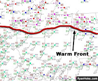
A warm front positioned over North Mississippi and Alabama is causing quite a bit of severe weather in the central parts of each state. Tornado Warnings are being issued for East Alabama, but nothing has been posted for Mississippi yet as storms haven't developed in this region. The atmosphere over Central Mississippi is very unstable at the moment and all we're waiting for is the cap (warm layer of air above the surface) to break, which will trigger some explosive storm development. There's no telling exactly when that will happen, but a good bet would be before nightfall. In any case, a Tornado Watch is posted for counties from Jackson to Tupelo, MS until 10pm tonight.
West Tennessee Forecast
A few strong storms passed through West Tennessee early this morning, but those dissipated just before the 6am hour. Storms are still ongoing in the region, but none are severe and no severe weather is expected. Storms should taper off tonight and cloudy skies will greet West Tennesseans tomorrow morning with temperatures in the 50's. More storms are possible on Tuesday. Check out my complete ABC 7 forecast in the video below:
Labels:
ABC,
Good Morning West Tennessee,
media,
meteorology,
Mississippi,
severe,
spc,
tennessee,
tornado,
TV,
video,
watch
Tuesday, March 22, 2011
3/22 - 5pm - What Month is it Again?
Is it really the end of March? Feels like the middle of May out there this afternoon with temperatures in the lower 80's and low humidity. Unfortunately we have to leave some of that nice weather behind temporarily tomorrow as a cold front swings through the South bringing with it a small chance for rain during the afternoon and evening hours here in Starkville. Things should clear out for Thursday and most of Friday, but warm Gulf air from the south and an approaching cold front will trigger a round of strong to severe thunderstorms on Saturday into Sunday. We'll see how that all pans out!
Speaking of severe weather, I just posted a countdown timer for my annual storm chasing trip to the right of this blog. Only 45 days until I leave for Amarillo, TX! Check out the video below your complete Mississippi State University forecast:
Speaking of severe weather, I just posted a countdown timer for my annual storm chasing trip to the right of this blog. Only 45 days until I leave for Amarillo, TX! Check out the video below your complete Mississippi State University forecast:
Labels:
front,
meteorology,
Mississippi,
Mississippi State,
severe,
spring,
thunderstorm,
TV,
video,
warm
Tuesday, March 8, 2011
3/8 - 5pm - Heavy Rain in Starkville, Severe Weather to the South
We've already seen a bit of rain here in Starkville today, but heavier rain and even some thunderstorms are on the way for the area later this evening. Severe weather is certainly an issue to our south and southwest, where there's a risk for tornadoes this evening. Once this system moves out of the area tomorrow afternoon, we'll see the rain clear out and some possible cloud thinning as well. It'll be cooler, but at least the rest of your week is rain free! Get all the details and your complete forecast in the video below:
Saturday, March 5, 2011
3/5 - 2:45pm - Heavy Rain Across West Tennessee
A Flood Watch remains in effect for West Tennessee until midnight and Flood Warnings have been posted for areas in extreme West Tennessee that have had some hefty rainfall totals this morning. All the heavy rain in the region is now coming to an end as a cold front moves eastward, bringing with it some cooler air and more stable weather. Check out my video below for all the details:
Labels:
flooding,
Good Morning West Tennessee,
media,
meteorology,
radar,
rain,
tennessee,
TV,
video,
WBBJ
Tuesday, March 1, 2011
3/1 - 5pm - Nice Week in Store for North Mississippi
Things are warming up across the region this week as we recover from the passage of a cold front yesterday. Clear skies and temperatures near 70 will be the rule as we head throughout Wednesday and Thursday, but rain chances will begin to pick up by Friday as another cold front sets its sights on the eastern half of the nation. Some strong storms are possible on Saturday with temperatures cooling down into the 50's by Sunday afternoon. Check out the video below for your complete forecast:
Subscribe to:
Posts (Atom)

