 You've probably heard it by now, but it bears stating again: A winter storm is going to impact the South this weekend. Even though we're less than four days away from the event, details are still relatively sketchy because of computer model inconsistencies. In this post I'll focus on Starkville, MS and Jackson, TN, two areas that are less than a couple hundred miles apart but could see wildly different winter weather scenarios.
Jackson, TN
The winter storm this weekend will be an all-snow event for Jackson and all of West Tennessee. The most current runs of the GFS model are indicating around two inches of snow accumulation by Monday afternoon in the region. The NAM model only goes out to 84 hours, so only accumulations through Monday morning were output on the 0z run, which stands now at around two inches as well. Since precipitation amounts will increase as you go southward and the exact track of this storm hasn't been determined, there's definitely room for more snow accumulation than what is on the current batch of computer models.
Starkville, MS/Mississippi State University
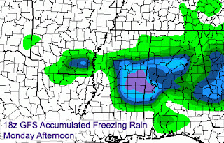
The forecast for Starkville is exponentially more difficult than areas to our north because the Golden Triangle could very well be the battleground between snow, freezing rain, and rain. The 18z GFS model puts a couple inches of snow on the ground here, but the bigger story is the amount of freezing rain that could accumulate. The graphic to the right is the accumulated freezing rain output from the GFS, which shows nearly a half inch of ice accumulation in Starkville by Monday morning. Just a couple counties to our north, snow accumulations could top four inches and ice may not be as much of an issue. Earlier runs of the GFS showed more snow for Starkville with ice becoming more of a problem just to our south. That's just one model though. The NAM, which as I said before does not cover the whole event period yet, seemed to go toward a warmer solution on the 0z run with a bit of snow late Sunday night and plain rain in town on Monday morning (left image). I'd give the NAM a few runs to get things sorted out because lately it seems to have had problems with storms that occur near the very end of it's forecast period.
 Areas near Tupelo could be the bulls-eye for heavy snow, so I wouldn't be surprised to hear reports of amounts over five inches up there early on Monday.
 Bottom line: Significant amounts of snow/sleet and freezing rain are possible in Starkville by Monday morning and we'll need to fine-tune the forecast to figure out which mode of precipitation will be more dominant. Any slight track changes or differences in the strength of the low that will pass to our south will determine what kind of frozen precipitation falls where. The good news is that I think temperatures during the day on Monday will get above freezing, so the mess on the roads during the morning should get better throughout the afternoon.
If you're near Jackson, TN this weekend, be sure to tune in to ABC 7 on Saturday morning at 6am for my latest snow forecast. Should be an interesting few days ahead!


No comments:
Post a Comment