Wednesday, November 30, 2011

11/30 - 4pm - Mid-South Winter Storm Wrap-Up

The National Weather Service in Memphis has released a snowfall map that recaps the measured snowfall totals across the Mid-South. Jackson, TN broke an all-time November snowfall record with 2.0", but note that slightly higher totals were recorded elsewhere in Madison County away from where the official observations are taken for the NWS. Look at those snowfall accumulations of over 5" in Northeast Arkansas and the Missouri Bootheel... very impressive! This was quite a rare storm and the method through which the storm produced the snow, a cut-off low that supplied its own cold air from aloft, is something that doesn't happen too often either.


The snow was even apparent on visible satellite this morning, which is amazing because temperatures were above freezing for most of yesterday:


Wintry weather should stay out of the forecast for at least the next week or so, but rain chances will be on the increase in West Tennessee early next week. The GFS computer model is hinting at the possibility of a little bit of snow late next weekend, but it's much too far out to make any predictions at this point. Certainly something to watch!

Monday, November 28, 2011

11/28 - 8pm - Starkville Christmas Parade Weather Report

This evening WOBV-TV 5 in Starkville, MS aired a weather forecast I put together for this year's Starkville Christmas Parade TV broadcast. Check out this video from tonight's program:


Scroll down to see my thoughts about the ongoing winter storm impacting much of the Mid-South right now.

11/28 - 2:45pm - An Early Shot of Winter Weather

A complicated upper-level low is making for some difficult forecasting over the next 24 hours as it brings the first real chance of snow to the South this season. This upper-level low is basically a big bubble of cold air aloft that has been orphaned from a bigger system that has since moved away from the region. Since we still have showers in the area, this cold air will help to turn those into snow by late tonight in areas near Starkville and northward. Since temperatures at the surface here in Starkville won't make it above 34 or so, any brief period of snow we see will not stick to the ground. I do think there could be a complete changeover to snow here in Starkville tomorrow morning around 8 or 9am, but this is highly dependent upon how well the computer models handle this system. Further north near Tupelo, Memphis, and Jackson, TN there will be enough cold air to get the snow on the ground when it falls, but the vast amount of warm rain we've had lately has kept the ground warm and moist, so snow accumulations won't stick around for long. Travel hazards won't be a huge deal since the roads are still warm, but it's a good idea to keep a look out for slick spots where temperatures dip below freezing tonight. Click on the SREF model snow output to the right... I think it has the most reasonable estimate on who will get accumulating snow tonight.

A Winter Storm Watch has been issued for areas from Tupelo to McNairy County, TN until 6am tomorrow since heavier snow could result in accumulations of 3 inches or more. The Winter Weather Advisory around the periphery of the Watch is for wet snow accumulations that could total around 1 to 3 inches. The snow should end by late morning tomorrow as it converts back to rain showers and then the precipitation will clear the area completely by around noon or so.

Check out my video below for a complete look at this week's forecast in Starkville and more details about the snow that's headed our way:


This evening at 6pm is the annual Starkville Christmas Parade. I'll be doing a short weather segment for the parade broadcast on WOBV 5 in Starkville. This event will also be streamed live on the web, so be sure to check out http://parade.wobv5.com/ tonight at 6pm CST to see my forecast and enjoy the parade!

Sunday, November 20, 2011

11/20 - 12:15pm - Active Weather on the Horizon

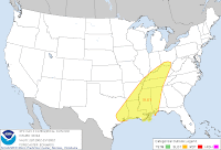
Heavy rain and storms are going to be sticking around the Southeast for the next couple of days as a stalled front sets up just northwest of Tennessee and Kentucky. Rainfall amounts in West Tennessee through Central Kentucky could exceed two inches by the time this is all said and done on Wednesday morning, leading to some flooding issues in areas (such as Northwest Tennessee) that have seen quite a bit of rainfall already this month. Something that has become more apparent this morning is the risk for severe weather on Tuesday (left image), when upper-level wind support will come in to play. The greatest risk for severe storms will be throughout most of Mississippi and West through Middle Tennessee. This severe weather threat will likely materialize as a line of storms carrying high winds and the risk for a few isolated tornadoes, but there could also be a few storms out ahead of the main line as well. Once we clear the storms out on Wednesday we'll be left with sunny skies and cooler temperatures throughout the region, giving us a very nice Thanksgiving! Check out the video below for my forecast on yesterday morning's edition of Good Morning West Tennessee on WBBJ:

Monday, November 14, 2011

11/14 - 12:45pm - Severe Risk Tomorrow in Mississippi

It's a dreary and humid one out there today but a Slight Risk of severe weather is in place for tomorrow across the western 3/4 of Mississippi as a potent system approaches. Severe storms are also possible around the Golden Triangle tomorrow as heavy rain, high winds, and even some hail moves through the region. This should clear out by Wednesday afternoon and leave us with clearing skies and cooler temperatures for the remainder of the week. Check out your complete forecast in the video below:

Saturday, November 12, 2011

11/12 - 2:30pm - Hold on to Your Hats!

It's going to be a windy and warm weekend across West Tennessee. Winds will likely reach 15 mph today and 20 mph with higher gusts on both days. Temperatures are going to be very nice, getting into the lower 70's by tomorrow afternoon. Rain will move through on Monday night, some of which could be quite heavy and will last until Tuesday morning. After the cold front generating these storms moves through on Tuesday, we'll be seeing temperatures only getting into the upper 50's by Wednesday. Check out the video below for all the details!

Monday, November 7, 2011

11/7 - 2:30pm - Sunny and Warm, Then Storms

If you haven't stepped outside today, you really need to do so. It's 72° in Starkville as of this writing and the mostly clear skies couldn't be any nicer. That will continue into tomorrow when we'll see highs near 80 degrees in some locations across North Mississippi and maybe a few more clouds. Storms will roll through on Tuesday night into Wednesday, but I don't expect any severe weather in the immediate Starkville/MSU area because of a lack of moisture to fuel these storms. On the other had, areas near Lawton, Oklahoma to just north of Abilene, TX are in for a good shot of severe weather with tornadoes possible. This threat will shift eastward to Eastern Oklahoma and Arkansas tomorrow with a few strong storms even making it to the Delta region of Mississippi. After the system bringing these storms passes through on Wednesday morning, we'll be left with much cooler temperatures and quiet weather. Check out my forecast video below for more details:

Saturday, November 5, 2011

11/5 - 2:45pm - A Foggy Start to a Nice Weekend!

It was extremely foggy in West Tennessee this morning as low-level moisture and chilly temperatures set in overnight. This morning on TV I showed a photo (left) from Kelton Halbert of the very low visibility at the Nashville International Airport early this morning. What a sight! The fog has dissipated and we'll be left with a very nice weekend with temperatures in the upper 60's to 70 degrees before our next rain chance on Tuesday night. This rain chance entails some strong storms, but current indications are that most of the severe weather will stay west of the Mississippi River as it rolls through on Tuesday night into Wednesday morning. Expect cooler temperatures for the end of the workweek. Check out the video below for your complete forecast: